An Inventory of the Historical Monuments in Herefordshire, Volume 3, North West. Originally published by His Majesty's Stationery Office, London, 1934.
This free content was digitised by double rekeying. All rights reserved.
'Huntington', in An Inventory of the Historical Monuments in Herefordshire, Volume 3, North West(London, 1934), British History Online https://www.british-history.ac.uk/rchme/heref/vol3/pp74-77 [accessed 30 April 2025].
'Huntington', in An Inventory of the Historical Monuments in Herefordshire, Volume 3, North West(London, 1934), British History Online, accessed April 30, 2025, https://www.british-history.ac.uk/rchme/heref/vol3/pp74-77.
"Huntington". An Inventory of the Historical Monuments in Herefordshire, Volume 3, North West. (London, 1934), British History Online. Web. 30 April 2025. https://www.british-history.ac.uk/rchme/heref/vol3/pp74-77.
In this section
34 HUNTINGTON (A.d.)
(O.S. 6 in. (a)XVII, S.W., (b)XXIV, N.W.)
Huntington is a parish on the W. border of the county, 4 m. S.W. of Kington. Huntington Castle and Turret Castle, both mount and bailey earthworks, are the principal monuments.
Ecclesiastical
a(1). Parish Church of St. Thomas of Canterbury stands on the N.W. side of the parish. The walls are of local limestone rubble, with dressings of the same material; the roofs are covered with slates and shingles. The church, consisting of Chancel and Nave, was built in the 13 th or at latest in the 14th century. The bell-turret and framing were inserted early in the 17th century. The church was restored in 1892, and the South Porch is modern.
Architectural Description—The Chancel (20 ft. by 16¾ ft.) has a 13th-century E. window of two plain lancet-lights. In the N. wall is a 14th-century window of one trefoiled ogee light; further W. is a modern organ-recess. In the S. wall is a 16th or early 17th-century window of two plain square-headed lights. There is no chancel-arch.
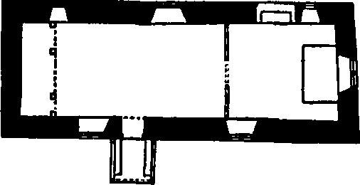
The Church, Plan
The Nave (37 ft. by 16½ ft.) has, in the N. wall, two windows, the eastern modern except perhaps for the splays; the western window is of uncertain date and of one square-headed light. In the S. wall is a two-light window, entirely modern externally; the 14th-century S. doorway has chamfered jambs and segmental-pointed head. The square timber-framed bell-cote, at the W. end of the nave, stands on four moulded posts with modern braces to the cross-beam and exposed timber-framing above.
Fittings—Bells: two; 1st by I. G. (John Palmer's foreman), 1671; 2nd by Isaac Hadley, 1703. Brackets: On external face of E. wall, S. of window, two shaped corbel-brackets, 1½ ft. apart. Floor-slab: In nave—to Thomas James, 1713 (?). Font: octagonal bowl with curved undersides, set diagonally on octagonal stem, probably 14th-century, base modern. Plate: includes two Elizabethan cups and cover-patens without dateletters, and a pewter flagon and plate. Seating: In nave— nine benches with moulded or trefoiled heads to bench-ends, probably 16th-century, E. bench incorporating moulded 17th-century panels. Sundial: On S.E. angle of nave—with initials and date I.P. 1639.
Condition—Good.
Secular
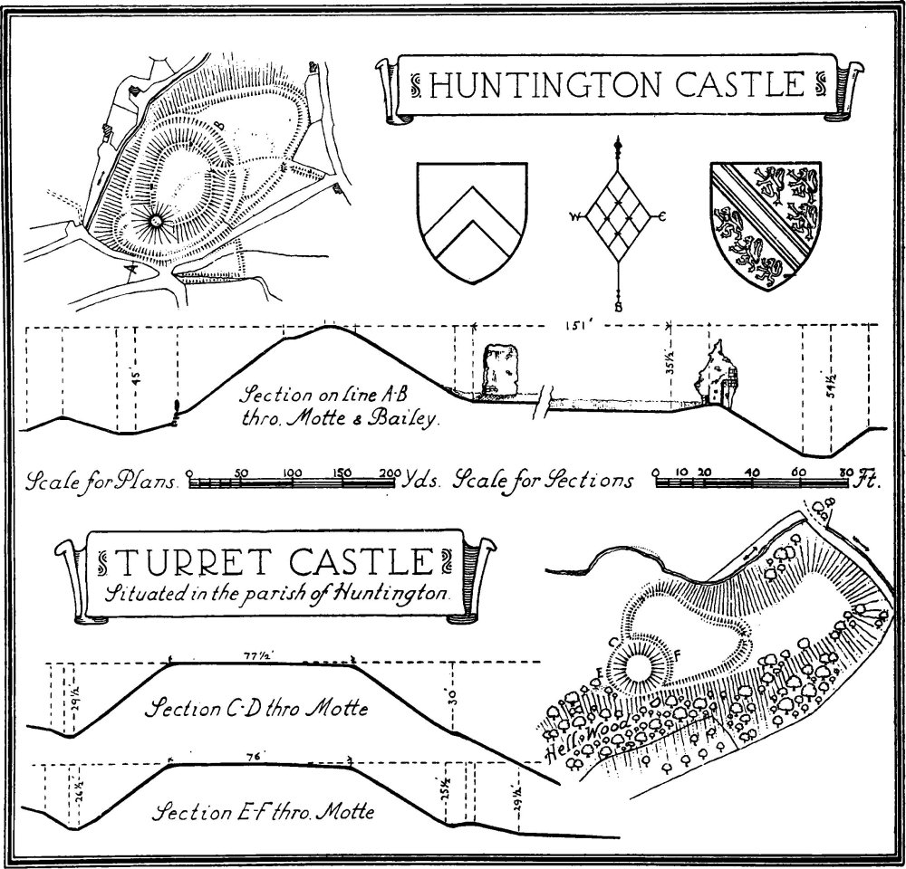
a(2). Huntington Castle (Plate 5), earthwork and ruins, ¼ m. N. of the church. The castle was in the possession of the families of Braose, Bohun, and Stafford during the Middle Ages. Some evidence has survived of the former buildings of the castle (Arch. Camb. 1869) and repairs were made to several in 1403 when a new ditch with palisading was made to the pond (vivarium) and barn; this perhaps refers to the enclosure of the outer bailey. In 1460 the castle was returned as worth nothing, which presumably indicates that it had then been abandoned. In 1521, however, one tower was still used as a prison. The Earthworks consist of a motte with an oval-shaped inner bailey to the N.E.; the whole is surrounded by a ditch except on the W. side where it is replaced by a berm, the natural scarp being very steep. There is an outer bank to the ditch on the S. and S.E. and traces also on the E. The outer bailey, to the N.E., forms a crescent-shaped enclosure with double scarping on the S. side and a ditch to the E. and N. The motte rises some 30 ft. above the level of the bailey and is about 124 ft. in diameter at the base. The inner bailey is approached by a causeway on the E. side which probably marks the site of the former gatehouse. The bailey was enclosed by a curtain-wall apparently carried up the motte on both sides; foundations of this wall remain in most of the circuit and one fragment some 20 ft. high is still standing on the W. side. Towards the N. are the remains of a tower with a rounded outer face and part of a small chamber in the adjoining curtain-wall on the E. This chamber has traces of a window and two small recesses in the W. wall. In the S. part of the tower are remains of a descending staircase or corridor. The tower appears to be of the 13th century.
Condition—Of earthworks, fairly good.
a(3). Turret Castle, remains of mount and bailey earthwork in Hell Wood, 980 yards E. of the church. The proximity of this earthwork to Huntington Castle and the known later occupation of the latter, seem to imply the priority in date of Turret Castle. The work occupies the base of a spur, running out towards the E., and consists of a circular motte with an irregular shaped bailey to the E. of it. The motte is about 52 yards in diameter at the base and rises some 29 ft. above the bottom of the ditch between it and the bailey. The bailey has remains of a rampart and also a ditch between it and the spur to the E. The entrance is on this side and it is possible that the remainder of the spur formed an outer enclosure.
Condition—Of motte, fairly good; of bailey, poor.
Monuments (4–14)
The following monuments, unless otherwise described, are of the 17th century and of two storeys, timber-framed and with tile, slate or stone-covered roofs. Some of the buildings have exposed timber-framing and ceiling-beams.
Condition—Good or fairly good.
b(4). Upper Hengoed, house, 1,600 yards S.S.W. of the church, is built of rubble and has an addition at the W. end.
b(5). House and barn, 60 yards E.N.E. of (4). The House has been re-faced in stone. The Barn, S.W. of the house, is of three bays, weather-boarded.
b(6). Barn, at Lower Hengoed, 1 m. S. of the church, is of one storey and of four bays, weather-boarded.
b(7). Hall's Mill, house, 380 yards E. of (6), is of stone.
b(8). Outbuilding, at Burnt Hengoed, nearly 1¼ m. S.E. of the church, adjoins the N.E. end of the house. It was built probably in the 15th century and has remains of three crutch-trusses. It was subsequently divided into two storeys. The crutch-trusses have collar-beams with curved braces.
b(9). Little Penlan, house and barn, in the S.E. corner of the parish, 980 yards E.S.E. of (8). The House was built probably in the 15th century, to which date belong the S.W. part of the main block and the S.W. cross-wing. Late in the 16th or early in the 17th century the main block was divided into two storeys and the N.E. part reconstructed or extended; the cattle-shed, forming a N.E. cross-wing, is of uncertain date. The upper storey projected on the three free sides of the S.W. wing, but has been under-built on most of two sides. The central block has an added gable on the N.E. front. There are two large 17th-century chimneystacks at the back. Inside the building, parts of two crutch-trusses are visible, and there is a doorway with a four-centred head.
The Barn, S. of the house, is of three bays, weather-boarded.
b(10). Great Penlan, outbuilding, formerly house, 370 yards N.N.E. of (9), has been re-faced in stone. The middle part of the building is of mediæval date and has three crutch-trusses; it was divided into two storeys, probably in the 17th century. Inside the building is a re-used moulded and embattled beam of the 15th century.
Huntington Castle
a(11). Penlan, house, 720 yards S.S.E. of the church, has been partly re-faced in brick and stone. It is of L-shaped plan with the wings extending towards the N. and E. The N. wing is of mediæval origin and has remains of crutch-trusses; the E. wing is an addition of the 17th century as are the outbuildings forming an extension of the N. wing. In the original part of the house is a doorway with a shaped head, perhaps original.
a(12). Swan Inn, 300 yards N. of the church, is built of stone. The E. wing and the N. end are later extensions.
a(13). Lower House, house and barn, 340 yards N.N.E. of the church. The House was built perhaps late in the 16th century but was much altered, partly faced in stone and the main block heightened in the 18th century. The Barn, N.E. of the house, is partly of stone.
a(14). Lodge Farm, house, 1,460 yards E. of the church, was built of stone, probably early in the 18 th century.
Unclassified
b(15). Mound, Turret Tump (Plate 5), 1,470 yards S. of the church, occupies the top of a knoll (916 ft.). The mound is roughly circular, 86 ft. in diameter at the base and 16½ ft. high. There are remains of a ditch, with an outer bank, on the S. side.
Condition—Fairly good.
b(16). Mound, on the S. edge of the parish, 550 yards S.S.E. of (15), occupies a slight natural knoll (790 ft. above O.D.). The mound is of oval form and partly natural. It is about 42 yards across, and rises about 9 ft. above the ground behind.
Condition—Fairly good.