An Inventory of the Historical Monuments in the County of Northamptonshire, Volume 1, Archaeological Sites in North-East Northamptonshire. Originally published by Her Majesty's Stationery Office, London, 1975.
This free content was digitised by double rekeying. All rights reserved.
'Islip', in An Inventory of the Historical Monuments in the County of Northamptonshire, Volume 1, Archaeological Sites in North-East Northamptonshire, (London, 1975) pp. 58-59. British History Online https://www.british-history.ac.uk/rchme/northants/vol1/pp58-59 [accessed 25 April 2024]
28 ISLIP
(OS 1:10000 a SP 98 SE, b SP 97 NE)
The generally rectangular parish, covering only 560 hectares, lies immediately W. of Thrapston on the W. side of the R. Nene between Cranford Brook on the S. and Harper's Brook on the N. The parish thus occupies an E.-W. ridge of land rising to 250 ft. above OD and falling gently on all but the W. into the valleys of the Nene and its tributaries. The crest of the ridge is covered with Boulder Clay, while on the valley sides limestones, sands and marls outcrop.
The parish contains an impressive group of prehistoric and Roman sites (1–5), discovered by air photography.
Prehistoric and Roman
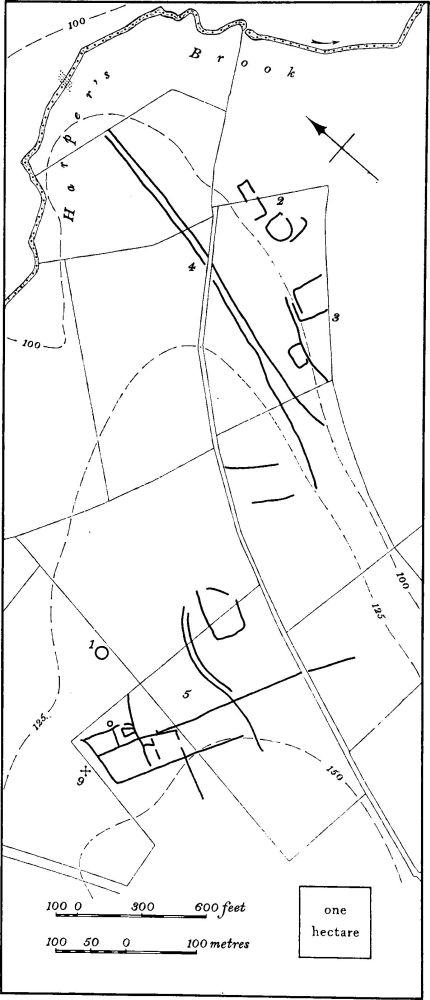
Fig. 70 Islip (1–15) Harper's Brook Complex (9) Saxon Burial
b(1–5) Harper's Brook complex (Fig. 70), in the N.E. of the parish, on a flat-topped sandy ridge between Harper's Brook and the R. Nene, around 125 ft. above OD. It is a direct continuation S. of the Henslow Meadow complex in Aldwincle parish which lies N. of Harper's Brook (Aldwincle (1–11)). The identifiable sites are listed below, but in addition, two barrows quoted as being 'in Islip Meadow' in the middle of the 18th century, and a 'Tumulus near Islip Mill', noted in the early 20th century, may have lain in the same area (T. J. George, Arch. Survey of Northants., (1904), 20; Surtees Soc. 80 (1887), 71–2). A 3rd-century coin found at Mill Farm, together with other Roman coins now in Northampton Museum, and a quartzite hammerhead, may have come from here. (BNFAS, 3 (1969), 14; OS Record Cards; J. Northants. Natur. Hist. Soc., XXXI (1946), 35)
b(1) Ring ditch (SP 98737980), diam. 18 m. (BNFAS, 6 (1971), 14).
b(2) Enclosure (SP 99347996) is of long narrow and rectangular form, and apparently incomplete on its W. side. The N. half has now been destroyed by gravel-working but excavation of the surrounding ditch revealed it to be nearly 2 m. deep. One sherd of Iron Age pottery, with curvilinear decoration of Hunsbury type, was found (CUAP, ZF4; BNFAS, 4 (1970), 41). Immediately to the S., air photographs show another sub-rectangular enclosure and a length of curving ditch.
b(3) Enclosures (SP 99307990), S. of (2). They comprise one small rectangular enclosure attached to a length of ditch with traces of what may be another larger enclosure to the N.E. Weathered Roman sherds and limestone rubble have been found (BNFAS, 4 (1970), 41; CUAP, ZF4).
b(4) Trackway and Roman remains (SP 99308032– 99157978). The trackway is visible on air photographs as two parallel ditches running N.-S., 10–16 m. apart, and widening to form a funnel entrance at the S. end. It probably ran N. across Harper's Brook to meet the Roman road crossing Henslow Meadow in Aldwincle (Fig. 16). There is an area of heavy stone slabs in and around the brook on the projected line of the trackway at SP 99308040 (CUAP, ZF4).
b(5) Settlement (SP 987796) comprises a compact group of enclosures and linear ditches of generally rectangular plan. A circular feature on the N. side may be a hut circle. To the N.E. is a short length of double ditch, possibly a trackway, and further E. is another enclosure, very indistinctly shown on available air photographs (in NMR).
b(6) Roman cemetery (?) (SP 98807848), on the side of the Nene Valley on gravel and limestone at 120 ft. above OD. In the mid 18th century, '3 or 4 collections of human bones thrown into heaps without order', together with fragments of Roman pottery, were found in a gravel pit on the S. side of the Kettering Road (Gent's Mag., 27 (1757), 20).
b(7) Roman (?) iron-working site (SP 970782), on the N. side of a deeply-cut valley on sand and clay at 150 ft. above OD. In about 1882 an old smelting furnace, consisting of a circular chamber with a lump of iron in the bottom, was discovered during ironstone mining No dating evidence was noted and the site may be either Roman or medieval (PSA, IX (1882), 90–91; OS Record Cards). Possibly from the same site a 'Roman Well ... lined with white tiles' (limestone blocks?) was discovered during ironstone quarrying (Northampton Independent, 11 Dec. 1909, 28).
See also (8) for Roman pottery from a Saxon cemetery.
Medieval and Later
b(8) Saxon cemetery (SP 970785), on the N. side of a deeply-cut valley on sand and limestone at 200 ft. above OD. A 'Roman' skeleton with a 'helmet', presumably a shield boss, was found hereabouts in the mid 18th century. In 1878 when the area was being worked for ironstone, three or four burials in graves, a shield boss, glass, beads and a large number of bronze brooches, clasps and buckles were found (Gent's Mag., 27 (1757), 20; PSA, IX (1882), 89–91). In 1917–18 further graves were discovered associated with numerous beads, buckles, brooches, shield bosses, spearheads, pottery and two glass dishes. Two Roman 'cinerary urns' were also found and it is possible that some of the graves were of Roman date (PSA, IX (1882), 89; XXX (1918), 113–20; Ant. J., XXI (1941), 234–6). The location of the site is different from that given by Meaney (Gazetteer, 190–1) and is based on OS map evidence (OS Record Cards; see also J. Northants. Mus. and Art Gal., 6 (1969), 37–41).
b(9) Saxon burial (SP 986797), N. of the village, immediately W. of (5). An inhumation burial, with two cruciform brooches, was discovered here during pipe-laying in 1965 (BNFAS, 3 (1969), 18).
(10) Cultivation remains. The common fields of the parish were enclosed by Act of Parliament of 1800 (NRO, Enclosure Map). Ridge-and-furrow of these fields exists, or can be traced on air photographs, only in the S.W. half of the parish. In this area are extensive remains of end-on and interlocked furlongs, mainly of reversed-S type. (RAF VAP CPE/UK 1994, 2422–6, 4425–9)