An Inventory of the Historical Monuments in the County of Northamptonshire, Volume 2, Archaeological Sites in Central Northamptonshire. Originally published by Her Majesty's Stationery Office, London, 1979.
This free content was digitised by double rekeying. All rights reserved.
'Weldon', in An Inventory of the Historical Monuments in the County of Northamptonshire, Volume 2, Archaeological Sites in Central Northamptonshire, (London, 1979) pp. 164-166. British History Online https://www.british-history.ac.uk/rchme/northants/vol2/pp164-166 [accessed 27 April 2024]
In this section
61 WELDON
(OS 1:10000 a SP 99 SW, b SP 98 NW, c SP 98 NE)
The parish has an irregular shape and covers about 1040 hectares, immediately E. of Corby. It lies on almost flat Boulder Clay land, between 98 m. and 107 m. above OD, but the down-cutting of the Willow Brook, here flowing N.E., has exposed large areas of Upper Lincolnshire Limestone. The present village comprises the two separate settlements of Great and Little Weldon, situated on either side of the Willow Brook. Considerable areas of the parish have been worked for ironstone, from which a number of Bronze Age burials (1) and (2) are recorded. More burials were discovered to the W., in what was then part of Weldon parish but is now part of Corby (see Corby (1)). A large and important Roman villa has been partly excavated (3).
Prehistoric and Roman
A stone axe 'of green slate' is recorded from the parish (VCH Northants., I (1902), 139). A polished flint axe (Plate 31) and another, partly polished, were found in the parish before 1893, the latter at or near Weldon Grange (SP 912886; NM). A fine chipped flint dagger was discovered in 1890 'near Weldon' (VCH Northants., I (1902), 139; T.J. George, Arch. Survey of Northants., (1904), 20; PPS, 6 (1932), 340–55; J. Northants. Mus. and Art Gal., 2 (1967), 38–9). It is now known to have been found at SP 911894 (BNFAS, 4 (1970), 57). In NM there are sherds of a large Collared Urn of the Primary Series, unlocated but possibly from Weldon (PPS, 27 (1961), 297, No. 126). The museum also holds parts of a Food Vessel found in Weldon before 1893. Two Roman coins (both in KM) have been found N. of the village (SP 922903 and 921905; BNFAS, 4 (1970), 62).
b(1) Bronze Age Burial (SP 92828934), found in 1930 during building work within Weldon village, on limestone at 84 m. above OD. A Collared Urn, one of the Primary Series, was discovered (KM; PPS, 27 (1961), 297, No. 125).
b(2) Bronze Age Burials (SP 922886), S.W. of the village, on limestone at 91 m. above OD. During ironstone-mining four inhumations and at least six cremation burials were discovered and excavated. Three of the cremations were associated with small Collared Urns (BNFAS, 5 (1971), 4; Northants. Archaeol., 9 (1974), 3–12; CBA Group 9, Newsletter, 1 (1971), 4).
b(3) Roman Villa (SP 92948999; Fig. 146), N. of the village, on limestone at 84 m. above OD. It was found in 1738 and partly excavated, but was re-excavated in 1954–5. Three periods of building were established, the final phase being a winged corridor villa. It was first occupied in the late 1st or early 2nd century and was abandoned in the late 4th century. A series of mosaic pavements was recovered as well as a coin dating from the mid 4th century. Various out-buildings were found, including a workshop with three furnaces, probably used in iron-working (Plans in Soc. Ants. Library and in the Gough Collection, Bodleian Library; Whellan, Dir., 814; VCH Northants., I (1902), 193; JRS, 44 (1954), 93; 45 (1955), 135; 46 (1956), 133–4; 47 (1957), 213–4; Trans. Anc. Mons. Soc., I (1953), 74–6; A. Rainey, Mosaics in Roman Britain, (1973), 89). A pair of Roman iron shears, a disc brooch and a blue glass bead (all in NM), of unknown provenance, may have come from this villa (OS Record Cards).
Medieval and Later
A coin of Edward the Confessor 'from Weldon' is in NM (T.J. George, Arch. Survey of Northants., (1904), 20). A coin of Ethelred II is also recorded (VCH Northants., I (1902), 255), but its whereabouts is unknown and it may have been confused with the coin of Edward. There is, in NM, a large, biconical bowl of Saxon date, decorated with incised lines and stamped circles, found in Weldon before (1921) (J. Northants. Natur. Hist. Soc. and FC, 20 (1921), 44; J.N.L. Myres, Anglo-Saxon Pottery and the Settlement of England, (1969), Fig. 44, No. 810).
b(4) Anglo-Saxon Burials (SP 92508946), found in Weldon village in 1968, during building work. Two inhumations, one with an iron knife of 6th or 7th-century type, were found in a shallow grave (OS Record Cards).
b(5) Moat (?) and Occupation Site (SP 92268970), found in the N.W. part of the village, probably in 1935–6, during building development. 'A mound standing a few feet higher than the rest of the field and surrounded by a shallow declivity which had the appearance of a one-time moat' was dug into. Finds included glazed pottery and massive foundations of a building (OS Record Cards).
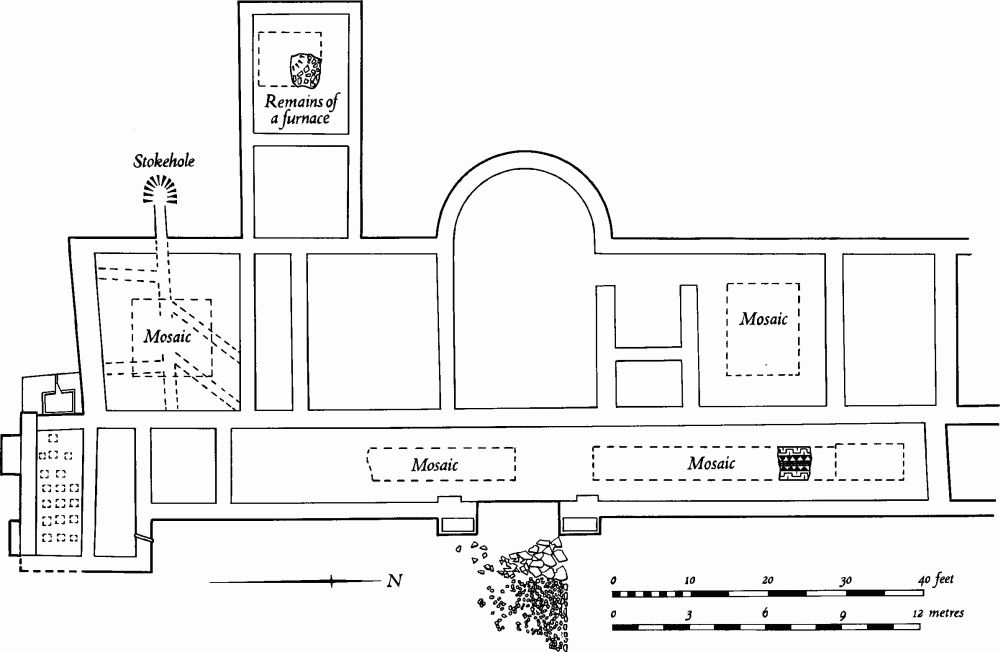
Fig. 146 Weldon (3) Roman villa (based on plan in Trans. Anc. Mons. Soc.)
b(6) Manor House Site (SP 92648929), immediately W. of the church, on Upper Lincolnshire Limestone at 84 m. above OD, on the S. side of a deep valley. The site, known as Hall Close, was that of the manor house of the Basset family who held Weldon from the early 12th century, but all the remains were finally destroyed in 1967–8 when houses were erected there. Before destruction 'considerable earthworks' including 'a level platform' and 'traces of what could have been fishponds' existed. Excavations in the area in 1970 were confined to the main 'platform', where the remains of a stone building, associated with 13th and 14th-century pottery, were discovered. This building was altered a number of times and then demolished and its area occupied by a courtyard. To the N. more walling apparently associated with 15th-century pottery was discovered. In the same area evidence of both pottery kilns and iron-working, all of the 12th to 13th centuries, was noted (Northants. P. and P., 4 (1970/1), 245–8). A building is shown on the site on a map of 1730 (NRO).
a(7) Deer Park (centred SP 945902; Fig. 147), covering some 60 hectares of land in the E. of the parish around Weldon Park Wood, on Boulder Clay at 91 m. above OD. In 1306 Richard Basset obtained licence to enclose into a park the Halgh Wood of 71 acres, situated in his manor of Weldon. Nothing is known of its later history but by 1587 (Map in NRO) the S. part of the park had been enclosed into two fields and lay outside the wood. The original park pale is traceable for most of its original course and is best preserved along the E. side. From the S.E. corner of the park until it meets the S.E. corner of the wood (SP 953896–951900) there is a well-marked bank some 1.5 m. high and 5 m. wide. Along the E. side of the wood the bank is very large, being up to 2 m. high and 8 m. across with an internal ditch. At the N. corner of the wood (SP 946906) the bank turns S.W. against the edge of the wood; here it is much reduced in height, being only 1 m. high. This bank continues beyond the N.W. corner of the wood. It then (at SP 940902) turns S.E. and rejoins the wood. It then extends S.E. as far as the modern Corby-Oundle road (at SP 946895) where it turns E.N.E. to complete the circuit. Until recent destruction there was within the wood (SP 946900) a roughly triangular open area, bounded by a low bank or scarp. This appears to have been the original medieval deer lawn or grazing area (Northants. P. and P., 5 (1975), 232–3).
b(8) Stone Quarries (centred SP 925890), cover some 25 hectares S. and S.W. of the village. They are cut into the Upper Lincolnshire Limestone of the Inferior Oolite Series. Many abandoned quarries and the remains of some old shafts remain, in addition to a small area still being worked. From these quarries came the well known Weldon Stone, which has been worked at least from the medieval period and probably even since Roman times (J.H. Taylor et al., Geology of the Country around Kettering, Corby and Oundle, (1963), 136; J.M. Steane, The Northamptonshire Landscape, (1974), 182–3; RAF VAP 541/612, 3081–5, 4062–4).

Fig. 147 Weldon (7) Deer park
b(9) Iron-Working Site (SP 928895), in the village, 200 m. N. of the church, on limestone at 94 m. above OD. Two stone bases, possibly for iron-smelting furnaces, and a length of stone walling are recorded. Medieval pottery and a large amount of iron slag exist in the area (Northants. Archaeol., 9 (1974), 111).
(10) Cultivation Remains. The common fields of the parish were enclosed by Act of Parliament of 1792. On a map of 1580–7 (NRO) the fields of that time are depicted and named. In the N. of the parish, between Little Weldon and a great belt of woodland, lay Nether Field, with a Little Field, now in Corby, to the W. There was another Little Field E. of Great Weldon village with Long Crofte Field to the S. of that village and Mill Field to the S.W. Owing to the existence of the Corby Steel Works and its associated ironstone quarries, very little ridge-and-furrow is visible in the W. part of the parish, but in the former Nether Field, Long Crofte Field and Little Field to the E. there are many end-on and interlocked furlongs.
In the S.E. of the parish, S. of Weldon Park Wood (centred SP 948890), there was, in the late 16th century, a large area of open waste called Weldon Plain. Around the N.W. and E. edges of this there were, and still are, several roughly rectangular fields, all of which have ridge-and-furrow within them, with headlands inside the field boundaries. This presumably represents early enclosure on the edge of the waste (RAF VAP 541/612, 3060–5, 3079–87, 4058–68, 4078–87; F21 58/RAF/ 1210, 0003–8; F22 58/RAF/1210, 0003–7, 0017–9; F22 58/RAF/2168, 0010–6; F21 540/RAF/1312, 0084–91; F22 540/RAF/1312, 0084–91).