An Inventory of the Historical Monuments in the County of Northamptonshire, Volume 2, Archaeological Sites in Central Northamptonshire. Originally published by Her Majesty's Stationery Office, London, 1979.
This free content was digitised by double rekeying. All rights reserved.
'Appendix', in An Inventory of the Historical Monuments in the County of Northamptonshire, Volume 2, Archaeological Sites in Central Northamptonshire, (London, 1979) pp. 186-191. British History Online https://www.british-history.ac.uk/rchme/northants/vol2/pp186-191 [accessed 3 May 2024]
In this section
APPENDIX
Roman Roads
For ease of reference, all Roman roads in the area are described here together and not separately under the parishes through which they pass. The roads are identified by the numbers given to them by I.D. Margary in Roman Roads in Britain, I (1955). Lengths of Roman road not previously recognised, and therefore not numbered by Margary, are given descriptions. This account of roads of Roman date does not include trackways some of which are probably of the same period; these are described in the appropriate parish inventory.
57a Middleton to Stanion (Figs. 168, 169 and 170)
This road, running from Leicester to Godmanchester, crossed the N.E. corner of the area under review. It entered the area near the point where the East Carlton— Middleton parish boundary meets the R. Welland (SP 823913) but no trace of it exists at this point, and it is not clear exactly how and where it crossed the Welland. It is first definitely visible to the S. of the Ashley road, in Middleton parish (SP 82789111–82979100), where there is an unusually wide medieval access-way between two blocks of ridge-and-furrow. This access-way, which runs N.W.—S.E., is exactly on the projected alignment of the road, and probably made use of it.
In the next four fields to the S.E. no trace of the road exists, and ridge-and-furrow covers any remains, but beyond this at SP 83449076 a wide ridge is clearly visible underlying the ridges of a block of reversed-S ridge-and-furrow just short of the headland. This ridge is 10 m. wide and 0.25 m. high, and continues into the next field where there is no ridge-and-furrow (SP 84499073). The ridge then crosses the line of the modern Ashley road, and is traceable in the field to the N. as a well-marked agger, 0.25 m. high and 12 m. wide (SP 84729060). It then passes under a track and is just traceable along the S. side of the adjacent field. For the next 650 m. there is no further indication of the road on this alignment, but then, on the N. side of Cottingham village, the alignment is taken up firstly by a short length of lane (SP 84509019) and then, after crossing the Rockingham road, by the existing lane to Corby (SP 84609014–85418970). This lane rises steeply up a N.facing escarpment and, at its S.E. end, is in a shallow cutting. It then meets the A 427 Market Harborough— Corby road which runs almost straight for 2.2 km. The present road has been much altered and widened as part of the Corby urban development and no remains of the Roman road are visible. Near the centre of this section, just N.W. of the present intersection with the A 6003 Uppingham—Kettering road (SP 86158934), the modern road swings N. of the projected alignment of the Roman road, but there is no trace of an agger in the arable land to the N. In 1969 a subway was constructed under this road (at SP 86818896) and the work revealed the agger of the Roman road, made of consolidated limestone-rubble, 1.37 m. thick and 13.7 m. wide. There was certainly a ditch on the S. side, but no certain evidence for one on the N. side was discovered (BNFAS, 4 (1970), 7; Brittania, I (1970), 288).
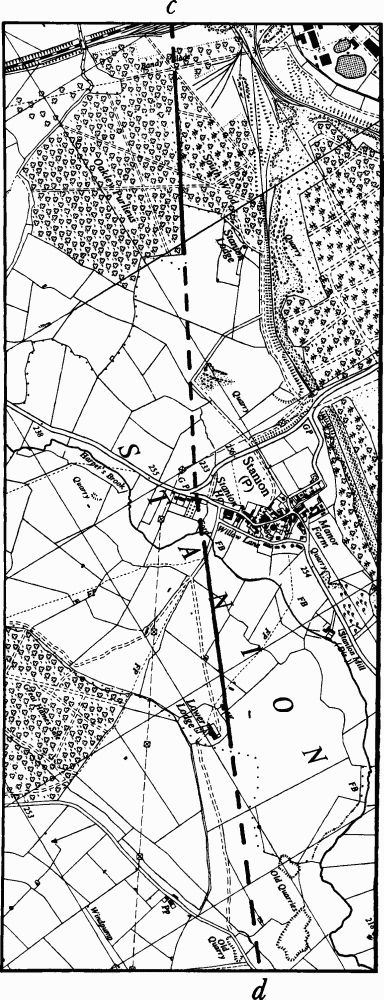
Just within Hazel Wood (SP 87208860) the modern road turns E. and the Roman road continues S.E. through the wood as a well-preserved agger up to 20 m. wide and 1 m. high with traces of a shallow ditch on each side for a distance of 470 m. (Fig. 168). At the S.E. corner of the wood (SP 87888837) the agger is broken down, and beyond this point modern houses, the railway and ironstone-mining have destroyed all remains until the edge of South Wood is reached (SP 89248763). However on air photographs taken before the housingdevelopment started in 1953 a light-coloured soil mark, presumably the ploughed-down agger, is visible for a distance of 200 m. immediately W. of Corby Sidings (RAF VAP 541/612, 3046–8; SP 889877). Beyond the railway, along the boundary between South Wood and Oakley Purlieus, the road continues on the same alignment as a well-marked agger, 18 m. wide and 0.25 m. high, with traces of side ditches. It then runs parallel with and 10 m. N. of the N.E. side of Oakley Purlieus (SP 89848731–90058719) where it is 12 m. wide and 0.25 m. high with a limestone-rubble core, now much spread by ploughing (RAF VAP F21 540/RAF/1312, 0108–9). Beyond the corner of the wood the agger continues S.E. as a slightly raised ridge with a lime-stone-rubble core, for some 350 m. after which it is lost for 1.25 km.
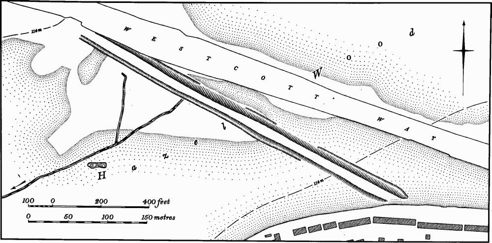
Fig. 168 Roman Road 57a, in Hazel Wood, Corby
S.E. of Stanion village the agger is again visible, on a slightly different alignment and in the same condition, crossing the high land N.W. and N. of Lower Lodge (SP 91658641–92358606; Fig. 120). Thereafter it passes into Brigstock parish (see RCHM, Northants., I (1975), 117).
570(?) Irthlingborough to Irchester (Fig. 170)
This road runs from Durobrivae, near Water Newton, Cambridgeshire, to Irchester. Its route from Duro brivae to Titchmarsh is well-known but thereafter its line is not clear. The Viatores (Roman Roads in the S.E. Midlands, (1964), 339–40, 494–5) suggested that it continued S., along the E. side of the R. Nene, through Thrapston and Higham Ferrers and then turned S.W. along the line of the modern A 45 to the Roman town of Irchester (7). However there is little evidence to support this line and RCHM (Northants., I (1975), 116–7) suggested an alternative route for the road on the W. of the R. Nene via Lowick, Woodford and Great Addington. The course of the road on this route is lost N. of Irthlingborough and there is no clear indication as to how and where it crossed the R. Nene. If the last known alignment of this road is projected S.W., it passes S.E. of Irthlingborough town centre, and crosses the Nene some 800 m. E. of and down-stream from Ditchford Bridge on the Rushden—Irchester boundary (SP 938685). There is no indication of a road on this alignment but if it indeed continued S. of the river it would have met the A 45 road where the latter crosses the Rushden—Irchester parish boundary (SP 932672). Just N.E. of this point, within Rushden parish (SP 933673), air photographs (RAF VAP F22 543/RAF/943, 0107– 8) show a faint cropmark visible for some 200 m. on the projected alignment. This cropmark may indicate the road. From the place where the present A 45 crosses the Irchester boundary, it probably coincides with the original Roman road for the next 850 m. Apart from a minor bend, near the boundary, the present road is straight and, if its line is continued W., is heading directly for the East Gate of the Roman town. However after crossing the Wellingborough—Bedford railway, the modern road swings off the straight alignment (at SP 924669) and passes in a broad curve S. of the Roman town. The Roman road almost certainly ran on straight into the town, although no trace remains owing to ironstone-mining and a tramway. The evidence from the excavations of 1878–9 E. of the town, which were said to have found indications of this road, is ambiguous (see Irchester (7)).
170 Dungee Corner to Irchester (Fig. 171)
This road enters the area from the S., at Dungee Corner, in the extreme W. of Bozeat parish. Its original source is not known with certainty though it is alleged to have been traced as far as Kempston, Bedfordshire (The Viatores, Roman Roads in the S.E. Midlands, (1964), 290–3). On the evidence of its last known alignment to the S.E. in Harrold parish, Bedfordshire, it is said to run through Dungee Wood, entering the county on the N.W. side of the wood (at SP 93045951). The Viatores (op. cit., 335 and 258) claimed that two other roads (210 and 175) meet near here, though the evidence is unsatisfactory and no clear indications have been noted. There is at this point a slight stony rise in the present arable land, just under 1 m. high and 6 m. across, traceable for some 25 m. running in a N.N.W. direction. The road should then have run on this alignment, converging on Green Lane until it meets the latter at its junction with the modern road to Hinwick (SP 92806033). However no trace of an agger is visible either on the ground or on air photographs. For the next 3.5 km. the almost straight Green Lane marking the Bedfordshire and Northamptonshire county boundary appears to be roughly on the Roman road alignment, though much distorted, and again there is no indication of any agger where the present lane curves off the straight alignment.
Towards the N. end of this section the Green Lane meets the modern road from Wollaston (at SP 92056390) and continues N. for 300 m. as the B 569 road until it reaches the Irchester parish boundary. From there the modern road runs N., on a different alignment, to the W. end of Irchester village (SP 91886542) and there is no indication of a Roman origin. Beyond Irchester village there is again no trace in the fields; from there, almost to the walls of the Roman town of Irchester (7), the area has been worked for ironstone. In the field N. of the ironstone quarry and immediately S. of the Roman town (SP 91756642) air photographs (CUAP, DA9–14) show a soil mark extending N.N.W. towards the South Gate of the town. No traces of a road were noted in the excavations carried out on this site in 1962–3 (Arch. J., 124 (1967), 65–78) but as these took place after stripping for road works the remains of the Roman road could have been destroyed.
17(?) Duston to Irchester
The Roman road from Watling Street to the large Roman settlement at Duston, W. of Northampton, is already recorded (I.D. Margary, Roman Roads in Britain, (1967), 187–8). Its extension E. of Duston is unknown, but it is likely that it once ran on to Irchester. The evidence for such an extension is very slight, but certain features have been noted. There are at least two possible general routes for such a road. One is along the high land N. of the Nene, passing through Little Billing, S. of Ecton, through Earls Barton, N. of Great Doddington and thence to Little Irchester and into the Roman town (Irchester (7)). This route would be hampered by the physical nature of the countryside for the down-cutting of the S-flowing tributary streams of the Nene has produced a series of narrow, steep-sided valleys cutting across the assumed line of the road. A cropmark of a possible agger has been noted on this route, in Great Doddington parish (at SP 878650; Northants. Archaeol., 8 (1973), 26). The other route is closer to the R. Nene, along the level gravel terraces. This would have been a more easily engineered route and better for traffic but no indications of a road are visible among the extensive cropmarks of prehistoric and Roman settlements in the area (e.g. Ecton (17 and 18) and Earls Barton (7)).
Whichever route the road took, it probably crossed the Nene at Little Irchester and entered the Roman town through its West Gate, but even here no indication of this road has been noted.
Miscellaneous Roman Roads
A number of other Roman roads are said to have been discovered. These include the paved roads within the large Roman settlement at Kettering (6). This settlement, the largest in this part of the county, probably had roads connecting it with Irchester to the S. and perhaps with the 57a Leicester—Godmanchester road to the N. near Corby. Nothing is known of these roads, if they ever existed, except for a length of bank or agger, 0.5 m. high and 10 m. wide. This is traceable for a distance of 450 m., immediately N. of the Roman town of Irchester (7), crossing the floodplain of the R. Nene in a N.N.W. direction (SP 91686753–91776709). If projected southwards the alignment would reach the E. of the Roman town. Attempts have been made to identify further lengths of this road (BNFAS, 5 (1971), 27–8) but the evidence, which apparently includes sections through at least two of the 18th-century avenues from Boughton House (Weekley (11)) and through the medieval settlement remains at Barton Seagrave (Kettering (15)), is not conclusive.
Another Roman road (174) is known to run from Stony Stratford to Stoke Goldington, Buckinghamshire. It is said to have been traced as far as Irchester (Viatores op. cit., 327–32), but no conclusive evidence for such a length of road has been discovered. The road 172 from Woughton-on-the-Green to Hanslope, Buckinghamshire, and its two branches, 172a to Piddington and 172b to Ashton, have also been identified by the Viatores (op. cit., 326–7). However, there appear to be no remains of the 172a road which is said to pass through Salcey Forest to a point S.W. of Piddington.
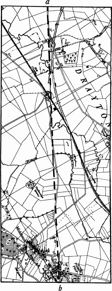
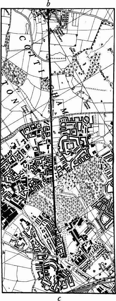
Fig. 169 Roman Road 57a Middleton—Corby
57a (cont.) Corby – Stanion

570 Irthlingborough – Irchester
Fig. 170 Roman Roads
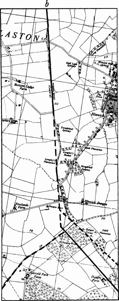
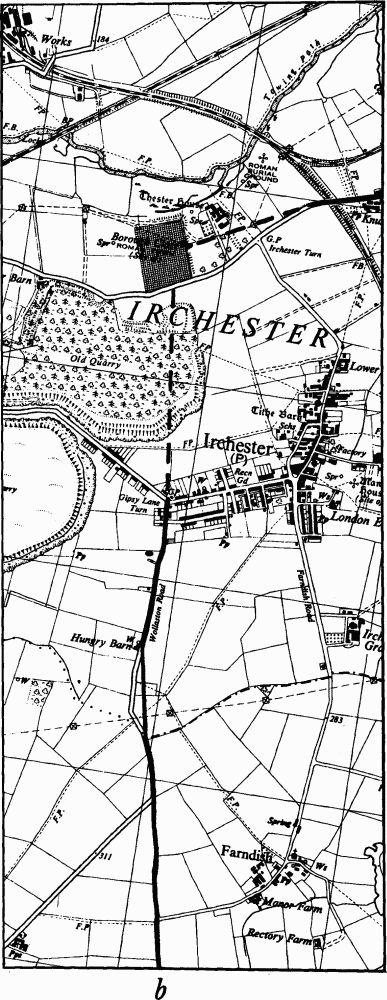
Fig. 171 Roman Road 170 Dungee Corner – Irchester