An Inventory of the Historical Monuments in the County of Northamptonshire, Volume 2, Archaeological Sites in Central Northamptonshire. Originally published by Her Majesty's Stationery Office, London, 1979.
This free content was digitised by double rekeying. All rights reserved.
'Corby', in An Inventory of the Historical Monuments in the County of Northamptonshire, Volume 2, Archaeological Sites in Central Northamptonshire, (London, 1979) pp. 23-26. British History Online https://www.british-history.ac.uk/rchme/northants/vol2/pp23-26 [accessed 11 May 2024].
"Corby", in An Inventory of the Historical Monuments in the County of Northamptonshire, Volume 2, Archaeological Sites in Central Northamptonshire, (London, 1979) 23-26. British History Online, accessed May 11, 2024, https://www.british-history.ac.uk/rchme/northants/vol2/pp23-26.
"Corby", An Inventory of the Historical Monuments in the County of Northamptonshire, Volume 2, Archaeological Sites in Central Northamptonshire, (London, 1979). 23-26. British History Online. Web. 11 May 2024, https://www.british-history.ac.uk/rchme/northants/vol2/pp23-26.
In this section
12 CORBY
(OS 1:10000 a SP 89 SE, b SP 88 NE, cSP 99 SW, d SP 98 NW)
The modern parish of Corby, covering some 2500 hectares, has been formed as a result of major boundary changes, consequent upon the development of the steel industry and its associated residential areas. As well as the medieval parish of Corby the area now includes most of the old parish of Great Oakley, parts of Cottingham and Weldon, and the former extra-parochial district of Beanfield Lawn (see (17)). Most of the parish lies on a flat Boulder Clay plateau, sloping gently S.E. between 107 m. and 130 m. above OD. This is cut by a series of small streams draining E. and N.E., in the valleys of which occur outcrops of limestones and marls. In spite of largescale ironstone-mining relatively little archaeological material has been found, but fieldwork carried out during the more recent residential development has produced a significant amount of evidence for prehistoric and Roman occupation. This perhaps indicates how much material has been destroyed without record during ironstoneworking. Recent finds, listed as separate monuments (2–14), may be fragments of a single large Roman occupation area and of its Iron Age precursors.
Prehistoric and Roman
A Palaeolithic handaxe, unrolled, is said to have been found at Corby, but this is doubtful (OS Record Cards). A small flint laurel-leaf point was found in 1973 in the S.W. of the parish (SP 858870; NM) and two sherds, one probably from a Beaker, and another decorated with twisted-cord impressions from a Beaker or Collared Urn, were discovered near by (SP 857685) at the same time (Northants. Archaeol., 9 (1974), 84). An Iron Age gold stater of the Brigantes, Mack 457, was found somewhere between Kettering and Corby before 1900 (NM; Brit. Num. J., 21 (1931–3), 5; VCH Northants., I (1902), 154–5).
d(1) Bronze Age Burials (centred SP 904893; Plate 31), in the area of the present steel works, were found in 1890 during ironstone-mining in the valley of a small brook, at 98 m. above OD. A contracted inhumation burial, accompanied by a bronze knife and parts of six urns, is recorded. The knife is in NM, together with two Collared Urns, both of the Primary Series listed as 'from Corby', and another, also one of the Primary Series listed as 'from Weldon', In addition there is another Collared Urn in NM which is definitely from this site (VCH Northants., I (1902), 142; NM Records; OS Record Cards; PPS, 27 (1961), 296, Nos. 112–4). A miniature vessel of Wessex-type, described as a pygmy-cup 'from Weldon', and another plain Collared Urn (both in NM) were apparently found a little to the E. of the above, at the same time, in an area then part of Weldon parish (VCH Northants., op. cit., 142; T.J. George, Arch. Survey of Northants., (1904), 3, 20).
b(2) Iron Age Settlement (SP 863896), S. of Old Kings Wood, on Boulder Clay at 114 m. above OD. Limited excavation of shallow ditches and pits revealed by building work has led to the discovery of pottery dating from the 7th to the 4th century B.C. (Northants. Archaeol., 10 (1975), 149).
b(3) Iron Age Settlement (SP 861873), in the W. of the parish, on Boulder Clay at 122 m. above OD. Construction work in 1973 revealed an extensive area of pits, gullies and ditches, containing Iron Age pottery (Northants. Archaeol., 9 (1974), 84; NM).
b(4) Iron Age and Roman Settlement (SP 856868), in a situation similar to (3). Half a circular ditched enclosure, 19 m. by 17 m. internally, was excavated. No interior features were noted. The surrounding ditch was 1.4 m. deep and was dated to around the 2nd century B.C. A series of later ditches, of which one was certainly of Roman date, was also recorded (Northants. Archaeol., 10 (1975), 149).
ab(5) Iron Age and Roman Settlement (SP 872900), on the N. side of the town, on Boulder Clay at 128 m. above OD. Ditches and pits containing probable Iron. Age pottery, animal bones and burnt clay have been found. In the same area Roman pottery and burnt timber have also been discovered (BNFAS, 2 (1967), 9).
b(6) Iron Age and Roman Settlement (SP 867897), on Boulder Clay at 132 m. above OD. Pits, a ditch 100 m. long, and an almost complete ring of burnt stone and timber 2 m. in diam., as well as lines of burning, are recorded. A lump of iron from a crucible, a Roman axe, part of a quern, animal bones and Iron Age pottery were recovered (BNFAS, 4 (1970), 2–3).
b(7) Roman Settlement (SP 87778930), in Thoroughsale Wood, on Boulder Clay at 116 m. above OD. Roman pottery, including samian, and large slabs of limestone have been discovered here. In addition a Roman bronze bird standing on a ball, probably from a lamp or a piece of domestic furniture, has also been found (BNFAS, 4 (1970), 59; J. Northants. Natur. Hist. Soc. and FC, 34 (1960), 64, 98–9; NM).
b(8) Roman Settlement (SP 856873), 500 m. W. of (3) in the W. of the parish, on Boulder Clay at 122 m. above OD. Construction work in 1973 revealed a series of pits and ditches. Surface finds included 2nd and 3rd-century Roman pottery and many worked flints (NM; Northants. Archaeol., 9 (1974), 91, listed under Middleton).
b(9) Roman Settlement (SP 856864) in the S.W. of the parish, on Boulder Clay at 112 m. above OD. Large quantities of Roman pottery of the 1st and 2nd centuries were found in 1973 during house building (NM; Northants. Archaeol., 9 (1974), 91).
b(10) Roman Settlement (?) (SP 88588875), in Montrose Street, on Boulder Clay at 107 m. above OD. Roman pottery, including samian, and animal bones have been found (BNFAS, 4 (1970), 59; OS Record Cards; KM).
b(11) Roman Settlement (centred SP 860870), covers 50 hectares in and around the Beanfield Estate, on Boulder Clay at 122 m. above OD. Roman material has been found at various times over a wide area during building construction. It includes the following:
(a) at SP 863878, a ditch, traceable for about 15 m., containing Roman pottery and animal bones associated with occupation debris including flue tiles, roofing tiles, iron slag and nails as well as one coin. Further N. shallow gullies and some depressions containing Roman pottery are recorded.
(b) at SP 864880, a general scatter of Roman pottery. This coincides with a circular ditched feature visible on air photographs taken before building work (RAF VAP F21 540/RAF/1312, 0103–4).
(c) at SP 864881, a length of limestone slabs, 4 m. wide and at least 15 m. long, associated with Roman pottery.
(d) at SP 866882, Roman pottery and part of a quern.
(e) at SP 866879, Roman pottery.
(f) at SP 869881, Roman pottery, including samian.
(g) at SP 870877, Roman pottery, coinciding with a group of indeterminate cropmarks visible on air photographs taken before building work. A D-shaped enclosure and two parallel ditches can be seen (RAF VAP F21 540/RAF/1312, 0103–4).
(h) at SP 866875, Roman pottery.
(i) at SP 876878, Roman pottery.
(j) at SP 86518820, a Roman quern.
(k) at SP 865881, Roman pottery.
(l) at SP 865879, Roman pottery (BNFAS, 3 (1969), 9; 4 (1970), 11, 58–9; NM).
a(12) Roman Settlement (SP 88149039), in Maple Grove, on Boulder Clay at 122 m. above OD. A large amount of Roman pottery, five Roman coins, and a hollowed stone, possibly a pivot, are recorded (OS Record Cards).
b(13) Roman Buildings (SP 887869), on Boulder Clay at 114 m. above OD. An aisled barn, 37 m. long, was excavated in 1955–6. It was timber-framed but had stone foundations, and was occupied around 100–150 A.D. In the second half of the century a roughly circular hut, 5 m. in diam., was built over the S.W. corner of the barn. The floor contained broken quern stones as well as pottery and ironwork. Three infant burials were also discovered (JRS, 56 (1966), 207; 57 (1967), 186; MOPBW, Arch. Excavations 1965 (1966), 11).
b(14) Roman Building (?) (SP 86158590), on Boulder Clay, at 99 m. above OD. There are unsatisfactory reports of a building which is said to have been found here (NM Records).
b(15) Roman Settlement (?) (SP 867864), on Boulder Clay at 107 m. above OD. Roman pottery, pits and ditches are recorded here (inf. P. Foster).

Fig. 30 Corby (17) Moat
d(16) Roman Pottery Kilns (SP 90608902), on Boulder Clay at about 100 m. above OD. During ironstone-mining in 1902 a brick-lined kiln was dis covered. A second kiln, and a bowl of Nene Valley type, as well as fragments of other kilns, were found in the following year. The first kiln was removed and is now in NM (J. Northants. Natur. Hist. Soc. and FC, 2 (1902), 263; OS Record Cards; NM).
For Roman Road 57a, see p. 186.
Medieval and Later
A silver penny of Stephen (1115–1159) has been found at SP 875905 (NM Records).
b(17) Moated Site (SP 86288806; Fig. 30; Plate 19), surrounds the 17th-century house known as Beanfield Lawn, on Boulder Clay at 126 m. above OD. The site was apparently a moated lodge belonging to one of the Forest Officers of Rockingham. The site and its surrounding land, known as The Lawn, were apparently considered to be a detached part of the parish of Benefield in the medieval period. On a map of 1580 (NRO) the moat is depicted as complete, within a paled or fenced enclosure of some 130 hectares. The present CottinghamKettering Road then passed to the E. of the site. The E. part of this area has been built over and its boundaries destroyed. The W. half survives but the present hedges appear to be relatively recent and almost purely of thorn. The map also indicates the extent of the original 'Lawn' within Rockingham Forest. The 17th-century economy of the Lawn is well recorded (P.A.J. Pettit, 'The Royal Forests of Northamptonshire', Northants. Record Soc., XXIII (1968), 150–1).
The moat once consisted of an almost square island, 40 m. by 45 m., surrounded by a wide, wet ditch. On the N. side the ditch has been filled in and no trace remains. The W. ditch is visible only as a slight depression. The S. and E. ditches are intact, 10 m. wide and 1.5 m. deep, and still hold water. There is a large external bank or dam on the S. side (J. Bridges, Hist. of Northants., II (1791), 395; VCH Northants., III (1930), 212).
b(18) Fishpond (SP 866859), immediately W. of Marsh Farm, Great Oakley, in the valley of a small E.flowing stream, on clay at 91 m. above OD. It is rectangular, 100 m. by 10 m., and 1.5 m. deep (CUAP, AXS 67; RAF VAP F21, 82/RAF/865, 0239–40).
b(19) Settlement Remains (SP 870856), formerly part of Great Oakley village, on the E. side of the Harper's Brook in Oakley Hall Park, on limestone at 90 m. above OD. The remains consist of a series of embanked closes extending from the road on the S. to the stream, with disturbed areas, presumably the sites of former buildings, at their S. ends. Two houses are shown here on a map of 1744 (NRO), but empty closes also marked on the map, as well as the existing earthworks, indicate that there were once at least two other houses.
(20) Cultivation Remains. The common fields of the parish of Corby were enclosed in 1830. Maps of 1616, 1733 and 1740 (NRO) all show the same basic layout of these fields in the centuries before enclosure. There were four main fields called North, South, East and West, arranged around the old village and largely enclosed by woodland. To the N. was another field almost separated from the rest by woodland and also called North Field on the 1733 map. Ridge-and-furrow of these fields exists on the ground or can be traced from air photographs in only a few places, as the modern development of Corby has removed most of the remains. It is visible W. of the old village centre (at SP 888892 and 889886) formerly in West Field, and S. of the old village (at SP 895881) formerly in South Field. It can also be traced towards the N. boundary of the town (at SP 880900) which was once part of the separate North Field.
The date of enclosure of the common fields of the old parish of Great Oakley, now part of Corby, is not known. Certainly by 1744 (NRO, Map of Great Oakley) all that part of the parish W. and N. of the village was already enclosed. There were also at that time two large enclosed areas called Colliers Field and Arbor Field E. and N.E. of the village. S.W. and S. of the village in the area now largely in Newton Parish were three open fields, North, South and East. Ridge-and-furrow of these latter three fields exists on the ground or can be traced on air photographs and most of the original pattern is recoverable. It is almost all end-on furlongs with ridges running across the contours, except for two narrow furlongs in the valley of the Harper's Brook which lie parallel to the stream. This is unusual. Ridge-and-furrow also exists N.W., N. and N.E. of the village in areas already enclosed in 1744. To the N.E. of the village it is almost totally recoverable and is arranged in a complex pattern of interlocked and end-on furlongs of radiating form. This appears to be due entirely to the necessity of ensuring that the ridges should run across the contours in an area of broken ground. In the far N.E. of the old parish (SP 885861) ridge-and-furrow also exists in fields called Benty Cops in 1744, probably indicating the existence of former woodland here. The same feature extends E. into the old parish of Little Oakley (see Newton (12)). (RAF VAP F21 82/RAF/865, 0239–45, 4086–7; F21 540/RAF/1312, 0091–7; F22 540/RAF/1312, 0089– 97; 541/612, 3043–54, 3063–70, 4044–52, 4086–7).
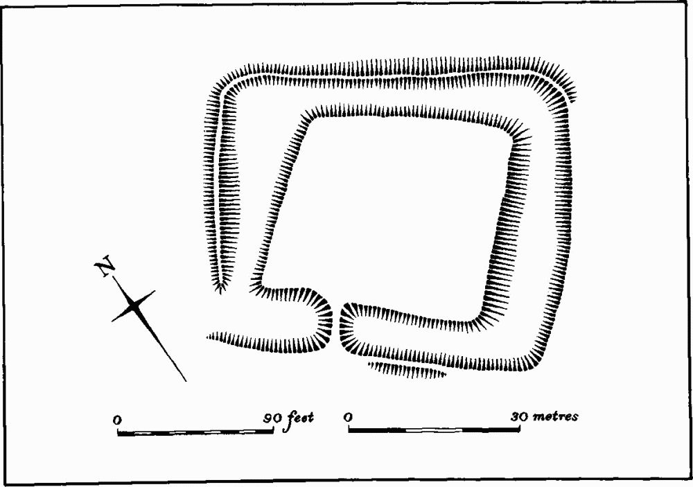
Fig. 31 Cottingham (2) Moat
Undated
b(21) Enclosure (SP 875879), lay on the S. side of what is now Gainsborough Road, on Boulder Clay at 107 m. above OD. The site has been entirely destroyed, but air photographs taken in 1953 and 1954 (RAF VAP F21 540/RAF/1312, 0104–5; F22 58/RAF/1210, 0022) show a rectangular embanked enclosure with an external ditch, 60 m. long and 40 m. wide, orientated roughly E.–W. There was no trace of an entrance. The interior appears to have been occupied by a large circular feature 25 m. in diam.