An Inventory of the Historical Monuments in the County of Northamptonshire, Volume 2, Archaeological Sites in Central Northamptonshire. Originally published by Her Majesty's Stationery Office, London, 1979.
This free content was digitised by double rekeying. All rights reserved.
'Brafield-on-the-Green', in An Inventory of the Historical Monuments in the County of Northamptonshire, Volume 2, Archaeological Sites in Central Northamptonshire, (London, 1979) pp. 5-9. British History Online https://www.british-history.ac.uk/rchme/northants/vol2/pp5-9 [accessed 24 April 2024]
In this section
4 BRAFIELD-ON-THE-GREEN
(OS 1:10000 a SP 86 SW, b SP 85 NW)
The parish occupies a long narrow strip of land, immediately S. of the R. Nene, covering 534 hectares. The S. half lies on a generally flat, Boulder Clay table-land at about 107 m. above OD, cut into by a series of narrow, steep-sided valleys. In the N. the land falls sharply across outcrops of limestone, sand and clays to the R. Nene, here flowing at about 50 m. above OD. The land around and to the E. of the village is remarkable for the large number of prehistoric and Roman settlements which have been found there, including a number of Roman pottery kilns. The village is of some interest in that surviving earthworks perhaps indicate a general movement of the village southwards on to a former large, open green. The shape of the parish and the fact that its common fields were intermixed with those of Little Houghton suggest that the two parishes were once one unit (VCH Northants., IV (1937), 229).
Prehistoric and Roman
A stone axe is reputed to have been found N.W. of the church (SP 821592) many years ago (lost; NM Records). Worked flints have been picked up on many of the sites listed below. Others have been found at SP 81826048 (BNFAS, 6 (1971), 3, Brafield (1)).
b(1) Round Barrow (?) (SP 81595904), close to the parish boundary and N. of the village, on Boulder Clay at 97 m. above OD. A low mound survives, some 60 m. in diam. but only 0.3 m. high, with traces of an outer ditch. It has been ploughed over. A flint scraper has been found on the site (NM Records).
b(2) Ring Ditch (SP 82775991; Fig. 19), in the N.E. of the parish on limestone at 91 m. above OD. It is some 20 m. in diam. with an eccentric pit (air photographs in NMR). It may be associated with the settlement (20) to the E. of the trackway and other cropmarks to the W. (11).
b(3) Ring Ditch (SP 82655975; Fig. 19), 200 m. S.W. of (2), on Boulder Clay at 95 m. above OD. Air photographs (in NMR) show a ring ditch 15 m. in diam. with a short length of ditch to the N. which may be associated with other ditches to the N. again (11).
b(4) Ring Ditch (SP 82395933; Fig. 19), 320 m. N.E. of the church, on Boulder Clay at 99 m. above OD. Air photographs (in NMR) show a ring ditch 27 m. in diam. with a short length of ditch attached to its S.E. side.
b(5) Ring Ditch (SP 82955896; Fig. 19), E. of the village, on the N.W. side of a valley, on limestone at 97 m. above OD. Air photographs (in NMR) show cropmarks of a ring ditch 22 m. in diam. with a well-marked central pit or grave.
b(6) Ring Ditch (SP 83085889; Fig. 19), 130 m. S.E. of (5), in a similar position at 91 m. above OD. Air photographs (in NMR) show a ring ditch about 30 m. in diam.
b(7) Ring Ditch (SP 82805893; Fig. 19), 130 m. W. of (5), on limestone at 99 m. above OD. Air photographs (in NMR) show a ring ditch 18 m. in diam.
b(8) Ring Ditch (SP 82765887; Fig. 19), 190 m. S.W. of (5), on glacial gravel at 97 m. above OD. Only the N. half of what is presumably a ring ditch is visible on air photographs (in NMR). Worked flints have been found nearby (BNFAS, 6 (1971), 4, Brafield (11)).
b(9) Ring Ditch and Iron Age Settlement (SP 82585917; Fig. 19) N.E. of the village, on Boulder Clay and gravel at 100 m. above OD. The ring ditch, visible indistinctly on air photographs (in NMR), has a diam. of 20 m. In the same area finds include leaf-shaped arrowheads, a barbed-and-tanged arrowhead, other worked flints, Iron Age pottery and animal bones, associated with circular patches of dark soil, possibly pits. A Roman coin and a Roman bronze pin have also been found here (BNFAS, 3 (1969), 20; 4 (1970), 6; 6 (1971), 4, Brafield (8); 7 (1972), 13).
b(10) Bronze Age Burial (?) (SP 83275890; Fig. 19), in the E. of the parish on the side of a small valley, on limestone at 88 m. above OD. Sherds thought to be from a Bronze Age incense cup, with a flint knife and a scraper, were found in a dark patch of soil (BNFAS, 6 (1971), 4, Brafield (9)).

Fig. 19 Brafield-On-the-Green (2–8) Ring ditches, (10) Bronze Age burial, (9, 13, 15–17, 19) Iron Age settlements, (14, 20) Iron Age and Roman settlements, (11, 12) Cropmarks, (27, 28) Roman kilns
b(11) Ditched Trackway and Ditches (SP 824596–826598; Fig. 19), W. of (2) and N. of (3), on limestone at 91 m. above OD. Air photographs (in NMR) show indistinctly what appears to be a ditched trackway running N.E.–S.W. with a number of indeterminate ditches lying immediately E. of the N.E. end.
b(12) Enclosure (SP 82535960; Fig. 19), due E. of the S.W. end of the ditched trackway (11), on lime-stone at 96 m. above OD. Air photographs (in NMR) show a roughly circular enclosure, 20–25 m. in diam., with a funnel-shaped entrance on the S.E. side.
b(13) Iron Age Settlement (SP 828594; Fig. 19), on Boulder Clay at 104 m. above OD. Air photographs (in NMR) show a series of indistinct cropmarks of no coherent form. Iron Age pottery has been found here (BNFAS, 4 (1970), 2; 6 (1971), 4, Brafield (6)).
b(14) Iron Age and Roman Settlement (SP 826595; Fig. 19), 200 m. W. of (13) in a similar situation. Iron Age and Roman pottery, including samian, animal bones and pieces of bronze slag have been found (BNFAS, 6 (1971), 4, Brafield (7)). Immediately to the S. (at SP 826594) air photographs (in NMR) show a circular enclosure with a wide, out-turned entrance on the N.E. A sinuous ditch attached to the N. side is also visible. Further S. again (at SP 826593) a Roman coin of the late 3rd century, a barbed flint arrowhead and a coin of Edward IV (1465–6) are recorded (BNFAS, 3 (1969), 20; 4 (1970), 6).
b(15) Iron Age Settlement (?) (SP 834597; Fig. 19), in the extreme N. of the parish, on Boulder Clay and gravel at 100 m. above OD. Iron Age pottery and worked flints have been found, associated with dark areas of soil. Worked flints and samian pottery have also been found in the adjacent field to the S.W. (BNFAS, 6 (1971), 4, Brafield (5); NM Records).
b(16) Iron Age Settlement (SP 82955901; Fig. 19), immediately N. of (5), on sand and gravel at 99 m. above OD Finds have included worked flints, animal bones and fire-blackened pebbles, associated with a scatter of stone and lines of ditches which appear in the plough soil. Iron Age pottery, including a near-complete bowl, was discovered in the excavation of a shallow ditch (BNFAS, 6 (1971), 4, Brafield (10)).
b(17) Iron Age Settlement (?) (SP 829588; Fig. 19), 200 m. S.S.W. of (16) on sand at 92 m. above OD. Pits or ditches have been noted on the surface here and some Iron Age pottery was discovered in the spoil heaps of a pipeline trench cut across the area in 1960 (BNFAS, 1 (1966), 6).
b(18) Iron Age Settlement (SP 828584; Fig. 35), on both sides of the main A 428 road, S.E. of the village, on Boulder Clay at 99 m. above OD. Air photographs (in NMR) show a large rectangular enclosure with a group of irregular ditches and enclosures attached to it on the N.W. Pits and ditches containing Iron Age pottery have been noted on the ground around and to the S. of these cropmarks, and a bone needle (NM) and a possible loom weight have also been discovered (BNFAS, 6 (1971), 4, Brafield (15)).
b(19) Iron Age Settlement (?) (SP 831586; Fig. 19), 350 m. N.E. of (18), on Boulder Clay at 99 m. above OD. Iron Age pottery, associated with iron slag and one sherd of samian ware, has been found (BNFAS, 6 (1971), 4, Brafield (12)).
b(20) Iron Age and Roman Settlement and Kiln (SP 828599; Fig. 19), close to the N. parish boundary, on limestone and clay at 91 m. above OD. Finds made in the area include part of a polished flint axe, worked flints, late Iron Age pottery, Roman pottery, fire bars, a bronze pin, two brooches and other bronze objects, and a glass bead (BNFAS, 6 (1971), 3–4, Brafield (4); Northants. Archaeol., 8 (1973), 5). Excavation in 1960 on a pit showed that it contained Roman kiln debris (Ant. J., 49 (1969), 94). Air photographs (in NMR) show a number of indistinct cropmarks in the area, including a sub-rectangular enclosure.
b(21) Iron Age and Roman Settlement and Kiln (SP 819581), S. of the village, on Boulder Clay at 100 m. above OD. Finds include worked flints, animal bones, late Iron Age pottery, Roman pottery and coins of the 1st to 4th centuries, bone objects, a bronze buckle and bell, iron nails, an iron chain, a glass bead and querns. Roman roof and flue tiles and a scatter of limestone have also been recorded. Small-scale excavations have revealed a stone wall, ditches, pits (one of which contained kiln-lining, bars and wasters), a hearth and a kiln, as well as slag and coal. Large quantities of iron slag cover the area. An iron-working site, as well as pottery kilns, is indicated (BNFAS, 3 (1969), 6; (1971), 4, Brafield (17); Ant. J., 49 (1969), 94).
b(22) Iron Age and Roman Settlement (SP 824584), S.E. of the village, on Boulder Clay at 99 m. above OD. Ditches and pits containing Iron Age and early Roman pottery were noted here in 1966 when a pipeline crossed the area, and part of a human skull was recorded (BNFAS, 1 (1966), 14; 6 (1971), 4, Brafield (13)).
b(23) Iron Age and Roman Pottery (SP 826586), 200 m. N.E. of (22). Small quantities of Iron Age and Roman pottery have been found here at various times (BNFAS, 1 (1966), 5–7; 2 (1967), 7;6 (1971), 4, Brafield (14)).
b(24) Iron Age and Roman Pottery (centred SP 818576), in the S.W. of the parish, on Boulder Clay at 107 m. above OD. Small quantities of Iron Age pottery have been found here, as well as Roman pottery further E. at SP 820576 (BNFAS, 6 (1971), 4, Brafield (18)).
b(25) Iron Age and Roman Pottery (SP 827573), in the S.E. of the parish, on Boulder Clay at 107 m. above OD (OS Record Cards).
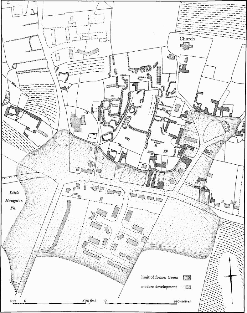
Fig. 20 Brafield-On-The-Green (32) Settlement remains
b(26) Iron Age and Roman Settlement (centred SP 826568), in the S.E. of the parish, on Boulder Clay at 91 m. above OD. At SP 827568 patches of stone associated with Iron Age pottery were noted in 1963. Subsequent trial excavation located a ditch containing more Iron Age pottery and animal bones. At SP 825567 Roman pottery of the 1st to 4th centuries, roof tiles, worked flints, animal bones and one coin have been discovered with an area of limestone rubble. A small cobbled area has been excavated (BNFAS, 6 (1971), 4–5, Brafield (19) and (20); OS Record Cards).
a(27) Roman Kilns (SP 824601; Fig. 19), in the N. of the parish, on clay and limestone, at 91 m. above OD. Roman pottery and worked flints have been discovered over a wide area. Excavations in 1963 across a ditch produced more pottery and a brooch, both of the 1st century, animal bones and kiln bars (NM; BNFAS, 6 (1971), 3, Brafield (2); Ant. J., 49 (1969), 94).
b(28) Roman Kilns (SP 823598; Fig. 19), 250 m. S.S.W. of (27) and in a similar situation. Roman pottery, a glass bead, kiln bars and kiln-lining have been found (BNFAS, 6 (1971), 3, Brafield (3); Ant. J., 49 (1969), 94).
b(29) Roman Settlement and Kilns (centred SP 817594), immediately W. of Lower End, on Boulder Clay at 99 m. above OD. Roman pottery and worked flints have been found over an area of 50 sq. m. A pit filled with rubbish, including kiln debris, is recorded (SP 818599). A Mesolithic-type core is also recorded from here (BNFAS, 4 (1970), 2; 6 (1971), 4, Brafield (16); OS Record Cards; Ant. J., 49 (1969), 94).
b(30) Cropmarks (?) (SP 821585), S. of the village, on Boulder Clay at 100 m. above OD. Ditches and pit alignments are said to have been seen from the air here. A Roman coin has been found on the site (OS Record Cards).
Medieval and Later
A small lead ampulla or flask was found in the parish in 1966. It is identical to one (in NM) from the site of Northampton Castle (BNFAS, 2 (1967), 22).
b(31) Medieval Pottery and Fire-Cover (SP 82125880), found at the W. end of the village during trenching work in 1961. Medieval pottery and a fine example of a pottery fire-cover of the 10th or 11th century were discovered within a pit (BNFAS, 6 (1971), 5, Brafield (21); J. Northants. Mus. and Art Gal., 6 (1969), 51–3).
b(32) Settlement Remains (centred SP 821589; Fig. 20), lie in the centre of the present village, immediately S.W. of the church, on Boulder Clay at 107 m. above OD. Before the early 19th century the village of Brafield lay on the N. side of a large, irregular green, which was roughly bisected by the NorthamptonBedford Road (A 428). The green was enclosed at the same time as the common fields, by Act of Parliament in 1827 (NRO, Enclosure Map, 1829). Some encroachment had taken place before enclosure and shortly afterwards other houses were erected on the N. side of the former green. In recent years modern housing estates have been built over much of the S. part.
The remaining earthworks between the green and the church are very slight and form no overall pattern. However a series of rectangular paddocks, bounded by scarps and banks all under 0.5 m. high, are visible, as well as a number of platforms, probably the sites of former buildings. To the N.W. of these, on the W. side of the Billing Road (SP 818590), between Home Farm and the separate part of the village known as Lower End, is a series of long closes, bounded by scarps up to 0.5 m. high. These are also perhaps the remains of former houses and gardens. All the remains had been abandoned by 1829 (Enclosure Map; RAF VAP CPE/UK/1926, 4013–4; FSL 6565, 1856–7).
(33) Cultivation Remains. The common fields of the parish were enclosed by Act of Parliament in 1827 (NRO, Enclosure Map, 1829), together with those of Little Houghton. In the early 18th century Bridges recorded that the common fields of the parishes were intermixed (J. Bridges, Hist. of Northants., I (1791), 341). Ridge-and-furrow of these fields remains on the ground or can be traced on air photographs in a number of places, though the pattern is not complete. The ridgeand-furrow that does survive appears to agree with the furlong boundaries and access-ways shown on the Enclosure Map. It is arranged in end-on and interlocked furlongs of reversed-S or C-curved form. A few former headlands remain on the ground, as ridges 10 m. –15 m. wide and traceable for up to 225 m. One of these, in the S. of the parish (at SP 819576), lying between two end-on furlongs, was also an access-way from the village. In the extreme S. of the parish was an area of wasteland, called The Furze in 1829, and in the early 18th century (Bridges, op. cit.). However, traces of ridge-and-furrow are visible here (e.g. at SP 827571), indicating former cultivation of the area at some time. Ridge-and-furrow in areas which were old enclosures around the village in 1829 still survives around Home Farm (SP 818589) and N. of Lower End (SP 820595). It is arranged in curving furlongs and is indistinguishable from the common-field ridge-and-furrow (RAF VAP CPE/UK/1926, 2014–5, 4011–5/1994, 1190–3, 2186–8, 3180–3; F21 543/ RAF/943, 0052–6; F22 543/RAF/943, 0054–6; F21 543/RAF/2409, 0153–5; F22 543/RAF/2409, 0153–6).