An Inventory of the Historical Monuments in the County of Northamptonshire, Volume 3, Archaeological Sites in North-West Northamptonshire. Originally published by Her Majesty's Stationery Office, London, 1981.
This free content was digitised by double rekeying. All rights reserved.
'Watford', in An Inventory of the Historical Monuments in the County of Northamptonshire, Volume 3, Archaeological Sites in North-West Northamptonshire, (London, 1981) pp. 188-193. British History Online https://www.british-history.ac.uk/rchme/northants/vol3/pp188-193 [accessed 25 April 2024]
In this section
62 WATFORD
(OS 1: 10000a SP 56 NE, b SP 57 SE, c SP 66 NW, d SP 67 SW)
The parish, covering more than 1400 hectares, is of irregular shape with a number of projections. A small part of its S.W. boundary follows the A5, Watling Street, but further N. the parish extends W. across the Roman road. The E. boundary is determined by the upper reaches of a small stream flowing S. towards the R. Nene. The valley known as the Watford Gap, carrying the main road, rail and water routes of central England, runs through the W. half of the parish; from its alluvial floor, at about 100 m. above OD, the land rises steeply to the W. across glacial deposits to a maximum height of 135 m. above OD and more gently to the E. across Lias Clays and Marlstone Rock capped by glacial materials.
The modern parish now contains the land of at least two deserted settlements, Silsworth (3) and an unnamed and unlocated settlement (2), as well as that of the village of Watford itself and part of the land of a fourth settlement, Murcott (Long Buckby (5)). The sites of Silsworth and Murcott are known with certainty. The village of Watford has extensive settlement remains (4), bearing witness to an earlier form of the village; there are also remains of a garden perhaps constructed in the 18th century (5).
Roman
d(1) Roman settlement (?) (centred SP 616707), at the site of the deserted village of Silsworth (3). A small amount of Roman pottery was found in an unspecified place during an excavation in 1964 (Med. Arch., IX (1965), 214). In 1977 more Roman pottery was picked up on the N. and W. edges of the site (SP 615707, 617708).
Medieval and Later
a(2) Settlement remains (unlocated but perhaps SP 578695, 580695 or 585697; Fig. 99), lie somewhere in the extreme W. of the parish to the W. of Watling Street. The small triangular area of the parish which extends to the W. of Watling Street is unusual. Parish boundaries in this area generally cross the Roman road only to incorporate within their area land which was once a separate estate based on a medieval settlement (e.g. Norton (11)). Thus there are some grounds for assuming that this area was once the land of a now deserted settlement. In addition, as well as the other known settlements and estates in the parish, Silsworth (3) and Murcott (Long Buckby (5)), there are records of at least two other places both described by Bridges as deserted in the 18th century. One was called Catesby, 'an enclosed manor with no house', the other, Cumberford, 'a depopulated village in an enclosed manor, now reduced to one house ... the Crown ale house' (J. Bridges, Hist. of Northants., I (1791), 585). The locations of both are unknown, but one may have been situated in the area under discussion. There are three possible sites. One is on the N. side of a small E.-flowing stream (SP578695), on the road between Crick and Ashby St. Ledgers. A broad flat area bounded by scarps up to 2 m. high has slight traces of ridge-and-furrow on it. Another is further N.E. (sp 580695), on a steep S.-facing slope to the N. of the railway cutting leading into Kilsby Tunnel. There are at least three small closes, bounded by low scarps; the S. ends have been truncated by the railway. The third possible location is further E., S. of Watford Gap (SP 585697). The field here is called Moat Close on a map of 1764 and Mott Close Meadow on the Tithe Map of 1847 (both in NRO). Near its N.E. end there is a large quarry-pit, associated with a number of indeterminate banks or scarps and surrounded by ridge-and-furrow.
d(3) Deserted village of Silsworth (SP 617707; Figs. 99 and 141; Plates 12 and 13), lies in the N.E. corner of the parish on both sides of a small valley draining S.E., on glacial sands and gravels at about 140 m. above OD. The history of Silsworth is largely unknown, although the land attributable to it can be defined with some certainty (Fig. 99). The village is not mentioned in Domesday Book, though it presumably existed at that time, and is probably included silently under Watford. The name is not recorded until 1213 (PN Northants., 75). In 1333 Silsworth is referred to as a hamlet and in 1392 there were said to be several tenements. By the early 15th century one freeholder family had accumulated most of the land in Silsworth from a variety of earlier holders. This and other properties in Silsworth were acquired by the Catesby family later in the 15th century and by 1485 the land of Silsworth was said to consist of 300 acres arable and 490 acres pasture. In 1594 the land was divided into three 'closes or pastures' called Middle Field, High Field and Sharrocks Close (K. J. Allison et al., The Deserted Villages of Northants. (1966), 45). On a map of 1631 (PRO; Plate 13), the Middle Field is depicted lying on either side of the present road to West Haddon immediately S. and E. of the site of the village. The map also shows a meadow to the S.W. and includes the S. part of the site of the village. However only three buildings are shown, one house on the site of the existing cottage now known as Kelly's Rise, another building to the N., near the ruined farm buildings, and a third house, to the S.W. of the village proper, on the S. side of the stream. By the early 18th century Bridges (Hist. of Northants., I (1791), 585) described Silsworth as 'a depopulated hamlet consisting at present of a single house', the latter presumably the one shown on the site of the existing cottage.
The remains of Silsworth are in poor condition and over half the site has been ploughed in recent years and almost destroyed. As a result it is difficult to interpret what remains. As far as can be seen the village stood at a cross-roads which lay immediately S. of the present cottage. Here the Watford-West Haddon road, which at this point seems to be on its medieval alignment, is crossed by a hollow-way ('a'–'b'–'c'–'d' on plan). This hollow-way approaches the site from the S.E. ('a' on plan) and though much damage appears to have crossed the present road, swung to the W. of the cottage ('b' on plan) and then run on N. and N.E., across an area now under arable, until it fades out ('d' on plan). Another hollow-way seems to have run N.W. from the present road near the stream, along the bed of the latter ('e'–'f' on plan). There is no indication of a road there, but the arrangement of the closes on either side of the stream suggest that this was the case. Traces of closes and former buildings lie on either side of both these hollow-ways though recent destruction as well as earlier damage has now removed most of the evidence. To the N. of the S.E. hollow-way is an area of disturbed ground ('g' on plan) very difficult to interpret. A markedly sinuous ditch appears partly to divide some possible building sites from the adjacent ridge-and-furrow. To the S. of the hollow-way ('h' on plan) nothing survives apart from two rectangular depressions up to 1.5 m. deep and some indications of old quarrying. The area to the N. of Kelly's Rise, E. of the hollow-way ('c'–'d' on plan), has been ploughed in recent times and little remains on the ground though there are traces of possible house-sites. After ploughing, large quantities of medieval pottery, mainly of 12th to 14th-century date, were recovered from here, and considerable spreads of stone rubble were also noted. Closes and former house-sites exist or existed on both sides of the other hollow-way ('e'–'f' on plan). Those on the W. have been largely destroyed by modern cultivation but there appear to have been at least eight closes, separated by shallow ditches, with house-sites at their E. ends. Here again large amounts of medieval pottery have been found. On the E. side of this hollow-way the earthworks are intact and appear to be the remains of five closes. No certain building sites are visible though a number of flat, raised platforms to the W. of the cottage may mark the positions of former structures.

Fig. 141 Watford (3) Deserted village of Silsworth
A small excavation on the site in 1964 when it was already partly destroyed revealed a 'medieval occupation-layer' below which were several road surfaces of hard metalling. Two courses of a medieval stone wall lay at right-angles across the topmost road surface (Med. Arch., IX (1965), 214). The location of this excavation is not recorded and that given by the OS Record Cards, at SP 61847056, puts it outside the village in an area of ridge-and-furrow. In NM is a small quantity of pottery from Silsworth. It includes one rim sherd of Ipswich ware, two sherds of Stamford ware and later medieval and post-medieval pottery (Northants. Archaeol., 8 (1973), 19; 12 (1977), 191; RAF VAP CPE/UK/1994, 1474–5; CUAP, AWQ15, 16).
c(4) Settlement remains (centred SP 601688 and 602691; Figs. 13, 99 and 142; Plate 20), lie in two places N.W. and S.W. of Watford Church, on land sloping W. on Middle Lias clays and silts between 110 m. and 125 m. above OD. Part of the site is overlaid by the later garden remains (5).
The earthworks may be interpreted as two separate settlements, related to two road systems, though it is difficult to find documentary support for this theory. Watford is first mentioned in Domesday Book where it is listed as a single two-hide manor with a recorded population of 27 (VCH Northants., I (1902), 355). However, this entry must refer not only to Watford itself, but also to the now deserted village of Silsworth (3), perhaps to the part of the hamlet of Murcott lying within the parish (Long Buckby (5)) and to at least one other settlement (2). Thus the 1086 population figures have little value, and the later national taxation records are similarly limited in their usefulness. By the early 18th century Bridges (Hist. Of Northants., I (1791), 585) noted that there were 35 houses in Watford, apparently in the present village, but he also records four other places in the parish. These include Murcott and Silsworth, but in addition there was Catesby, 'an enclosed manor with no houses' and Cumberford, 'a depopulated village on an enclosed manor now reduced to one house'. One of these is likely to be the deserted settlement (2) in the W. of the parish, but the other is either lost or part of the earthworks described here.
The N. part of the remains lies alongside the road to Kilsby ('a' on plan). It consists, on the S. side of the road, of four or five small rectangular closes, bounded by low scarps or shallow ditches with what may be former house-sites at their N. ends. In the westernmost close, and lying askew to it, are the foundations of a rectangular stone building. Behind these closes, to the S., are four small paddocks, three of which have ridge-and-furrow within them. Traces of a hollow-way almost on the line of the present road are also visible. On the N. side of the road are at least three other small closes with slight indications of former buildings within them. It is possible that the site once extended further E. towards the village, but the area to the N. of the road has been ploughed and only slight scarps remain; on the S. the gardens of Watford Court have obliterated all traces. No date for the abandonment of this part of the village is known though it had certainly disappeared by 1740 (Map in NRO). It may be the site of one of the two deserted settlements referred to by Bridges (op. cit.).
The southern area of earthworks is larger and appears to be the remains of former houses and closes lying on either side of the present Main Street and its extension W. as Park Lane, as well as on the W. side of Station Road. On the S. side of Main Street, partly behind the existing houses, are at least six long closes bounded by low scarps and shallow ditches ('b' on plan). On a series of maps dating from 1771 to the Tithe Map of 1840 (all in NRO) most of these closes are shown as hedged paddocks, with houses at their N. ends. The earthworks therefore represent relatively recent abandonment of this part of the village. To the N.W., and inside the park of Watford Court ('c' on plan), is another series of closes, most of which are in a rather mutilated state. These closes were already abandoned by 1740 (NRO, Map of Watford Park), but houses which stood at their S. ends, along Main Street and Park Lane, were still there in 1771 and in 1840. This indicates that the houses along this street had their gardens taken away, perhaps in the early 18th century when the park was laid out and the gardens were incorporated into the park. The houses, however, survived until well into the 19th century and perhaps as late as 1860 when many new estate cottages were erected in the village. To the S. of Park Lane and W. of Station Road ('d' on plan) are further abandoned closes with a hollow-way running along their S.W. sides. These had already been made into one paddock in 1771 and a range of farm buildings stood within them. On the opposite side of Station Road ('e' on plan) an area of disturbed ground marks the site of another house and garden, in existence from at least 1771 to 1840 (RAF VAP 543/RAF/2337, 0377–9; CUAP, AW168, 75, 76, AWQ18, 19).
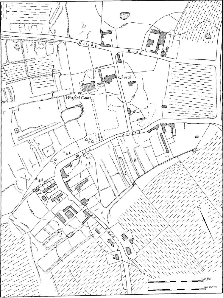
Fig. 142 Watford (4) Settlement remains, (5) Garden remains at Watford
c(5) Garden remains (SP 601690; Fig. 142; Plate 20), formerly belonging to the now demolished Watford Court, lie to the W. of the site of the house, on land sloping W. between 110 m. and 125 m. above OD. They cut into and partly destroy sections of the settlement remains (4).
Little is known of the history of the site, but the building that was demolished appears to have incorporated a considerable part of a house built in 1568 by Richard Burnaby; it was certainly added to in the 17th century and greatly restored and enlarged on more than one occasion in the 19th century. It was pulled down in about 1970. The earthworks lie beyond the 19th-century shrubberies round the house and outside a ha-ha marking the edge of the 19th-century formal garden. They consist of a broad, straight hollow-way or drive ('f' on plan), up to 2 m. deep, once lined with trees, the stumps of which still edge it. This hollow-way fades out as it reaches the level ground, but the avenue of trees clearly continued W. for some distance. At the E. end of the hollow-way and on either side of it, close to the house, are levelled platforms, bounded by scarps with double scarps on their steep W. sides. These may be garden terraces. To the S. of the southern platform there is a very large depression up to 3 m. deep, of unknown purpose. Near the W. end of the drive or hollow-way, and just to the N. of it, are the remains of two parallel embanked ponds, and further S. is a low square mound, only 0.25 m. high, which has slight ridges across it. The ground around it is much disturbed by later activities.
The earliest information concerning these remains is of the early 18th century; a very small-scale map in J. Morton's Nat. Hist. of Northants. (1712) shows a park occupying the area W. of Watford Court between Park Lane and the Kilsby road. No internal details are depicted, but it is possible that many of the earthworks are of this general period. The first detailed plan of the park is of 1740 (NRO). The plan is rather schematic, but shows a rigid formal layout which would seem to be of a period earlier than the 1740s. It may in fact depict in some detail the layout of the early 18th-century park which had survived until then. The plan shows two raised platforms W. of the house but their purpose is not indicated. The drive or hollow-way is also shown as are a number of rigidly geometric plantations. The small double pond at the W. end of the drive is marked and on the site of the small mound is another pond with two rectangular islands within it. The existing mound may therefore be one of these islands. Another pond, with a long mound within it, which still exists further N.W. (at SP 599692) is also shown on the 1740 plan, though there were then two islands.
For how long the park existed in this form is not clear, but by the early 19th century (OS 1st ed. 1 in. map (1834)) the park still retained its 1740 boundaries and its central avenue along the drive, though a new avenue had been made across the fields to the N. of the hall. Later in the 19th century, after 1840 (NRO, Tithe Map), a large extension was made to the park on either side of the new avenue N. of the Kilsby road. Nearer the hall a row of cottages along the N. side of Main Street were removed and replaced by a shrubbery (RAF VAP 543/RAF/2337, 0377–9; CUAP, AW168, AWQ18, 19).
(6) Cultivation remains (Plate 21). Part of the common fields of Watford were enclosed by an Act of Parliament of 1771 (NRO, Enclosure Map), but this involved less than half the parish, the area mainly S. of the village. The greater part of the parish was already in old enclosures at this time, some of which are shown on a map of 1780 (NRO). This enclosure was apparently carried out in 1644 by Sir George Clerke (J. Bridges, Hist. of Northants., I (1791), 585). The part of the parish W. of the Roman road (A5) was also enclosed by 1764 (Map in NRO). Ridge-and-furrow of the common fields survives on the ground or can be traced on air photographs throughout most of the parish and is arranged in end-on and interlocked furlongs. Much of it is strikingly well preserved, particularly round the village where it exhibits some unusual features. For example, to the N. of the garden remains (5) (SP 601693) the ridges are long and widely spaced with very narrow ridges between them (see Sectional Preface). S. of the village (SP 602683; Plate 21) some furlongs terminate in very large rectangular mounds lying on either side of a hollow-way which runs obliquely through the ridges. In that position these might be explained as unusually large terminations of the ridges but, if they are, then a further double row of mounds, close to the first, could not have been formed at the same time, as the intervening ridges would have been too short. No conclusive explanation of these features can be reached.
The common fields of the deserted village of Silsworth (3) were enclosed at an unknown date before 1594. A field to the E. of the village, known as Silsworth Middle Field, is shown on a map of 1631 (Map in PRO; Plate 13). Although much of the ridge-and-furrow of these fields has been destroyed it can all be traced from air photographs arranged in end-on and interlocked furlongs (RAF VAP CPE/UK/1994, 1357–65, 2356–7, 1473–80; 543/RAF/2337, 3073–7; CUAP AW173).