An Inventory of the Historical Monuments in the County of Northamptonshire, Volume 4, Archaeological Sites in South-West Northamptonshire. Originally published by Her Majesty's Stationery Office, London, 1982.
This free content was digitised by double rekeying. All rights reserved.
'Paulerspury', in An Inventory of the Historical Monuments in the County of Northamptonshire, Volume 4, Archaeological Sites in South-West Northamptonshire(London, 1982), British History Online https://www.british-history.ac.uk/rchme/northants/vol4/pp111-117 [accessed 30 April 2025].
'Paulerspury', in An Inventory of the Historical Monuments in the County of Northamptonshire, Volume 4, Archaeological Sites in South-West Northamptonshire(London, 1982), British History Online, accessed April 30, 2025, https://www.british-history.ac.uk/rchme/northants/vol4/pp111-117.
"Paulerspury". An Inventory of the Historical Monuments in the County of Northamptonshire, Volume 4, Archaeological Sites in South-West Northamptonshire. (London, 1982), British History Online. Web. 30 April 2025. https://www.british-history.ac.uk/rchme/northants/vol4/pp111-117.
In this section
46 PAULERSPURY
(OS 1:10000 a SP 74 NW, b SP 74 SW, c SP 64 NE)
The modern parish covers some 1200 hectares including the hamlet and land of Heathencote. The higher areas in the S. and W., rising to a maximum height of 123 m. above OD, are covered by Boulder Clay. From there the land slopes generally N.E., across bands of Oolitic Limestone exposed on the steep sides of small valleys, to the valley of the R. Tove here flowing at about 80 m. above OD in a flat-bottomed valley of Upper Lias Clay and alluvial deposits.
Two Iron Age and numerous Roman settlements (1–9) have been discovered in the parish and the settlement pattern of Paulerspury village (10–14) is also of considerable interest.
Prehistoric and Roman
The blade of a Mesolithic tranchet axe was found in 1977 (SP 70854757; NM; Northants. Archaeol., 13 (1978), 180).
There are unsatisfactory records of several Roman coins from the parish, for example a possible hoard including 'several medals of Constantine, Maximillian and other Roman emperors' (J. Morton, Nat. Hist. of Northants. (1712), 531; J. Bridges, Hist. of Northants., I (1791), 314). More recently a coin of Domitian has been found near the Roman road (SP 69924807; OS Record Cards), and an unspecified number of Roman sherds near the church (SP 71634549; Northants. Archaeol., 13 (1978), 182).
b(1) Iron Age Settlement (SP 713442), in the extreme S. of the parish, on Boulder Clay at 129 m. above OD. Early Iron Age pottery, animal bones and burnt pebbles have been discovered (Northants. Archaeol., 9 (1974), 85; CBA Group 9, Newsletter, 4 (1974), 27).
a(2) Iron Age Settlement (SP 707468), S. of Heathencote and close to the W. parish boundary, on Boulder Clay at about 125 m. above OD. Occupation-debris including early Iron Age sherds, animal bones and burnt stones has been noted (Northants. Archaeol., 9 (1974), 84; CBA Group 9, Newsletter, 4 (1974), 27).
b(3) Roman Building (SP 711446), in the S. of the parish, immediately W. of Park Farm, on Boulder Clay at 130 m. above OD. The discovery of large quantities of dressed limestone, 3rd and 4th-century coins and Roman pottery including samian suggests the existence of a large Roman building or farm (Northants. Archaeol., 9 (1974), 95; CBA Group 9, Newsletter, 4 (1974), 27; Milton Keynes Journal, 3 (1974), 67).
b(4) Roman Building (SP 713444), 300 m. S.E. of (3) and in a similar position. Much Roman pottery including samian, 3rd and 4th-century coins and dressed limestone indicate a considerable Roman building (Northants. Archaeol., 9 (1974), 95; CBA Group 9, Newsletter, 4 (1974), 27).
a(5) Roman Settlement (?) (SP 722456), in the E. part of the village, on Boulder Clay at 122 m. above OD. Roman pottery has been revealed during building development (Northants. Archaeol., 10 (1975), 161).
a(6) Roman Settlement (?) (about SP 713455), between the main village and Pury End, beneath the E. edge of the enclosure (13a). A trial trench across the site revealed a V-shaped ditch containing Roman coarse wares and a fragment of a mortarium (Northants. Archaeol., 8 (1973), 21).
a(7) Roman Building (?) (SP 703461), close to the W. parish boundary, on Boulder Clay at 130 m. above OD. Roman pottery and building debris have been found in spoil from drainage trenches (BNFAS, 3 (1969), 1).
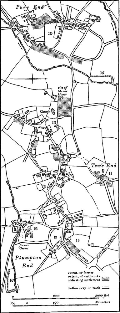
Fig. 91 Paulerspury (10–14) Settlement remains, (15, 16) Fishponds
a(8) Roman Settlement (?) (SP 722469), in the N.E. of the parish, on Upper Lias Clay at 92 m. above OD. Roman material is recorded in this area (Northants. Archaeol., 9 (1974), 95; CBA Group 9, Newsletter, 4 (1974), 27).
a(9) Roman Settlement (?) (SP 717477), in the N. of the parish, on Boulder Clay at 90 m. above OD. Roman occupation debris has been noted (Northants. Archaeol., 9 (1974), 95; CBA Group 9, Newsletter, 4 (1974), 27).
For Roman pottery and possible burials, see (24).
For Roman Road 1e, Watling Street, see Appendix.
Medieval and Later
(10–14) Settlement Remains (Figs. 91 and 92). The village of Paulerspury is dispersed over an area of 2 square kilometres and appears to consist of five separate centres joined by a network of roads many of which now survive only as hollow-ways. These are Pury End in the W., Tew's End in the N. and Plumpton End in the S.E., as well as two parts of Paulerspury itself each associated with a small triangular green. Each of these centres has evidence of former settlement and is described individually below.
The village is first mentioned in Domesday Book, listed as a single manor of three and three-fifths hides, with a recorded population of 33 including a priest (VCH Northants., I (1902), 339). This figure almost certainly includes the hamlet of Heathencote (18). In 1334 the village cum membris paid 118s. 6¼d. for the Lay Subsidy, one of the largest sums in the area (PRO, E179/155/3). In 1673, 130 people paid the Hearth Tax but this record again included Heathencote (PRO, E179/254/14). The total population of the parish in 1801 was 859. (RAF VAP CPE/UK/1926, 3236– 40, 5236–40; air photographs in NMR)
a(10) Settlement Remains (centred SP 710455; Figs. 91 and 92), lie in and around the hamlet of Pury End, on limestone and Boulder Clay, between 105 m. and 120 m. above OD. The surviving earthworks fall into six groups: (a) On the W. side of Careys Road (SP 70914542), a series of very slight depressions bounded on the W. by a shallow ditch, marks the sites of former houses. (b) On the E. side of Careys Road (SP 70964540) indeterminate earthworks are probably also the remains of houses. (c) On the S.E. side of Lower Street (SP 71104535–71204558) there are more low house-sites and platforms separated by a bank from the adjoining ridge-and-furrow. At the N. end of the area the ridges appear to extend almost up to the road and to have ridden over earlier house-sites now reduced to amorphous scarps and depressions. A few sherds of medieval pottery associated with very dark earth have been picked up from molehills in this area. (d) At the N.E. end of Lower Street (SP 71004566) is a group of terraces cut by a later track, together with an old pond and other more indeterminate earthworks. These remains are the site of a large farmstead which still existed in 1820 (NRO, map) and was also shown on the OS 1st ed. 1 in. map of 1834. (e) At the N. end of the village (SP 70984574–71054592) the line of Careys Road is continued N.E. as a pronounced hollow-way up to 3 m. deep. This hollow-way forks (at SP 71084585), one branch curving S.E. and then S. to meet the N. end of Lower Street. The other branch runs N.N.W. to the stream. Beyond the stream its line is continued as a terrace-way much damaged by ploughing. All these routes were shown as roads on maps of 1728 and 1820 (NRO). (f) At the S. end of the village (SP 70974520) the line of Lower Street continues as a poorly preserved terrace-way S.W. along the valley side, and Careys Road runs on as a deep hollow-way climbing the hillside to the S. Both are shown as roads in 1728 and 1820.
a(11) Settlement Remains (centred SP 729458; Fig. 91), lie around the existing buildings at Tew's End, on limestone at 115 m. above OD. The amorphous earthworks are sites of buildings some of which were still standing in 1820 (map in NRO). The main feature is a large hollowway up to 2.5 m. deep at its N.E. end, which runs from the E. side of Tew's End Lane to the N. end of Longcroft Lane. This was still a through road in 1820.
a(12) Settlement Remains (SP 723453; Fig. 91), lie around Plumpton End, on Boulder Clay at 108 m. above OD. From the evidence of maps of 1728 and 1820 (NRO) and air photographs (RAF VAP CPE/UK/1926, 3238–9, 523840) the hamlet originally lay around a small triangular green immediately E. of the existing N.-S. road and on the N. side of the stream. From the N.E. corner of the green a road ran N. to the E. end of Paulerspury. The green has now been partly built over but the road survives as a hollow-way 15 m. wide (SP 72424540). Other remains include the N. boundary of the settlement, now a low bank (SP 72404536), some amorphous earthworks probably the sites of buildings on the W. side of the modern road (SP 72344533), and a terrace-way on the S. side of the stream running S.E. from the green (SP 72454525). It is recorded that in a close 'named the Hall Close, stood the old Manor-house called Plumpton Hall-foundations of buildings are said to have been dug up here' (J. Bridges, Hist. of Northants., I (1791), 315).
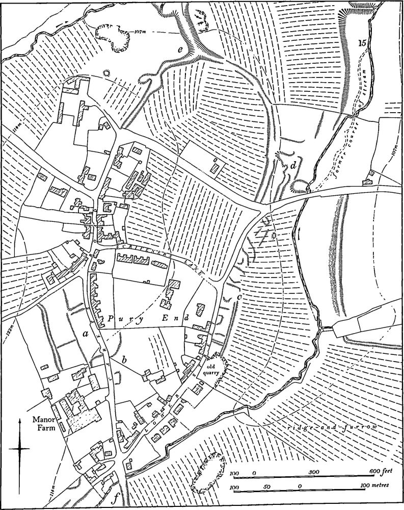
Fig. 92 Paulerspury (10) Settlement remains, (15) Fishpond
a(13) Settlement Remains (centred SP 716454; Fig. 91), lie in several places around the W. half of Paulerspury village, on Boulder Clay between 110 m. and 125 m. above OD. (a) Immediately N. and W. of the church (SP 71494553) is a large area of earthworks which include some old quarries and relatively recent hedge-banks. There is also a curving terrace-way on the hillside N. of the church and this continues along the line of the modern road to the N. There is at least one house-site to the W. of this terrace-way. Immediately W. of the church are stone and brick foundations of a recently demolished farm building. The latter apparently stood on the site of the original manor house of Paulerspury which was demolished at the end of the 18th century (J. Bridges, Hist. of Northants., I (1791), 311; G. Baker, Hist. of Northants., II (1836–41), 120). This manor house and the associated earthworks lay within a large rectangular area bounded on the N. by the Pury End Road, on the E. by Church Lane and on the W. by a double scarp or terrace-way which runs S. from Pury Lane (at SP 71334562) along the valley side and down to a small stream (SP 71304543). Beyond the stream the S. boundary of the site continues as a well-marked bank with ditches on each side, extending E. to a point just W. of the green (SP 71004538). These boundaries may have enclosed a formal garden belonging to the manor house. In 1972 a trial excavation was carried out across the terrace-way. Two deeply cut V-shaped ditches were discovered, the upper containing medieval pottery and the lower Roman (see (6); Northants. Archaeol., 8 (1973), 21). (b) On the S.E. side of Park Lane (SP 71634526) are very slight earthworks, now almost ploughed out, probably the sites of former houses. (c) On the N. side of Lumber Lane (SP 71764538) slight earthworks also probably represent buildings now demolished. (d) On the S. side of High Street (SP 71884548) air photographs (RAF VAP CPE/UK/1926, 3238–9) show traces of another house-site now destroyed by the recreation ground. (e) N. of High Street and parallel to it (SP 71584562–71864566) are the remains of a broad hollowway up to 1.5 m. deep which ran from the sharp bend in Tew's End Lane to the right-angle bend in Pury End Road N. of the church. This road had already been abandoned by 1728 (map in NRO). (f) The S. end of Park Lane (SP 71594521) formerly continued S.W. as a deep hollow-way running between ridge-and-furrow. This was still a road to Whittlebury in 1820 (map in NRO). Most of it has recently been destroyed by ploughing. (g) From the sharp bend in Lumber Lane (SP 71854531) a hollow-way continues S.E. for 100 m. Its N.W. end has been destroyed by modern housing.
a(14) Settlement Remains (centred SP 723455; Fig. 91), lie in several places in the E. half of Paulerspury village, on Boulder Clay between 115 m. and 120 m. above OD. (a) On the N.W. side of Grays Lane (SP 72524563) there were formerly at least two house-sites separated from the ridge-and-furrow on the N. by a well-marked ditch. These have now been destroyed by modern housing. Immediately to the S., on the opposite side of the road, 14th and 15th-century pottery has been found (Northants. Archaeol., 10 (1975), 169). (b) Fragments of a hollow-way now largely destroyed by houses and gardens can be traced running from the High Street (SP 72184547) in a broad curve to meet the road to Plumpton End (SP 72364543). This was a through road in 1728 but had been partly abandoned by 1820 (maps in NRO). (c) A small section of an irregular hollow-way exists E. of the Plumpton End Road (SP 72454547). In 1728 this was part of a loop road which ran in a curve from the Plumpton End Road to Plum Park Lane (map in NRO). A hollow-way from Plumpton End (12) runs into it. (d) At the extreme S.E. end of Plum Park Lane (SP 72624545) is a broad hollowway running S.E. through the adjacent ridge-and-furrow. This road is not shown on any map but it may have led to the fishpond (16).
a(15) Fishpond (SP 713458; Figs. 91 and 92), lies N.E. of Pury End in the bottom of the valley of a small N.-flowing stream, on clay at 100 m. above OD. A large roughly rectangular pond cut back into the valley side on the W. has a massive dam up to 3 m. high at the N. end. There is no trace of an artificial edge on the E. side; the steep natural slope seems to have sufficed. The original course of the stream is still visible in the bottom of the pond and to the S. The pond had probably been abandoned by 1728 for it is not depicted on the map of that date though the field to the N. was then known as The Fishweir. (RAF VAP CPE/UK/1926, 3237–8; air photographs in NMR)
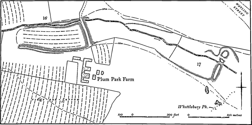
Fig. 93 Paulerspury (16, 17) Fishponds
a(16) Fishpond (SP 727452; Figs. 91 and 93), lies immediately N.W. of Plum Park Farm, on clay and alluvium at 99 m. above OD. A large dam 2.5 m. high spans the valley of a small E.-flowing stream. The limits of the former pond, of some 1.75 hectares, are marked on the S. side by a steep artificial scarp up to 2 m. high at the E. end but fading out at the W. end where it becomes a bank. The N. side is marked by a scarp 1.25 m. high, above which the stream now flows in a narrow artificial channel cut into the hillside. The bottom of the pond is ploughed in ridge-and-furrow which appears to be later than the construction of the dam although it is not clear whether the ridges were formed after the pond had been abandoned or whether the ploughing was part of a medieval rotation of fish and arable farming (RCHM Northants., II (1979), Braybrooke (1) and Dingley (3)). However the land immediately to the N. has no ridge-and-furrow on it, and none was visible in 1947 when the area was still permanent pasture. It appears, therefore, that there was no obvious shortage of arable land in the area in medieval times and it is likely that the ridge-and-furrow in this pond is indeed part of a rotational system. (RAF VAP CPE/UK/1926, 5239– 40)
a(17) Fishpond (SP 731451; Fig. 93, to the E.S.E. of and below (16), in a similar situation. The valley bottom is spanned by a dam 2.5 m. high with two later gaps in it through one of which the stream flows. At the N.E. end of the dam and cut back into the hillside is an original overflow channel. Upstream the edges of the pond are marked by low scarps. (RAF VAP CPE/UK/1926, 5239–40)
a(18) Settlement Remains (SP 710473; Figs. 16 and 94), formerly part of Heathencote, lie around the existing hamlet in the N. of the parish, on Boulder Clay at 115m. above OD. The settlement is first mentioned by name as Heymundecot in 1220 (PN Northants., 104) but is probably much older. It is presumably included silently under Paulerspury in Domesday Book and in all medieval taxation records is listed with Paulerspury except in 1525 when 11 people at Heathencote paid the Lay Subsidy (PRO, E179/ 155/130). By 1720 (J. Bridges, Hist. of Northants., I (1791), 314–5) it consisted of 'six farms and ten families in scattered houses'.
The hamlet is shown much as it is today on a map of 1820 except that a group of buildings is depicted to the W. on either side of a road running N. from Watling Street (SP 706474). The buildings have now been destroyed and all that remains is an area of ill-defined earthworks and part of a road surviving as a shallow hollow-way. Within the hamlet itself the probable sites of former houses survive in the S.E., and to the N.E. a broad hollow-way continues the line of the single street into the valley bottom where it is blocked by a small 18th-century cottage. Other fragmentary earthworks lie on each side of this hollow-way. Some 13th and 14th-century pottery has been found in the area (NM; BNFAS, 4 (1970) 21; Northants. Archaeol., 13 (1978), 187). The two separate areas of settlement existing in 1820 might indicate that Heathencote was once two places. (RAF VAP CPE/UK/1926, 1236–7)
a(19) Windmill Mound (SP 70874794), lies immediately E. of Park Hall, on glacial gravel at 105 m. above OD. A circular mound 20 m. in diam. and 1.8 m. high, surrounded by a ditch 0.4 m. deep, is probably the site of a medieval windmill (Med. Arch., 18 (1974), 216). The N. side and the interior have been damaged by digging, but there are traces of an original central depression. The surrounding ridge-and-furrow does not impinge on the mound.
b(20) Deer Park (centred SP 715445; Fig. 16), occupies just over 100 hectares of land in the S. of the parish, on Boulder Clay between 135 m. and 120 m. above OD. There is some confusion in the literature between the history of this park and Plum Park (21).
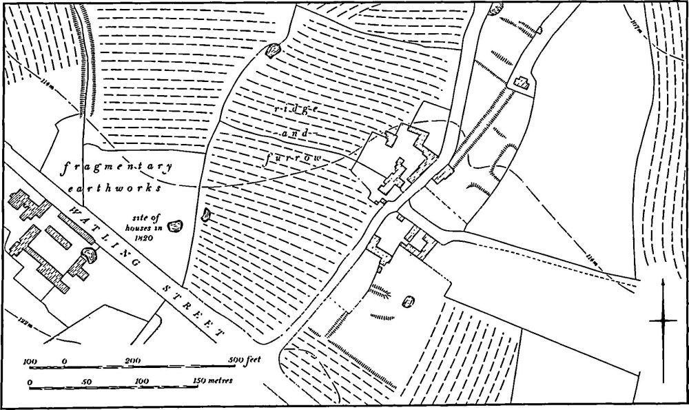
Fig. 94 Paulerspury (18) Settlement remains at Heathencote
A small park of only 17 acres was created in 1363 by John de Pavely (G. Baker, Hist. of Northants., II (1836–41), 204) and this seems to be the origin of the one described here. In 1410 John St. John had two parks 'called the Oldeparke and New Parke which the said John has a field called Farmsted and 100 acres of land and a wood adjoining the said field ... containing 100 acres of land'. St. John was licensed to enclose the two parks, the field and the wood and make a new deer park (Cal. Charter R., 1314– 1417, 442). This conversion of apparent arable land into a deer park is of interest, for much ridge-and-furrow is traceable within the park today (RAF VAP CPE/UK/1926, 5236–9). In 1541 the park was alienated to the Crown and it was disafforested in 1639 (P. A. Pettit, The Royal Forests of Northants. 1558–1674 (1968), 14, 90, 192).
The exact location of the two pre-1410 parks is unknown, but the boundaries of the later one are clear. From the S. end of Park Lane, to the S. of Paulerspury church (SP 716452), the boundary ran S.E. until it met the lane running S. from Plumpton End (SP 723448). No trace remains here as the hedge has been realigned, but the fact that Breach Field, one of the common fields of Paulerspury, still existed to the N.E. in 1820 (map in NRO) suggests that the park boundary lay approximately along this line. It then ran S. along the W. side of the Plumpton End lane to the Paulerspury-Whittlebury parish boundary (SP 724442). No indication of the park boundary can be seen along the lane. This boundary then turned W. and followed the parish boundary for 1.75 km. to just S.W. of Park Farm (SP 709445). Again there is little indication of a park boundary, except to the S.E. of Park Farm (SP 712442–715440) where the modern hedge lies on top of or just N. of a large bank up to 1.5 m. high and 10 m. wide, and further W. (at SP 710444) where, though no hedge remains, air photographs show traces of an almost ploughed-out bank, with a broad ditch on the N. side (i.e. inside the park). To the S.W. of Park Farm the park boundary met the hollow-way or lane running S. from Pury End and ran along its E. side (SP 709445–710452). In a few places along this lane are the remains of a large bank up to 1.25 m. high. At the S. corner of Pury End the deer park boundary seems to have followed the stream. It then must have turned S.E., along the S.E. side of Paulerspury village, to reach the S. end of Park Lane. No boundary bank has been observed here. (Northants. P. and P., 5 (1975), 229–30; Milton Keynes Journal, 3 (1974), 67–8; Med. Arch., 18 (1974), 218)
b(21) Deer Park (centred SP 733454; Fig. 60), known as Plum Park, lies in the S.E. of the parish, on the E. side of Watling Street, on Boulder Clay between 100 m. and 115 m. above OD. It covers only 30 hectares of land, and adjoins Grafton Park (Grafton Regis (8)) and Potterspury Park (Yardley Gobion (8)).
The park is first recorded in 1328 when it was created by Richard Damory. Its later history is not well documented, but it was still known as The Park in the early 19th century (Northants. P. and P., 5 (1975), 230; Milton Keynes Journal, 3 (1974), 68; G. Baker, Hist. of Northants., II (1836–41), 213).
The S.W. edge of the park lay along Watling Street, though no indication of any boundary survives along it today. The N. side of the park (SP 728457–734459) is marked by a scarp up to 1 m. high but a line of old quarries on the S. side has obscured any original ditch (RAF VAP CPE/UK/1926, 3240–1). The E. side coincides with the Grafton Regis parish boundary as well as with the boundary of Grafton Park. The N. part (SP 734458) of this side has been ploughed over but the original boundary, consisting of a ditch between two banks, is visible on air photographs. Within a small copse known as Grafton Park (SP 734456) a bank 1.25 m. high and 7 m. wide survives but thereafter nothing is traceable in the modern arable until the assumed boundary meets Watling Street (SP 735450). Ridge-and-furrow is visible over most of the interior of the park arranged in interlocked furlongs. It has been suggested (Milton Keynes Journal, op. cit.) that the park was laid out around existing common field furlongs.
a(22) Post-Medieval Pottery Kiln (SP 722467), lies N. of the village of Paulerspury, on Upper Lias Clay, at 91 m. above OD. Excavation has revealed an oval pottery kiln, 2.13 m. by 4.26 m., constructed of tile and clay. A range of forms and fabrics was produced (Northants. Archaeol., 9 (1974), 112; Milton Keynes Journal, 3 (1974), 28–30; Post-Med. Arch., 2 (1968), 55–82).
(23) Cultivation Remains. The common fields of Paulerspury, together with those of Heathencote, were enclosed by an Act of Parliament of 1819 (NRO; Enclosure Map, 1820; map of Heathencote, 1819; map of Paulerspury, 1728). A detailed description of the arrangement of these fields and their surviving ridge-and-furrow has already been published (Milton Keynes Journal, 3 (1974), 67–71). This work has shown that the position in 1819, when there were no less than 11 open fields of various sizes in the parish, was only the last stage in a process of development and change which is not clearly understood.
Large areas of ridge-and-furrow survive on the ground or can be traced on air photographs. It is still particularly well preserved in the N. of the parish within the area of Towcester Racecourse where end-on and rectangular furlongs exist. This area was part of Towcester Field in 1819 and was probably one of at least three open fields cultivated by the inhabitants of Heathencote (18). Other ridge-and-furrow can be traced within the extensive old enclosures around Paulerspury village (Figs. 91 and 92) and within both the medieval deer parks (20) and (21). (RAF VAP CPE/ UK/1926, 1236–41, 3236–44, 5236–41)
Undated
a(24) Burials (SP 714465), N. of Pury End and N. of the fishpond (15). Large quantities of human bones of both sexes, including children, have been found over a number of years in this area. A few sherds of Roman pottery, including the base of an unusual 1st-century pot, have also been discovered. It has been suggested that it is the site of a Saxon cemetery but this is by no means certain. (CBA Group 9. Newsletter, 4 (1974), 27; Northants. Archaeol., 13 (1978). 182)