An Inventory of the Historical Monuments in the County of Northamptonshire, Volume 4, Archaeological Sites in South-West Northamptonshire. Originally published by Her Majesty's Stationery Office, London, 1982.
This free content was digitised by double rekeying. All rights reserved.
'Thenford', in An Inventory of the Historical Monuments in the County of Northamptonshire, Volume 4, Archaeological Sites in South-West Northamptonshire, (London, 1982) pp. 143-145. British History Online https://www.british-history.ac.uk/rchme/northants/vol4/pp143-145 [accessed 25 April 2024]
In this section
58 THENFORD
(OS 1:10000 SP 54 SW)
The long, narrow parish covers only 364 hectares. It slopes generally S. across Upper and Middle Lias Clay and Marlstone Rock, from a maximum height of 180 m. where Northampton Sand outcrops, and is drained by small streams on the S.E. and S.W. boundaries at about 110 m. above OD. The parish is rich in archaeological remains which include an Iron Age earthwork (2), a large Roman villa (4) and a Saxon cemetery (9).
Prehistoric and Roman (Fig. 85)
The extensive and detailed fieldwork carried out in this part of the county by D. J. Barrett (see Marston St. Lawrence) has led to the identification of several sites and finds in Thenford parish. The finds unassociated with known settlements are here listed under their various categories: (a) four flint arrowheads of different types (SP 528413); (b) a fragment of a polished stone axe of Group VI (SP 52314277); (c) small scatters of worked flints of late Neolithic and Bronze Age type (SP 52424347, 52804310, 52264257, 52594251, 51634151, 52524078). A middle Bronze Age palstave is also recorded in the parish (BM; copy in NM; Arch. J., 110 (1953), 178). A late Bronze Age hoard found in the 19th century 'at Thenford Hill Farm' (about SP 525438) contained two swords, four spearheads, two rings and other bronze objects as well as a piece of wood (BM; Inventaria Archaeologia, 2nd set (1955), G.B. 12, 1–3). Its exact find spot is unknown, but it may have come from the vicinity of the Iron Age settlement (2).
(1) Prehistoric Settlement (centred SP 527416), to the E. of the village, on Marlstone Rock at 125 m. above OD. Worked and waste flints of late Neolithic and Bronze Age type occur over an area of some 3 hectares. Twelve flint arrowheads of various types and fragments of two stone axes, one of tuff and one of Group VI, have also been found. Part of another axe of Group VI, as well as some microliths have been found further to the E. (SP 524415). For Roman material from this area, see (4). (inf. D. J. Barrett)
(2) Iron Age Settlement (SP 523440; Fig. 110), lies in the extreme N. of the parish, on the W. slope of a rounded hill of Northampton Sand, between 168 m. and 175 m. above OD. The site, sometimes known as Arbury or Arberry Hill, has elsewhere been described as a hill fort, but it was probably no more than a lightly defended farmstead. It was once almost circular, 150 m. across, and bounded by a bank or rampart. The area has long been under cultivation with the result that much of the rampart has been almost completely ploughed out. On the N.E. only a broad scarp survives, up to 1.5 m. high and spread by ploughing. A low bank 0.5 m. high in the S.E. and another scarp less than 1 m. high on the S.W. are all that remains of the original bank in this area. The scarp extends N. and curves N.E. and this section, outside the modern arable land, is the only well-preserved part; even here a quarry has been cut into the bank. The bank is 20 m. wide and is 2.5 m. high from the outside but only 0.5 m. from the inside. A large area of late Neolithic or Bronze Age worked and waste flints has been found in the S.E. of the site. Further scatters of flints, including microliths, lie well outside the main enclosure to the E. and S.W. (SP 52344390, 52054385). A few sherds of Iron Age and Roman pottery are recorded from the E. part of the site and the late Bronze Age hoard (see above) discovered in the 19th century may also have come from here. (A. Beesley, Hist. of Banbury (1841), 31; Arch. J., 110 (1953), 178; RAF VAP CPE/UK/1926, 1211–2; CPE/UK/1994, 1024–5)
(3) Roman Settlement (?) and Burial (SP 519417), lies in Thenford churchyard, on Middle Lias clays and silts at about 115 m. above OD. Morton (Nat. Hist. of Northants. (1712), 529) records the discovery of an urn with ashes in it at this point and also states that 'tesserae were found in the field and a medal of Constans'. In the 19th century, Baker (Hist. of Northants., I (1822–30), 717) referred to fragments of Roman material 'traced in the village causeway'. These finds, apart from the burial, may relate to the villa (4).
(4) Iron Age and Roman Settllment and Roman Villa (SP 52524158), lie E. of the village, on Marlstone Rock at 130 m. above OD. Evidence of a large Roman building was first recorded in the early 19th century when foundations, a hypocaust, tesserae and coins from Tetricus to Constans were found (G. Baker, Hist. of Northants., I (1822–30), 717). A few years later there is a record of skeletons found in the garden of Thenford House (A. Beesley, Hist. of Banbury (1841), 32). Both these writers located the finds in the area S. of the walled garden of Thenford House (i.e. SP 524418).
Excavations between 1971 and 1973 revealed a villa with four main phases of occupation. The earliest phase was an Iron Age ditch which was overlaid by a large stone building, possibly an early villa or agricultural building. This structure later had a room and a corridor added to it. Around A.D. 300 the main villa was erected to the N. of the earlier building. It consisted of a range of six rooms one of which contained a fine mosaic. The villa was later extended to the S. to meet the earlier building and another room was added to the W. with a bath suite to the N. The whole building was later demolished and levelled to make a courtyard. The mosaic is preserved in Thenford House. (BNFAS, 7 (1972), 32; Northants. Archaeol., 8 (1973), 17; 9 (1974), 96; DOE Arch. Excavations 1972 (1973), 62; 1973 (1974), 55; CBA Group 9, Newsletter, 2 (1972), 10; 3 (1973), 17; Britannia, 3 (1972), 325, 360; 4 (1973), 294; 5 (1974), 434; BAR, 41 (i) (1977). 152, No. 147).
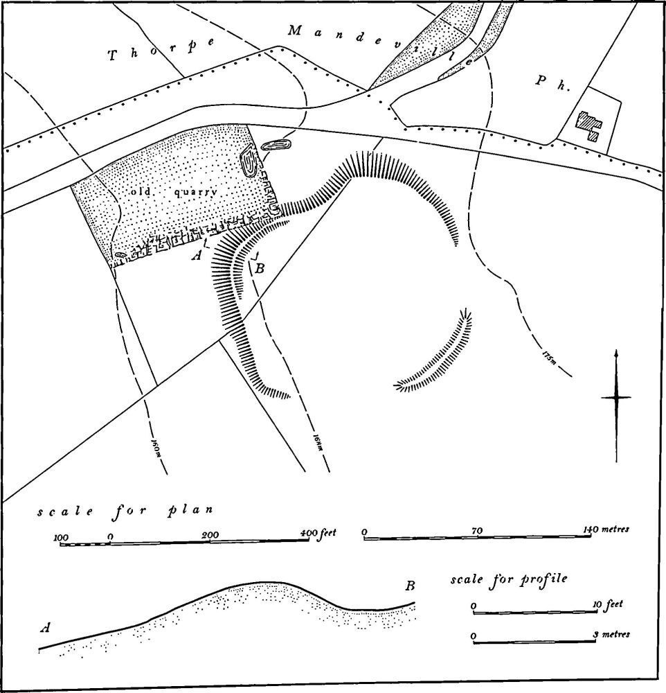
Fig. 110 Thenford (2) Iron Age Settlement
The villa lies on the W. edge of a large area of Roman occupation debris, some 10 hectares in extent, including a dense spread of pottery and tiles (centred SP 526416; inf. D. J. Barrett). For prehistoric material from this area, see (1).
(5) Roman Settlement (SP 517425), N. of the village, on the E. side of a small S.-flowing stream, on Upper Lias Clay at 130 m. above OD. Roman pottery and tiles are recorded from an area of some 3 hectares. A Roman coin and two flint arrowheads have also been found. (inf. D. J. Barrett)
(6) Roman Settlement (?) (SP 514422), 300 m. S.W. of (5), on the other side of the stream, on Upper Lias Clay at 125 m. above OD. A small scatter of Roman pottery and tiles, and some worked flints including Mesolithic blades and a single microlith are recorded. (inf. D. J. Barrett; CBA Research Report, 20 (1977), 217)
(7) Roman Settlement (?) (SP 526421), N.E. of the village, on Upper Lias Clay at 130 m. above OD. A small quantity of Roman pottery and tiles has been found here as well as some worked flints (inf. D. J. Barrett).
(8) Roman Settlement (?) (SP 524411), S.E. of the village, on limestone at 107 m. above OD. A few sherds of Roman pottery, fragments of tile and some worked flints have been noted (inf. D. J. Barrett).
Medieval and Later
(9) Saxon Cemetery (SP 514419), W. of the village, close to the parish boundary, on Upper Lias Clay at 122 m. above OD. Before 1830 at least seven skeletons arranged in three tiers were discovered in a large mound of earth and stones. The burials were thought to be secondary to the mound. There are references to 'many earthen urns, or drinking cups' but only one small black-ware vessel survives, accompanied by an iron knife (both in NM). Meaney gives a different location (SP 527435) but there seems no justification for this; the location given above fits the 19th-century description. Nothing now remains in the area but extensive shallow quarries. (G. Baker, Hist. of Northants., I (1822–30), 717; A. Beesley, Hist. of Banbury (1841), 31; VCH Northants., I (1902), 254; Meaney, Gazetteer, 196; OS Record Cards; J. N. L. Myres, A Corpus of Anglo-Saxon Pottery of the Pagan Period (1977), No. 811)
(10) Site of Manor House (SP 519416), lies immediately N.E. of the church, on Marlstone Rock at 120 m. above OD. The area is traditionally the site of the medieval manor house of Thenford which was described in the early 18th century as being partly built in the reign of Elizabeth I (J. Bridges, Hist. of Northants., I (1791), 203). It was probably pulled down soon after 1765 when the present Thenford House was built to the E. of the village (G. Baker, Hist. of Northants., I (1822–30), 714). The site is now a flat pasture field with no surface features except at the N. end where there are a few low scarps.
(11) Site of Watermill (SP 517419), lies W. of the village, in the valley of a small stream flowing S.E., on Middle Lias Clay at 122 m. above OD. The mill itself stood until a few years ago, but has now been demolished. Traces of its foundations, leats and the mill-pond to the N.W. still remain. The pond is called Mill Pond on the Tithe Map of 1851 (NRO).
(12) Windmill Mound (SP 517422), lies to the N. of the village, on the side of an open shallow valley, on Marlstone Rock at 130 m. above OD. The field was known as Windmill Ground in 1851 (NRO, Tithe Map). On air photographs taken in 1947 (RAF VAP CPE/UK/1926, 3210–2) what appears to be a circular mound some 20 m. in diam. is visible. It has since been totally destroyed.
(13) Cultivation Remains. The common fields of Thenford were enclosed by an Act of Parliament of 1766, but no details of them are known. Ridge-and-furrow of these fields exists on the ground or can be traced on air photographs over large parts of the parish. It is arranged mainly in end-on furlongs running generally E.-W. across the parish. This is at least in part the result of the adaptation of the ridges to the contours, although the long runs of end-on furlongs in the centre of the parish (around SP 525425) cannot be entirely attributed to this. Especially notable in this area are two adjacent furlongs with ridges of unusual width. No explanation can be proposed for these ridges almost 20 m. wide. (RAF VAP CPE/UK/1926, 1210–11, 3210– 3; CPE/UK/1994, 1024–6)