An Inventory of the Historical Monuments in the County of Northamptonshire, Volume 4, Archaeological Sites in South-West Northamptonshire. Originally published by Her Majesty's Stationery Office, London, 1982.
This free content was digitised by double rekeying. All rights reserved.
'Chipping Warden', in An Inventory of the Historical Monuments in the County of Northamptonshire, Volume 4, Archaeological Sites in South-West Northamptonshire, (London, 1982) pp. 27-32. British History Online https://www.british-history.ac.uk/rchme/northants/vol4/pp27-32 [accessed 11 April 2024]
In this section
13 CHIPPING WARDEN
(OS 1:10000 a SP 44 NE, b SP 54 NW, c SP 55 SW, d SP 45 SE)
The modern parish covers more than 950 hectares; the R. Cherwell forms its S. and E. boundaries, and the Oxfordshire boundary its S.W. side. From the river, here flowing at about 110 m. above OD, the ground rises across bands of Lower and Middle Lias Clay and Marlstone Rock to an area of Upper Lias Clay at 125 m. above OD. Northampton Sand outcrops in the E. on Warden Hill over 155 m. above OD.
There is evidence for both Iron Age and Roman occupation in the parish including the fortified site known as Arbury Banks (2) and the Roman villa (3). The modern parish includes the land of the deserted village of Trafford (10), formerly an extra-parochial part of Byfield parish. The medieval parish of Chipping Warden had a detached part to the N., now in Aston le Walls parish (Fig. 38) and a further detached area centred on the abandoned village of Stoneton, now in Warwickshire.
Prehistoric and Roman
The major portion of a large flint implement was found in 1961 in the N. of the parish (SP 517508: OS Record Cards; lost) and two bronze axes of unknown provenance have also been discovered (NM). A looped palstave and a socketed axe are said to have been found in 1977 N.W. of the village (SP 495497; Banbury Museum; Northants. Archaeol., 14 (1979), 102). Several Iron Age coins have been found in the parish; some are said to have come from the Iron Age site (2) or from the Roman villa (3) but these attributions seem uncertain. The coins include a British 'Remic' gold stater (Mack, 59) said to be from (2), a bronze coin of Tasciovanus, three bronze coins of Cunobelinus and an inadequately recorded gold quarter stater (S. S. Frere (ed.), Problems of the Iron Age in Southern Britain (1958), 223, 233, 284; OS Record Cards).
b(1) Ditched Trackway (?) (SP 509498), in the centre of the parish, N.E. of the village, on Upper Lias Clay at 137 m. above OD. Air photographs (NCAU) show two parallel ditches 12 m. apart orientated N.-S. and visible for 90 m. It is not clear whether the feature is overlaid by ridge-and-furrow; it may be recent.
a(2) Iron Age Fort (SP 494486; Fig. 36), known as Arbury Camp, lies on the flat summit of a low rounded hill S.W. of Chipping Warden village, mainly on Marlstone Rock at 134 m. above OD. The monument is of considerable interest not only as a rare survival of an upstanding prehistoric site in this part of the county but also because of the medieval land use; the ramparts have been incorporated into the headlands of the common field system of the parish (11) and a windmill (7) stood on a mound on part of the outer bank. The E. part and the S.W. corner are now arable land, but the rest is permanent grassland.
The site was described by Bridges in the early 18th century (Hist. of Northants., 1 (1791), 111) who said: 'It is certain that no Roman coins or other marks of antiquity have ever been discovered there, though the ground is now ploughed up'. The absence of finds from the site is still notable, though one gold Iron Age coin, a British 'Remic' stater (Mack. 59; in private hands) is said to have come from the site. Five other Iron Age coins are recorded from the parish but were perhaps found on the Roman site (3) and not here (S. S. Frere (ed.), op. cit.). The site was described in the 19th century by A. Beesley (Hist. of Banbury (1841), 30); he interpreted it as circular with a large outer enclosure attached to it on the W. This idea was elaborated by the Ordnance Survey (OS Record Cards, 1968) who said that the site consisted of a hexagonal enclosure, probably Belgic in date because of its shape, a rectangular annex or extension to the W., a further annex to the N., and a bank of unknown purpose further W. again. These interpretations can be discounted as all the banks of the suggested annexes are simply well-marked headlands between ridge-and-furrow and have no connection with the fort itself. Moreover the fort is now hexagonal in plan almost certainly because its original ramparts have also been used as headlands of the medieval fields and have been pulled out of shape by ploughing. There is no reason to doubt that, in its original form, the enclosure was roughly circular.
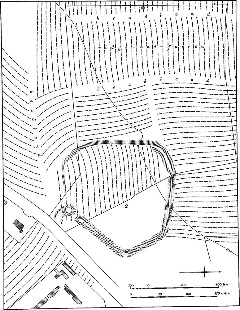
Fig. 36 Chipping Warden (2) Iron Age fort, (7) Windmill mound
The main enclosure covers just under 3 hectares and was presumably once bounded by a massive bank and external ditch, perhaps with an original entrance in the S.E. corner. The whole of the E. part is now under permanent arable and the surviving rampart is no more than 10 cm. high with no trace of a ditch. Air photographs (CUAP AKSIO; RAF VAP 106G/UK/721, 3002–4; in NMR) show three alignments of the rampart here, two of which, on the N. and E., have been straightened by being used as headlands in medieval times. All trace of the ridge-and-furrow has now disappeared except on the N. side. A short section of the rampart in the N.W. has been less damaged as the ridge-and-furrow to the N. stopped short of it and to the S. ran E.-W. below it. Here the rampart is 1.5 m. high above the land to the N. and 1 m. high above the interior. There is no ditch, any trace presumably having been destroyed by the adjacent ridge-and-furrow. The W., side is now reduced to a broad slightly curving scarp 2.5 m. high. The assumed outer ditch does not survive, again obliterated by the adjacent ridge-and-furrow, here running N.-S. The scarp itself has been used as a headland during the ploughing of the interior of the fort and its top is extremely uneven where the ridge-and-furrow rides over it.
The S.W. corner of the fort is now only a simple scarp 1 m.–1.5 m., curving first S.E. and then E. before fading out. The mound to the S. of it shown on OS 1:2500 maps is part of another medieval headland (as shown on plan). The S. side of the fort now hardly exists, for the W. part has been ploughed down into ridge-and-furrow which in turn has had a windmill mound (7) built over it. Immediately to the E. of the windmill mound is a small gap which may be an original entrance, for beyond it to the N.E. is the end of an original bank, 0.5 m. high. The W. half of the interior of the fort is covered by well-marked ridge-and-furrow running approximately E.-W., up to 0.5 m. high, and obscuring any original feature.
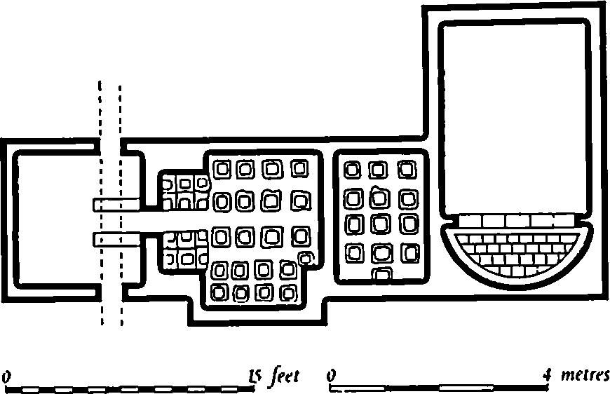
Fig. 37 Chipping Warden (3) Roman bath house (from a plan in VCH, Northants. I)
b(3) Roman Villa (SP 510482; Fig. 37), lies S.E. of the village, on a valley side close to the R. Cherwell, on Lias Clay at about 110 m. above OD. The site was known in the early 18th century, for Morton (Hist. of Northants. (1712), 526) records the ploughing up of foundation stones, ashes and Roman coins, but the main finds were made in the early 19th century. The ploughing of a field called Black Grounds revealed dark earth, foundations, dressed stone and Roman coins; in 1826 an urn containing human bones was discovered. Drainage work close to the river in 1849 produced much pottery, including samian, as well as four skeletons without grave goods apart from a small finger ring. This work also led to the discovery of a detached bath house near the river, consisting of three rooms and a stoke hole (Fig. 37). Subsequent ploughing across the whole area revealed extensive stone foundations and large quantities of Roman pottery from the 1st to the 4th century including much samian, coins and other small objects. Some of the Iron Age coins listed above may have come from this site. A small well is also recorded (G. Baker, Hist. of Northants., I (1822–30), 530–2; A. Beesley, Hist. of Banbury (1841), 27; JBAA, 5 (1850), 83, 168; VCH Northants., I (1902), 200; OS Record Cards).
For Anglo-Saxon finds from this site, see below.
Medieval and Later
Anglo-Saxon objects found in the parish include sceattas said to have come from the site of the Roman villa (3) (JBAA, 2 (1847), 346; VCH Northants., I (1902), 255; Brit. Num. J., 47 (1977), 38) and a 6th-century francisca of unknown provenance, probably from a male grave (J. Northants. Mus. and Art Gall., 6 (1969), 47). An iron bolt-head with hinged barbs discovered on Warden Hill in 1836 has been interpreted as a relic of the Battle of Danesmoor (1469) (OS Record Cards; see (4)).
a(4) Cemetery (around SP 499485), S. of the church. In the early 19th century many burials were discovered, including large pits full of bones with a quantity of spurs, and single interments apparently laid out in lines. These remains have been associated with the Battle of Danesmoor (1469) which took place in the neighbouring parish of Edgcote (JBAA, 1 (1845), 56; OS Record Cards; A. Beesley, Hist. of Banbury (1841), 28).
b(5) Moat (SP 501483), lay on the S.E. side of the village, close to the R. Cherwell, on Lower Lias Clay at 105 m. above OD. The moat has been almost completely destroyed by ploughing and the ground returned to pasture. From plans made before destruction, the site appears to have been a simple moated enclosure of roughly rectangular form (OS 1:2500 plan, Northants. LIV 7; G. Baker, Hist. of Northants., I (1822–30), 527). Air photographs (RAF VAP 106G/UK/721, 3002–3; CPE/UK/1926, 1069–70, and in NMR) show slight traces of what appears to be ridge-and-furrow on the island. Water entered the moat near its N.E. corner and returned to the R. Cherwell by a large ditch on the S.E. side. In 1809 (NRO, map of Chipping Warden) the area was known as Castle Yard but nothing is known of its history.
d(6) Fishponds (SP 501486), lie 200 m. N.W. of (5) and immediately S.E. of the village, in a shallow valley at the N. end of Edgcote Park, on Middle Lias Clay at 122 m. above OD. They consist of a line of three flat-bottomed ponds, each cut down 2 m. into the valley floor. The two upper northernmost ponds are small and have been much altered by later activity but the lower one is larger, 120 m. by 50 m. All have earthen dams up to 1.5 m. high. The ponds were filled by springs above the upper pond and water still runs from the lower pond down the valley towards the moated site (5) which it once filled. Immediately to the W. of the lower pond there are other earth works including large scarps up to 2.5 m. high. These have no coherent plan but may be the sites of houses removed when the park was made, perhaps in the 18th century (G. Baker, Hist. of Northants., I (1822–30), 527; air photographs in NMR).
a(7) Windmill Mound (SP 49434847; Fig. 36), lies on the edge of a low rounded hill S.W. of the village, on Marlstone Rock at 134 m. above OD. The mound lies on top of the S. rampart of the Iron Age fort known as Arbury Banks (2). It is roughly circular, 20 m. in diam. and 2.25 m. high, with a flat top 9 m. across, and has a slight cross-shaped depression in the centre. There are traces of a ramp leading on to the mound from the S.E. The mill was constructed on the S. rampart of the fort, which had already been diminished by ploughing. The plough ridges can be seen to underlie the mound. Two ridges approach the mound from the W. The northernmost passes under the mound but was later reploughed short of it and thus has a secondary headland on the edge of the mound. The southernmost ridge also passes under the mound, but has not been reploughed. In the 19th century (NRO, Tithe Map, 1837) the field in which the mound lay was known as Windmill Bank, but no mill then existed. (CUAP, AKSIO; RAF VAP CPE/UK/1926, 1070–1)
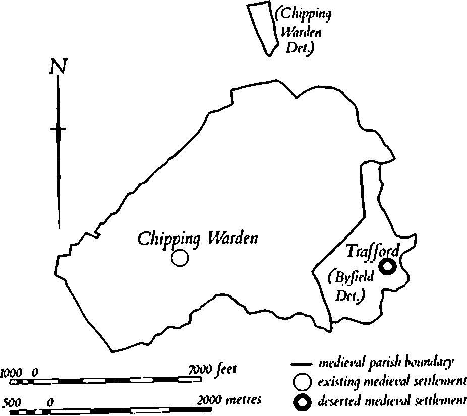
Fig. 38 Chipping Warden Medieval settlements and estates
a(8) Fishpond (SP 497484), lies 225 m. S.W. of the church, in the bottom of a small S.-draining valley, on Middle Lias Clay at 120 m. above OD. It is roughly rectangular, 40 m. by 65 m., cut back into the adjacent hillside to a depth of 2 m., with a massive earthen dam 15 m. wide and 2.5 m. high at the S. end. Nothing is known of its date or history. (RAF VAP 106G/UK/721, 3002–4; air photographs in NMR)
a(9) Settlement Remains (SP 497486), formerly part of Chipping Warden village, lay W. of the church in the angle between the Banbury Road and Mill Lane. Air photographs taken in 1947, before the area was built over, show a series of rectangular closes or paddocks bounded by low scarps. More closes to the S. (at SP 497484) had already been partly destroyed when the air photographs were taken. No definite building sites are visible and the earthworks may have been small fields. (RAF VAP CPE/UK/1926, 1069–70)
b(10) Deserted Village of Trafford (SP 527486; Figs. 38 and 39), lies in the E. of the parish, on the W. side of the R. Cherwell, on Marlstone Rock and Lias Clay at 112 m. above OD. The village lay at the S. end of a long narrow strip of land bounded by the R. Cherwell, which was a detached part of Byfield parish until the late 19th century (NRO, Tithe Map of Byfield, (1837)).
The village is first mentioned in Domesday Book when it was listed as a small manor with a recorded population of six (VCH Northants., I (1902), 332). In 1301 13 taxpayers paid the Lay Subsidy (PRO, E179/155/31) but this is the last record of its population. Trafford is mentioned by name in the Nomina Villarum of 1316 but thereafter it was always taxed with Byfield. By 1547 600 sheep were kept on the manor which suggests that it was already depopulated. By the early 19th century only the present farmhouse and the existing cottages to the N. remained, though at least part of the E.-W. hollow-way appears still to have been used as a track (OS 1st ed. 1 in. map, 1834; K. J. Allison, et al., The Deserted Villages of Northants. (1966), 47).
The remains of the village are in poor condition but certain features are clear. A very damaged hollow-way up to 1 m. deep runs from the W. end of the site to immediately S. of Trafford Farm where it turns sharply S. and runs down the hillside to the R. Cherwell ('a'-'b' on plan). To the W. of the farm this hollow-way widens into a roughly triangular depression from the N. end of which another hollow-way extends N. and becomes a headland between rather narrow ridge-and-furrow. On the S. side of the main hollow-way lie the very degraded remains of a series of closes, with long boundaries surviving as scarps. At their N. ends, adjacent to the hollow-way, are several rounded or irregular platforms, possibly the sites of former buildings. A third, narrower hollow-way runs N.E. and then N.W. from the point where the first meets the river. Below it to the E., in the bend of the river, are two rectangular fishponds, set at right angles to each other and up to 1.5 m. deep ('c' on plan). Immediately N. of the farm are traces of at least one enclosure bounded by low scarps. To the S.W. of the village remains there was formerly a large rectangular pond, but this has recently been altered and extended to the E. and filled with water. (RAF VAP CPE/UK/1926, 1065–6)
(11) Cultivation Remains. The common fields of Chipping Warden were enclosed by an Act of Parliament of 1733, but no details of the fields are known. Ridge-and-furrow exists on the ground or can be traced on air photographs over much of the land attributable to Chipping Warden village, arranged in end-on or interlocked furlongs. In a few places, for example in and around Arbury Camp (2) to the W. of the village, the ridge-and-furrow is preserved in permanent pasture and is of a considerable height, up to almost 0.75 m. high in places. The headlands in the area of Arbury Camp are especially notable, not only for their size but also because they have in the past been interpreted as part of the Iron Age camp (Fig. 36).

Fig. 39 Chipping Warden (10) Deserted village of Trafford
Elsewhere headlands survive as broad ridges in permanent arable land (e.g. SP 504495). Ridge-and-furrow is traceable on the higher broken land in the N.E. of the parish around Warden Hill, indicating that almost the whole parish has been under cultivation at some time. There is one exception to this E. of Warden Hill Farm (SP 519497) where, though there is ridge-and-furrow in the bottom and along the N. side of a steep-sided valley, the S. side shows no evidence of ploughing. This is due to the fact that the unstable clay has formed landslips which have not been ploughed. Further N. (SP 517499) there is a large area of narrow-rig ploughing, presumably of late 18th or 19th-century date.
Although the exact date is not known, the enclosure of the common fields of the now deserted village of Trafford (10) had presumably taken place by 1547 when sheep were being grazed there in some numbers. Ridge-and-furrow of these fields exists on the ground or can be traced on air photographs over the whole of the small area of land attributable to Trafford (Fig. 38). Except for the high land to the N.W. of the village itself (SP 523488) where the furlongs are interlocked, all the ridge-and-furrow is orientated E.-W., extending down the W. side of the Cherwell valley. (RAF VAP CPE/UK/1926, 1064–71, 3065–8; CPE/UK/ 1994, 2101–7, 4102–5; 106G/UK/721, 3301–4)
Undated
a(12) Bank (SP 49924910), known as Wallow Bank, lies on the N.W. edge of the village immediately N.E. of Manor Farm, on the N. side of the Byfield Road. It is on flat ground, on Marlstone Rock, at 132 m. above OD.
Probably because of the existence of Arbury Camp (2) to the S.W. and of the large Roman settlement to the E. (3), as well as the name Aston le Walls to the N., the bank has been interpreted in a number of ways, all unsubstantiated. It was first mentioned by Morton in the early 18th century (Hist. of Northants. (1712), 525) and Bridges (Hist. of Northants., I (1791), 111) writing in about 1720 described it as an earthen rampart '24 paces in length (with) a narrow ridge; the west side of it is almost perpendicularly steep, the east is gradually sloped; from the foot to the ridge is 9 paces'. It was apparently dug into in 1824 when it was found to be of simple earth construction and in 1841 it was recorded as being about 28 m. long and about 2 m. high (A. Beesley, Hist. of Banbury (1841), 29). A skeleton was found within the bank in 1883 (Dryden Collection, Central Library, Northampton). The earthwork now consists of a broad bank, orientated N.N.W.-S.S.E., 32 m. long and 13 m. wide, much spread by gardening. Its N. end is rounded, and its S. end has been cut short and damaged by walls and hedges. No date or function can be assigned to the remains.