An Inventory of the Historical Monuments in the County of Northamptonshire, Volume 4, Archaeological Sites in South-West Northamptonshire. Originally published by Her Majesty's Stationery Office, London, 1982.
This free content was digitised by double rekeying. All rights reserved.
'Greens Norton', in An Inventory of the Historical Monuments in the County of Northamptonshire, Volume 4, Archaeological Sites in South-West Northamptonshire, (London, 1982) pp. 70-73. British History Online https://www.british-history.ac.uk/rchme/northants/vol4/pp70-73 [accessed 24 April 2024]
In this section
28 GREENS NORTON
(OS 1:10000 a SP 65 SE, b SP 64 NE, c SP 65 SW, d SP 64 NW)
The parish, some 980 hectares in area, is bounded on the S. by the R. Tove, on the S.W. and S.E. by S.-flowing tributary streams and on the N.E. by Watling Street (A5). From the alluvium and Upper Lias Clay of the valleys, at about 90 m. above OD, the land rises gently across outcrops of Northampton Sand and Oolitic limestones; outcrops of these formations occur mainly around the village and to the N.E. Patches of Boulder Clay cover the higher land rising to a maximum of 145 m. above OD on the W. boundary.
Very little prehistoric or Roman material has been found in the parish. The main monuments are the remains of the intricate medieval settlement pattern (Fig. 41).
Prehistoric and Roman
A polished flint axe was found in the village in the 1950s (SP 66924973; OS Record Cards).
a(1) Flint-Working Site (?) (SP 652508), in the N.W. of the parish, S. of the deserted village of Caswell (5), on Upper Lias Clay at 115 m. above OD. Worked flints including at least one barbed-and-tanged arrowhead have been found over a number of years (Northants. Archaeol., 9 (1974), 84).
a(2) Ring Ditch (?) (SP 678515), in the N.E. of the parish, immediately W. of Watling Street, on Great Oolite Limestone at 122 m. above OD. Air photographs (NCAU) show a probable ring ditch 20 m. in diam. with traces of other ill-defined features immediately to the N.
b(3) Roman Settlement (SP 675494), to the S.E. of the village, on Northampton Sand and Upper Lias Clay at 100 m. above OD. An extensive scatter of Roman pottery has been discovered (NM). It is known that the site has produced other material now in private hands (Northants. Archaeol., 13 (1978), 181).
For Roman Road 1f, Watling Street, see Appendix.
Medieval and Later
A wooden spear with a barbed iron head, probably post-medieval, has been found in the bank of a mill stream in the S. of the parish (SP 67384912; Northants. Archaeol., 10 (1975), 172).
In early post-medieval times there was a deer park in the parish, associated with the manor house. It is not recorded until 1546 (PN Northants., 43) and had been abandoned by the early 18th century (J. Bridges, Hist. of Northants., I (1791), 238). Its exact area is known from the 1726 and 1767 maps of the parish (NRO) which show it as a roughly rectangular area immediately N.W. of the village, between the Bradden and Blakesley roads (centred SP 664504). By the 18th century it was already divided into fields, all with park names. No identifiable boundaries survive apart from the normal hedge-bank around it.
(4)–(7) Settlement Remains (Fig. 41). The parish of Greens Norton, like Cold Higham, Blakesley and Pattishall parishes to the N. and W., had in medieval times a number of discrete settlements in addition to the main village (4): Caswell (5), Field Burcote (6) and Duncote (7). The remains, described below, add little to the documented history of these settlements; their origins and relationship to Greens Norton itself remain obscure. Part of the N. end of the parish apparently once belonged to the hamlet of Potcote in Cold Higham parish.
b(4) Settlement Remains (SP 668499, 669491 and 671492; Fig. 15), formerly part of Greens Norton, lie in and around the village on limestone, sand and clay between 100 m. and 120 m. above OD. Greens Norton has undergone many changes in the last two centuries and especially in recent years with the addition of large housing estates. The earliest depiction of the village, in the 18th century, (NRO, maps of 1726 and 1767) shows that it was then made up of two parts. In the N. was the main village, lying along the present High Street, with a large rectangular open space or green at the N. end already partly encroached upon; the church stood on the E. side of the green. To the S., linked to the main village by a narrow road and centred on the present hall, was a series of lanes with buildings scattered along them. These lanes are shown as already incomplete in 1726 and large parts of them have since been abandoned. The field evidence indicates that the street system here was once even more complex than is shown on the 18th-century maps. In the 18th century a lane ran S. in a double curve from the small triangular green at Bengal Manor to the R. Tove. This is now traceable as a hollow-way 1.5 m. deep for most of its length. Another hollow-way, also 1.5 m. deep, runs E. from this (from SP 66824913), following a sinuous course until it reaches the stream flowing S. from the main part of the village (SP 67084909). It then turns N.E. and runs straight between blocks of ridge-and-furrow to meet the modern Towcester road just N. of Mill Farm (SP 67354922). Only the E. end of this hollow-way, near Mill Farm, is shown as a road in 1726 and 1767. Near its W. end (SP 66904912) this hollow-way passes through an area of very disturbed ground covering about 0.25 hectares. This is the site of two houses which are shown on the 1726 and 1767 maps but which had gone by 1798 (NRO, Enclosure Map). In the 18th century another road ran N. along the stream from the point where the hollow-way crosses it (SP 67084904) as far as the bend in Bengal Lane, W. of the hall (SP 67014924). This also partly survives as a hollow-way. At its junction with Bengal Lane, and immediately S.W. of it, is another area of disturbed ground which is the site of a house which stood there until after 1798. To the N.E. another track, still just traceable, ran N.E. past the hall and then opened out into a small rectangular area where at least two cottages and a farm stood in the 18th century. These were all cleared away in the 19th century when the hall grounds were extended, but uneven ground in a copse N. of the hall (SP 67104933) marks the site of the cottages. From this point the track turned S.E. and ran to meet the hollow-way to Mill Farm (SP 67244917). A single house stood on the S.W. side of the track in the 18th century and its site is also marked by disturbed ground (SP 672492).
Nothing now remains of the open green at the N. end of the village. It was destroyed in the 19th century when the grounds of Falcon Manor were extended across the E. part, the present New Road was cut across it and the rest was built over. (RAF VAP F21 58/RAF/2316, 0065–7; air photographs in NMR)
a(5) Deserted Hamlet of Caswell (SP 651510), lay on the N. side of a small W.-flowing brook N.W. of Greens Norton, on Northampton Sand and Upper Lias Clay at 122 m. above OD. The settlement is not recorded in documents until 1200 (PN Northants., 43) but is presumably much older and is perhaps listed silently in Domesday Book under the large royal manor of Greens Norton (VCH Northants., I (1902), 304). In 1301 12 taxpayers are listed in the Lay Subsidy for Caswell (PRO, E179/155/31), and in 1316 the settlement is noted separately in the Nomina Villarum. Thereafter there is no record of its size until 1509 when the five houses which apparently constituted the whole hamlet were destroyed and the area enclosed and converted to pasture. This was carried out by Sir Nicholas Vaux who had inherited the manor of Greens Norton (K. J. Allison et al., The Deserted Villages of Northants. (1966), 36). By the early 18th century only two houses, one presumably the present farm, stood on the site (J. Bridges, Hist. of Northants., I (1791), 238). Traditionally this house is said to have been moated (G. Baker, Hist. of Northants., II (1836–41), 69). The earliest map of the area, dated 1726 (NRO), shows two farms, one called Pinkard's House and the other Grubb's House. The same two houses are shown on a later map of 1767 (NRO).
No earthworks survive at Caswell as a large factory has been built over much of the area. Even in 1947 there were no clearly defined remains in the area (RAF VAP CPE/UK/ 1926, 1042–3) and the only possible remnant of the settlement is the pond in the valley to the S. of the farm. This is a large triangular pond 1.5 hectares in extent, bounded on the W. by a dam up to 2 m. high. It is possibly the remains of a medieval fishpond, but it has been considerably altered in the post-medieval period.
a(6) Deserted Hamlet of Field Burcote (SP 667508), lies in the N. of the parish on the S. side of a small S.-flowing stream, on Northampton Sand and Upper Lias Clay at 120 m. above OD. The settlement is not recorded in documents until 1200 (PN Northants., 42) though it is presumably much older and is perhaps listed silently in Domesday Book under the large royal manor of Greens Norton (VCH Northants., I (1902), 304). In 1301 nine taxpayers are listed in the Lay Subsidy for Field Burcote (PRO, E179/155/31) and in 1316 Field Burcote is noted separately in the Nomina Villarum. Thereafter nothing is known of its size until 1499 when Sir Thomas Green destroyed four houses and enclosed the surrounding area and converted it to pasture (K. J. Allison et al., The Deserted Villages of Northants. (1966), 40). The place was termed a hamlet in the early 18th century (J. Bridges, Hist. of Northants., I (1791), 238) though on a map of 1726 (NRO) only two farms are shown there. In the late 19th century these two farm-houses still existed (Whellan, Dir., 519); today Field Burcote consists of a single farm.
No earthworks of the settlement itself now remain but the limits of the surrounding ridge-and-furrow suggest its original extent. Most of the area is occupied by farm buildings and yards, but a set of uneven hollow-ways cut into a small re-entrant valley immediately N. of the present farm and now ploughed out may be the remains of a road into the settlement. A quantity of medieval pottery, mainly of the 13th century, is said to have been found to the W. of the farm but this report cannot be confirmed (local inf.). (RAF VAP CPE/UK/1926, 1041–2; air photographs in NMR)
a(7) Settlement Remains (SP 672508), formerly part of the hamlet of Duncote, lie on the N. side of the existing houses, on Upper Lias Clay at 104 m. above OD. The settlement is not recorded until 1227 (PN Northants., 43) but like Caswell and Field Burcote it must be much older. In 1301 eight taxpayers are listed in the Lay Subsidy for Duncote (PRO, E179/155/31) but thereafter nothing is known of its size until the late 19th century. In the early 18th century it was described as a hamlet (J. Bridges, Hist. of Northants., I (1791), 238). In 1874 it was said to contain 18 houses (Whellan, Dir., 519); it is now smaller.
The only earthworks associated with Duncote are some slight traces of abandoned ditched closes behind the farm at the N.W. end of Duncote (SP 67255084) and a group of small rectangular closes bounded by low scarps to the N.W. of the houses on the S.E. side of the settlement (SP 67385079). (RAF VAP CPE/UK/1926, 1040–1; air photographs in NMR)
a(8) Garden Remains (SP 669502; Figs. 15 and 66), lie around the present Greens Norton Rectory, in an isolated position N. of the village, on Northampton Sand and Boulder Clay at 112 m. above OD. The main medieval manor house of Greens Norton which was already 'totally destroyed' by the early 18th century (J. Bridges, Hist. of Northants., I (1791), 238) is said to have stood to the N.W. of the church (G. Baker, Hist. of Northants., II (1836–41), 62). The earthworks appear to include the remains of a late 16th or early 17th-century garden associated with this manor house. The garden may relate to the period between 1552 and 1571 when the manor of Greens Norton was held by Sir William Parr (1513–71), later Marquess of Northampton. Maps of 1726 and 1767 and the Enclosure Map of 1798 (NRO) show only one building in the area, presumably the present rectory.
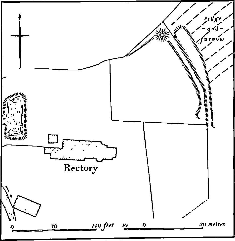
Fig. 66 Greens Norton (8) Garden remains
The main surviving feature is a tall conical steep-sided mound, 8 m. in diam. and 5 m. high with a small flat summit only 1 m. across. This stands in the N.E. corner of the present garden and is perhaps a prospect mound. A flat terrace or walk-way 3 m. wide and only 0.25 m. high extends S. from it along the edge of the garden, and a similar one runs W. but has been much damaged by the existing hedge. Outside the garden to the E. a large ditch 3 m. to 7 m. wide and up to 1.5 m. deep which has cut through the adjacent ridge-and-furrow was perhaps the source of material for the adjacent terrace and mound. (RAF VAP F21 58/RAF/2316, 0065–6)
a(9) Ponds (SP 667500 and 669501; partly on Fig. 66), lie to the E. and S.W. of the rectory, in the valley of two small S.W.-flowing streams, on clay, between 110 m. and 120 m. above OD. In 1767 (map in NRO) there was only a single circular pond immediately S. of the rectory. But by 1798 (Enclosure Map, NRO) a system of ponds had been constructed. To the E. of the rectory a large rectangular pond had been made; it contained two parallel low banks or islands running lengthways. This still remains, 80 m. by 40 m. and orientated N.E.-S.W., cut down at least 2 m. into the valley sides. The earlier circular pond to the S.W. of the rectory had, by 1798, been altered to form a U-shaped pond and below it to the S.W. has a long narrow pond containing two banks or islands end-on to each other down the centre. The U-shaped pond has now disappeared but the long pond remains as two separate ones, with a dam 2 m. high at the S.W. end of the lower one. No purpose can be assigned to these ponds. (RAF VAP F21 58/RAF/2316, 0065–6; air photographs in NMR)
(10) Cultivation Remains. The common fields of Greens Norton village were enclosed by an Act of Parliament of 1799. Immediately before that date (NRO, Draft Enclosure Map, 1798) there were four open fields around the village. To the W. of the village and immediately S. of the Bradden Road was Upper or Blackridge Field. To the S. of that, extending as far as the R. Tove, was Kingthorne Field. To the N.E. of the village was Church Field, with Lower Field to the S.E. However, an earlier map of 1767 (NRO) shows only three fields. Blackridge and Kingthorne Side Fields were identical to the two similarly named in 1798, but the later Church and Lower Fields were all one, then called Church Field.
Ridge-and-furrow of these fields survives on the ground or can be traced on air photographs over large areas, arranged in end-on and interlocked furlongs which agree exactly with the furlongs marked and named on the Draft Enclosure Map. Where the ridge-and-furrow no longer survives former headlands between furlongs are still visible as long ridges up to 10 m. wide and 0.25 m. high (e.g. SP 673495).
The common fields of Duncote were enclosed by the same Act of Parliament as that for Greens Norton. Before enclosure there were four open fields. East Field lay to the E. of the hamlet and North Field to the N. The area S. and S.E. of Duncote was the Mixt Field and there was a very small Church Field to the W. of the hamlet. As with Greens Norton, the earlier map of 1767 shows only three fields. The East and North Fields already existed but the later Mixt and Church Fields were a single unit called Church Field. Both the 1767 and 1798 maps show a large piece of land called Cow Common N. of Duncote, along the sides of a small S.-flowing stream. Ridge-and-furrow of these fields survives on the ground or can be traced on air photographs over large areas of all the former open fields, arranged in interlocked and end-on furlongs mainly lying at right angles to the contours. Some furlongs are preserved in permanent pasture (e.g. SP 677511). Ridge-and-furrow also exists N. of Duncote in the area of the former Cow Common (SP 674513), indicating that much of it was once under cultivation.
The enclosure of the common fields of Caswell (5) took place in 1509, when the hamlet of Caswell was deserted. The fields of Field Burcote (6) were enclosed in 1499. Both these enclosures were apparently to create sheep walks. Very little ridge-and-furrow of these fields remains on the ground and it is only visible in a few places on air photographs. It appears to be arranged in end-on and interlocked furlongs of normal medieval form, much of it with reversed-S curves.
Ridge-and-furrow also exists in the N. of the parish within land belonging to Potcote (Cold Higham (5)) and in the area of the late medieval deer park (see above). Much of this park is covered by interlocked furlongs, indicating that the park was created from land previously under cultivation. (RAF VAP CPE/UK/1926, 1037–44; F21 58/RAF/2316, 0065–7; air photographs in NMR)