An Inventory of the Historical Monuments in the County of Northamptonshire, Volume 4, Archaeological Sites in South-West Northamptonshire. Originally published by Her Majesty's Stationery Office, London, 1982.
This free content was digitised by double rekeying. All rights reserved.
'Heyford, Upper', in An Inventory of the Historical Monuments in the County of Northamptonshire, Volume 4, Archaeological Sites in South-West Northamptonshire, (London, 1982) pp. 89-91. British History Online https://www.british-history.ac.uk/rchme/northants/vol4/pp89-91 [accessed 25 April 2024]
In this section
33 HEYFORD, UPPER
(OS 1:10000 a SP 65 NE, b SP 66 SE)
The parish covers only about 370 hectares and lies on the N. side of the R. Nene which forms its S. boundary. The greater part is an extensive area of sands and gravels, sloping gently S. to the river between 70 m. and 100 m. above OD, but in the N. the land rises steeply across Lias Clay to Glassthorpe Hill, a rounded hill capped with Northampton Sand at just over 122 m. above OD.
Prehistoric and Roman
A stone bracer or wrist guard made of a greenish-grey rhyolite was found in 1949 immediately S. of the village (SP 66445937; NM; PPS, 28 (1962), 263; J. Northants. Mus. and Art Gall., 6 (1969), 35). A single Roman coin of 'Faustina' is recorded from the parish (NM Records).
a(1) Roman Settlement (?) (SP 663599), N.W. of the village on gravel at 88 m. above OD. Roman pottery including grey wares and 4th-century Nene valley types was found in 1963. The site now lies under the M1 motorway (NM Records).
Medieval and Later
a(2) Settlement Remains (centred SP 665595; Fig. 80), formerly part of Upper Heyford village, lie immediately S. of the existing houses, on gravel between 79 m. and 85 m. above OD. The national taxation records for Upper Heyford are very inadequate. The village is first noted in 1086 when it was listed in Domesday Book as comprising two small manors, both held by the Count of Mortain, with a total recorded population of two (VCH Northants., I (1902), 322, 328). Thereafter it is always combined with Nether Heyford in the national records until the 1673 Hearth Tax Returns when 51 people are listed (PRO, E179/ 254/14). Bridges (Hist. of Northants., I (1791), 525), writing in about 1720, said that there were 20 houses there; in 1801 the population of the area was 122. However, these figures are difficult to interpret for at that time the parish of Nether Heyford did not exist as an administrative unit and the land was in some way divided between Heyford, Flore and Bugbrooke parishes (Whellan, Dir., 321).
The earliest cartographic representation of the village is a map of 1758 (NRO). This shows the village as even smaller than it is today. The two roughly parallel streets are shown extending S. from the main E.-W. route (now the A45). No buildings are depicted to the W. of the westernmost of the two streets, though the present Home Farm existed, as well as a single cottage at the junction of the street with the main road. Two other farms are depicted to the S. of Home Farm, on the E. side of the street. To the W. of Home Farm the map shows a subsidiary loop road which no longer exists. Along the eastern street only the present North Farm stood, on the W. side, with another single cottage at the A45 junction. By the early 19th century (OS 1st ed. 1 in. map, 1834) the present farm and cottages on the W. side of the western street and the farm on the E. side of the eastern street had been built, but the farms to the S. of Home Farm had disappeared.
The surviving buildings, the cartographic evidence and the earthworks together suggest that there were once perhaps two very small settlements each lying along one or both sides of two parallel streets. They may have expanded southwards along these streets and then, at an unknown period before the mid 18th century, contracted. The 1758 map shows that the settlement remained small until that date although it later grew again.
The surviving earthworks are in poor condition and not completely understood. The remains fall into two groups. To the S. of Home Farm ('a' on plan) is an area of disturbed ground including two very large roughly rectangular depressions up to 1.5 m. deep where the 1758 map depicts the two farms, with an area of narrow ridge-and-furrow to the E. The latter is very slight and it is impossible to say whether it is earlier or later than the farms to the W. Further S. are some shallow quarry pits, with to the W. of them two rectangular sunken platforms 1 m. deep, presumably the sites of former houses alongside the existing road.
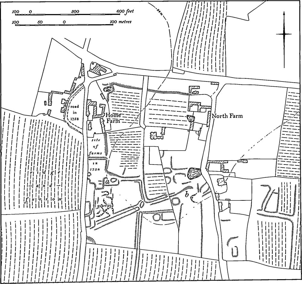
Fig. 80 Upper Heyford (2) Settlement remains
Further E., on the W. side of the eastern street, is another area of low disturbed earthworks of no coherent form, the S. part of which has been ploughed over at some time ('b' on plan). A quantity of medieval pottery was found here some years ago (local inf.). The two groups of earthworks are linked by a series of shallow ditches, scarps and low banks which may be the boundaries of former closes. Fieldwalking in the arable land S., S.W. and S.E. of the earthworks has failed to produce any evidence of former occupation. (RAF VAP CPE/UK/1994, 1172–3; FSL6603, 2364– 5; CUAP, AMW61)
(3) Cultivation Remains. The exact date of the enclosure of the common fields of Upper Heyford is unknown but Bridges, writing in about 1720 (Hist. of Northants., I (1791), 525), said that 'about eight years ago it was enclosed by the Marquis of Powis'. Ridge-and-furrow of these fields remains on the ground or can be traced on air photographs over large parts of the parish, arranged mainly in rectangular furlongs set either end-on or at right angles to each other. Broad ditches or hollow-ways existed in a few places (e.g. SP 664591), passing between the furlongs, but their date is unknown and they may relate to a period after enclosure. (RAF VAP CPE/UK/1994, 1172–5, 1261–5; CPE/UK/ 1926, 4035–7; FSL6603, 2364–5, 2374–5)