An Inventory of the Historical Monuments in the County of Northamptonshire, Volume 4, Archaeological Sites in South-West Northamptonshire. Originally published by Her Majesty's Stationery Office, London, 1982.
This free content was digitised by double rekeying. All rights reserved.
'King's Sutton', in An Inventory of the Historical Monuments in the County of Northamptonshire, Volume 4, Archaeological Sites in South-West Northamptonshire, (London, 1982) pp. 92-96. British History Online https://www.british-history.ac.uk/rchme/northants/vol4/pp92-96 [accessed 26 April 2024]
In this section
35 KING'S SUTTON
(OS 1:10000 a SP 43 NE, b SP 43 SE, c SP 53 NW, d SP 53 SW, e SP 54 SW)
The parish is large, covering some 1700 hectares, and lies against the county boundary with Oxfordshire, on land sloping generally S. W. to the R. Cherwell, but with a series of small tributary streams producing a rolling landscape of deep valleys with wide flat ridges between them. Apart from some small outcrops of Northampton Sand in the S.E. where the land rises to 130 m. above OD most of the higher parts of the parish are on Marlstone Rock. Elsewhere the underlying Lias Clay has been exposed by the down-cutting of the streams.
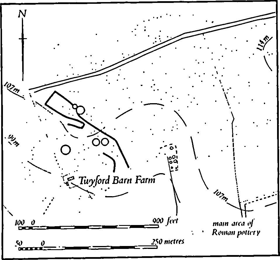
Fig. 81 King's Sutton (6) Prehistoric and Roman Settlement
The parish is particularly rich in archaeological remains of all periods. Some of these are of considerable interest in themselves, but an attempt has also been made to see them in the broader context of a continuously developing landscape (F. M. Brown and C. C. Taylor, 'Settlement and Land Use in Northants.' in BAR, International Series (Supplementary), 68 (1978), 77–89). The present boundaries of the parish are relatively modern; in the 19th century Little Purston and its surrounding land was part of Newbottle parish, and the E. part of Newbottle was a detached part of King's Sutton.
Prehistoric and Roman
Bronze Age inhumations and a palstave often said to be from King's Sutton were in fact found in Aynho parish (see Aynho (1)).
A polished flint axe was discovered in 1966 somewhere in the parish (Oxoniensia, 33 (1968), 138; Ashmolean Museum). An iron object described as a 'cultrum or chopper' together with an 'iron knife or spatula' and a Roman coin of Vespasian were discovered at Astrop in the 19th century (JBAA, 17 (1861), 70; VCH Northants., I (1902), 216).
d(1) Enclosure (?) (SP 507336), in the S. of the parish, on Marlstone Rock at 95 m. above OD. Air photographs (NCAU) show a curved ditch which may be part of a large circular or oval enclosure about 30 m. wide.
c(2) Round Barrow (SP 50193864), N. of the village and a little S.W. of Buston Farm, on the summit of a rounded hill of Marlstone Rock, at 122 m. above OD. The barrow was destroyed without excavation in about 1910 during ironstone-mining. It was about 33 m. in diam., and about 1 m. high, and apparently contained a crouched burial. (G. Baker, Hist. of Northants., I (1822–30), 703; Oxford Arch. Soc. Reps., 56 (1910), 36; OS Record Cards)
c(3) Round Barrow (SP 50253860), immediately S.E. of (1) and in a similar position. It was destroyed by ironstone-mining in about 1910 but no finds are recorded from it. (G. Baker, Hist. of Northants., I (1822–30), 703; Oxford Arch. Soc. Reps., 56 (1910), 36; OS Record Cards)
c(4) Round Barrow (?) (about SP 508382). described by Baker (Hist. of Northants., I (1822–30), 703) as being in a very prominent situation on High Thorn Hill above 'Buston House'. High Thorn Hill has been identified but no indication of a barrow survives. Much of the area formerly had ridge-and-furrow on it. (RAF VAP CPE/UK/1926, 5208– 9)
c(5) Neolithic and Roman Settlement and Burials (centred SP 505387), lay on Marlstone Rock, on land sloping generally N. between 114 m. and 122 m. above OD and close to the round barrows (1) and (2). The area was worked for ironstone between 1909 and 1911 and numerous discoveries were made. In 1910 at least 12 extended skeletons were found and in 1911 four more burials, two of which were crouched inhumations. Numerous pits, Neolithic and Roman pottery, Roman coins from Claudius to Constantine the Great, flint scrapers and a polished axe were also discovered then. The Roman pottery was said to extend over a wide area and several complete pots are recorded (Oxford Arch. Soc. Reps., 56 (1910), 35–8; 57 (1911), 12–17; 58 (1912), 114–8; OS Record Cards). Some of the Neolithic pottery is said to have been found in pits and has been described as 'of Peterborough type' (PPS, 30 (1964), 378). Most of the finds are in the Ashmolean Museum.
For Anglo-Saxon discoveries at this site, see (8).
a(6) Prehistoric and Roman Settlement (centred SP 491375; Fig. 81), lies S.W. of (4), in the N.W. of the parish, on Marlstone Rock sloping S.W. towards the R. Cherwell, between 115 m. and 90 m. above OD. The area, covering some 20 hectares and known as Blacklands, has long been known as a Roman settlement, for Morton (Nat. Hist. of Northants. (1712), 531) recorded 'Roman money' found in Blacklands Furlong. Before 1825 skeletons 'in rude cists of sarson stones' were found in the area and in 1825 a 'cinerary urn' containing a cremation, two other skeletons and coins of Hadrian and Marcus Aurelius were discovered (G. Baker, Hist. of Northants., I (1822–30), 703). Before 1841 Roman coins, including some silver ones, foundations of buildings, mill-stones and at least four more skeletons with 'rough headstones' were found and the existence of cropmarks was noted. In the W. part of the site a skeleton associated with a bone pin and 'celt of serpentine' is also recorded (A. Beesley, Hist. of Banbury (1841), 33). The 'celt' is probably the otherwise unlocated jade axe from King's Sutton (Ashmolean Museum; PPS, 29 (1963), 163, No. 34). A fragment of bronze, possibly part of a spearhead, was ploughed up in 1964 to the N. of the site (SP 48873795; BNFAS, 3 (1969), 1). Recent fieldwalking has produced Roman pottery from over a wide area but concentrated mainly at the W. end of the site (OS Record Cards). This pottery is mainly of 3rd to 4th-century date.
Air photographs (in NMR) show, rather indistinctly, at least five small circular features as well as a number of ditches which are probably parts of enclosures. Another cropmark visible on air photographs (also in NMR) passes to the N. of the site (not shown on plan) and is described as an 'early road' (Northants. Archaeol., 8 (1973), 26). It appears to be an abandoned ironstone tramway.
a(7) Roman Settlement (SP 496364), lies immediately N. of the N.W. part of King's Sutton village, above the flood-plain of the R. Cherwell, on clay at 85 m. above OD. Roman coins of Tetricus, Claudius II and Constans are recorded as having been found in the area known as Lake Meadow before the early 19th century (G. Baker, Hist. of Northants., I (1822–30), 703). A skeleton is also said to have been found there (Whellan, Dir., 486) and more recently pottery of the 3rd century has been found at the N.E. corner of the area during building work.
For Roman pottery at Walton, see (10) below.
For possible Roman Roads 56a and 161a, see Appendix.
Medieval and Later
c(8) Saxon Burial (SP 508389), lay to the N.E. of Buston Farm, apparently on the edge of the Neolithic and Roman settlement (5). In 1910–11 a burial with spearheads, said to be Saxon, was discovered during ironstone-working (Meaney, Gazetteer, 192; OS Record Cards).
(9)–(11) Medieval Settlements (Fig. 82). In late medieval times the parish contained a number of discrete settlements, King's Sutton itself, Upper Astrop (9) and Lower Astrop, Great Purston (11), Little Purston then a detached part of Newbottle parish, and Walton (10). Each had its own associated land unit except for Upper and Lower Astrop which shared one. The possible implications of this settlement pattern have been published elsewhere (F. M. Brown and C. C. Taylor, 'Settlement and Land Use in Northants.' in BAR, International Series (Supplementary), 68 (1978), 77–89).
c(9) Settlement Remains (SP 510374), formerly part of Upper Astrop, lie at the N. end of the hamlet, on clay at 110 m. above OD. A number of low banks, presumably abandoned closes, lie around the existing farmstead. (MVRG, Report, 20–21 (1972–3), 6; RAF VAP CPE/UK/1926, 2209–10)
d(10) Deserted Village of Walton (SP 506346; Fig. 83), lay in the S. of the parish, alongside a small stream on clay at 90 m. above OD. The village is first recorded in Domesday Book in 1086, but its name may be derived from Wēala-Tun, i.e. the farm of the serfs, Welsh or Britons (PN Northants., 58). In 1086 Domesday Book lists Walton as three small manors with a total recorded population of ten (VCH Northants., I (1902), 308, 324, 326). In 1301 the Lay Subsidy lists 17 people in Walton paying tax (PRO, E179/155/31) and the village is mentioned as an independent vill in the Nomina Villarum of 1316. In 1487 five houses there were destroyed by John Goylyn who also enclosed 200 acres of land. A few years later in 1506 there were still ten houses in existence, but in 1537 Richard Fermor was prosecuted for carrying out further enclosures and by the early 18th century Bridges (Hist. of Northants., I (1791), 180) said that there were only two houses, both of which still remain. There are records of a former chapel at Walton, but this was in ruins by the 16th century and only the name Chapel Field marked it by the early 18th century (K. J. Allison et. al., The Deserted Villages of Northants. (1960), 47). The remains of the village survived until 1960 when they were almost completely destroyed and the area ploughed up; the accompanying plan (Fig. 83) has been compiled from air photographs. From the latter it seems that the earthworks were never well preserved and that few house-sites were visible. Nevertheless the village was of considerable interest in that it appears to have lain largely on one side of its main street, a layout recorded elsewhere in the county. The principal feature of the site was the street, a broad hollow-way which ran parallel to and S. of the stream. At its N.E. end it met at right angles another track which crossed the stream from N.W. to S.E. The adjacent ridge-and-furrow extended up to the S. side of the main hollow-way so that with the exception of one small ditched enclosure all the visible earthworks of former occupation lay between the N. edge of the hollow-way and the stream. The earthworks, though much damaged by later activity and the existence of two farms, appear to have consisted of small rectangular embanked closes and long roughly parallel scarps. To the E., beyond the 'crossroads' and close to the stream, there was a large pond 50 m. long and 15 m. wide cut down into the hillside except at its W. end where there was a large dam. On the N. side of the stream there seem to have been few remains except for parts of two hollowways or terrace-ways. A considerable amount of medieval pottery, mainly of the 13th and 14th centuries, together with a few sherds of Roman wares, has been discovered in the area of the former earthworks. (RAF VAP CPE/UK/ 1926, 4208–9; CUAP LN50, SA12, AGV33, ANT74)
c(11) Deserted Hamlet of Purston (SP 518396; Figs. 82 and 89), lies in the N.E. of the parish, on Marlstone Rock at 114 m. above OD. Neither the situation of the hamlet nor its tenurial relationship with adjacent settlements can be fully explained: The hamlet lies against the parish boundary with Newbottle, so that the present manor house and another hamlet, also apparently called Purston (Newbottle (4)), must have been contiguous with this hamlet. Each of these settlements had its own land unit but, in addition, the settlement of Little Purston, also with its own land unit and once a detached part of Newbottle parish, lay to the W. Little Purston is and probably always was a single farm. Because of this complexity it is difficult to interpret the surviving population statistics for the medieval period.
Purston is first recorded in 1086 when Domesday Book recorded it as two small manors. One, held by William de Cahagnes of the Count of Mortain, was assessed at half a hide and had only one bordar and is perhaps to be identified as the single farm of Little Purston. The other manor, held by Robert de Statford, was assessed at half a hide and one fifth of a hide and had a recorded population of six. It may represent the other two Purstons combined, though this is not certain (VCH Northants., I (1902), 326 and 334). It is clear however, that the total figure of seven refers to three separate settlements and the same probably applies to the population given in the later records. In 1301, 16 people at Purston paid the Lay Subsidy (PRO, E179/155/ 31). In 1495 three land owners combined to destroy six houses and enclose and convert 280 acres of land to pasture. In 1524 only five people paid the Lay Subsidy (PRO, E179/ 155/134) but Bridges, writing in the early 18th century (Hist. of Northants., I (1791), 180) still described it as a hamlet. Today, with two occupied houses in the King's Sutton part of Great Purston, the manor house in the Newbottle part and Little Purston Farm, there are still some 20 people living there. (K. J. Allison et. al., The Deserted Villages of Northants. (1966), 45).

Fig. 82 Farthinghoe, King's Sutton and Newbottle Medieval settlements and estates
The remains of Purston in King's Sutton parish lie immediately N. of the curving parish boundary and N.E. of the Manor House. They consist of an irregular arrangement of small rectangular paddocks or closes bounded by low banks and scarps nowhere above 0.5 m. high but form no coherent pattern unless the present parish boundary was formerly a through road. There is a little evidence for this at the E. end of the site where a possible hollow-way, cut into by later quarrying, can be seen as well as what appears to be the N. side of the hollow-way further W. along the parish boundary. If this feature was indeed a street then the hamlet of Great Purston consisted of houses on both sides of a single street but the houses on each side lay in different parishes (now King's Sutton and Newbottle). Moreover, each side of the hamlet had its own land unit. For the former earthworks S. of the parish boundary, see Newbottle (4). (RAF VAP CPE/UK/1926, 4209–11)
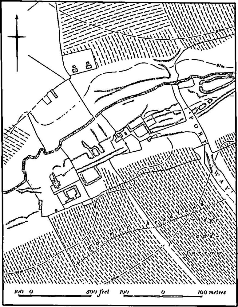
Fig. 83 King's Sutton (10) Deserted village of Walton
a(12) Hollow-Way (SP 495365), lies immediately N. of the N.W. part of the village of King's Sutton and N. of the Roman settlement (7). It runs E.-W. across the slope between the road to Banbury and the flood-plain of the R. Cherwell. Probably because of the Roman coins and skeletons discovered close by, the site has been described as an 'entrenchment' (G. Baker, Hist. of Northants., I (1822–30), 703; A. Beesley, Hist. of Banbury (1841), 35) but the feature is no more than an ancient hollow-way some 12 m. across and 1.5 m. deep passing between ridge-and-furrow and presumably giving access to the river. It has now been partly destroyed by infilling. (RAF VAP CPE/UK/1926, 2208– 9)
(13) Cultivation Remains (Fig. 82). The common fields of King's Sutton village were enclosed by an Act of Parliament of 1804 (NRO, Enclosure Map, 1805). The area affected by this Act was entirely confined to the W. part of the modern parish, the land belonging to King's Sutton itself. It is not clear from the Enclosure Map whether parts of this area were already in old enclosures before 1804. Ridge-and-furrow of these fields exists on the ground or can be traced on air photographs only in a few places. It is almost completely absent on the higher ground and can only be seen along the sides of the Cherwell valley and its tributaries N. and S. of the village where the Lias Clay outcrops. It is arranged in end-on and interlocked furlongs of normal medieval type.
The date of the enclosure of the common fields of Upper and Lower Astrop is unknown, though it was presumably before the 18th century. Ridge-and-furrow of the fields can be traced on air photographs over much of the area of the land attributable to Astrop, but little now survives on the ground. The pattern is almost entirely recoverable in the area of Astrop Park, between Upper and Lower Astrop, where large rectangular end-on furlongs are visible, many with reversed-S curves and almost all running E.W. Among the features of interest here are the sudden changes of ridge width from 4 m. to 10 m. within one furlong (SP 505368) and a broad hollow-way passing between end-on furlongs (SP 507373). In the N. of the land of Astrop, around Buston Farm (SP 505387), there was formerly another broad track up to 40 m. wide and deeply hollowed in places, curving up the hillside. To the E. of it (SP 505388), within a normal furlong of reversed-S ridge-and-furrow 7 m. wide, was one unusual ridge 140 m. long which tapered from 16 m. wide at its S.W. end to 9 m. wide at its N.E. Elsewhere in this area ironstone-mining and later cultivation had destroyed all the ridge-and-furrow before the earliest air photographs were taken.
The common fields of the deserted village of Walton (10) were at least partly enclosed in 1487 when 200 acres of land were converted to pasture. By 1506 only 40 acres of arable existed at Walton and there were 500 acres of pasture (K. J. Allison et. al., The Deserted Villages of Northants. (1966), 47). As a result of modern destruction, ridge-and-furrow of these fields can be traced only on air photographs. It was arranged in end-on and interlocked furlongs. To the S. of the former village (SP 502341– 509343) groups of two or three former end-on furlongs had been joined together by later ploughing over the intervening headlands, producing new furlongs up to 350 m. long with triple reversed-S curves. This ploughing may be post-medieval in origin.
The exact date of enclosure of the land attributable to Great and Little Purston (11) is not known. In 1495, 280 acres of land there and in Newbottle parish were enclosed (K. J. Allison, op. cit., 45) and the rest was probably converted to pasture around the same time. Certainly most of it was divided into hedged fields by the mid 19th century (NRO, Tithe Map of King's Sutton, 1847). Very little ridge-and-furrow survives on the ground, owing to modern cultivation, but much is visible on air photographs. It is all arranged in end-on and interlocked furlongs but characterized by rather small furlongs. Evidence for the joining up of former end-on furlongs is visible as over-ploughed headlands in the N. of the area (SP 516398). (RAF VAP CPE/ UK/1926, 2208–11, 4207–10, 5204–12; CPE/UK/1929, 3165– 71; 106G/UK/1488, 3231–5, 4269–73)