An Inventory of the Historical Monuments in the County of Northamptonshire, Volume 5, Archaeology and Churches in Northampton. Originally published by Her Majesty's Stationery Office, London, 1985.
This free content was digitised by double rekeying. All rights reserved.
'Duston', in An Inventory of the Historical Monuments in the County of Northamptonshire, Volume 5, Archaeology and Churches in Northampton(London, 1985), British History Online https://www.british-history.ac.uk/rchme/northants/vol5/pp249-266 [accessed 30 April 2025].
'Duston', in An Inventory of the Historical Monuments in the County of Northamptonshire, Volume 5, Archaeology and Churches in Northampton(London, 1985), British History Online, accessed April 30, 2025, https://www.british-history.ac.uk/rchme/northants/vol5/pp249-266.
"Duston". An Inventory of the Historical Monuments in the County of Northamptonshire, Volume 5, Archaeology and Churches in Northampton. (London, 1985), British History Online. Web. 30 April 2025. https://www.british-history.ac.uk/rchme/northants/vol5/pp249-266.
In this section
7 DUSTON
(OS 1:10000 aSP 75 NW, bSP 76 SW)
The parish, roughly rectangular in shape and covering some 767 hectares, lies immediately to the W. of Northampton and rises gradually N.W. from a narrow front on the R. Nene at 59 m. above OD to a height of 108 m. above OD towards its W. end. Boulder Clay on the high ground to the W. is bordered by a belt of Blisworth Limestone and Estuarine Series deposits to the W. and E. with Northampton Sands to the N., E. and S. of this. Head, sand and gravel and alluvium are found on the valley bottom.
The parish was once exceedingly rich in archaeological remains but unfortunately most of it is now developed. The extensive areas of prehistoric settlement, the Romano-British 'small town' and the Anglo-Saxon cemetery have largely been destroyed through 19th and early 20th-century ironstone quarrying and the site of the Augustinian Abbey of St. James is now built over.
Prehistoric and Roman
b(1) Pleistocene Remains, Palaeolithic Finds. Several mammoth teeth and fragments of mammoth tusks have been found in the area of the Weedon Road gravel pits (area of SP 734602; NM; NDC P154). Three palaeolithic hand-axes have been recorded from the Weedon Road gravel pits since 1965 at SP 735604 (NDC P200), SP 734602 (NM; NDC P154) and SP 730599 (NM; NDC P117). A number of hand-axes and flake implements found between 1904 and 1906 are also recorded from the parish (NM; NDC P146A).
ab(2) Mesolithic - Early Bronze Age Settlement (SP 72386085 - SP 72836083 - SP 73506041 - SP 72505986). Between 1904 and 1912 approximately 25,000 worked flints including retouched implements, flakes, blades and cores were collected from the topsoil over about 70 hectares, chiefly S. of the Weedon Road. The exact provenance of many of these finds is not recorded, but the greatest concentration appears to have been within an area centred around SP 731605. Amongst the retouched implements in Northampton Museum known or thought probably to be from this site are types diagnostic of mesolithic, neolithic and early Bronze Age industries. The numbers and density of finds indicate a domestic settlement or settlements from at least the neolithic period onwards.
Mesolithic Finds
Approximately 5 per cent of the retouched implements in the recorded assemblage are microliths. These are almost all backed blades, backed points and obliquely blunted points and include hardly any of the more developed geometric types. Twenty-six per cent of the unretouched component consists of small blades of the kind particularly, though not exclusively, characteristic of mesolithic industries. A mesolithic tranchet axe is recorded from around SP 728604.
Neolithic Finds
Many of the retouched pieces could be of earlier neolithic date, although the types are known to have continued in use into later periods. These include leaf-shaped arrowheads (5 per cent of the retouched component), 'laurel leaf' points (1 per cent) and fragments of polished flint axes. A polished stone axe (Group VI, Gt. Langdale; NM) recorded in 1903 may also be from this site (NM; NDC P251).
Later Neolithic/Early Bronze Age Finds
Specifically later types include petit-tranchet derivative arrowheads (3 per cent of the retouched component), barbed-and-tanged arrowheads (4.5 per cent) and tanged arrowheads (1.3 per cent), plano-convex knives (0.7 per cent), straight-edged knives with bifacial or unifacial edge retouch (0.6 per cent) and also a perforated stone macehead (George 1916, 18 no. 147; Wells 1931–3, 5; PM; NM; NDC P98, 145, 146). During archaeological excavations in 1973 centred on SP 72706039 more than 100 flint flakes, blades and cores were found on and around the site. They include several small blades of mesolithic type with microlithic retouch (NM; NDC P126, 166, R113). During archaeological excavations in 1974–5 at SP 732603 over 500 more worked flints were recorded, some of them associated with pits and post-holes which included a possible hut setting. The majority of the diagnostic pieces in the assemblage are of later neolithic type, although there are at least one microlith and several small blades (NDC R101). Sixty-six flint flakes, blades, cores and retouched implements, including a microlithic point, were found in 1977 at SP 726604 during trial trenching along the line of Upton Way (NDC R129).
Other neolithic/early Bronze Age implements recorded at various times include a flint axe (SP 73366132; NM; NDC P36, 227), a neolithic polished stone axe (Group 14) at St. James' End (c. SP 7460; NM; NDC P252), a broken stone wristguard of Beaker type (SP 73076002 but in topsoil brought from c. SP 730605; Northamptonshire Archaeol 9 (1974), 83; NM; NDC P112), and two barbed-and-tanged arrowheads (SP 719620; NM; NDC P159. SP 723625; NM; NDC P195, 201).
Finds of Indeterminate Date
Flints have also been found at SP 71656148 (NM; NDC P168), SP 72266093 (NM; NDC P170), SP 72756022 (NM; NDC P167), SP 728601 (NM; NDC P166), SP 73286040 (NM; NDC P247), SP 73316042 (NM; NDC P249), SP 73336040 (NM; NDC P248), SP 734602 (NM; NDC P154) and SP 73556125 (NM; NDC P221).
ab(3) Mounds(?) (c. SP 74406000), on alluvium at approximately 60 m. above OD. In 1904 George (1903–4, 280) recorded 'Walking as far as the "Harborough Arms" the party turned to the left towards Mr. Beesley's Mill to inspect two tumuli or barrows in a field between the Mill and the main line of the L. and N.-W. railway . . . Our Party, after inspecting these two mounds, returned to cross a field immediately on the north of Mr. Beesley's house to look at a third, and following the footpath towards Duston Mill a fourth barrow was visible'. None of the 'barrows' has survived development (NDC P6).
b(4) Enclosure and Trackway (SP 708626), on N.W. edge of the parish on Estuarine Limestone at 102 m. above OD. An aerial photograph (not seen by NDC or RCHM) showed a double-ditched enclosure and trackway probably of Iron Age or Roman date (Northamptonshire Archaeol 12 (1977), 229; NDC A54).
b(5) Roman Settlement (centred on SP 729605), lay on either side of the Weedon Road. The site, on a S.-facing slope, dips from 76 m. above OD on Northampton Sands through head and glacial sand and gravel to alluvium in the river valley at 60 m. above OD.
Introduction
The earliest reference to finds of Roman material in Duston was published by Wetton (1849, 243) who wrote that 'four interments were discovered recently in lowering the turnpike road; fragments of Samian ware, black urns and skeletons were found'. In 1854 'a vase' and about 37 Roman coins came to light (VCH Northamptonshire I, 197). The following year saw the official opening of the Duston Iron Ore Company and the beginning of over half a century of very important archaeological discoveries in the area. Finds of major importance prior to 1875 coming from the angle between the Duston Road and the Weedon Road were recorded by Samuel Sharp, a local antiquarian (1875, 125). The records of the quarrying (NRO) show that work generally progressed from this angle fanning out to the W. and S. with occasional finds of Roman material continuing until the turn of the century, when George wrote 'Of late years few Roman articles have been found, but for the last two years the men have been unearthing remains belonging to the succeeding period of the Anglo-Saxons' (1904, 281; see below (7)). It is unlikely that very much of the archaeology of Roman Duston has survived quarrying and development although excavation and field-work in recent years has added somewhat to the picture derived from 19th-century sources.
The Settlement
The precise or even general nature of the settlement at Duston will probably never be known since detailed archaeological records were not made during the period of ironstone quarrying. It would appear, however, that the settlement covered at least 20 acres.
A major problem relates to the date and nature of the 1st-century occupation on the site. At least 20 Ancient British coins have been recovered from Duston. Catuvellaunian coins predominate with five of Tasciovanus (20 BC-AD 10), at least nine of Cunobelinus (AD 10–40) and two of Andoco (AD 5–15). There are also four Dobunnic coins (Allen 1961, 223, 233–4, 236, 248, 251, 253; Gunstone 1971; Haselgrove 1978, 64; NM coin index; NDC R101). Among the brooches are approximately 13 of Colchester type, six of Aucissa/Hod Hill type and five of Langton Down type (NM; NDC R101; brooches examined by D. Mackreth). Although the coins were minted before the Roman Conquest they continued to circulate during the Conquest period. Similarly many of the brooches may have been manufactured before AD 43 yet they were still in use after that date. Again with the pottery, although 'Belgic' types are fairly common, little is definitely pre-Conquest (see below SP 73256071). The evidence certainly points to fairly extensive settlement before AD 60 and at least some occupation before AD 43. The nature and extent of the pre-Conquest settlement is, however, uncertain as is that immediately after the Conquest.
There is nothing specifically military among the finds yet the situation of Duston mid-way between Bannaventa and Irchester suggests that a military presence is at least a possibility.
In an article published in 1871 Sharp wrote that 'no indications of domestic habitation - no tesserae, no foundations of houses - have yet been discovered' (1871a, 3), but he had previously written in 1862 that together with pottery 'were numerous black and white tesserae . . . Undoubtedly near this spot stood a Roman house;' (1861–2, 222). A letter written in 1939 (NM Donations File) records the memory that 'in the 1880's a large box of mosaics from a pavement' was taken to the museum but unfortunately this material cannot be traced. Nevertheless, fragments of flue tile, roof tile, T-clamps and a window grille imply that there must have been Romanised buildings on the site and it must be noted that Sharp records 15–20 wells in the area (1871a, 4). Finds from the period of ironstone quarrying include over 1000 coins (George 1903–4c, 18) and 3rd-century counterfeit coin moulds (Sharp 1871b; Boon 1974, 127), a silver brooch, a bronze bust of Lucius Verus (George 1904, 5) and a collection of pewter (Kennett 1976, 19) as well as a large quantity of more mundane bronze and iron-work and pottery (NM; NDC R9).
Excavations by Northampton Development Corporation's Archaeological Unit in 1974–6 to the S. of Weedon Road in the area of SP 731603 recovered definite evidence of structures. A metalled road ran S.W.-N.E. across the site. At SP 73156035 the road was flanked by ditches containing 1st-century pottery. The area was badly disturbed but evidence of a timber building and a later stone building survived to the S. of the road. At SP 73116044 a series of gullies and ditches, probably 1st and 2nd century in date was overlaid by a stone structure 12 m. × 6 m. dating to the 3rd or 4th century. Immediately to the E. and set approximately at right angles was another stone building 17+ m. by 9 m.. Two decapitated burials lay just to the N. Traces of further stone buildings were noted during topsoil stripping at SP 73196045 and SP 73216051. A double burial lay just to the S.W. of the first of these buildings. A series of ditches associated with at least 12 burials, at least two of which were decapitated, was centred on SP 73256028. A small hoard of 45 billon radiates, contained in a pot was found at SP 73156044. The hoard dates to within a few years of AD 280. The evidence from the excavation and watching briefs does not indicate a densely settled regularly planned urban centre but rather a loosely disposed 'service centre' for the surrounding countryside and the fragmentary structural remains suggest possible formalisation, at least of this area of settlement, and rebuilding in stone, not earlier than the second half of the 3rd century.
Observations have been made at a number of locations and casual finds recorded. In 1977 trial excavations ahead of road development at SP 726604 revealed a few cut features of 4th-century date together with a scatter of earlier pottery (NDC R129). In 1973 a service trench centred on SP 73256071 contained cut features associated with pottery of 'Belgic' type, including some certainly pre-Conquest, and also some later Roman sherds (NDC P75). A Roman sherd was found in the area of SP 734602 (NM; NDC P154). Twenty-six Roman sherds were found in the area of SP 73306029 (NDC R183), 140 sherds at SP 73286035 (NDC R182), 12 sherds at SP 73206044 (NDC R181) and 235 sherds at SP 73076046 (NDC R180) (BNFAS 7 (1972), 20). A denarius of Trajan was found at SP 73216038 (Northamptonshire Archaeol 11 (1976), 192; NDC R146). A Roman pot was found at approximately SP 735606 (NDC R10). Roman sherds and a brooch were found at around SP 732606 (NM; NDC R64, 220). Six 3rd to 4th-century coins were found at approximately SP 734609 (Northamptonshire Archaeol 13 (1978), 181; NDC R161). A Roman coin was found in Abbots Way (centre point at SP 73566073; NM; NDC R65). A 'barrowful' of sherds and a few coins were found in a pit at SP 73556104 (OS Records; NDC R237). A sestertius of Faustina Junior was found at SP 73636090 (Northamptonshire Archaeol il (1976), 193; NM; NDC R147). A 3rd brass of Magnentius was found in Holyrood Road (centre point at SP 73806111; NM; NDC R84). A 4th-century coin was found in the area of SP 732614 (J Northamptonshire Nat Hist Soc Fld Club 31 (1949), 35; NM; NDC R131). Two sherds of Samian ware were found in St. Luke's churchyard (centre point at SP 72506094; NDC R199). Walls and Roman and medieval pottery were recorded in the area of SP 726608 in 1978 (NDC R141). A coin of Antoninus Pius was found in a garden in Old Duston (c. SP 7261) before 1895 (Northamptonshire Chronicle 23 July 1894; NDC R236). Three grey ware sherds were found at SP 72506035; BNFAS 7 (1972), 20; NDC R178). A 4th-century minim was found in St. James' allotments (area of SP 741606; NM; NDC R174). Two coins including one of Constantine Constantinopolis were reputedly found on the site of the old tram-sheds (centre point at SP 74176049) in c. 1900 (NM; NDC R173). A late 1st-century or early 2nd-century coin was found in St. James' Mill Road (area of SP 744603; NM; NDC R82). An antoninianus of Probus was found in Northfield Road (centre point at SP 71926200; NM; NDC R185).
The Cemeteries
Wetton had noted in 1849 the discovery of four burials in Duston (1849, 243) and a letter in the Dryden collection, of 16 January 1864 (NPL), records a further 26 orientated skeletons as well as Roman coins and pottery. Sharp discussed the evidence from the early years of quarrying which, as noted above, apparently all came from N. of the Weedon Road, between it and the Duston Road. He noted 'the remains of very many skeletons, and indications of probably a larger number of burials by cremation' (1871a, 3). No records of the exact location and arrangements of these finds survive, all in any case being brought to light through quarrying, but the cemetery apparently had an area 'exceeding nine acres' (George 1903–4b, 297). Sharp described in one instance 'three grave-like excavations' which had been 'arranged upon a semi-radial plan'. They were 'strewn with ashes' and contained 'burnt stones, fragments of what I will provisionally call the Romano-British pottery and a cluster of imitative coins called minimi' (1871a, 7). There is, however, no conclusive evidence of burial in these pits, although they were clearly in the cemetery area.
Excavations between 1974–6, S. of the Weedon Road (see above) uncovered at least sixteen skeletons or parts of skeletons and one cremation (NDC R101). Of particular interest were four burials where the body had been decapitated; these were probably late Roman in date (cf. Harman et al 1981, 166).
In 1908 a stone sarcophagus containing a skeleton but no other finds was discovered in Duston 'on the site of the Roman villa'. The coffin was 'surrounded by roughly built stone walls, 4 feet thick, of white limestone, which seem to have formed some kind of building or chamber, the shape of which has not yet been determined' (Markham 1907–9, 252–4). The form of the burial and the evidence of a funerary structure suggest that this was probably a Roman burial.
There is a large number of complete pottery vessels from Duston in Northampton Museum, many of them 'miniatures' and the excellent state of their preservation suggests that a large proportion of them at least were grave goods.
The relationship of the Roman and Anglo-Saxon cemeteries is obviously of significance, and although the lack of details of the precise location of finds does not make it possible to say a great deal, it is of interest that a Roman lead coffin was found 'in the midst of the Saxon cemetery' in 1903 (see (7)).
The End of Roman Duston
The coin series from Duston ranges from the 1st to the 4th century and includes examples of Honorius and Arcadius which suggests some activity in the late 4th or early 5th century; this is supported by two buckles of this date now in Northampton Museum (Hawkes and Dunning 1961, 50, 52). The presence of a Roman lead coffin within the Anglo-Saxon cemetery (see above; also (7)) perhaps also suggests continuity although the location of the coffin may have been fortuitous. There is, however, nothing else from the Anglo-Saxon cemetery apparently earlier than AD 450 although this is not in itself conclusive as cemeteries of the earlier 5th century appear to have been singularly lacking in grave goods (Clarke 1979, 371). No early to middle Saxon pottery, either domestic or funerary, has been recognised from the area of the Roman settlement.
Medieval and Later
Medieval and post-medieval pottery, tile, iron and glass were found in 1970–1 at SP 71476269 (NM; NDC M34). Walls and Roman and medieval pottery were found in 1978 at SP 726608 (NDC R141).
b(6) Parish Church of St. Luke (SP 725610; fiche Figs. 27, 28; Plate 27)
Development
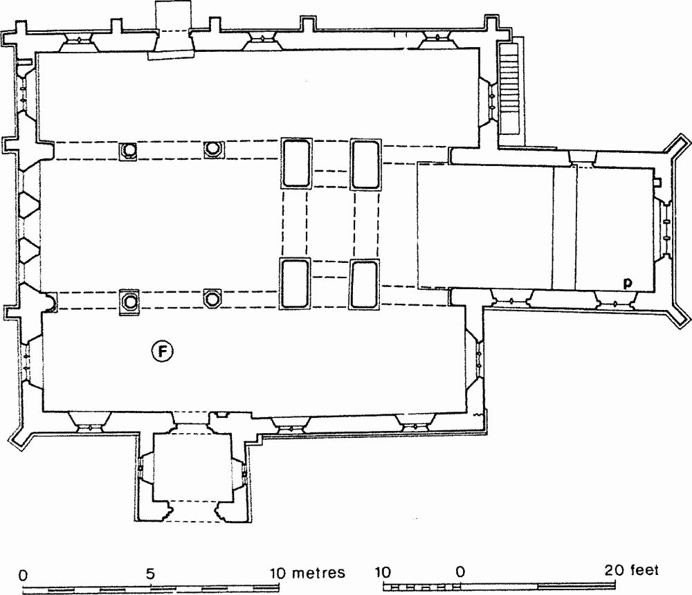
Fig. 27 Parish Church of St. Luke.
The only details of the fabric to be dated to the 12th century are the S.W. respond of the nave and the S. doorway but the plan form, in particular the proportions of the nave and its relationship to the tower, and differences in wall thicknesses indicate the outlines of the 12th-century church. The church may have begun with an unaisled nave, central tower and chancel. The central tower was square, extending to the E. The nave, the S.W. corner of which survives, was slightly wider than the tower. The form of the early chancel is uncertain but it may be significant that the width of the present chancel is slightly less than that of the tower. Thus the church may have resembled the 12th-century church at Barton Seagrave, which has a similar plan, but with the compartments decreasing in width slightly from W. to E. Late in the 12th century a S. aisle was added, the same width as the present aisle but only as long as the nave. The line of its E. wall may be indicated by the change in thickness in the present S. aisle wall. The W. wall of the nave was refenestrated in the 13th century with three large lancets surmounted by a fourth in the gable. The section of the nave at this period is preserved in the W. wall and on the W. face of the tower. The width of the S. aisle and its height as indicated by the S. doorway suggest that the aisle was gabled. In the 14th century the church was extensively rebuilt. The tower was cut back on the E. to a rectangular plan and the N. and S. walls, though now shorter, were thickened to carry a small square belfry. The chancel was extended both to the E. and to the W. to its present length. The W. end occupies the E. part of the site of the earlier tower. The nave aisles were extended to embrace it. The N. aisle appears to have been a new build of the 14th century, the S. aisle being extended to match. In the nave, new arcades were constructed which rise higher than the original nave walls. The walls were therefore raised and a clearstorey formed. The close connection of the church with the neighbouring abbey of St. James, Northampton, which had acquired the church in the 12th century, may explain why, in the 14th century, the chancel was enlarged while the small original nave remained unaltered and the central tower was retained perhaps as a form of screen.

Fig. 28 Parish Church of St. Luke. Development plan.
About 1800 the S. wall of the church was partly rebuilt (Northampton Mercury, 22 Sept. 1863). In 1862–3 there was a partial restoration and in 1865 the aisle roofs were repaired (Northampton Mercury, 22 Sept. 1863; faculty NRO 109P/14)
History
The church was allegedly part of the foundation endowment of St. James' Abbey, Northampton, given by William Peverel II in the 1150's (Franklin 1982, 116, following Dickinson 1950, 125, n.3) but there is evidence to suggest that St. James' was founded somewhat earlier, probably before 1140, as a priory and the original endowment seems to have been only the Peverel land in Duston. The church itself is first mentioned in a grant by Earl Simon, datable to 1148–59 (BL Tib E v f. 2r-v). This charter was almost certainly made by Earl Simon II who died in 1153; hence it seems that the church was granted to St. James' between 1148 and 1153.
The right of the Senlis Earl of Northampton to grant the church is not readily explicable but may be connected with the earl's rights over the minster at St. Peter's, Northampton. That the life interest of Walter de Alto as parson in the church was reserved in an agreement between him and Abbot Ralph (1150–76) (Knowles et al 1972, 178) suggests that it was not new at the date of the abbey's acquisition (Franklin 1982, 116). The abbey appropriated the church in the time of St. Hugh (BL Tib E v f. 51 v) and by the early 13th century the church had a dependent chapel of St. Margaret in St. James' End (9) (Gibbons 1888, 39).
Description
The church consists of a Chancel, central Tower, Nave, North and South Aisles (which run E. to embrace the tower and the W. end of the chancel) and South Porch.
Chancel
At the W. end of the N. wall is an archway into the E. end of the N. aisle. The arch is of two chamfered orders, the inner on polygonal corbels, the outer continuous on the E side but dying into the tower wall on the W. The other opening in the N. wall is a doorway with a two-centred head opening into a vestry, now removed. Its site is indicated by an interruption in the sill moulding which runs around the chancel. The E. window is of three lights with curvilinear tracery and with hood moulds and head-stops both inside and out. In the S. wall are two two-light windows with tracery of a quatrefoil. Under the easterly window is a piscina with a cinquefoil head, sunk chamfered. The arch at the W. end of the S. wall is the same as its counterpart to the N. The 19th-century roof incorporates four corbels carved with musicians, heavily over-painted.
Central Tower
The tower is rectangular in plan within the church in the lower stage but reduced to a square above. The tall E. and W. arches are of two double-chamfered orders, the outer continuously moulded, the inner on polygonal corbels set on twin heads. The N. and S. arches are lower and deeper and are moulded with a simple chamfer. On their internal face the arches are of two orders, the inner order dying into the jambs. The corners of the tower are chamfered to head height, the chamfer being terminated on all but the N.W. angle by a spur and a trefoil. The belfry openings are of two lights with quatrefoils in the heads. On the W. face of the tower is the crease of a steep roof, corresponding to the scar on the W. wall of the nave.
Nave
The N. arcade is of three bays, with double-chamfered arches. Two of the piers have polygonal shafts with moulded capitals of the 14th century. The E. and W. arches end on polygonal corbels set on twin heads. The bays are of slightly different lengths and the arches of different heights. There are no clearstorey windows on the N. side. The E. wall has already been described with the tower. The S. arcade is the same as the N. except that it has a W. respond of a round half-shaft with a round scalloped capital of c. 1200. The shaft is wider than the wall above it and projects 140 mm. to the S. The N. side of the abacus has been cut away for the splay of the W. window. The clearstorey windows are quatrefoils with alternate pointed and rounded foils. In the W. wall are three wide lancets, with wide splays, and a narrow lancet above. On the external face the pronounced change in the masonry between the earlier small rubble and the later squared ashlar outlines an earlier gable. The present nave roof is 19th-century.
North Aisle
The three windows in the N. aisle are of two lights with Y-tracery, probably of the 19th century. The N. doorway has a two-centred head and is sunk-chamfered. The E. window has similar tracery to those in the N. wall but is of three lights; the W. window is the same as the E. An oculus with a chamfered edge, to the N. of the sill of the W. window, is visible externally. It is probably of medieval origin. The N. aisle roof is 19th-century.
South Aisle
The E. window is of three lights of the same design as the E. window of the N. aisle. In the S. wall are three two-light windows similar to those in the N. aisle, apparently entirely 19th-century. The section of the S. wall E. of the porch is 250 mm. narrower than the rest of the wall. Externally it has been refaced. The round-headed S. doorway has two orders of roll-moulded arches carried on shafts with foliate capitals. To the E. of the doorway is a trefoil-headed stoup. The W. window is similar to its counterpart in the N. aisle. In the aisle is a round 12th-century font with a form of fluted ornament around the base of the bowl.
South Porch
The outer doorway has a two-centred arch of two orders carried on shafts with round capitals, apparently of c. 1300, although the two-light windows in the E. and W. walls are 19th-century. The porch appears to post-date the aisle wall since its E. wall runs into a buttress of the aisle wall.
b(7) Anglo-Saxon Cemetery (?SP 727604), on Northampton Sands at about 83 m. above OD. The cemetery was discovered in 1902, when 'the men who were then working on the further side of Mr. Strike's orchard, found a skeleton with which was associated a large and handsome fibula of an Anglo-Saxon character, two iron knives and some amber beads . . . During the last two years more than a hundred skeletons have been disinterred; with a great number of them nothing has been found, but from other graves, brooches, personal ornaments, spear heads and bosses of shields have been obtained;' (George 1903–4a, 281). In 1919 the same author noted that 'but few cases of cremation' had been found 'but from the other burials were taken 59 brooches, 17 necklaces of amber, glass and earthenware, the largest one having beads, 7 wrist clasps, 1 girdle hanger, 24 spear heads, 22 knives, 12 bosses of shields and the remains of a wooden bucket with bronze bands' (George 1919, 43). Many of the brooches are of disc, saucer and small-long type of which the date range is mostly between AD 450 and 550 but there is some later material. The discovery of a Roman lead coffin 'in the midst of the Saxon Cemetery' (see above (5)) is intriguing and perhaps suggests continuity from the Roman to the Saxon period but there is no other evidence to substantiate this.
An orchard is recorded immediately to the W. of the pre-1900 quarrying (SP 727604; NRO Map 1162) and it is probable that this is the one referred to. Since the site was also 'about half a mile due W. of the Romano-British site' (Proc Soc Antiq, 2nd ser. 19 (1901–3), 310–14) it was probably on the W. side of the orchard. In 1977 trial trenching and a watching brief on the route of Upton Way, produced no evidence verifying the location but ditches of 4th-century date were noted (see above; SP 72606040; NDC R129). (OS; finds in NM; NDC ASI)
b(8) Site of Augustinian Abbey (probably centred on c. SP 736607), lies to the S. of Weedon Road on Northampton Sands at around 67 m. above OD. A house of Augustinian canons, dedicated to St. James, was founded in the first half of the 12th century by William Peverel. The house was probably originally a priory and subsequently achieved abbey status, for Ralph, who occurs as abbot in 1158 and died in 1177, is referred to on several occasions as the first 'abbot' of St. James (Serjeantson 1905–6b, 244). The canons moved from perhaps initial temporary accommodation into new buildings, including the church, in 1173. The abbey was well endowed, with property in some 60 Northamptonshire parishes in addition to rents in Rutland, Bedfordshire, Leicestershire and at Charing Cross in London. The abbey was suppressed in 1538 when the estate was granted to Nicholas Giffard (Serjeantson 1905–6b).
No remains of the abbey survive upstanding. Baker quotes a deed of enfeoffment of 1637, when the estate passed from the Giffard family, describing a 'mansion house called St. James near Northampton, lately new built upon the ground sometime belonging to the late dissolved abbey . . . of St. James . . . together with the great barn called the abbey barn, with the water-mill, mill-houses, malt-floors, dove-houses, and out-houses thereto belonging . . .' (Baker 1822–34 1, 151). Lee writing in 1715 describes the barn as 'one of the greatest and stateliest barns of England. It had brave stone walls, it was covered with excellent timber and well slated and on the North side by the road there were two porches very large to enter into the barn or carry grain' (1931–2, 68).
'Abbey Land', presumably the extent of the abbey precinct, is marked on a map of 1722 (NRO map 583). A section of the abbey wall on the Weedon Road survived until 1927 (Serjeantson 1905–6b, pl. facing 243; VCH Northamptonshire III, 58). Just to the E. of the junction of Weedon Road with Duston Road, and lying S. of the Weedon road used to be situated 'Fairyard Close', and adjoining it to the W. 'Churchyard Close' (NRO map 4387) probably to be identified as the site of St. Margaret's Chapel (9). Bridges states that a barn and dove-house stood in the close where St. James' fair was held and that this was also thought to be the site of the abbey itself (1791 1, 503). It seems unlikely that the main abbey buildings were situated either in Churchyard Close, at the extreme N.W. of the abbey precinct, or in the area where the fair was held, which was presumably open ground in medieval times; a location a little to the E. at c. SP 736607 is perhaps more probable. 'Abbey Close' (NRO map 4387) was situated at c. SP 738607. The gravestone of Abbot Nicholas de Flore (AD 1334) survives now in Duston Church (Serjeantson 1905–6b, pl. facing 250). Tiles from the site have been recorded (Serjeantson 1905–6b, pl. facing 243; NM) as well as Roman and medieval sherds (OS; NM; NDC M20).
b(9) Site of Chapel of St. Margaret (c. SP 734607?), probably lay close to the junction of the Weedon and Duston Roads. The chapel is first recorded in c. 1227 when Warner was instituted vicar of Duston; he was also to hold the Chapel of St. Margaret which was to have its own chaplain (Rot Welles II, 135). Bequests to the chapel are recorded in the late 15th and early 16th centuries (Serjeantson and Longden 1913, 163). It is not known when the chapel went out of use but it was apparently no longer standing in the early 18th century when Bridges was writing. Bridges states that the chapel was next to a toll house (1791 1, 501) and Baker relates that the site was 'contiguous to the west end of the toll house, and is walled round, and called Church-yard Close' (Baker 1822–30 1, 146). Churchyard Close (NRO map 4387) lay in the extreme N.W. corner of the precinct of St. James' Abbey (cf. NRO map 583 recording 'Abbey Land' in 1722). The Ordnance Survey locates St. James' Abbey in Churchyard Close (OS record cards) but it is unlikely that the main abbey buildings lay in the extreme N.W. corner of the precinct in a restricted area immediately to the W. of the 'Fairyard' (NRO map 4387), presumably an open area and the site of the medieval fair which was held within the abbey precinct. Bridges (1791 1, 503) however seems to indicate that the abbey buildings themselves stood in the close where the fair was held. Wetton (1849, 144) relates that several stone coffins were found there and in 1977 the burial of an adult male and stone blocks possibly from buildings were discovered at c. SP 73556072. It seems most reasonable to follow Bridges and Baker and identify Churchyard Close as the site St. Margaret's Chapel but locate the site of the abbey buildings some distance to the E. (NDC M38).
(10) Cultivation Remains. The common fields of the old parish of Duston were enclosed by an Act of Parliament of 1776. On a map of 1722 (NRO) five separate fields are depicted, though four of these may have been regarded as two. Immediately S. of the village was a small Middle Field with a large Middle Field to the N. of the village. Langdale Field lay N.W. of the village and another Langdale Field to the S.E. of the village. The S. side of the parish was occupied by the large Arbour Field. In the S. of the parish, along the R. Nene were old enclosures and meadows, while the extreme N.W. of the parish was occupied by a large area of heath, though by 1722 this was already divided into hedged fields.
Ridge-and-furrow exists or can be traced on air photographs in a few places within the parish. Four furlongs formerly in Arbour Field can be traced on the S.E. side of the Harlestone Road and N. of Bants Lane (SP 727618 and 731613). Part of another furlong, formerly in the southern Langdale Field, still exists immediately S.E. of the old village centre (SP 727608), while parts of two others in the former northern Middle Field can be traced on air photographs (SP 723613). More isolated patches of ridge-and-furrow exist in the area of the former northern Langdale Field (SP 710618, 712621, 715621). Small patches of ridge-and-furrow are also visible within the area of the former heath (SP 710625, 714625, 722629). (FSL 6565, 1923–6; V58–RAF-1122, 0140–56, 0197–205, 0210–18, 0254–61, 0272–5; CPE/UK/1994, 1252–7)