An Inventory of the Historical Monuments in the County of Northamptonshire, Volume 5, Archaeology and Churches in Northampton. Originally published by Her Majesty's Stationery Office, London, 1985.
This free content was digitised by double rekeying. All rights reserved.
'Kingsthorpe', in An Inventory of the Historical Monuments in the County of Northamptonshire, Volume 5, Archaeology and Churches in Northampton(London, 1985), British History Online https://www.british-history.ac.uk/rchme/northants/vol5/pp300-310 [accessed 30 April 2025].
'Kingsthorpe', in An Inventory of the Historical Monuments in the County of Northamptonshire, Volume 5, Archaeology and Churches in Northampton(London, 1985), British History Online, accessed April 30, 2025, https://www.british-history.ac.uk/rchme/northants/vol5/pp300-310.
"Kingsthorpe". An Inventory of the Historical Monuments in the County of Northamptonshire, Volume 5, Archaeology and Churches in Northampton. (London, 1985), British History Online. Web. 30 April 2025. https://www.british-history.ac.uk/rchme/northants/vol5/pp300-310.
In this section
11 KINGSTHORPE
(OS 1:10000 aSP 76 SW, bSP 76 SE)
Prior to 1900 the parish of Kingsthorpe occupied an area of 748 hectares bounded on the W. by the Pitsford Brook, on the N. by Boughton and Moulton Park, on the E. by Abington and on the S. by Northampton. In 1900 most of the parish was annexed to the municipal borough of Northampton, the remainder being amalgamated with Boughton and Moulton Park. Subsequently, in 1931, the rest of the parish was also absorbed by Northampton.
The parish slopes gently from a height of 121 m. above OD at its N.E. corner to 61 m. above OD in the S.W. where it meets the Pitsford Brook. The S. part of the parish is dissected by a small stream, the Wallbeck, which flows W. into the Pitsford Brook. Kingsthorpe is mainly on Northampton Sands though there are extensive deposits of silts, clays and limestones of the Estuarine Series and Great Oolite Limestone in the extreme N.E. In the W. and S. of the parish the valleys of the Pitsford Brook and of the Wallbeck have cut down through the sandstone allowing the Upper Lias Clay below to outcrop. The junction of the Northampton Sands and the Upper Lias Clay is marked on the W. side of the parish by a series of springs. The old village of Kingsthorpe also lies on the W. side of the parish, overlooking the Pitsford Brook, at 73 m. above OD. A well, called the Kingswell, on the old village green provides a plentiful source of water.
The parish, though it does not possess any outstanding archaeological monuments, is notable, nevertheless, for the number of chance finds from within it, possibly because such a large proportion of its area has been developed during the expansion of Northampton. A number of finds of neolithic objects hints at some form of activity in that period around the area of Kingsthorpe Golf Course (centred on SP 765630) while the large amount of Roman material may also be significant.
Prehistoric and Roman
A palaeolithic implement was discovered at some time before 1949 (SP 76826262; NM; NM Records; NDC P61). A stone or flint axe was found somewhere in the parish before 1906 and worked flints, again unlocated, are also recorded (lost; NM Records). In 1931 a flint axe was revealed during building operations in Raeburn Road (c. SP 765627; J Northamptonshire Nat Hist Soc Fld Club 26 (1931–2), 39; NM; NDC P38) and a stone axe (Group 1) was found on the Links View Estate in the 1960's (c. SP 765633; NM; BNFAS 4 (1970), 5; NDC P67). An adze of dolerite came to light in a garden on Wentworth Way in 1972 (SP 76266303; Northamptonshire Archaeol 8 (1973), 4; NM; NDC P109). Worked flints have been reported from six locations within the parish (c. SP 760624; scrapers; BNFAS 2 (1967), 6; NM; NDC P19. SP 75086480; including a barbed and tanged arrowhead; BNFAS 4 (1970), 2; NM; NDC P102. SP 76206262; NM; NDC P157. SP 74376405; including a leaf-shaped arrowhead; NM; NDC P158. c. SP 768623; barbed and tanged arrowhead; NM Records; NDC P246).
Roman coins have been reported from nine locations in the parish (unlocated; three silver coins of Severus Alexander (AD 222–35) and some later 'third brass' coins; VCH Northamptonshire I, 218; George 1904, 17; NM; NDC R40. SP 76416245; silver siliqua of Gratian (AD 367–83); NM Records; NDC R71. c. SP 745638; 'third brass' of Victorinus (AD 269–71); NM Records; NDC R85. c. SP 749618; Ptolemaic and Constantinian; NM Records; NDC R72. c. SP 748622; two Constantine I (AD 306–37), two Valens (AD 364–78); NM Records; NDC R87. c. SP 76806302; bronze coin, Constantine; BNFAS 8 (1973), 8; NM Records; NDC R140. c. SP 75576331; 3rd-century bronze coin; NM; NDC R188. SP 75016179; 4th-century bronze coin; Northamptonshire Archaeol 13 (1978), 18; NM; NDC R189. c. SP 754636; NM Records; NDC R231).
a(1) Enclosures (centred SP 742644; fiche Fig. 30), N.E. of the Welford Road, on Northampton Sands, at 92 m. above OD. Air photographs (CUAP ZV 17) show an area of some 3 hectares covered with a complex system of cropmarks of enclosures and other linear features (BNFAS 7 (1972), 13; NDC A42).
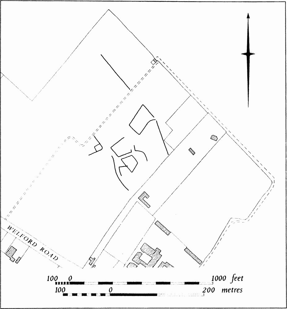
Fig. 30 Enclosures.
a(2) Cropmarks (?) (c. SP 745646), on Northampton Sands, at 102 m. above OD. An air photograph (not seen by NDC or RCHM) is said to show cropmarks in this area (NM Records; NDC A62).
a(3) Cropmarks (?) (c. SP 746642), on Northampton Sands, at 88 m. above OD. An air photograph (not seen by NDC or RCHM) is said to show cropmarks in this area (NM Records; NDC A63).
a(4) Roman Settlement (?) (c. SP 745642), in the N. of the parish, on Northampton Sands, at 87 m. above OD. Pottery, including Samian, was discovered in 1954 during building operations (OS Records; NDC R43). Some medieval pottery was also found.
a(5) Roman Settlement (?) (centred SP 747633), N.E. of the village of Kingsthorpe, on Northampton Sands, at 82 m. above OD. Coins of Tetricus (271–3) and Constantine were found in the area of the Green and Knights Lane in 1921. A further coin of Tetricus and a centenionalis of Constans or Constantius were discovered nearby (SP 74696331) in 1957. A fragment of what is described as a 'mosaic' and yet another coin are recorded from the site of the village school (NM; NM Records; OS Record Cards; NDC R92, 93, 172).
b(6) Roman Settlement (?) (centred SP 754625), in and around Edinburgh Road, in Queen's Park, on Northampton Sands, at 75 m. above OD. Roman coins and pottery, including Samian ware, were found in a well or pit in 1907 in an area where other Roman coins had been found earlier. A skeleton and a coin of Valentinian were discovered near Holy Trinity Church in 1909 together with several large slabs of burnt ironstone and a large quantity of Roman pottery. A silver coin of Eugenius (AD 393–4) was found in the same area in 1953 (J Northamptonshire Nat Hist Soc Fld Club 15 (1909–10), 257–8; Kingsthorpe Grove School Magazine (1907), 6; (1909), 1; (1911), 4; NM; NM Records; NDC R66).
Medieval and Later
Small quantities of medieval pottery have been recorded from five locations in the parish (c. SP 765629; NM; NDC M68. c. SP 747632; NM; NDC M88. c. SP 747635; NM; NDC M319. c. SP 743640; NM; NDC M427. SP 76056241; NM; NDC M435). A medieval jug, unlocated except as 'from Kingsthorpe', is in NM (NDC M352).
a(7) Parish Church of St. John the Baptist (SP 746631; fiche Fig. 31; Plates 30, 31, 36).
Development
The church appears to have been first built early in the 12th century with a nave of a proportion of two squares, on the site of the present nave, and a chancel of one square i.e. with the E. wall running between the double responds. About 1175 the chancel was lengthened by about another square and the N. wall pierced by a two-bay arcade to give access to a chapel. The N. and S. aisles were added to the nave. In the mid-13th century the S. wall of the chancel was pierced by a two-bay arcade, corresponding to that on the N. About 1350 the chancel was lengthened again and a crypt built below the extension. The N. aisle was widened and extended to the E. The same development may have occurred at the same period on the S. but, alternatively, the S. chapel might have remained and been extended later. It was probably also in the late 14th century that the 12th-century chancel arch was removed and replaced by another erected one bay to the E., between but not bonded in with the central piers of the chancel arcades. The relationship between the new chancel arch and the rood screen is difficult to reconstruct since the upper doorways to the rood loft lie one bay further E. The erection of a clearstorey probably post-dated the moving of the chancel arch since the clearstorey followed the stepped outline of the extended nave.
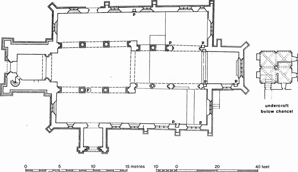
Fig. 31 Parish Church of St. John the Baptist.
There were two major restorations in the mid-19th century, in 1850 and 1863. The former was probably associated with the elevation of Kingsthorpe to full parochial status in 1850 (Kingsthorpe Parish Records no. 157). The chancel was remodelled in 1850, the pitch of the roof being raised and the fenestration altered (Northampton Mercury, 21 Nov. 1863, cf. Plates 30, 36). A four-light Perpendicular E. window was inserted, replacing a square-headed, post-medieval one. The S. window was blocked up but later re-opened. Sir Stephen Glynne saw the church in this transitional state in 1852 (Glynne, ff. 13–16). He described the then chancel arch as 'pointed, and lofty of several orders upon octagonal shafts'. Two plans of 1861 and 1863 confirm both the position and the nature of the chancel arch as well as showing the layout of the furnishing before the restoration of 1863 (NRO Law's Plans Box 55 (1861) ground plan and section; NPL, Dryden Collection. This plan is not that printed in Serjeantson 1904, 152 which is not now to be found in the Dryden collection).
On 29 May 1862 plans were adopted for the restoration of the remaining parts of the church at an estimated cost of £2500 (Kingsthorpe Parish Records no. 160). The nave walls were taken down to the level of the arcades, the westernmost pier on the N. side being entirely renewed and its original capital lost (H.L. Elliot to Northampton Architectural and Archaeological Society: Kingsthorpe Parish Records no. 160 contra the Faculty which makes the new column that further E. in the N. arcade). The late medieval chancel arch was replaced by one on the site of the Romanesque arch and the eastern extension of the clearstorey removed. The S. porch was completely rebuilt. The width of the S. aisle was extended 2 ft. to the line of the S. wall of the S. chapel (Rev. J.H. Glover to Rev. Tuson, 5 March 1888, NPL, Dryden Collection cf. NRO Law's Plans Box 55 (1861)). The entire S. wall of the church was rebuilt. Only the E. wall of the S. chapel is still of medieval origin. The two S. windows of the S. chapel were replaced in the new wall and three windows were inserted in the remainder of the S. wall in place of the previous one. The clearstorey was completely renewed in uniform style using the easternmost two-light window on the S. side as a model. The restoration revealed much evidence of the early structure: the three Norman windows, herringbone walling on the S. wall of the N. chapel, and in the S.W. corner, quoins fixing the height of the pre-clearstorey nave at 17 ft. 3 in. (Northampton Mercury, 21 Nov. 1863). All the roofs and furnishings were renewed and the western gallery removed. (VCH Northamptonshire IV, 85–7).
History
The church at Kingsthorpe was a dependent chapelry of St. Peter's, Northampton throughout the medieval period, only being raised to the status of a separate parish in 1850 (Kingsthorpe Parish Records, no. 157). The first certain evidence of the existence of a church is in a writ of Henry II, dated 1155–8, commanding Bishop Robert Chesney to determine its dependence or otherwise on St. Peter's (BL Royal 11 B ix f. 21 v; Stenton 1929, 4; Franklin 1982, 83–4). The bishop replied that Kingsthorpe was dependent because both burials and baptisms took place at St. Peter's (BL Royal 11 B ix f. 29v; Stenton 1929, 5; Smith, D. 1980, no. 195).
Kingsthorpe is likely to have been the Thorpe mentioned in Bishop Bloet's confirmatory actum to St. Andrew's Priory (1107–23) (Smith, D., 1980, no. 11) since Henry II's writ mentions conditions in the time of his grandfather. If St. Peter's was not in St. Andrew's hands in 1155–8 (as argued in Franklin 1982, chap. 2 passim) but Kingsthorpe was, this might explain the need for Henry II's writ. The large rural estate of more than four hides centred on Kingsthorpe in 1086 (DB f. 219d), including members at Moulton and Weston Favell, may well be further evidence for the extent of the earlier parochia of St. Peter's.
Description
The church consists of a Chancel, North Chancel Chapel (now vestry/organ chamber), South Chancel Chapel, Nave, North and South Aisles, South Porch, West Tower and Spire.
Chancel
At the W. end of the present N. wall is a two-bay arcade of round shafts with square scalloped capitals. The arches are unchamfered and their labels carved with dog-tooth. A round-headed window with a narrow external opening and deeply splayed rear arch has been revealed above the central pier. To the E. of the arcade is a rood loft doorway, followed by a double-chamfered arch of two orders, the outer continuous, the inner on polygonal half-shafts on tall plinths. There is a pointed trefoil-headed recess to the E. of the arch. The four-light E. window has Perpendicular tracery of c. 1850. At the extreme E. end of the S. wall is a tall trefoil-headed piscina with sunk chamfer. To the W. of the piscina is a two-light Perpendicular window, of c. 1863. Below the window is set a further, trefoil-headed piscina. The arch to the S. chancel chapel is like its counterpart on the N. except that the half-shafts are taller. To the W. is a further opening to the rood loft answering to that on the N. The two-bay S. arcade is of Gothic character as opposed to the Romanesque of the N. arcade. The pointed arches are double chamfered, the outer being continuously moulded, the inner carried on polygonal half shafts. The central pier is quatrefoil in section, with three clustered shafts to each 'foil'; the central shaft of each trio is keeled (cf. Great Billing Church). The capitals share the same abacus but are otherwise distinct. The chancel roof is of c. 1850. The E. end of the chancel is raised on a crypt with a central polygonal pier and ribbed vault, probably of c. 1400.
North Chancel Chapel
In the N. wall are a three-light Perpendicular window under a three-centred head and a single-light trefoil-headed recess, now a piscina, with a head corbel, perhaps of a monk, reset above.
South Chancel Chapel
The S. chapel is defined externally by a moulding, which does not continue on the S. wall of the S. aisle. The E. window of the chapel is of three lights with intersecting tracery. In the S. wall are two three-light, straight-headed windows. The lights are trefoil-headed and the spandrels pierced. The fleurons on the external frames were renewed in the 19th century. Under the easterly window is a small piscina, sunk chamfered, with a trefoil head, probably in situ. Between the windows is another recess, with hinges, but also with a drain, perhaps a piscina, with a round head within a pointed outer frame. In the E. face of the projecting wall stub at the W. end is a tall recess, formerly closed with a door. The roof of the chapel is 19th-century.
Nave
The N. arcade is of three bays. The unchamfered arches, decorated with nail head, are carried on round shafts with square, foliated capitals. The W. pier and W. respond were replaced in 1863. A small round-headed window like that in the chancel has been revealed above the E. pier. The clearstorey is of 1863 as is also the chancel arch. The S. arcade is similar to the N. There is a small round-headed window above the E. pier, corresponding to that on the N. side. In the W. wall the tower arch is framed by two large buttresses rising to the head of the arch. The arch is of three orders, the innermost carried on polygonal half-shafts with moulded capitals.
North Aisle
The aisle has consistent mouldings around the walls at sill level, including around the N. chancel chapel. The three westerly windows are of two lights with quatrefoils above. Externally they have ogee hood moulds crowned by carved heads. Below the central window of this group is a trefoil-headed piscina. The N. doorway is continuously moulded with two keeled rolls and a central casement moulding. The E. part of the aisle has already been described under North Chancel Chapel. The W. window is similar to those at the W. end of the N. wall. The roof is of 1863.
South Aisle
The S. wall was completely rebuilt in 1863 2 ft. to the S. of the former wall. The two two-light cusped windows are of 1863. To the W. of them is the S. doorway, continuously moulded with a central casement moulding. The window to the W. of the doorway has a single light with a trefoil above; it is of 1863. The W. window is similar to its counterpart in the N. aisle. The S. porch is a 19th-century replacement of a medieval porch.
West Tower
The tower rises in four stages with set-backs. The upper stages have been refaced. The W. doorway is continuously moulded; the window above is of three lights with quatrefoils above. The tower is crowned by an octagonal spire with three tiers of gabled and transomed lucarnes behind a parapet.
b(8) Hospital of the Holy Trinity (centred on SP 752630), lay to the E. of the medieval village and immediately E. of the main road from Northampton to Market Harborough, on Northampton Sands, at 88 m. above OD. The hospital, founded in 1200 by St. Andrew's Priory, consisted of a hospital building and two chapels; one of these, St. David's Chapel, was already in existence before 1200, but was attached to the hospital on its foundation. The foundation charter provided for a master, two chaplains and six lay brothers and granted that there should be a cemetery for the poor and travellers and those who lived therein and that any parishioners might have burial there if they had chosen it during their lifetime. The hospital was dissolved in 1570 and passed into private hands.
The hospital building, which stood to the N.E. of the junction of Kingsthorpe Grove and Kingsthorpe Road, survived until 1928 when it was demolished. Building foundations and remains of stone coffins, reported to have been discovered in the gardens to the S. and S.E. of the hospital prior to 1897, are probably the remains of the Chapel of the Holy Trinity and the cemetery. The Chapel of St. David stood to the S.E. of the junction of Kingsthorpe Grove and Kingsthorpe Road and was converted at some time before 1893 into two small cottages (Markham 1897–8; Wetton 1849, 89–90; VCH Northamptonshire II, 154–6; IV, 81–2; NDC M29).
b(9) Site of Walbeck Hospital, probably lies in Kingsthorpe Hollow (c. SP 752622), on Upper Lias Clay, at 67 m. above OD. The earliest known reference to the hospital, which was established for lepers, comes in the first half of the 13th century (PRO Ancient Deeds C1935) when it was said to lie 'without the North Gate of Northampton . . . in the parish of Kingsthorpe'. It is not recorded after 1347 (Serjeantson, 1915–16, 25–6; NDC M33).
(10) Cultivation Remains. The common fields of the parish of Kingsthorpe were enclosed by an Act of Parliament of 1766, though no details of their arrangements are known.
In only a few places within the old parish can ridge-and-furrow of these fields be seen on the ground or traced on air photographs in the areas now built over. Part of one furlong running across the contours to a small stream remains on the S.E. side of Kingsthorpe Golf Course (SP 762628) and another curving furlong can be traced to the N.E., alongside the boundaries of Moulton Park (SP 768639). Other small fragments exist at the N.W. end of Kingsthorpe village (SP 745632) and formerly existed to the N.E. (SP 749637). (RAF VAP, V58–RAF-1122, 0041–9, 0074–82, 0099–0109, 0127–37, 0160–8, 0194–5; FSL 6565, 1918–22, 1939–43)