An Inventory of the Historical Monuments in the County of Northamptonshire, Volume 5, Archaeology and Churches in Northampton. Originally published by Her Majesty's Stationery Office, London, 1985.
This free content was digitised by double rekeying. All rights reserved.
'Wootton', in An Inventory of the Historical Monuments in the County of Northamptonshire, Volume 5, Archaeology and Churches in Northampton, (London, 1985) pp. 422-431. British History Online https://www.british-history.ac.uk/rchme/northants/vol5/pp422-431 [accessed 26 April 2024]
In this section
21 WOOTTON
(OS 1:10000 a SP 75 NW, bSP 75 NE)
Wootton parish, 702 hectares in area, lies S. of Northampton and the R. Nene. It is separated from the river for most of its length by Hardingstone parish except at its W. end where it extends N.W. around the W. edge of Hardingstone to gain a narrow access to the Nene. Its boundary on the W. and S. sides is formed by the Wootton Brook while its boundary to the E. is with Preston Deanery.
The sub-soil of the parish is varied, running from Great Oolite Limestone in the N. down through the limestones, clay and silts of the Estuarine Series to Northampton Sands and Upper Lias Clay in the S. with a little alluvium on the sides of the Wootton Brook. The parish slopes gradually from 106 m. above OD at its N. edge until it meets the Wootton Brook on its S. side at 71 m. above OD. The village lies E. of the London Road at 85 m. above OD.
A number of prehistoric and Roman sites are recorded in the parish, the most notable being the Roman Villa (8) just below Hunsbury hillfort (Hardingstone (14)), the site of recent excavations by the NDC Archaeological Unit. This site, together with Wootton (4), forms an extension of the Hunsbury Complex in Hardingstone (6)–(19).
Prehistoric and Roman
Some worked flints were found in about 1962 near Wootton Hall (c. SP 752575; NM; NDC P184). A considerable number of other worked flints, including arrowheads and a small polished flint axe (NM; NDC P47) are said to have been found 'in the fields below Hunsbury' and have been located in Wootton parish (OS Record Cards). They may have been from either this parish or Hardingstone. A coin of Constantine I (AD 306–37) was discovered on the S. side of the village in 1974 (Northamptonshire Archaeol 10 (1975), 164; NM; NDC R145).
a(1) Ring Ditch and Enclosure (?) (centred on SP 74055740), W. of Wootton Grange, on Upper Lias Clay, at 73 m. above OD. An air photograph shows rather vague cropmarks which may be a ring ditch, 30 m. in diameter, within an oval enclosure, 1.5 hectares in area (BNFAS 6 (1971), 19; NDC A14, P84). A flint scraper and flake were discovered in the same area in 1981 (c. SP 740574; NDC P245).
a(2) Ring Ditch and Enclousures (?) (c. SP 728580), W. of Wootton Hill Farm, on Middle Lias Marlstone, at 68 m. above OD. An air photograph shows rather vague cropmarks which may be a ring ditch and rectangular enclosures (BNFAS 2 (1967), 32; 5 (1971), 42; 6 (1972), 19; NDC A23).
b(3) Enclosure (?) (centred on SP 75205720; Fig. 3), S. of Wootton Hall, on Great Oolite Limestone, at 92 m. above OD. An air photograph shows rather vague cropmarks which may be a rectangular enclosure (BNFAS 4 (1970), 32; 5 (1971), 40). A further air photograph, taken in 1978, records pits and a ring ditch(?) in the same area (Northamptonshire Archaeol 14 (1979), 97). A site is marked in this area on a mid 19th-century map of archaeological sites (Archaeologia 35 (1853), pl. 16; NDC A28).
a(4) Ring Ditches and Enclosures (c. SP 737580), N. of Wootton Hill Farm, on Upper Lias Clay and Northampton Sands, at 89 m. above OD. Air photographs show cropmarks of two rectangular enclosures with internal areas of about 0.2 hectare and 0.3 hectare, together with two ring ditches about 30 m. and 50 m. in diameter (NDC A67–9).
a(5) Iron Age Settlement (?) (c. SP 742576), N.W. of Wootton village, on Upper Lias Clay and Northampton Sands, at 89 m. above OD. A ditch containing Iron Age pottery and slag was observed during the laying of the pipeline in 1966 (BNFAS 1 (1966), 6; 6 (1971), 19; NDC P57).
b(6) Roman Settlement (c. SP 766562), S.E. of Wootton village, on Upper Lias Clay and Northampton Sands, at 85 m. above OD. Burnt stone, roofing tile, ditches, late Roman pottery and a coin of Constantius II (AD 335–61) were discovered during the laying of a pipeline in 1966 (BNFAS 1 (1966), 14; 6 (1971), 19). Wetton (1849, 140) records 'evident traces of an encampment' in this area and a site is marked here on a mid 19th-century map of archaeological sites (Archaeologia 35 (1853), pl. 16) though no indication of its nature is given (NDC R59).
a(7) Roman Settlement (c. SP 749569), W. of Wootton village, on Northampton Sands and Lower Estuarine silts and clay, at 86 m. above OD. Roman pottery, a scatter of limestone and a dark occupation area were discovered during field-walking in 1973 (Northamptonshire Archaeol 9 (1974), 101; NDC R109).
a(8) Roman Villa, Kiln Material, Iron Age Pottery, Worked Flints (centred on SP 73575811; fiche Fig. 38; Plate 3), N.W. of Wootton Hill Farm and S.W. of Hunsbury Hill Fort, on Northampton Sands, at 92 m. above OD. The villa was discovered during field-walking in 1973 and a trial excavation by the Northampton Development Corporation Archaeological Unit in the same year revealed that the remains were badly damaged by ploughing. Further work was undertaken in 1979 after the remains of a bath suite were discovered during the construction of the Hunsbury spine road and two short seasons of excavation were held in 1980 and 1981.
A total of 98 worked flints including a leaf-shaped arrowhead and scrapers and two sherds of Iron Age pottery suggest a prehistoric presence in the area. Boundary ditches and a pit, partially overlaid by the villa levels, are dated to the 1st century AD and timber slots and post-holes were seen during the road construction. Finds from these levels included fragments of kiln bars. The stone villa seems to have originated, probably in the 2nd century AD, as a rectangular block of rooms 13 m. by 7.5 m. which was later extended to 17 m. by 8 m. The villa was later further extended, perhaps in the 3rd or 4th century, to cover an area of 26 m. by 17.5 m. with the original block forming the E. range. A corridor ran along the S. side to a bath suite, measuring 14 m. by 6 m., which comprised the W. range. The bath suite (Plate 3) consisted of three rooms, two of them heated by a hypocaust system constructed with tile 'pilae', and the third including a cold plunge bath which was filled with a large amount of painted wall plaster. (Northamptonshire Archaeol 9 (1974), 101; 11 (1976), 151; 15 (1980), 168; Britannia 5 (1974), 434; 11 (1980), 372; 12 (1981), 342; CBA Group 9 Newsletter 4 (1974), 22, 27; 11 (1981), 33; 12 (1982), 39; NDC R110).
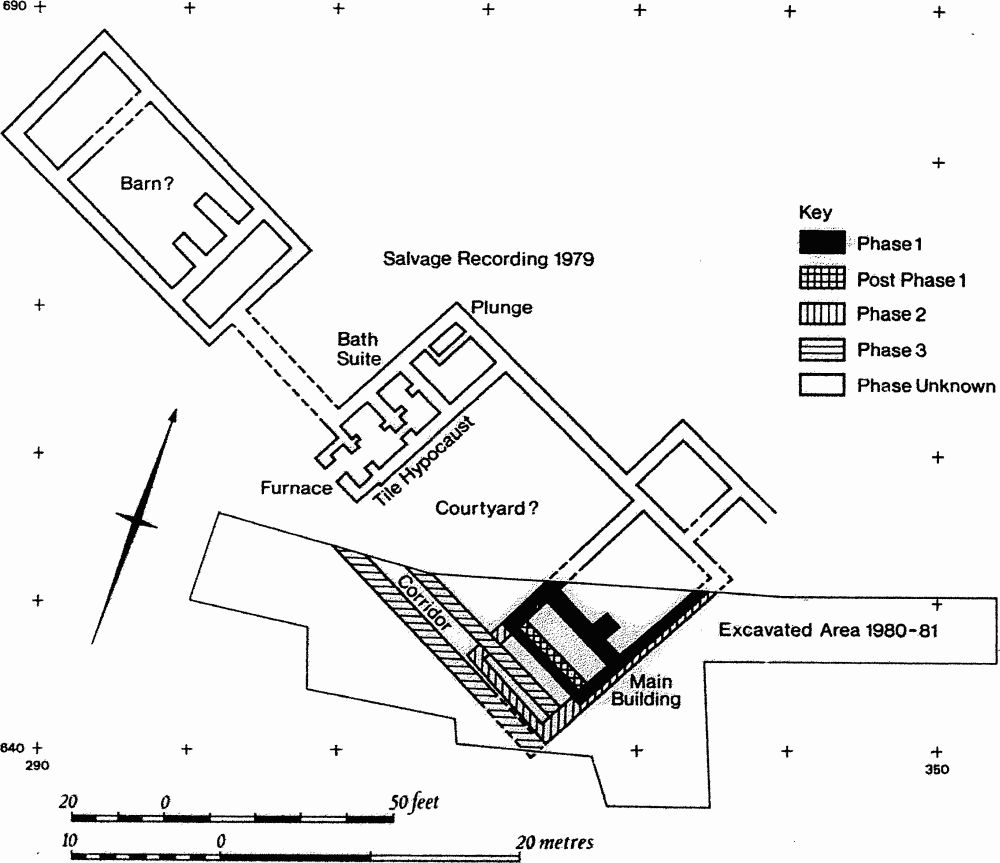
Fig. 38 Roman villa.
b(9) Roman Coin Hoard (c. SP 758562), S. of Wootton village, on Upper Lias Clay, at 73 m. above OD. A total of 684 coins was found in 1842 in a pot in a stone-pit. They ranged in date from Gallienus (AD 253–68) to Numerianus (AD 283–4). Skeletons and 'other remains' were found in the same pit (NM, Dryden Collection; Archaeol J 1 (1845), 67; VCH Northamptonshire I, 222; George 1904, 6, 21; Wetton 1849, 140; Whellan 1874, 284; NDC R60, 125).
Medieval and Later
A sherd of early to middle Saxon pottery was discovered during field-walking in 1980 (field centred on SP 73755800; NDC AS27) and eight further sherds were found during the excavation of the Roman villa at Hunsbury (Wootton (8)). Possible Saxon sherds were discovered in the parish in 1954 (NM; NDC AS25). An iron spearhead, probably Saxon or medieval, was found near Wootton West Bridge (SP 757560) in 1937 (NM; NDC R57). A 12th-century pottery bottle was discovered in Wootton village in 1957 (J Northampton Mus 3 (1968), 9, 11; NDC M17). Medieval pottery has been recovered within the village (SP 762564; NM; NDC M91) and more is recorded from N. of Wootton (SP 762568) together with 19th-century pottery and fragments of iron found during modern housing development (Northamptonshire Archaeol 9 (1974), 111; NDC M194.
The earthworks, said to include a motte and settlement remains, on the S. side of Berry Lane (SP 759562; Northamptonshire Archaeol 9 (1974), 111) are old quarry pits and modern disturbances to ridge-and-furrow.
(10) Parish Church of St. George (SP 761566; fiche Fig. 39; Plate 34)
Development
There is no visible part of the present fabric earlier than the 13th century but the irregular plan in which the tower and W. walls are now on a markedly different axis from the nave, suggest that they survive from an earlier structure. The chancel and nave belong to the 13th century, the aisles being added c. 1275. The roof line of the nave of this stage is preserved on the E. face of the tower. The aisles were refenestrated and extended to the E. as chapels in the late 14th century. In the 15th century the clearstorey was formed, the belfry stage of the tower added or rebuilt and the S.E. window in the chancel inserted, with the sedilia below. The church was repaired in 1844 and extensively restored in 1865 by William Butterfield. The chancel arch and the arches between the chancel and flanking chapels were rebuilt, the N. porch removed and a new S. porch built (Faculty NRO 374P/60/1). (VCH Northamptonshire IV, 294–5)
History
Since Wootton Church was claimed as part of the foundation endowment of Lavendon Abbey (Bucks) in a royal confirmation of 1227 (Mon Angl 6, 888) it appears that the building existed by 1155–8 (Knowles and Hadcock 1971, 190). However, since the abbey was not able to prove posession at law in 1231, doubt must be cast on the authenticity of the original grant. The heirs of the founder of Lavendon claimed that their father had held the advowson of the church subsequent to the date of the foundation charter and that the abbey's claim to possession was invalid (Maitland 1887, no. 648). They won their case and subsequently presented Walter de Horton to the rectory in 1232 (Rot Welles II, 168). The advowson remained in lay hands throughout the medieval period.
The heirs also said in 1231 that the last two incumbents of Wootton had both been named Walter de Bidun. The first Walter de Bidun, also Chancellor of Scotland, died in 1178 (Powicke and Fryde 1961, 173). This indicates that was certainly a church at Wootton by 1178.
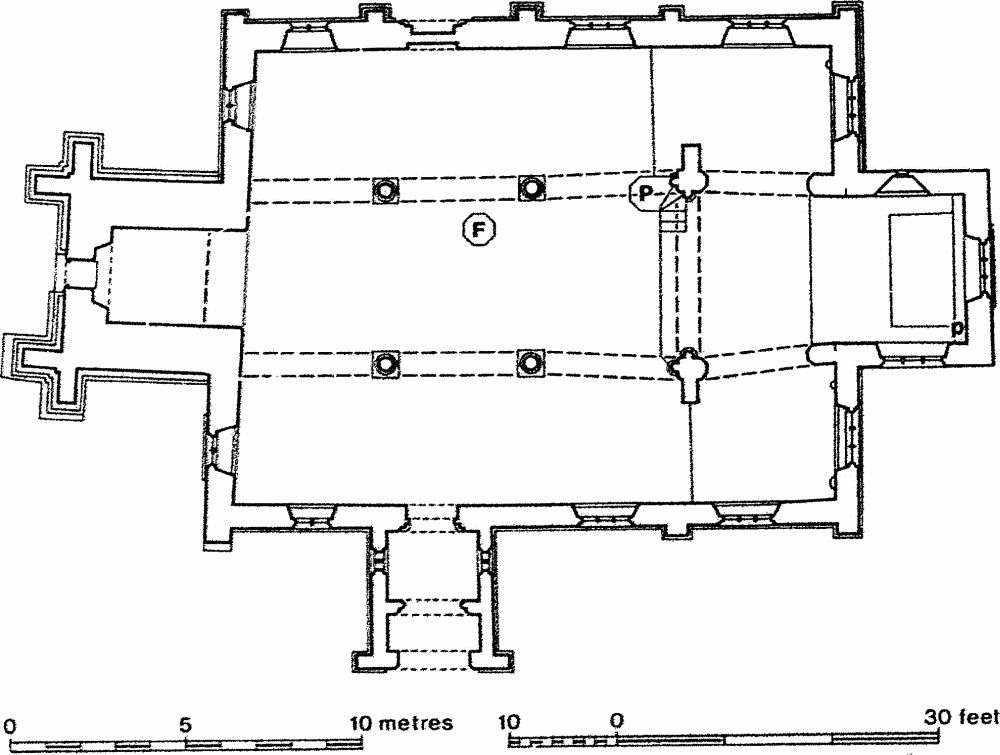
Fig. 39 Parish Church of St. George.
Description
The church consists of a Chancel, Nave, North and South Aisles, which run forward to embrace the chancel, South Porch and a West Tower.
Chancel
The two-centred arch to the N. aisle was rebuilt in 1865; it has one broad chamfer, interrupted by a simple impost moulding. At the E. end of the N. wall is a lancet window. The three-light E. window has tracery of a foil cusped into three major trefoils and three minor (cf. the E. window of Collingtree church). The tracery is 19th-century but may reflect the original (Clarke). At the E. end of the S. wall is a trefoil-headed piscina and two sedilia with cinquefoil heads. Above is a three-light window with panel tracery. The arch to the S. aisle is similar to that on the N. The arched brace roof is perhaps of late medieval origin but was elaborately painted in the 19th century.
Nave
The arches of the three bay N. arcade are double chamfered, the inner chamfer being hollow. There is one head stop to the label on each side, set over the E. pier. The W. respond is a foliate boss. The piers consist of round shafts and moulded capitals, the shafts raised on bases 20c mm. high. The E. respond has a polygonal half-shaft with a moulded capital, perhaps of the 19th century. There are three clearstorey windows, each with two cinquefoil-headed lights. The chancel arch, rebuilt in 1865, is double-chamfered, the outer continuous, the inner carried on polygonal half-shafts. The N. and S. walls and E. gable are battlemented, the E. gable carrying a Sanctus bell-cote. The battlements at the angles and in the centre of the walls are decorated with blind trefoil panels. The S. arcade and clearstorey repeat those on the N. The tower arch is of two chamfered orders, the inner carried on grotesque head corbels. Above the arch is an internal opening with a two-centred head. The crease of a steep-pitched roof is visible above the present tie-beam roof which is perhaps 18th-century.
North Aisle
The exterior of the N. aisle has a continuous string course at sill level. The westernmost window in the N. wall is straight-headed and has two cinquefoil-headed lights with pierced spandrels. To the E. is a blocked two-centred doorway of two orders, the outer moulded and carried on shafts with moulded capitals. Above the doorway is a trefoil-headed niche, also with shafts and moulded capitals. The other two windows in the N. wall and the E. window are similar in detailing to the N.W. window but are of three lights. There is a worn bracket to the N. of the E. window. The W. window of the N. aisle is straight-headed and of two lights but the lights are trefoil-headed. The roof is 17th or 18th-century.
South Aisle
The straight-headed, three-light E. window, similar in detailing to the windows in the N. wall, has stone brackets to N. and S., that on the S. carried on a corbel with a king's head. The windows in the S. and W. walls are the same as the corresponding ones of the N. aisle. The S. doorway has a moulded two-centred arch of two orders, similar to the N. The S. aisle roof is 17th or 18th-century. The S. porch is 19th-century, replacing one of the 17th or 18th century (Clarke). It has an unusual two-cell plan.
Tower
The tower rises in two stages with angle buttresses but without set-backs. The plinth moulding is confined to the tower alone. The W. window is of two lights with tracery of a quatrefoil, of 1865, like the doorway. On each face, just below the belfry, is a single-light window with two-centred head; that on the E. must always have looked into the nave, as now. The belfry openings are of two lights with tracery of a quatrefoil; that on the S. formerly consisted of twin lancets. The parapet has battlements and angle pinnacles, much worn.
(11) Cultivation Remains. The common fields of Wootton were enclosed by an Act of Parliament of 1778. Three open fields, Preston Hedge, Long and Blackemoor or West Fields are recorded in a series of Glebe Terriers dating from 1627–1777 (NRO). Ridge-and-furrow of these fields exists on the ground or can be traced on air photographs over much of the parish, indicating that all but the very wettest ground along the Wootton Brook and the R. Nene was under cultivation at some time in the medieval or post-medieval period. Most of the surviving ridge-and-furrow lies in the centre and the E. of the parish. In the E. it is arranged mainly in interlocked furlongs, but on the steeper ground to the W. of the village it is usually in end-on furlongs running across the contours. Further details of the ridge-and-furrow in the parish have already been published (Hall 1976; RAF VAP, V58–RAF-1122, 0329–36, 0367–78; CPE/UK/1994, 1179–84, 2179–82, 3171–6; FSL 6565, 1846–50).