A History of the County of Wiltshire: Volume 8, Warminster, Westbury and Whorwellsdown Hundreds. Originally published by Victoria County History, London, 1965.
This free content was digitised by double rekeying. All rights reserved.
'Warminster: Introduction', in A History of the County of Wiltshire: Volume 8, Warminster, Westbury and Whorwellsdown Hundreds, (London, 1965) pp. 90-96. British History Online https://www.british-history.ac.uk/vch/wilts/vol8/pp90-96 [accessed 25 April 2024]
WARMINSTER
Warminster 1962
Warminster (fn. 1) lies at the foot of the downs, near the north-west corner of Salisbury Plain, which ends here in the conspicuous Arn Hill (694 ft.). (fn. 2) From Arn Hill a ridge of land about 400 ft. high joins the Plain to the isolated height of Cley Hill to the west, and forms the watershed between the valley of the Biss and Frome to the north and that of the Wylye to the south. Warminster grew up at the confluence of two small streams which rise in the southern slope of the ridge; after their junction they form the Were which gave the town its name. (fn. 3) The stream, called the Swan River since at least the mid-19th century, (fn. 4) is still only small as it flows on to join the Wylye, which skirts the parish on the south. To the west of the town begins rather higher and more broken country, formerly heathland but now largely wooded, which forms the eastern verge of the Longleat estate.
The ancient parish of Warminster differed considerably in its boundaries from the present urban district. (fn. 5) From the 1962 boundary between Tascroft Farm and Botany Farm a narrow strip extended westward to the Somerset border near Stalls Farm, so that the parish was over seven miles long. South-east of Bishopstrow the former common meadow of Pit Mead was manorially part of Warminster, but was parochially divided between the parishes of Warminster, Bishopstrow, and Norton Bavant. Adjoining it the former farm at Moot Hill belonged to Warminster; smaller detached pieces included Eastleigh Farm and some land near Norridge. Inside the Warminster boundary lay small detached pieces of Corsley, Upton Scudamore, and Boyton. By the Divided Parishes Act of 1882 (fn. 6) and an order of 1883, (fn. 7) Pit Mead and Moot Hill Farm were assigned to Sutton Veny and Eastleigh Farm to Bishopstrow, and the smaller detached pieces were included in the parishes which surrounded them. In addition, detached parts of Bishopstrow and Norton Bavant, which adjoined Warminster on the south, were included within it; together they stretched from Botany Farm to Henford's Marsh. These changes made the area of the parish 6, 564 a. (fn. 8) In 1934 the western part of the parish, from Tascroft Farm to the Somerset border, was added to Corsley, leaving the urban district with an area of 5,658 a. (fn. 9)
Within its boundaries Warminster parish included a diversified stretch of country. The high chalk downland of Salisbury Plain, which provided good sheep pasture, is penetrated by deep combes at Mancombe and Oxendean. On either side of them ridges of high land reach to the south, culminating in Arn Hill to the west and Battlesbury to the east. They enclose a lower area of greensand, separated from the Wylye valley to the south by the chalk outliers of Cop Heap and Chalk Hill. This greensand, and a similar area west of Arn Hill to the north of the town, provided most of Warminster's open field arable land before the parish was inclosed in the late 18th century. The town itself lies roughly in the centre of the parish, on well-watered land protected from the north by the downs, providing good meadow and garden land. More meadow and pasture lay along the Wylye and to the west of the town. Most of the south-western extremity of the parish was open common until the inclosure; it has since been planted with woods and forms the outlying part of Longleat Park. Of the hamlets outside Warminster, Smallbrook was mentioned separately in 1086 and still in the 14th century, (fn. 10) but has long been reduced to a single farm. Bugley and Boreham remain semi-rural, connected to the town only by sporadic ribbon-development. The origin of the large hamlet of Warminster Common is discussed below. (fn. 11)
Apart from prehistoric occupation, of which considerable evidence has been found in the hillfort of Battlesbury, the earliest known inhabited site in Warminster is that of two Roman villas found in the late 18th century at Pit Mead, while deposits of Roman coins have been found at the Common, and Romano-British remains at Arn Hill and Mancombe Down. (fn. 12) No Roman road ran this way, but the site of the town lay on a viable route from Salisbury to Bath; there the traveller could descend from the downs and perhaps spend a night before going on to meet the road south from Bath near Beckington. (fn. 13) Warminster seems to have owed its comparative inportance in Saxon times rather to its being a royal manor than to its position on a north-south route. Its status as a borough may be inferred from the late 10th century, when moneyers, who were limited to boroughs by law, worked there, (fn. 14) while the minster which gave the town its name must have supplied the spiritual needs of a considerable district around it in even earlier times. (fn. 15) It was a royal residence in the early 10th century, (fn. 16) and at the Conquest its obligation to provide the farm of one night was probably of ancient standing. There is no evidence, however, that its importance arose from its urban character. There were, it is true, 30 burgesses in 1086, but they lived on the royal demesne, and were probably only the traders and craftsmen who served the needs of the large estate which surrounded them. There is no indication of heterogeneous tenure or the payment of the third penny, two of the hallmarks of the urban Domesday borough. (fn. 17) No moneyers are known to have worked in Warminster after the reign of Harold I, (fn. 18) and the town never developed any organ of self-government or achieved parliamentary representation. (fn. 19)
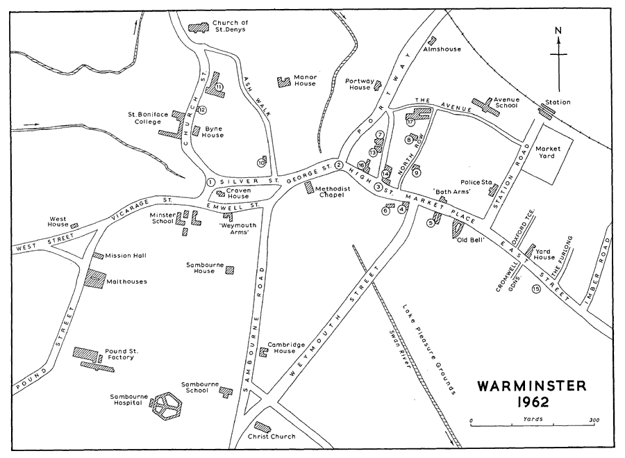
The development of Warminster into a relatively prosperous town, which with its 304 poll-tax payers in 1377 stood tenth in the county, (fn. 20) was based on its market, first mentioned in the 13th century. (fn. 21) In the 12th century the capital manor was granted away from the royal estate, (fn. 22) and there are slight indications of growth in the town which may have taken place under the new lords, and may even have been artifically fostered by them. They are to be deduced from the plan of the town. The parish church stands at the very end of the town, and nearby is the site of the manor house. They stand on a slight rise, almost surrounded by two small streams, which no doubt marks the area of the earliest settlement. From the church a curved street leads southwards to an open space at the junction of other roads leading east and west; here until the 18th century stood the remains of a cross called the High Cross or Emwell Cross. (fn. 23) In the early 19th century the tradition still remained in Warminster that this place had once been the centre of the town, which had extended no further east than Almshouse Bridge (now the junction of George Street and High Street). (fn. 24) The present centre of the town, the wide and straight High Street and Market Place, extends on the opposite side of the bridge. This was called the market of Warminster in the earlier 13th century, when a shop covered with stone stood there adjoining the Chapel of St. Laurence. (fn. 25) Other permanent buildings there were mentioned later in the century. (fn. 26) Such a street or market-place, distinct though not necessarily separate from an older settlement, is a feature of the artificially-fostered new towns of the 13th century. (fn. 27) It may be that in Warminster development was less formal than the founding of a new town attached to the rural manor, but the occurrence of the place-name Newport applied to at least part of this end of the town in the 14th century (fn. 28) must add some weight to the supposition that the town grew eastwards in the 13th century.
Little else is known of Warminster's development in the Middle Ages. Houses in Byne Street, the modern Church Street, are regularly mentioned from the 13th century. (fn. 29) West Street was sonamed by 1325, (fn. 30) and houses lay in Newport Street, now Portway, by 1366. (fn. 31) The whereabouts of 'Curtstrate' of the 13th century, (fn. 32) and 'Pidemanneslane' of 1384 (fn. 33) is not known. Nor are there visible remains of building to fill in the picture of the medieval town. It seems reasonable to assume, however, that at the end of the Middle Ages Warminster stretched from the church to the east end of the Market Place; the part west of Almshouse Bridge was probably not very closely built, for even in the 18th century some lessening of density and greater informality in the layout of the houses and plots could be detected there. (fn. 34)
By the 16th century the fame of Warminster market was well-established, and the clothing and malting trades, which with the market were to be the economic mainstays of the town until the 19th century, had begun. (fn. 35) Some expansion may have resulted from the growth of these industries. A house with a timber-framed upper story (now no. 34 Vicarage Street) standing in the former West Street, past its junction with Pound Street, shows its extent to the west, and the mention of a house adjoining the Common Close in 1572 (fn. 36) probably indicates growth to the north too. Other timber-framed houses perhaps of this period survive in Silver Street (nos. 39, 44-50) and High Street (nos. 36-37), though all have been variously refronted. The central block of the house in Emwell Street, now the 'Weymouth Arms', contains a 16th century-fireplace. All but the most important houses in the town were probably of timber at this time; in 1638 13 out of 14 houses in the town belonging to the manor of Furnax were of timber, thatched with straw or reed. (fn. 37) The most substantial buildings in the town were perhaps the inns, with which the town was well supplied for the convenience of visitors to the market. In 1686 Warminster stood fourth for accommodation among Wiltshire towns, with 116 beds and stabling for 328 horses, (fn. 38) and it was said that there were 51 inns and alehouses in the town in 1710. (fn. 39) The value of the principal ones may be judged from the price of £1,000 paid for the 'Red Lion' in 1636. (fn. 40) The best example of the old inns of the town is the 'Old Bell'; its exterior of coursed rubble stone probably dates from the late 18th century, but the interior has earlier timber work which may connect it with the 'Bell' of 1483. (fn. 41) The open arcade across the pavement, said to have been for the protection of buyers and sellers at the market, was formerly a feature of other Warminster inns, including the 'Anchor' (fn. 42) and the 'Red Lion'. (fn. 43)
Warminster was the scene of some activity in the Civil War. Henry Wansey, a Warminster man, was a major in the Parliamentary forces; in 1644 when he was besieged at Woodhouse in Horningsham, another force under Edmund Ludlow was prevented from relieving him after a skirmish on Warminster Common. (fn. 44) The town also contained other parliamentary sympathizers; (fn. 45) in 1646 it was said that it had suffered to the extent of £500 by being a parliamentary garrison. (fn. 46)
It is in the 17th century that we first know anything of the external road connexions of Warminster. The only road through the town mentioned in Ogilby was a now lost way over the Plain from Amesbury through Shrewton, which descended into the Wylye valley near Norton Bavant and, passing through Warminster, went on to Maiden Bradley. This was the main road from London to Barnstaple in 1675, (fn. 47) and in 1754 it was still as a place on the road from London to the west that Warminster was noted. (fn. 48) There were routes from Salisbury to Bath which avoided Warminster altogether, and even if the traveller kept roughly to the line of the present main road between the two places, he did not actually pass through the town. From Thoulstone the road skirted Upton Scudamore village, joined the road from Westbury, and passed east of Warminster by Cop Heap Lane and Woodcock to join the road down to the Wylye valley beyond the present Bishopstrow House. (fn. 49) The present main road from Thoulstone to Warminster church, which brought the route through the centre of the town, was turnpiked in 1752. (fn. 50)
The 18th century was a prosperous time in Warminster; the malting and woollen trades and the market all flourished, and in 1751 it was described as a 'Populous place with good inns'. (fn. 51) The population grew somewhat. In 1665 there were 354 householders in the town, (fn. 52) which indicates a total of perhaps 1,800 people. In 1781 the town within the turnpike gates contained 539 houses and 2,605 inhabitants. (fn. 53) In extent it probably grew most towards the west. By 1783 houses stretched along West Street on both sides for ½ mile beyond the High Cross and along Pound Street further than the end of Princecroft Lane. (fn. 54) Houses in Pound Street are mentioned by 1748, (fn. 55) and some at Topps, near Princecroft Lane, rather earlier. (fn. 56) In 1783 cottages, some evidently built on waste at the side of the road, extended sporadically along Portway as far as the bottom of Elm Hill. (fn. 57) East of the town houses extended as far as the Imber road, and some of the cottages of the Furlong were built. The row of houses built on the grounds of the prebendal mansion house (from the 'Masons' Arms' to East End Garage) was at least partly built by 1751, when the Packhorse Inn stood in it. (fn. 58) East of the Imber road a number of houses stood in the Boreham road on plots probably made available by the inclosure of open-field land. Houses bearing the dates 1712, 1718, and 1739 still stood there in 1962. (fn. 59) In the older area of the town courts began to develop on what had been the gardens of houses. Meeting House Lane, now North Row, probably dates from the establishment of the Old Meeting there in the late 17th century. (fn. 60) Other surviving courts are Three Horseshoes Yard, off the Market Place, and Oxford Terrace and Cromwell Gardens (formerly Ludlow's Court), off East Street.
The period has left ample evidence of its prosperity in buildings, and the amount which remains will allow only general observations to be made. The most common building material was a roughlysquared rubble stone, apparently quarried locally, (fn. 61) and laid in courses of about the depth of brickwork. It was used in buildings ranging in size from cottages to all but the largest houses, and in 1796 Arthur Young described Warminster as a stone town. (fn. 62) Many groups of cottages built of this rubble can be seen in West Street and Pound Street; good examples of its use in larger buildings are West House (no. 12 West Street) and Lord Weymouth's Grammar School of 1707 in Church Street. The latter is of two stories and attics, with mullioned and transomed windows, and has an elaborate central doorcase which came from Longleat, and was designed by Wren. (fn. 63) In larger rubble houses ashlar was used for quoins and window surrounds; it was used with great effect to embellish no. 32 Vicarage Street. Only the most pretentious houses such as Portway House and the Manor House, both described below, (fn. 64) were entirely faced with ashlar. Brick does not appear to have been in general use, but was evidently highly thought of from the mid-18th century. The earliest surviving example is probably in the wings of the house in Emwell Street, used since 1928 as the 'Weymouth Arms', (fn. 65) where its use may date from 1749; Craven House in Silver Street, dated 1774, where it is used for the front only, and nos. 3-4 Church Street are prosperous brick houses of the second half of the century. In cottages it was used extensively for quoins and window surrounds. Tiles were the most common roofing material, although much thatch survived on smaller buildings until the 19th century. (fn. 66) Large and prosperous houses are to be found in all parts of the town, but there is a striking group in Church Street. Byne House, built by John Wansey in 1755, (fn. 67) has three-light windows with the central light taller than the outer ones, similar to those in the Chantry, High Street, and the house, dated 1767, now converted into the Regency Arcade in East Street. These houses are also notable for their Venetian windows, of which there is another good example at no. 25A High Street. They were probably by a local architect, unlike the house in Church Street, which William Wansey had built by Joseph Glascodine, a Bristol man, in 1796; (fn. 68) this must be the house now incorporated in St. Boniface's College, which bears that date. Elaborate doorways can be seen at nos. 3 and 4 Church Street. The buildings of three of the chief 18th-century inns of the town survive. The 'Angel', now no. 4 High Street, and the 'Lamb', no. 51 Market Place, are both three-storied houses of rubble, used as shops. The building which still houses the 'Bath Arms' must date, externally at least, from 1732 when the 'Three Goats' Heads', which stood on the site, was let on condition that it was rebuilt. The new house was first called the 'King's Arms', but the name 'Lord's Arms' or 'Weymouth Arms' was used by 1769. (fn. 69)
The deliberate improvement of Warminster streets probably began soon after the first Turnpike Act affecting the town was passed in 1727. It affected seven roads radiating from Warminster; none was over three miles long and some did not leave the parish, so that the purpose of the Act was clearly local improvement rather than the care of a long stretch of a nationally important route. The roads in the town were described in the Act as 'ruinous' and 'impassible in winter', (fn. 70) and although the phrases were conventional, it is clear that they were also accurate. Water ran over the road through the town at four places, Coldharbour, High Cross, Chain Street, and Almshouse Bridge. Chain Street itself was closed to all except foot passengers by chains at either end, and the horse road ran behind the houses along 'shallow water, or the backside of Chain Street', which was often flooded in winter. (fn. 71) The way in East Street was so deep that it was possible to jump from the footpath on to the top of a loaded hay-waggon. (fn. 72) The earliest improvements of which we know were carried out in 1759, when Portway, which had previously been only a bridle track, was made into a road by the demolition of a number of cottages. (fn. 73) In 1765 Thomas Marsh, a timber-merchant, took a lease of all the ground on the west side of Portway from Almshouse Bridge to Portway House, and built several houses on it. (fn. 74) The hollow way in Pound Street was filled up in 1759, and a new road, probably the present Sambourne Road, was made to the Common, replacing a deep and winding lane. (fn. 75) In 1763 a road bridge was made at Almshouse Bridge to replace the narrow wooden footbridge, and the stream at Coldharbour was bridged in 1770. (fn. 76) In 1769 the base of the High Cross, and a barn which stood in the street near it, were removed to improve the junction of Church Street and West Street; the obelisk, which commemorates the inclosure of the parish, was placed on the site of the cross in 1783. (fn. 77) In 1792 the turnpike commissioners obtained additional powers to make and maintain pavements in the town. (fn. 78) Such improvements no doubt encouraged improvement in buildings, and several substantial houses in the Market Place date from about the end of the century. The terrace which extends east from the 'Old Bell' was built after 1783 to replace several scattered houses, parts of which may still be seen at the rear. On the same side of the road no. 14 is of about 1800, built on the site of the Bush Inn.
In the first half of the 19th century Warminster's clothing trade collapsed, and malting declined somewhat, though it still remained important. The market suffered for a time from the competition of other towns with better communications. In spite of this the town seems to have suffered no permanent depression. Increase in retail trade, and new occupations such as brewing and iron-founding had, it was considered in 1860, made up for the loss of the clothing trade, while the silk mill at Crockerton provided employment for many women and girls. (fn. 79) This is borne out by population figures. From 4,932 in 1801 the number declined slightly by 1811, when the slump in the cloth trade was severe, but rose to 6,115 by 1831, and slightly more, to 6,285 by 1851. (fn. 80) Cobbett approved of Warminster as a 'solid and good town', with 'no villainous gingerbread houses running up', (fn. 81) and in 1830 it was said that a spirit of improvement was very apparent. (fn. 82) This spirit has left a permanent mark on the town. The first movement of the century was initiated by the bequest of George Wansey, who in 1807 left £1,000 to be laid out in improvements provided that another £1,000 was raised for the same purpose. A committee was formed which bought all the houses on the south side of Chain Street and demolished them, so making the wide road called George Street, presumably after the donor. (fn. 83) On the north side land which had previously been gardens was let for building, and a row of three-storied brick houses of uniform design was built on it c. 1815. (fn. 84) Further east a fire which destroyed a number of houses at the corner of Portway and High Street gave an opportunity for rebuilding, and the plain three-storied houses which stand there are of c. 1825. (fn. 85) On the opposite corner the two-storied houses nos. 36-40 George Street are of c. 1831, (fn. 86) and the widening of the road here, completely covering the stream so that all semblance of a bridge disappeared, was carried out in 1832. (fn. 87)
There were also notable changes in the Market Place. In 1830 Weymouth Street was made from it to provide a new road to Sambourne. Its cutting provided an opportunity to build a new Town Hall and demolish the old one which stood inconveniently in the middle of the Market Place. (fn. 88) Edward Blore, the architect of the new building, also designed the group built in the Tudor style, an early example of its use, at the opposite corner of the new road, (fn. 89) on the site of an inn called the 'King's Arms'. (fn. 90) The corner building, which housed the newly formed Literary and Scientific Institute, was opened in 1838. (fn. 91) Other buildings were improved by their occupiers. No. 3 High Street, which had been built c. 1730, was improved in 1841 at a cost of over £700, and its plain front of ashlar must date from then. (fn. 92) Some new buildings were also put up, such as those at the east corner of North Row and the Market Place, built in 1831, (fn. 93) and the terrace of early-19th-century houses, now nos. 52 and 53 Market Place.
While the centre of the town was being transformed, the movement of the wealthier inhabitants to the outskirts which was typical of the period went only slowly. The earliest suburban house in Warminster was probably Sambourne House, built by Henry Wansey c. 1800. (fn. 94) Cambridge House, also in Sambourne Road (nos. 54-55), must be of about the same time. Several smaller houses dating from the earlier part of the century may be seen along the Boreham road, such as no. 89 East Street, a stone-built villa, and nos. 35-37 Boreham Road, a pair of brick houses. Boreham Terrace is of six brick houses of three stories (nos. 24-34 Boreham Road); all these were probably among the 'elegant and lofty houses' which had been very recently built in 1822. (fn. 95) By 1840 a group of cottages and four larger houses (nos. 81-87) had been built further along the road near what was to be the site of St. John's Church, and at Boreham itself two large villas, Heronslade and Boreham Villa. (fn. 96) Other parts of the town were less favoured. Even after Christ Church was built at Sambourne in 1830, New Road and Sambourne Road did not prove attractive to builders; perhaps they were too near the Common and the Union Workhouse, built in 1836, or perhaps freehold land was not available. The west end of the town, West Street and Pound Street, was a predominantly working-class area which did not expand at this time.
The railway from Westbury to Warminster was opened in 1851, and extended down the Wylye to Salisbury in 1856. (fn. 97) Its coming marked the beginning, and was largely the cause, of a period of comparative depression. The great market declined almost to nothing, the retail trade suffered in consequence, and hardly any industry was carried on. Even in 1860, before the full effects had been felt, Warminster was 'a clean-swept, semi-aristocratic, decidedly poor place', in a 'lukewarm, stagnant, bankrupt state'. (fn. 98) By 1871 many inns had been closed, and carriers and others connected with the market had left the town. (fn. 99) In the 1890's shopkeepers did not get one busy day a month, and a traveller was told that the town had 'gone to sleep and never wakes up' so that 'men rust out rather than wear out'. (fn. 100) The population declined slightly at each census until it was 5,547 in 1901, a decrease of over 700 since 1851. (fn. 101) Building in the town was discouraged by its declining state and by the policy of not renewing long leases pursued by the Longleat estate. (fn. 102) Several public buildings were, however, built in the 1850's. The Savings Bank at the east end of the Market Place is of 1852. The name of its site, Hatchet Corner, is derived from an inn which stood there from the 16th century until c. 1789. (fn. 103) The Corn Market, opened in 1855, was built on the site of the 'Red Lion' which had been burnt down four years earlier, (fn. 104) and the Athenaeum, designed by the local architect, W. J. Stent, in an early Renaissance style, replaced the London Inn in 1858. (fn. 105) The improvement made in 1856 by exposing St. Laurence's Chapel to the street has been mentioned below. (fn. 106) There are few buildings of the later part of the century in the centre of the town; among them are those occupied in 1962 by Lloyds and Barclays Banks and nos. 36 and 40 Market Place and 11 High Street. An important improvement carried out c. 1900 was the opening of Common Close into the High Street by the removal of the 'Ship'. (fn. 107)
New building was desultory in the suburbs of the town. The Boreham road continued to be the most favoured site for villas; its attraction was increased by the building of St. John's Church in 1865. Boreham Villas, three pairs of stone houses, now nos. 52-62, date from before 1860, (fn. 108) and another pair, nos. 35-37, were built by 1874. (fn. 109) St. John's Lodge, built in 1883, (fn. 110) and Highbury, of about the same time, are large detached houses. North of the town nos. 67-68 Portway are perhaps the new pair of villas built there in 1863, (fn. 111) and Downside and Portway Villa are of much the same time. (fn. 112) A few houses were also built near Christ Church by 1886, including Christ Church Terrace and Hampton House. (fn. 113) In the 1890's a future direction of suburban expansion was indicated by the building of a number of houses on the Imber road north of the railway. (fn. 114)
The early years of the 20th century saw little change in Warminster. Combination in the brewing industry led to the closing of the small breweries which had grown out of the older malting businesses, and what little manufacturing industry there was in the town employed few hands. There was a tendency to regard the town's future chiefly as residential. It had a pleasant position and many well-built large houses. During the incumbency (1859-97) of Sir James Philipps it had become a centre of Anglican activity. (fn. 115) Sporting facilities included good fishing and hunting country and a golf course opened in 1891. (fn. 116) In 1907 a Town Advertisement Committee was formed. It authorized the production of a town guide, and inserted advertisements in the G.W.R. publication Holiday Haunts. An ambitious project to build a hotel and villas in Elm Hill and Cop Heap Lane only broke down because the committee insisted on refusing the plots offered by Lord Bath, and asked for others more favourably placed. (fn. 117) The population of the town declined slightly in each decade between 1851 and 1931, (fn. 118) so that it was little bigger in 1931 than in 1801. It was the approach of the Second Word War which finally halted the economic decline. Camps and permanent barracks in the town were begun in 1937, (fn. 119) and a large workshop for vehicle repairs was opened in 1940. (fn. 120) After the war Warminster remained a permanent garrison town, housing the School of Infantry and a R.E.M.E. workshop. Large estates of married quarters were built. Several light industries were also begun, and the population of the town in 1961 was estimated at 9,900.
The growth of a settlement of houses built on the waste at the edge of Warminster Common can be traced from the late 17th century. A cottage which adjoined other cottages there belonged to the Longleat estate in 1668, (fn. 121) and by 1727 a parish workhouse was built there. (fn. 122) In 1739 it was complained that one cottage, built 20 years before, had since been enlarged to hold four families, and an attempt was made to prosecute the inhabitants for not having the statutory four acres adjoining their dwellings. (fn. 123) About 1770 an attempt to establish the lord of the manor's ownership of the cottages ended in failure. (fn. 124) By 1781 there were 200 houses in which lived 1,015 people. (fn. 125) The squalor of the place in the late 18th century was vividly described by William Daniell. Hovels of one room up and one down, unceiled, unplastered, and with earth floors housed families which were without the commonest necessities of life. Outside piles of filth corrupted the stream which was the only water supply, so that typhus was rarely absent and smallpox not uncommon. The rudeness of the Commoners matched that of their houses; respectable people would not go there, and Sundays were occupied in brutal sports, fighting, and drunkenness. The ill-fame of the place for crime was known as far away as Devon. (fn. 126) The labours of Daniell himself, and of the Anglican clergy, to reform the inhabitants are mentioned below. (fn. 127) They were accompanied by a gradual physical improvement, and by 1833 the hamlet was neat, clean, and respectable. (fn. 128) The seal was set on its respectability in the following year, when the streets were named by a committee of the vestry. (fn. 129) By 1862 even the name of the Common had begun to be abandoned in favour of New Town. (fn. 130) Many of the rubble cottages which still stand there in 1962 date from the early 19th century. A survivor of an earlier time is the thatched house at the corner of Broadway Road.