A History of the County of Wiltshire: Volume 17, Calne. Originally published by Victoria County History, London, 2002.
This free content was digitised by double rekeying. All rights reserved.
'Calne: The town in the 19th century', in A History of the County of Wiltshire: Volume 17, Calne, (London, 2002) pp. 41-44. British History Online https://www.british-history.ac.uk/vch/wilts/vol17/pp41-44 [accessed 18 April 2024]
The town in the 19th century
In 1801-2 the Wilts. & Berks. canal was extended to the Town mill at the east end of Cox's Hill from a basin 200 m. south of the mill. The extension was achieved by canalizing the Marden. A wharf was built on the west side of that stretch of the canal and, 120 m. south of the mill, a building was erected incorporating a wharfinger's house and what was probably warehousing. (fn. 1) Unusually for Calne, the house is of sandstone; its front range has a threebayed ashlar façade with a fluted frieze similar to that of Castle House. The building was in use as a community centre in 1999. About 1806 a new mill was built near the existing mill, which was demolished. (fn. 2)
When the wharf was built the bridge over the Marden linking Patford Street and Patford Lane was replaced by a new bridge, on the same site or nearby, near the wharfinger's house, and in 1801 a new road was built along the east bank of the canalized river to link Patford Lane to Port bridge at the north-west end of Butcher Row. Patford Lane was widened and the name New Road was given to the whole stretch of road from the south-west corner of the Green to Port bridge. (fn. 3) In 1801 Butcher Row, until then probably the main course of the London road through the town, was considered too narrow for the traffic using it, (fn. 4) the new bridge over the canalized Marden near the wharfinger's house, although it linked New Road and the wharf, did not link New Road and Patford Street, and from 1801 London- Bristol and London-Bath traffic bypassed Back Street, Church Street, Butcher Row, and Patford Street by using New Road. (fn. 5) About 1801 Port bridge was rebuilt as a longer and wider bridge to make it easier to use from New Road. (fn. 6) In 1863 a road was built to link New Road to the railway station then opened southwest of the wharf. (fn. 7)
Between Port bridge and the Town mill there was a pool in the Marden to serve the mill, (fn. 8) and from the 17th century or earlier the adjoining land was called the Strand. (fn. 9) From c. 1801 the Marden fed the mill and the canal through a long and narrow pond across the Strand, where there was a place for horses to be washed and watered. The water was confined to vaulted culverts between 1840 and 1843, and the Strand, which from about then was used as a market place, became a town square. (fn. 10)
Calne seems to have flourished in the 19th century and, although the built-up area was little extended, (fn. 11) there was much new building, public and institutional, industrial and commercial, and domestic. The predominant building material was local limestone, mostly laid in regular courses and sometimes used as ashlar for dressings. Brick was widely used from the mid 19th century, but stone remained the preferred material for facing and few buildings were entirely of brick.
The market house, the first floor of which was converted to a town hall between 1826 and 1829, was demolished in 1882, Town mill was demolished in 1884, (fn. 12) and a new town hall, (fn. 13) completed in 1886, was built on the site of the mill. The new town hall was designed by Bryan Oliver, who won a limited competition in 1883. It is in Franco-Flemish late Gothic style and consists of two parts linked by a gatearch. The east part, a buttressed block adjoining New Road, contains the hall and, on its north front, has a clock tower facing the Strand. The west part, which may have been built shortly after the east, was a police station. (fn. 14) Between 1811 and 1877 three more nonconformist chapels were built, in Back Road, Pippin Road, and Silver Street, and others were rebuilt, and in 1867-8 a free church was built on the north side of the old Butcher Row. (fn. 15) On the west side of the Green two schools were built, and Bentley's school was rebuilt, in the earlier 19th century, and on the south side a technical school with large upper windows was built in 1894. A school was built in Mill Street in 1835, and in the mid 19th century schools were built in the angle of Wood Street and Curzon Street and behind the free church in the old Butcher Row. (fn. 16) A plain, late classical, ashlar-faced building erected in Church Street (now no. 13) in or shortly after 1840 was intended to be the premises of the Calne Society for the Cultivation of Useful Knowledge and was in use as a Mechanics' Institution in 1848, when it was bought by Calne Savings Bank. It was used by the bank until 1893, housed the reading room and library of the society, later Calne Literary Institution, from 1852 to 1905, and was an Oddfellows' hall from 1893. (fn. 17) At the north end, and on the west side, of the old Back Street a Constitutional club was erected in the late 19th century; (fn. 18) it is a large building in Queen Anne style with shell doorhoods. On the north-west edge of the town the union workhouse was built c. 1847, (fn. 19) a cemetery with a mortuary chapel was opened in 1867, (fn. 20) and a hospital was built in 1888. (fn. 21) The workhouse, designed by Thomas Allom and in Jacobean revival style, had a main three-storeyed block and two-storeyed flanking wings. (fn. 22) On the east edge of the town a recreation ground with a cycle track was laid out, and a caretaker's lodge and a pavilion were built, in 1890-1. (fn. 23) The lodge is a symmetrical three-bayed house in northern French halftimbered style; the pavilion has timber-clad walls and a steeply hipped roof on cast-iron brackets.
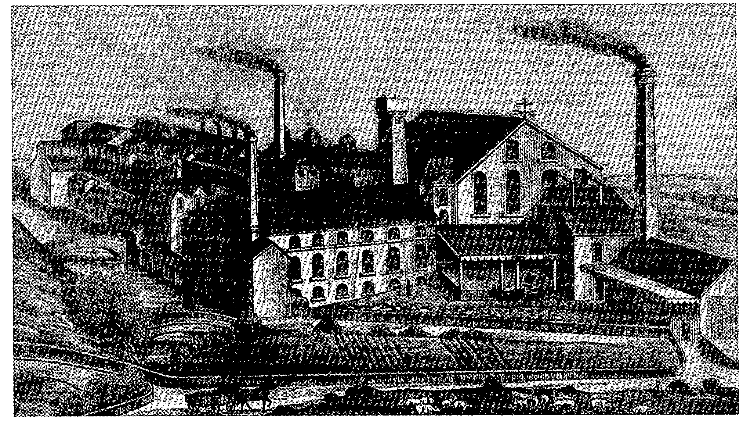
Thomas Harris's bacon factory, behind High Street, in 1887
In the early 19th century there were apparently many buildings in which cloth was made, besides the factory erected in Silver Street in the 1790s. They included premises on the north-east side of the Green and behind houses on that side. (fn. 24) A three-storeyed and five-bayed factory (called Weavers House in 1999) with two-light mullioned windows was built on that side of the Green c. 1800, and another (nos. 8- 9 the Green in 1999), of four storeys and attics and of five bays with three-light mullioned windows, was built shortly after 1828. (fn. 25) Later in the 19th century the first was used by a dealer in cheese and afterwards as a store for sawdust, and the second, which was built as a silk mill, was used as an orphanage and afterwards as a school; (fn. 26) both were in residential use in 1999. A gasworks was built in Horsebrook shortly after 1835, (fn. 27) and a foundry was built there probably in the later 1850s. (fn. 28) By the late 19th century two factories for curing bacon had been erected, one on the right bank of the Marden behind buildings in High Street, and one on the left bank on and behind the south side of the old Butcher Row. As depicted in an idealized view in 1887 that on the right bank consisted of a group of linked buildings, mainly of two or three storeys with round-arched windows and pitched roofs, and included three tall chimneys and a water tower. A club house for employees was built in New Road behind the factory on the left bank. (fn. 29) In the 19th century many of the houses in the centre of the town were used as shops or had other commercial uses. (fn. 30) Shops lined both sides of the old Butcher Row, the east side of High Street, and, perhaps to a lesser extent, the west side of Church Street, (fn. 31) and shops were incorporated in many of the houses erected in the 19th century to replace earlier buildings. In High Street new houses with shops included no. 15, a three-storeyed building dated 1876, no. 17, a similar building dated 1898, nos. 19-21, a building with a canted bay and Greek detail, and no. 23. In Church Street nos. 27 and 29 were probably commercial premises. In Wood Street nos. 5, 7, 9, and 9B are houses incorporating shops, and no. 9A is a meeting house rebuilt in 1838 and converted to a shop. (fn. 32) A new bank (Lloyds TSB in 1999) was built in High Street probably in the 1870s: it is three-storeyed, ashlar-faced, and Italianate, its frontage having been doubled in identical style in the 1890s. (fn. 33) In the early 19th century, apparently before 1828, an inn in High Street (the King's Arms in 1999) was rebuilt, (fn. 34) and in the mid 19th century the King George public house was built in the angle of New Road and the old Back Street.
Most domestic building in the town in the 19th century consisted of the replacement or refronting of existing houses. The Green was much altered in the earlier 19th century when, besides the building of two new factories and two new schools, on the north-east side nos. 1- 5, a row of mostly three-storeyed houses, and on the south side no. 14 were rebuilt; on the north-east side no. 12 was refronted. (fn. 35) On the north part of the Green no. 3 Kingsbury Street, no. 30 the Green, and three pairs of houses (nos. 4-5 and 6 and 9 Kingsbury Street, and nos. 31-2 the Green) were built either side of the almshouses. In the mid 19th century on the west part two pairs of houses were built (nos. 21-2 and 24-5 the Green). The appearance of the Green has changed little since the school was built on the south side in 1894. (fn. 36) In Church Street a pair of three-bayed and three-storeyed houses with Venetian ground-floor windows (Bentley House in 1999) was built in the early 19th century, and in the south part of the old Back Street several cottages were replaced or refronted during the 19th century. (fn. 37) Like that of the Green, the appearance of Church Street (excluding the old Butcher Row) and of the old Back Street changed little in the 20th century. The house called South Place which stood at the corner of Silver Street and the London road may have had an 18th-century house as its core. About 1870 an ashlar-faced bow embellished by a machicolated parapet was built at its north corner and linked a two-storeyed and possibly 18th-century house beside the London road to a plain three-storeyed warehouse beside Silver Street which was converted to living accommodation; the south-east garden front of the lower range was of three bays, and in the 19th century a Renaissance-style flat-roofed extension was made to it. South Place was demolished in 1962. (fn. 38) Fewer houses with non-commercial uses were built on the right bank of the Marden than on the left. No. 1 Patford Street, in use as offices in 1999, and no. 10 Curzon Street, which has segmental-headed windows and was originally two cottages, were apparently built shortly before 1828. (fn. 39) Also in the earlier 19th century, and both in the old Hog Street, a pair of houses (nos. 6 and 8 Castle Street) was built to replace existing houses, and a house (no. 14 Castle Street) was rebuilt or refronted.
Of the houses built on new sites in the town most and the most notable stood in and off New Road. (fn. 40) At the south-east end of the road (formerly Patford Lane) c. 10 cottages and small houses were built in the early 19th century on the north-east side of the road soon after it was widened, (fn. 41) and c. 10 more were built later in the century. In 1999 a pair of houses dated 1869 stood among them. On the east side of New Road near its north end a large house called St. Dunstan's was standing in 1828. It was separated from the road by its garden and was built almost certainly after 1801, the year in which the road was made, and probably not long before 1828. (fn. 42) In 1920, when its site was used for a factory at first called St. Dunstan's after it, (fn. 43) it was taken down and rebuilt in Lickhill Road, (fn. 44) the extension of North Street north of the town. The house, which was a nursing home in 1999, is of squared limestone rubble and in Tudor-Gothic revival style; the fidelity of the rebuilding may not be complete. (fn. 45) Also on the east side of New Road a pair of red-brick villas, of two storeys and a half and with a basement, had been built in high Victorian style by 1885, and Kerry Crescent, a terrace of three houses on a splayed plan, was built between 1885 and 1899. (fn. 46) Kerry Crescent is in a free Queen Anne style (fn. 47) and was probably built at the same time as the Constitutional club, which is in similar style, stands on an adjoining plot in the old Back Street, (fn. 48) and is linked to New Road by a broad passage through the terrace. The factory built on the north side of Silver Street in the 1790s, and the house adjoining it to the southwest, were bought in 1869 by Charles Harris, (fn. 49) the proprietor of the factory in the old Butcher Row. (fn. 50) Harris demolished the house and factory in Silver Street and c. 1870 built the mansion called Woodlands on a plot behind them. (fn. 51) Woodlands, faced with ashlar and designed in an eclectic Renaissance style, was set in a small park and was approached by a drive from New Road. It was demolished in 1983. (fn. 52)
On the edge of the town 15-20 large houses were built. (fn. 53) Castlefield House, at the west end of Castle Street, was built in the earlier 19th century, probably for H. A. Merewether (d. 1864), serjeant-at-law and town clerk of London 1842-59. It is in picturesque Tudor revival style and was standing in 1828. It stood in a 33a. park extending north-westwards from it to the Bristol road, has its back to Castle Street, and was approached by a long drive from the Bristol road; (fn. 54) a contemporary lodge in the same style as the house stands where the drive joined the road. Castlefield House was a nursing home in 1999. A house north of Curzon Street standing in 1828 had been enlarged, or replaced by a larger house, by 1885. (fn. 55) In 1907-8 the house was bought for use as St. Mary's school and greatly extended by the addition of a gabled block to the east. Off the west side of North Street a villa was built in the mid 19th century and became part of the school in 1916. (fn. 56) Wellington Villa, on the north-west side of Oxford Road, is a stone house built in the earlier 19th century; it is in similar style to two houses on the southeast side of the road, one of which may be an altered house of earlier origin. Along the west side of North Street five detached villas at intervals near the south end, and one at the north end, were built before 1885 on land sold for building in the 1850s; on adjoining plots along the east side near the north end five were built probably in the 1890s and one was built soon after. (fn. 57)
Cottages and small houses built on the edges of the town in the 19th century mostly stood in terraces. (fn. 58) An exception was a lodge built where a drive from Bowood House joined the London road south-east of the town; (fn. 59) the lodge was standing in 1843, and by then three rows of lime trees called Wessington Avenue had been planted on the north-east side of the road to embellish the approach from London. (fn. 60) On the south-east edge of the town Lansdowne Row, a terrace of 20 small stone houses, was built on the south-west side of the London road c. 1813; (fn. 61) each of the houses has a symmetrical front of three bays with stone mullioned windows and stone doorhoods. Opposite Lansdowne Row land on the north-east side of the road was sold in 1883 for building, (fn. 62) and, south-east of that, a pair of villas had been erected on that side of the road by 1885. Between 1885 and 1899 Shelburne Road was laid out on the land sold in 1883 and much of it lined with detached houses, pairs of villas, and terraces of houses and cottages. Sunny Terrace, consisting of four cottages, is dated 1889; a terrace of 11 houses with bay windows and a larger pair at the north-west end faces London Road. Also between 1885 and 1899 a terrace of 22 houses was built beside London Road between Shelburne Road and the villas standing in 1885. The new buildings in London Road linked the town to the church which had been built between Calne and Quemerford in 1852-3, (fn. 63) and north-west of Lansdowne Row terraces of houses replaced older buildings beside the road. On the north-west edge of the town Hungerford Row, a terrace of 15 cottages, was built on the north side of Curzon Street on a slight curve between 1817 and 1828; (fn. 64) the cottages are of two bays and have plain two-light mullioned windows. Further west along Curzon Street on its south side a terrace of four cottages with upper windows in simplified Gothic style was built in the earlier 19th century, a house in Tudor style and facing east was added at the east end of the terrace in the mid 19th century, and there are two pairs of late 19th-century cottages. On the north edge of the town several pairs and terraces of houses were built in North Street, including York Villas, a late 19th-century terrace of three red-brick houses. Alma Terrace and Victoria Terrace are short streets containing terraces of cottages built off North Street, mostly by 1885, on the land sold in the 1850s. On the east edge of the town two adjacent terraces of four cottages (now even nos. 48-62 Anchor Road) were built of brick in the mid or later 19th century. (fn. 65) Eastman Street, under the name Broken Cross Road, began to be embraced by the town in the late 19th century and early 20th when terraces of houses were built on both sides of it. (fn. 66) In the 1890s terraces of four and six were built on the west side and, a little to the west, a terrace of nine had been built in the Pippin by 1899. (fn. 67) That in the Pippin has been demolished.