A History of the County of Sussex: Volume 6 Part 3, Bramber Rape (North-Eastern Part) Including Crawley New Town. Originally published by Victoria County History, London, 1987.
This free content was digitised by double rekeying. All rights reserved.
A P Baggs, C R J Currie, C R Elrington, S M Keeling, A M Rowland, 'Edburton', in A History of the County of Sussex: Volume 6 Part 3, Bramber Rape (North-Eastern Part) Including Crawley New Town, ed. T P Hudson (London, 1987), British History Online https://www.british-history.ac.uk/vch/sussex/vol6/pt3/pp45-48 [accessed 30 April 2025].
A P Baggs, C R J Currie, C R Elrington, S M Keeling, A M Rowland, 'Edburton', in A History of the County of Sussex: Volume 6 Part 3, Bramber Rape (North-Eastern Part) Including Crawley New Town. Edited by T P Hudson (London, 1987), British History Online, accessed April 30, 2025, https://www.british-history.ac.uk/vch/sussex/vol6/pt3/pp45-48.
A P Baggs, C R J Currie, C R Elrington, S M Keeling, A M Rowland. "Edburton". A History of the County of Sussex: Volume 6 Part 3, Bramber Rape (North-Eastern Part) Including Crawley New Town. Ed. T P Hudson (London, 1987), British History Online. Web. 30 April 2025. https://www.british-history.ac.uk/vch/sussex/vol6/pt3/pp45-48.
EDBURTON
Edburton (fn. 1) lay across the north escarpment of the South Downs 4 miles (6.4 km.) north-east of Shoreham and 3 miles (4.8 km.) east of Steyning. The ancient parish, which was c. 3 miles long and 2 miles wide, consisted of 2,647 a. in 1881. (fn. 2) Already by 1086 part lay in Bramber rape and Burbeach hundred and part in Lewes rape and Poynings hundred. (fn. 3) After the creation of the administrative counties of West and East Sussex in 1889 the latter part, of 1,552 a., became in 1894 the separate civil parish of Fulking. (fn. 4) In 1933 the remainder of Edburton, described as 1,094 a., was added to Upper Beeding parish. (fn. 5) This article deals only with the area of the parish as constituted between 1894 and 1933, here called 'the parish', but treats its history down to the time of writing. Fulking is treated elsewhere. (fn. 6) The ancient parish including Fulking is here sometimes referred to as 'the ecclesiastical parish'.
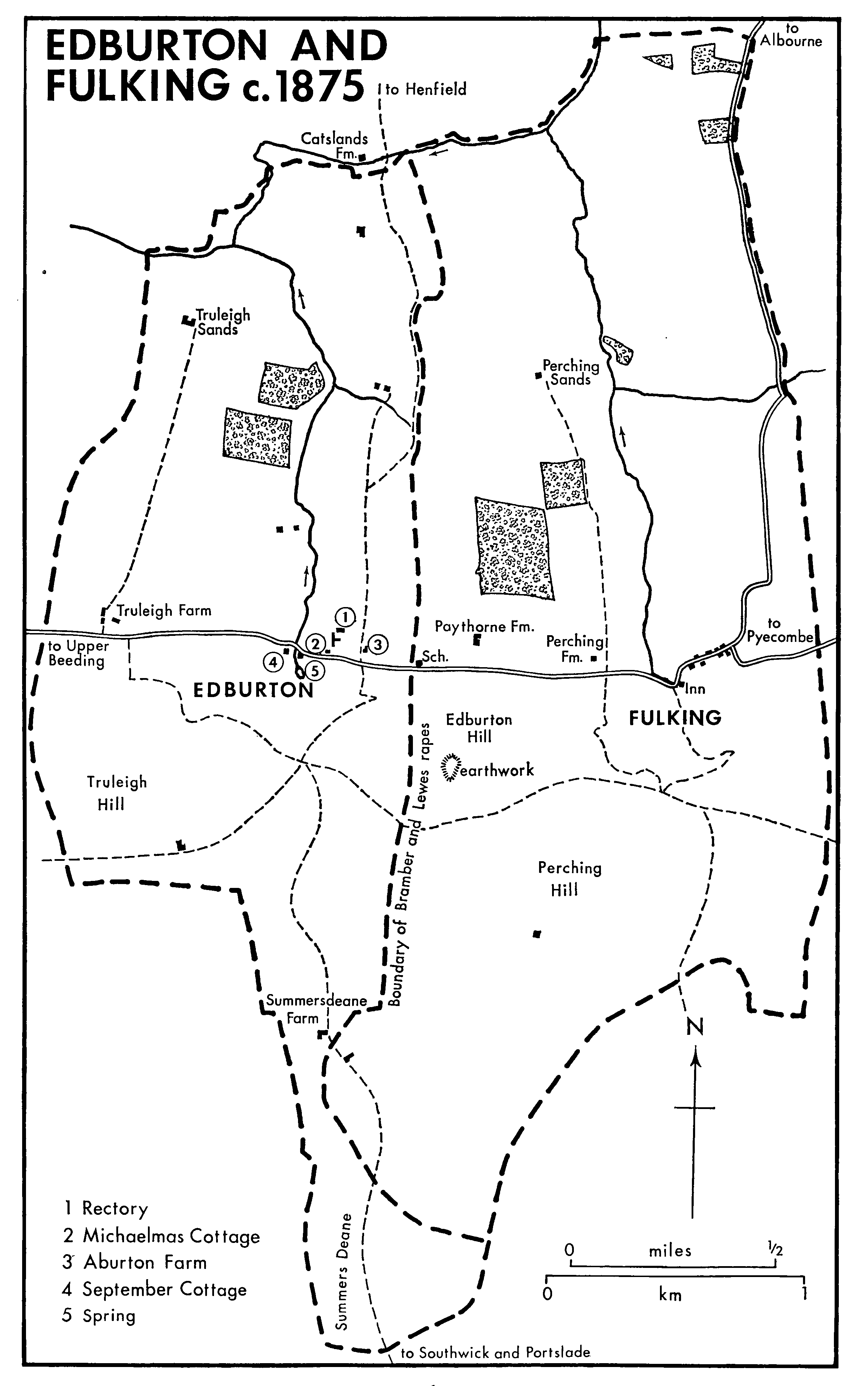
Edburton and Fulking c.1875
The parish shares the varied geology of neighbouring parishes. (fn. 7) The southern part lies on Chalk, overlaid in places by clay-with-flints and Tertiary debris. The scarp is particularly steep, (fn. 8) but beyond it the land slopes gently towards the sea, the southern tongue of the parish forming the dry valley called Summers Deane. North of the Chalk are successive east-west bands of Greensand and clay; the Upper Greensand at the scarp foot carries the sites of Edburton village and Truleigh Farm, the land falling away quite steeply below it. The parish drains north and west towards the river Adur, the most important stream rising in a spring 300 yd. south-west of the church. There was much woodland in the northwest part of the parish in 1780, (fn. 9) some of which remained in 1975. (fn. 10) The ecclesiastical parish contained 124 a. of woods c. 1841. (fn. 11)
The downland in the southern part of the parish is crossed by many tracks, some early. Notable are the road near the crest, part of the chief east-west road through Sussex in the Middle Ages and later; (fn. 12) the marked hollow-way which climbs the scarp from Truleigh Farm in the west and the terraceway which ascends it from Edburton village in the east; and the road through Summers Deane to Southwick and Portslade. All those roads lead to a junction near the head of the Summers Deane valley. The east-west road below the downs, mentioned in 1343, (fn. 13) was also a through route in the past, (fn. 14) and was the Upper Beeding to Pyecombe road in 1984. Another road, mentioned from 1634, ran north-south from Henfield to Edburton village by way of Terry's Cross in Woodmancote and Catsland Farm; (fn. 15) part of it, called Edburton Drove in the 1870s, was followed by the boundary between Bramber and Lewes rapes. (fn. 16) A daily bus service between Brighton and Henfield passing through Edburton was started in 1928 and in 1958 ran at three-hour intervals. (fn. 17)
There are sites of two possible Iron Age settlements in the southern tip of the parish, (fn. 18) and a probable Roman cemetery was found nearby c. 1805. (fn. 19)
The village of Edburton occupies the Upper Greensand bench below the downland scarp. (fn. 20) Three buildings stand close to the church: to the south Michaelmas Cottage, and to the north-east the rectory, called Edburton House in 1984, (fn. 21) and Aburton Farm, the manor house of Edburton manor. (fn. 22) Michaelmas Cottage is a small 16th-century timberframed house with a crown-post roof. A chimneystack and an upper floor were inserted into the former open hall in the 17th century, and the house was at some time shortened to the north and extended to the south. (fn. 23) West of those buildings and beyond the stream is September Cottage, another small 16th-century timber-framed house formerly with an open hall, some of the smoke-blackened rafters of which survived in 1984. A chimneystack and an upper floor were added later, and the west end was extended or rebuilt in the 17th century. (fn. 24) There were other houses nearby in the mid 19th century. (fn. 25) A third of a mile north-west of the church was a group of houses called Lower Edburton in 1851; (fn. 26) one of two surviving timber-framed examples, Truleigh Cottage, incorporates a long range perhaps of the 16th century, with two inserted chimneystacks. (fn. 27) The settlement may be the Northtown commemorated by a surname recorded in 1332. (fn. 28) Five more houses formerly stood alongside the track leading from September Cottage to Lower Edburton, giving rise to the adjacent field name Town field; they were demolished between 1780 and 1813. (fn. 29)
Truleigh Farm occupies the same Upper Greensand outcrop as Edburton village, forming another link in the chain of closely spaced settlements at the downs' foot which includes Tottington in Upper Beeding to the west and Perching and Fulking to the east. The name may describe either a clearing beside a conduit or drain, or one marked by prominent or isolated trees. (fn. 30) There is no evidence of a nucleated settlement. In the 19th century some flint farm cottages were built south-west of the farmhouse; they were still occupied by farm tenants in 1984. Other sites of settlement in the past included Summersdeane Farm in the south and Truleigh Sands and Edburton Sands farmhouses in the north. (fn. 31)
The early 18th-century rector George Keith described his parish as a remote place, in which he felt 'as it were buried alive'; it contained a large number of poor people and no substantial parishioners of a kind to support missionary societies. (fn. 32) In the 18th and 19th centuries Michaelmas, September, and Truleigh Cottages were all in multiple occupation. (fn. 33) A pair of model cottages at Edburton Sands was built by the Crown Estate before 1867, (fn. 34) but was later demolished. In 1901 there were only 16 houses in the parish. (fn. 35) Some further scattered houses were built in the 20th century, but Summersdeane Farm was demolished during the Second World War and not rebuilt. (fn. 36)
Nine tenants of Truleigh manor were listed in 1086. (fn. 37) Fifteen inhabitants of Edburton tithing were taxed in 1332, (fn. 38) 62 in 1378, (fn. 39) and 15 in 1524; (fn. 40) the variation in the figures presumably reflects the assessment of different areas at different times. Totals of numbers of inhabitants in the 17th and 18th centuries refer to the ecclesiastical parish: there were 53 adult males in 1642 (fn. 41) and 20 families in 1717, (fn. 42) but the figure of 200 adults given in 1676 (fn. 43) seems certainly too high. There were 91 inhabitants in 1801, 101 in 1831, 93 in 1871, and 134 in 1891. The total thereafter declined to 83 in 1931; (fn. 44) later figures are subsumed in the totals for Upper Beeding.
A society for young men aged between 14 and 28, apparently run by the rector, had nineteen members in 1833. (fn. 45) A parish hall, succeeding an earlier recreation room, was built in the 1920s in Fulking, (fn. 46) where inhabitants of Edburton still found their social life in 1958 (fn. 47) and later.
Water was still supplied from wells in the mid 20th century. (fn. 48) In 1904 there was also a small waterworks for local supply near Edburton spring; (fn. 49) it survived in 1958, when water was distributed thence by hydraulic rams installed to serve Aburton and Truleigh farms. Electricity was available for most dwellings by the same date. (fn. 50)