A History of the County of Somerset: Volume 7, Bruton, Horethorne and Norton Ferris Hundreds. Originally published by Victoria County History, London, 1999.
This free content was digitised by double rekeying. All rights reserved.
A P Baggs, M C Siraut, 'Henstridge', in A History of the County of Somerset: Volume 7, Bruton, Horethorne and Norton Ferris Hundreds, ed. C R J Currie, R W Dunning (London, 1999), British History Online https://www.british-history.ac.uk/vch/som/vol7/pp108-119 [accessed 30 April 2025].
A P Baggs, M C Siraut, 'Henstridge', in A History of the County of Somerset: Volume 7, Bruton, Horethorne and Norton Ferris Hundreds. Edited by C R J Currie, R W Dunning (London, 1999), British History Online, accessed April 30, 2025, https://www.british-history.ac.uk/vch/som/vol7/pp108-119.
A P Baggs, M C Siraut. "Henstridge". A History of the County of Somerset: Volume 7, Bruton, Horethorne and Norton Ferris Hundreds. Ed. C R J Currie, R W Dunning (London, 1999), British History Online. Web. 30 April 2025. https://www.british-history.ac.uk/vch/som/vol7/pp108-119.
In this section
HENSTRIDGE
The parish of Henstridge lies 5 km. north-east of Milborne Port and on the Dorset boundary. It is roughly rectangular with an extension eastwards to include marshland beside Bow brook and the river Cale and measures 3 km. from north to south and 7 km. from east to west at its widest point. It includes the substantial village of Henstridge and the hamlets of Henstridge Ash, Whitechurch, and Yenston in the centre of the parish, and Toomer and Bowden to the west. It is bounded on the south and south-west by roads and a footpath known as Landshire Lane which form the boundary with Dorset. Parts of the northern and western boundaries are marked by streams. (fn. 1) The parish covers 1,721 ha. (4,253 a.), having lost a few detached fields to Milborne Port in 1885 (fn. 2) and very small areas to Dorset in 1966 when the boundary was moved to accord with the modified course of the Cale and the Bow brook. (fn. 3)
In the east the land lies below the 70-m. (250-ft.) contour on Oxford Clay and was largely occupied in the Middle Ages by a park. (fn. 4) In the centre of the parish, where the land rises sharply to 100 m. (325 ft.), a narrow strip of Cornbrash limestone runs north–south, giving the parish the main element of its name, (fn. 5) and providing the sites of Henstridge village and the hamlets of Yenston and Whitechurch. Further west the land rises more gently over Forest Marble clay and Upper Fuller's Earth, much of the area formerly wooded, (fn. 6) to a ridge reaching just over 145 m. (475 ft.) south of Bowden before dropping rapidly to the western boundary with Milborne Port parish. (fn. 7)
The Castle Cary–Stalbridge road was turnpiked by the Blackmore Vale trust in 1824. (fn. 8) The Shaftesbury–Sherborne road, mentioned as a muddy way in 1411 (fn. 9) and decayed in 1647, (fn. 10) was known as the Causeway or London road in 1707. (fn. 11) It was turnpiked by the Shaftesbury and Sherborne trust in 1752–3. (fn. 12) Henstridge Ash, at the junction of the two roads, was the site of an inn, a carrier's yard, and a smithy. (fn. 13) A gate was set up by Bow Bridge, then a probable medieval structure of two arches and a central cutwater across Bow brook. At the west end of the parish the gradient was lowered in 1823. (fn. 14) Landshire Lane, which follows the Somerset–Dorset boundary, may have been an earlier east–west route. (fn. 15)
In 1863 the Somerset and Dorset Joint Railway Company opened a line between Temple Combe and Blandford (Dors.) which ran east of Henstridge village. The small station and line were closed in 1966. (fn. 16) An airfield on 355 a. of the former Selesmarsh estate in the south-east corner of the parish was built between 1941 and 1943. It was used as a naval air training school called H.M.S. Dipper until 1952 and between 1954 and 1957, and between 1953 and 1957 helicopters used for whaling in the Antarctic were serviced there. In 1993 it was a private airfield with charter and servicing facilities. (fn. 17)
Neolithic arrowheads were said to have been found in the woodland west of Henstridge village, probable Iron-Age burials and artefacts on the high ground in the south-west near Toomer, and Roman pottery at both Toomer and Bowden. (fn. 18) The shape of settlement is dictated by the limestone strip which is followed by the north– south route between Castle Cary and Stalbridge. Henstridge village spreads north almost from the Dorset border called Townsend, recorded in the 14th century, (fn. 19) and beyond the junction with the Sherborne–Shaftesbury road at Henstridge Ash, recorded in 1686; (fn. 20) and also both west and east along lanes leading to the marsh. Further north Whitechurch, possibly named from a limestone chapel recorded there in 1292, (fn. 21) follows a secondary lane. Yenston lies along the main north–south route and was known in the 13th to 18th centuries as Edenston, Eynston, or Endeston. (fn. 22) In 1732 there were 30 houses built on the wastes of Henstridge and Yenston manors, apparently on roadside verges. (fn. 23) Building in the 20th century joined Henstridge village with Henstridge Ash and spread south beyond Townsend and east towards the former railway station.
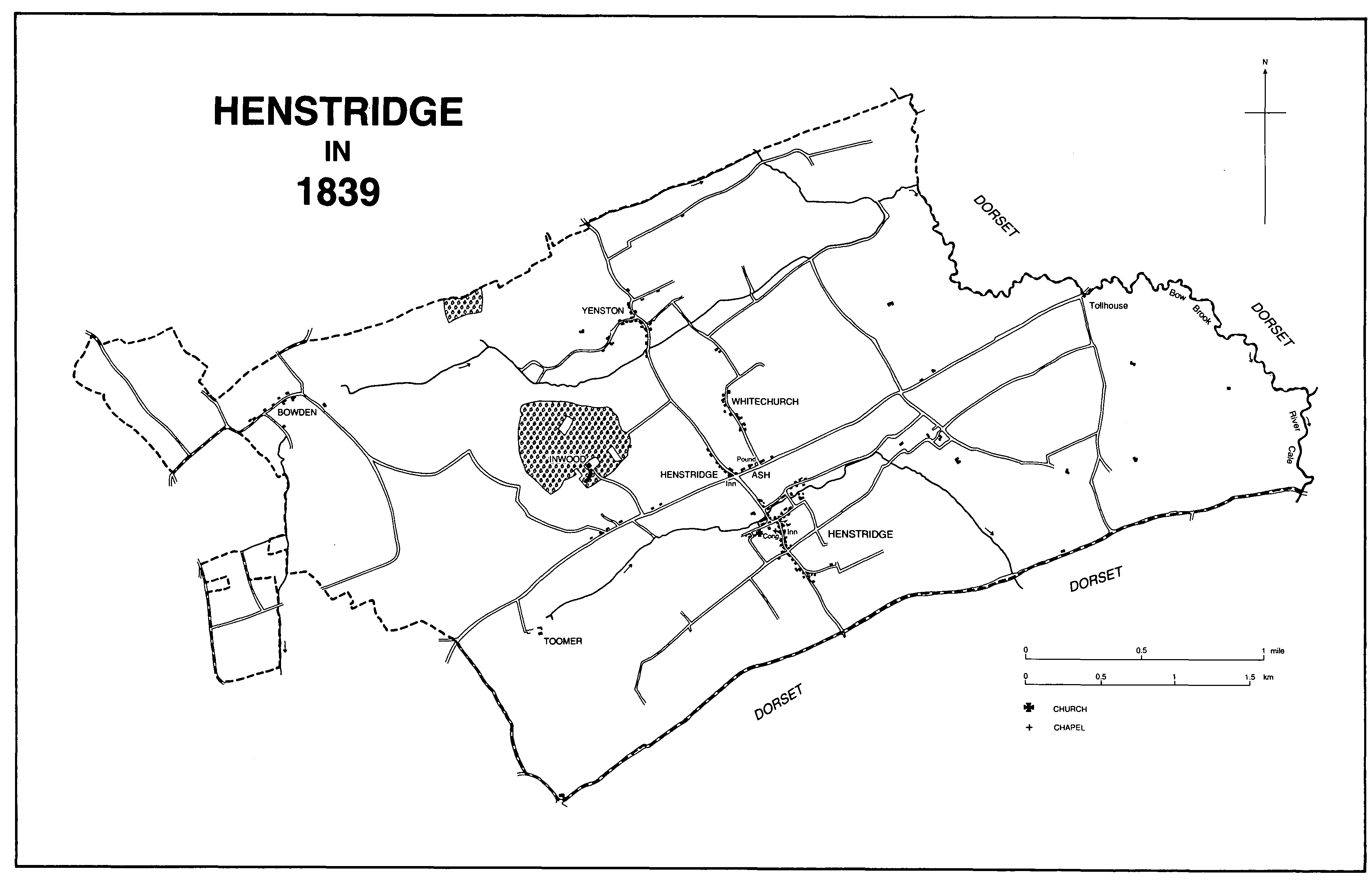
Henstridge in 1839
The older houses are mainly of local stone rubble under tile or slate roofs. Among the larger houses are Pond Farm House, a late 18th-century house later reduced in size and with many features introduced in the 20th century; the early 19th-century Henstridge House and the late 18th-century Cross House in the centre of the village; the former Henstridge Farm, dating from the 17th century, and Oak Vale to the east, said to have been built c. 1815 around an earlier farmhouse using materials from Stalbridge House. (fn. 24)
The Henstridge friendly society was founded in 1799 and in 1822 it had 121 members and a band. (fn. 25) The club day, Whit Thursday, was last held in 1939 and the society was wound up in 1944. (fn. 26) There was a Primrose League reading room in High Street, Henstridge (demolished in 1952), and another at Henstridge Ash, open in 1947. (fn. 27) Before 1880 the vicar established a public coffee room, and a temperance hall above it was opened in 1887. It was converted to a shop between 1947 and 1953. (fn. 28)
There was an inn in the parish in 1619. (fn. 29) In the later 17th century there were several alehouses, probably including one at Yenston. (fn. 30) In 1686 inns at Henstridge and Henstridge Ash provided stabling for 10 horses. (fn. 31) The Duke of Marlborough on Horseback was recorded in 1717. (fn. 32) There were two licensed houses in 1731 and five in 1775. (fn. 33) The Ash or Virginia (fn. 34) at Henstridge Ash, later the Virginia Ash Hotel, (fn. 35) was the meeting place of the friendly society and the Somerset and Dorset Joint Railway Company held its first board meeting there. (fn. 36) The building dates from the 18th century, probably before 1747. (fn. 37) The Rose and Crown, also at Henstridge Ash, was probably open between 1775 and 1822. (fn. 38) The Fountain in High Street, Henstridge, was probably open by 1784 and was rebuilt in the early 19th century when it was known as the New Inn and Fountain. By 1839 it had resumed its old name (fn. 39) and as the Fountain remained open in 1993. South of the Fountain the Three Stars beerhouse was probably open by 1851 but had closed by 1883. (fn. 40) The Bird in Hand on the corner of Blackmoor Lane may have opened in the mid 19th century and remained open in 1993. (fn. 41) The Anchor at Yenston was open between 1841 and 1906. (fn. 42) It was a cottage of the same name in 1993. (fn. 43) The neighbouring New Inn was probably the beerhouse open by 1861 and may have closed between 1923 and 1931. (fn. 44) It was derelict in 1953. (fn. 45) The Royal Oak in Chapel Lane was probably open by 1861. It is said to have closed c. 1970. (fn. 46)
Richard Eburne, vicar of Henstridge 1608–29, published A Plain Pathway to Plantations in 1624 to encourage emigration. (fn. 47) Nicholas Bingham of Henstridge was a leader of the clubmen in 1644. (fn. 48)
In 1641 there were 231 poll tax and subsidy payers in the parish. (fn. 49) In 1801 the population numbered 827 and rose in most decades to 1,146 in 1841, followed by a slight fall; after the arrival of the railway the population rose again to 1,298 in 1881. There was a steady decline in numbers during the early 20th century to 1,040 in 1931 after which the figure fluctuated before rising to 1,337 in 1981 and to 1,443 in 1991. (fn. 50)
MANORS AND OTHER ESTATES
Henstridge, a royal estate in the 10th century, (fn. 51) was held by Earl Harold in 1066. In 1086 it was held by the king. (fn. 52) It was said to have been acquired before 1217 by Hubert de Burgh, earl of Kent. (fn. 53) Overlordship descended with the earldom of Kent as part of the honor of Camel until 1411 or later, (fn. 54) and was held of the king in chief. (fn. 55)
By the earlier 12th century HENSTRIDGE was held by the Camville family like Charlton Horethorne. (fn. 56) In 1545 the manor was purchased from the Crown by Richard Duke and descended with Abbas and Temple Combe. (fn. 57) The marquess of Anglesey did not sell the lordship with the land in 1825 and retained it until 1859 when it was sold to George Wingfield Digby. (fn. 58) The Digby family retained lordship until c. 1900 when it passed to the Guests of Inwood. Lordship was last mentioned in 1939. (fn. 59)
No record of a capital messuage has been found although a manorial granary and barton were recorded in 1485. (fn. 60)
Several estates in the parish were held of Henstridge manor including SELESMARSH manor, which may take its name from the Seles family who held land in the marsh in the 13th century. (fn. 61) The manor was first recorded in 1389 when Thomas de la Bere sold it to John Chitterne. (fn. 62) John was succeeded after 1412 by his sister Agnes, wife of William Milborne, and her son Richard (d. 1451), who bought land there in 1427. (fn. 63) Richard Milborne was followed in the direct male line by Simon (d. 1464), Sir Thomas (d. 1492), Henry (d. 1519), and Richard Milborne (d. 1532), although Henry's widow Margaret (fl. 1541) may have held the manor, (fn. 64) and also Elizabeth Titherley and Mabel Ernle, her daughters by her first husband.
The moiety held by Elizabeth, wife of Robert Titherley (d. 1578), passed to their grandson, also Robert Titherley (d. 1610), and to his son Robert (d. 1638). (fn. 65) Robert, son of the last, with his wife Anne, sold it in 1668 to Henry Whittaker. (fn. 66) In 1690 it was held by Mrs. Whittaker and in 1741 by William Whittaker. (fn. 67) Henry Whittaker held the estate between 1766 and 1797 but by 1814 it had passed to John Barnett, owner in 1821. Known as Lower Syles, it was acquired by William Lambert White between 1832 and 1839. (fn. 68)
The moiety of Mabel Ernle, wife of Henry Uvedale (d. 1599), passed to their sons Edmund (d. 1621 s.p.) and George (d. 1629). (fn. 69) George's daughter and heir Elizabeth, wife of William Okeden, was dead by 1630 and was succeeded by her son Edmund. (fn. 70) Edmund's son or brother William Okeden (d. 1664) was followed by William (d. between 1687 and 1704) and his son William (d. 1718). The last left his estates to his illegitimate sons William (d. 1753) and Edmund (d. 1770). (fn. 71) After extensive litigation Selesmarsh was settled in 1757 on the executors of William Okeden (d. 1753); they sold it to John Calcraft. (fn. 72) It was sold again c. 1787, (fn. 73) probably to Henry Gapper, owner in 1797, whose devisees included the wife of Francis Glossop (d. 1835). Francis held half of Selesmarsh, known as Syles farm, in 1814. From Francis the estate descended like Inwood and in 1876 was sold to Thomas Merthyr Guest. (fn. 74) He appears to have sold it before 1881 to the Dodington family who sold it in 1921. (fn. 75)
There was a house on the Uvedale moiety in 1624. (fn. 76) Late 15th-century gold coins were discovered under a house at Lower Marsh on the other moiety. (fn. 77) Most of the estate was incorporated into Henstridge airfield. (fn. 78)
Bowden, apparently held of Henstridge manor in 1548, (fn. 79) may have originated in lands called Bouedonrew which were held by Adam son of Giles of Blakemore, possibly of John Toomer, in 1374. In 1397 Adam's lands were released by John Toomer to John Fitelton (fn. 80) and were probably held by Joan, widow of Sir John Wadham, in 1412. (fn. 81) Thomas Hussey held BOWDEN manor and had been succeeded by his grandson, also Thomas Hussey, by 1500. (fn. 82) Thomas (d. 1548) was followed by his son Hubert (d. 1554) who held jointly with his wife Elizabeth. Their son Thomas came of age in 1575 and died in 1604 leaving a son, also Thomas. (fn. 83) Thomas or a namesake was alive in 1656 but by 1672 had been succeeded by Joseph Hussey (d. by 1686). (fn. 84) In 1688 Joseph's son Joseph sold Bowden manor to Simon Welman (d. 1707). (fn. 85) In 1709 the manor was settled on Simon's nephew and heir, also Simon (d. 1716), and his wife Elizabeth (d. 1764). (fn. 86) Their son Isaac (d. 1782) was followed by his son Thomas (d. 1829) and grandson Charles, and Charles sold the manor in 1836 to William Manning Dodington. (fn. 87) William also purchased smallholdings at Bowden. (fn. 88) The manor descended with the Dodington estates in Horsington until 1919 when it was broken up and sold, mainly to tenants. Lordship was not recorded (fn. 89) and no capital messuage has been traced.
In 1303 and 1307 Richard of Toomer bought land in Henstridge from John of Wedgewood and others. (fn. 90) It formed the nucleus of the Toomer estate, held of Henstridge manor by 1401, (fn. 91) which was settled in 1317 by Thomas of Toomer on his brother William and on William's son Richard subject to the dower of Margery of Wedgewood. (fn. 92) By 1374 Richard Toomer and his wife Joan had been succeeded by John Toomer. (fn. 93) In 1390 and 1391 John settled his land on himself and on Richard Toomer and his wife Alice. (fn. 94) Richard (d. 1400) was succeeded by his son John, a minor. (fn. 95) John (d. 1407) and his sister Edith (d. 1408) died under age and their lands were held by their grandmother Alice. In 1409 the estate was granted to their aunt Alice, wife of William Carent. (fn. 96) Alice Carent died c. 1414 and William c. 1422 and his son, also William, in 1476. (fn. 97) John (d. 1483), (fn. 98) son of William the younger, was followed in the direct male line by William (d. 1517) (fn. 99) and Sir William (d. 1574). Sir William was in dispute with his daughter Dorothy's husband Thomas Hussey (d. 1573) for possession in 1563–5. In 1574 TOOMER manor was said to have been settled in 1537 on Dorothy for life with successive remainders to her brothers Leonard, William, and John. (fn. 100) In 1578 Dorothy and her husband released their claim to Toomer in return for annuities and Leonard settled the manor on his eldest son William for his marriage to Anne White. (fn. 101) In 1593 William predeceased his father and Leonard took possession, probably during the minority of William's son Maurice, who had livery of Toomer in 1605. (fn. 102) Maurice (d. by 1658) was succeeded in turn by his sons William (d. 1665) and James (d. 1675). James left his estates to be sold to pay debts (fn. 103) and Toomer was bought by Sir Edward Carteret (d. c. 1683). (fn. 104) In 1690 it was held by Sir Edward's widow Elizabeth (d. c. 1700–20), then wife of Alexander Waugh, and by her son Sir Charles Carteret. Sir Charles mortgaged Toomer to James Medlycott in 1696 and sold it to him in 1698. (fn. 105) James added to his estates in Henstridge between 1705 and 1723 and thereafter Toomer descended with Ven in Milborne Port. (fn. 106) In 1909 the Revd. Sir Hubert Medlycott sold Toomer to Elizabeth Augusta Grosvenor Guest of Inwood and it remained part of the Inwood estate in 1993. (fn. 107)
A house was mentioned in 1303, (fn. 108) and the manor house was recorded in 1565. (fn. 109) In 1584 a great gate, porch, gatehouse, middle chambers, kitchen, and pigeon house were mentioned. (fn. 110) Elizabeth Carteret lived there with her second husband in the 1690s but thereafter the building was let as a farmhouse. (fn. 111) The Medlycotts, however, reserved one grand room, chamber, and stable. (fn. 112) Toomer Farm House was largely rebuilt on the same site (fn. 113) in the 19th century but incorporates fragments of 15th- or 16th-century work. It has a 3-bayed front of stone under a slate roof. There is an early 17th-century stone stable block. The 18th-century dovecot has stone exterior walls and brick nest boxes.
Whitechurch Farm, described as a capital messuage, was held of Henstridge manor with surrounding land by Thomas Brightridge (d. 1526–7). Thomas was succeeded by his son Robert (d. 1530–1). Robert's daughter Margaret (d. by 1561?) (fn. 114) married Robert Puncherdon and her daughter Joan (d. 1570) married Robert Pitman (d. by 1586). John Puncherdon, Robert's son by a former wife, entered the estate before 1561 and settled Whitechurch on himself and his wife Thomasine. (fn. 115) By 1582 Thomasine had married Leonard Carent but after prolonged litigation John Pitman, son of Joan, was declared heir to the Brightridge estate which included 20 a. called the escheators lands held of the Crown. (fn. 116) The later descent is unknown and the estate may have been acquired by the Carents. (fn. 117) A manor of WHITECHURCH was said to be held by the lord of Henstridge manor in 1617. (fn. 118)
In the late 1170s Richard de Camville gave the church to form a prebend in Wells cathedral. (fn. 119) In 1294 the advowson of Whitechurch, probably a chapel, was added to the prebend by the lord of the manor, Henry de Lacy, earl of Lincoln (d. 1311) and his wife Margaret. (fn. 120) In 1650 the prebend was sold to Edmund Harvey of London and Richard Aldworth of Bristol possibly in trust for Bristol Corporation and the corporation assigned it in the same year to William Carent of Toomer. (fn. 121) Successive prebendaries let the estate from 1661 until 1855 when the prebend was vested in the Ecclesiastical Commissioners. (fn. 122)
The rectory was assessed at £16 13s. 4d. in 1291 and 1351 (fn. 123) and at £14 net in 1535. (fn. 124) In 1650 it comprised a barn and five closes. (fn. 125) In 1775 there was over 75 a. with some common rights, corn and hay tithes, and small tithes on two small pieces of land. (fn. 126) In 1839 the tithes were commuted for a rent charge of £350 and the glebe measured c. 79 a. Some land appears to have been exchanged later and a small quantity was acquired for the vicarage, possibly c. 1884. The remaining 71 a. were sold in 1920. (fn. 127) A house on the holding had been demolished by 1580. (fn. 128)
The Inwood estate appears to have been carved out of ancient woodland belonging to Henstridge manor and Yenston priory. (fn. 129) It was bought by James Medlycott c. 1723 and descended with Abbas and Temple Combe (fn. 130) until 1826 when it was sold to the Revd. Francis Glossop on behalf of his father, also Francis (d. 1835), who had bought land in the parish from the 1790s. (fn. 131) The younger Francis died in 1853 leaving Inwood to his wife Louisa. She released her interest in 1861 to her husband's nephew John James Glossop, who sold the land to Thomas Merthyr Guest in 1876. (fn. 132) Guest died in 1904, his wife Lady Theodora in 1924, and their daughter Elizabeth Augusta Grosvenor Guest in 1960. Inwood was inherited by the Count de Pelet, the owner in 1993. (fn. 133)
Inwood Lodge was built in a cleared area of woodland between 1828 and 1832, (fn. 134) its ornamental grounds including a canal and a folly tower. (fn. 135) The Lodge was demolished and Inwood House was built on its site in 1881. (fn. 136) It is a large, irregularly-shaped, stone house of two storeys with gabled attics. The large entrance was decorated with old Italian ironwork. The grounds were laid out afresh but included the canal and folly. Several decorative structures and figures were added, some imported from Italy, together with three sets of entrance gates with ornate wrought ironwork, a large stable court southwest of the house, water tower, and gasometers. (fn. 137)
Richard of Haydon had an estate in fee in Henstridge in 1268–9, possibly including land at Whitechurch and Selesmarsh. (fn. 138) Richard and his wife Felice acquired more land in 1280. (fn. 139) In 1303 Roger of Haydon was said to hold 1/8 fee (fn. 140) and in 1308 Felice 1/6 fee, both probably of John de Meriet, (fn. 141) whose grandfather Nicholas de Meriet had claimed a virgate in 1242. (fn. 142) In 1336 the estate was settled on John Teysaunt (fn. 143) and his wife Joan who in 1339 held it of Philip de Columbers and his wife Eleanor. (fn. 144) In 1346 John held Roger of Haydon's 1/8 fee (fn. 145) and the unnamed heirs of Teysaunt held 1/8 fee in 1428. (fn. 146) The estate has not been traced further.
An estate, called TORNIE in 1086 (fn. 147) and later TURNEYATE, lay on Milborne hill and was often described as in Milborne Port parish. (fn. 148) It was added to Temple Combe manor in 1086 but only a toft was so recorded in 1505, (fn. 149) the remainder having been divided during the later Middle Ages between the Gulden and Toomer families. (fn. 150) Part was attached to Yenston in 1632. (fn. 151) The Toomer estate in the 17th century included fields known as Great and Little or Lower and Upper Turnyates (later Great Turnwood), and Turnyates Mead. (fn. 152) The Gulden estate descended to Morgan Cowdrey in 1506 like Craft in Hinton St. George, (fn. 153) and to James Hannam, who held it in chief in 1597. (fn. 154) It may have later formed part of Bowden manor where land called Turnwood or Thorent was given to William Medlycott by exchange in 1862. (fn. 155)
An estate at YENSTON, held by Ednod in 1066, was given to the abbey of St. Sever (Calvados) by Hugh, earl of Chester, probably in 1085. (fn. 156) The abbey was confirmed in possession by Pope Adrian IV in 1158. (fn. 157) The size of the estate was increased in 1201 and a priory appears to have been established by 1225. (fn. 158) A prior was last recorded in 1347. (fn. 159) From 1371 the estate was held by the Crown and let to farm, (fn. 160) and in 1441 the rent and reversion were granted to Eton College. (fn. 161) The estate, regarded as a manor by the college, was resumed by the Crown in 1455 and 1461, (fn. 162) restored in 1467 but not effectively returned until 1473. In 1546 the college exchanged Yenston for other estates with the Crown. (fn. 163) In 1547 the manor was granted to Edward Seymour, duke of Somerset (d. 1552), (fn. 164) but, having been presumably resumed by the Crown, was acquired by Richard Duke (d. 1572) and descended like Abbas and Temple Combe manors. (fn. 165)
The priory buildings had been demolished by 1450. (fn. 166) In 1525–7 the site was called Priors Close (fn. 167) but in 1517 there was a house which the tenant had to maintain. (fn. 168)
Sir John Wadham and his wife Joan had an estate at Yenston in 1412 which was given to endow St. Catherine's chantry, Ilminster. (fn. 169) It was sold to Richard Duke in 1548 and descended with Henstridge manor. (fn. 170) It included a capital messuage, known as Cuffe's Farm after the tenant at the suppression of the chantry, (fn. 171) and later as Yenston House. In 1642 Sir John Jacob sold the house and 246 a. to Jonathan Cooth and in 1710 it was settled on Jonathan's grandson John Cooth for his marriage to Mary Coombe. (fn. 172) John had been succeeded by his brother Anthony by 1716 when it was settled on Anthony's marriage. (fn. 173) It has not been traced further.
In 1654 Margaret, widow of Ezekiel Barkham of Wells, purchased a farm in Yenston to endow a school in Wells. The Blue School retained the farm until it was sold in 1990 and 1992. (fn. 174)
ECONOMIC HISTORY
In 1086 there were twenty-seven ploughlands and twenty-four teams, of which seven were in demesne; five on the royal estate, and two on St. Sever's 3½-hide demesne. The former was worked by eight servi, the latter by four. The royal demesne supported 3 riding horses, 1 beast, 22 pigs, and 438 sheep and the abbey had 8 beasts and 5 pigs. The 37 villani and 21 bordars worked 10½ hides; all the villani were on the royal estate. There were 190 a. of meadow and 30 a. and 1 league by ½ league of pasture. The estate called Tornie had ½ ploughland and a freeholder had 9 a. of arable. The St. Sever estate was worth slightly less in 1086 than in 1066. The others had maintained their value but the royal demesne included eight untaxed ploughlands possibly brought into cultivation since the previous assessment. (fn. 175)
In 1086 there was woodland measuring four square furlongs and 1 league by ½ league, and a freeholder had 2 a. (fn. 176) There was extensive woodland in the west of the parish, known as Henwood, partly in Milborne Port, Inwood, and Weake wood. (fn. 177) Part of Henwood had been cleared before 1225. (fn. 178) Most of Weake wood had been cleared by 1689 and Toomer wood (39 a.) on the county boundary was cleared to create a farm between 1689 and 1733. (fn. 179) Henstridge Wood, Inwood, and Prior's wood (fn. 180) measured 140 a. in 1732 but by 1839 only Inwood survived. (fn. 181) In 1905 113 a. of woodland was recorded. (fn. 182)
There was a park by 1298 (fn. 183) and two by 1305 when the east park in the marsh was described as new. The west park on higher ground at Toomer (fn. 184) measured 380 a. in 1448, including 80 a. of wood, (fn. 185) and was increased in size before 1535. (fn. 186) It appears to have been disparked between 1584 and 1605 (fn. 187) but fields were still enclosed with stone walls in 1733. (fn. 188) By the later 17th century the east park was sold off and divided between areas called Moon's or Mohun's (162 a.) and Colborne's parks after tenants. (fn. 189) The farmstead of Mohun's park, on a hill surrounded by the remains of a pale, may have been built shortly before 1632. (fn. 190)
The marshes were being exploited by the 14th century. A park had been formed there by 1305 and the manor of Selesmarsh, south-east of the park, had been established by 1389. (fn. 191) The owners of Selesmarsh had fisheries and common pasture for several hundred sheep and cattle in the 16th century. (fn. 192) Division of the marsh into farms may have taken place in the 17th century when most of the farmhouses there appear to have been built. Shortage of common land seems to have led to cattle, pigs, and horses feeding in the lanes, a practice which was repeatedly forbidden in the early 19th century. (fn. 193) The marsh north of the park appears to have been common meadow and pasture, partly used by tenants of Yenston, (fn. 194) but had been inclosed by 1839, and possibly in the mid 18th century. (fn. 195) One small plot may have been the waste of the manor where Henstridge manor tenants were allowed to put their cattle to drink in the 17th century. (fn. 196)
In 1305 Henstridge manor possessed a herd of over 50 cattle, as well as pigs and plough beasts; poultry and lambs in stock had been received in rents. Wheat, dredge, barley, peas, beans, vetches, and oats were grown and a new granary was built using 47 oaks. Income included rents totalling over £12, sales of pasture including the agistment of affers in the new park and marsh pasture (over £7), pannage of pigs, and sales of grain, underwood, squabs, rents in kind, dairy produce, and animals totalling over £11. Court profits produced over £5 to which was added chevage of 25 neifs. Demesne labour comprised two ploughmen, a carter, a swineherd, a warrener, and a herdsman in summer. (fn. 197) In 1347 Henstridge manor produced an income of £2 5s. from the dovecot, agistment, and sales of works. In 1362 the dovecot was ruinous but wood, underwood, and herbage were sold in the east and west parks and Inwood. There was 100 a. of arable of which half lay fallow, and 20 a. of meadow. (fn. 198) By 1430 the demesne was let and the manorial income of £39 8s. was almost exclusively rents. (fn. 199) By 1485 the rent income had decreased and some land was in hand. There was a small income from pannage, pasture, dairy produce, and underwood, and the parks and granary were let. (fn. 200) The land lay in furlongs and the north field above the marsh ditch was recorded in the early 16th century. (fn. 201) In 1317 the Toomer estate included land in the south field of Henstridge adjoining Toomer park, the north field of Toomer, Bowden field, and north and south Wolfeldes. All of them were inclosed by the late 17th century. (fn. 202) The common arable appears to have lain between the settlements and the higher wooded ground. (fn. 203) By 1580 there was common pasture in the marsh and common meadow in the east of the parish. (fn. 204) The common meadows of South mead and Kittles moor were inclosed in 1849. (fn. 205)
The importance of dairying is reflected in a will of 1604 which included bequests of cheese and calves. (fn. 206) In 1709 one farmer kept 10 cows and 10 heifers for milk and fattened 100 cattle which had ceased to be profitable for milking or draught. He had converted some pasture to orchard and produced 100 bu. of apples. He was said to have 1,100 sheep of which 200 had lambs, 500 were shorn, and the rest were fattened. He also obtained 40 lb. of honey from his bees. (fn. 207) Another farmer, with c. 140 a. in 1715, had 7 dairy cows each producing 5 qts. of milk daily, worth £20 8s. 4d. over 20 weeks. He also fattened 42 oxen, produced 8 bu. of apples and pears, and wintered 120 ewes for their owner. Welsh cattle were bought for fattening in May and sold around Christmas. (fn. 208)
In the later 16th century it was claimed that tenants of Henstridge manor had the right to take wood in Inwood at 2s. an acre and 1d. to the reeve for each yard measured. (fn. 209) The lord had felled a large part of the wood and denied the custom. (fn. 210) By 1580, apart from the marsh, the meadows provided the only common pasture, and were only available between August and February. (fn. 211) Those factors probably contributed to the economic difficulties in the parish in the earlier 17th century. It was said to be burdened with poor in 1625. Fifty years earlier there had been apparently 60 farms and 14 smaller tenements and only 6 cottages without land but by 1625 10 smallholdings had been created out of the farms, 35 cottages had been built on the waste, there were 21 lodgers, and 30–40 tenements were needed to provide for the young people of the parish. The vicar, Richard Eburne, encouraged the poor to emigrate. (fn. 212)
In the early 1780s the estate formerly of Edward Walter probably covered over 800 a., mostly rack rented. (fn. 213) In 1801 408 a. of crops was recorded, mainly wheat, barley, oats, and peas but also potatoes and beans. (fn. 214) In 1830 two threshing machines were destroyed at Henstridge and Yenston. (fn. 215) In the 1830s the staple produce was butter which was sent to London in barrels. Flocks of sheep fed on the higher ground and green crops and grain were rotated on the arable. (fn. 216) In 1839 Nathaniel Bridges, vicar, 1813–c. 1870, had a substantial holding including Pond and Church, formerly Court, farms which were later enlarged as dairy farms. (fn. 217) There were then 740 a. of arable and 3,082 a. of grass in the parish. Yenston (397 a.) and Toomer (359 a.) farms were the largest holdings and there were 9 others over 100 a., 16 more over 50 a., and 26 between 15 a. and 50 a. (fn. 218) In 1851 there were 83 employees on 31 farms and in 1861 35 farms employed 117 labourers. Four farms were over 200 a. in 1861. There was a gradual decline in the number of farms and farm workers and in 1881 there were 29 farms and 92 labourers. (fn. 219) At least three dairymen were recorded in 1841. (fn. 220) In 1858 a dairy with 50 cows was let (fn. 221) and in 1891 there was a cheesemaker. (fn. 222) By 1891 there was a milk factory which was probably processing cheese in 1947. (fn. 223)
In 1905 only 458 a. of arable was recorded and 3,447 a. of grass. (fn. 224) Two farms at Bowden in 1919 had cheeserooms (fn. 225) and in 1921 a farm on the marsh was described as a profitable dairy farm on rich pasture with stalls for 32 cows. (fn. 226) Of 30 holdings returned in 1988, 11 were dairy farms, one reared pigs and poultry, and one produced raspberries, salads, vegetables, and cut flowers. There were 2,084 cattle, 2,106 pigs, 148 sheep, and 143 poultry, ducks, and geese. Of 1,216.5 ha. (3,006 a.) returned, 1,111 ha. (2,745 a.) was under grass. The main arable crops were wheat (26.8 ha. (66 a.)), maize (21.4 ha. (53 a.)), barley (20.3 ha. (50 a.)), and fodder (20.3 ha. (50 a.)). There were eight holdings over 50 ha. (124 a.) of which five were over 100 ha. (247 a.) and 60 people were employed in agriculture. (fn. 227)
Forest Marble was quarried in several places from the later 17th century onwards (fn. 228) and there were at least three limekilns in the parish in the 19th century. (fn. 229)
In 1831 only half the households earned a living from farming and nearly a quarter were engaged in trade and manufacture. (fn. 230) Linen weaving was carried on in the parish from the 17th century until the early 19th; in 1712 a hosier was in business and in 1753 a clothier. (fn. 231) A man described as a linen manufacturer, grocer, dealer, and chapman was bankrupt in 1806. (fn. 232) Gloving had been established by 1841 and by 1851 there were 100 glovers, mainly female, probably outworkers to Milborne Port manufacturers. (fn. 233) In 1871 there were a gloving agent, 152 female glovers, and 5 male glove cutters and finishers. (fn. 234) Numbers of glovers declined to 44 in 1891 when gloves were sewn by machine (fn. 235) but there were still glovers in the parish until 1947 or later. (fn. 236)
The two turnpike roads and later the railway made the village a minor commercial centre. Several carriers, a smithy, a coal merchant, and tea and wool dealers were based there during the 19th century and among the craftsmen were a clock and watch repairer, a watchmaker, and a proprietor of patent medicines in 1851, and a stocking knitter and a milliner in 1861. (fn. 237) The grocer's shop and post office of 1861 had expanded its business to include selling drapery, books and stationery, printing, and binding by 1872 and selling china, glass, ironmongery, oil, and drugs by 1911 when the owner also acted as a shipping and insurance agent. (fn. 238) There was a cycle works in 1891 and 1906 (fn. 239) and a motor engineer in 1923. (fn. 240) In 1947 employment was provided, apart from the milk factory, by the airfield, the railway, and a quarry and among the business were several tradesmen including a hairdresser, three car and two cycle repairers, a chimney sweep, and at least twelve shops. In 1981 industries included agricultural and motor engineers, a car breaker, and a timber merchant; there was a shop in Yenston and six in Henstridge of which two were antique shops. (fn. 241) Several shops had closed by 1993 but there were many workshops on or near the airfield.
Mills
There was a mill on the royal manor in 1086. (fn. 242) It may have been the predecessor of the watermill in Henstridge village which belonged to the Carents in 1609 and descended with Toomer until 1861 when it was sold. (fn. 243) It appears to have been used as a textile mill in 1703 and 1753. (fn. 244) It was occupied by a baker and miller in 1840 and remained in use, powered by water and steam, until 1902 when it was destroyed by fire. (fn. 245) The mill pond has been filled in.
A watermill at Yenston, probably that recorded in the 1520s, (fn. 246) was known as Haskett's mill, after the tenant in 1670. (fn. 247) In 1717 it was sold to James Medlycott (fn. 248) and may have been in use until 1741. (fn. 249) By 1839 it had been demolished and the filled pond was meadow land. (fn. 250)
A mill was said to have been settled by Simon son of Richard Miller on Richard Basset for his marriage to Edith de Bynethelynch. In 1278, following Edith's death, ownership was disputed between her nephew Robert de Bynethelynch and John Ridout. (fn. 251) The site is unknown.
There was probably a windmill in 1317. (fn. 252) A windmill at Yenston in 1607 (fn. 253) presumably lay west of the hamlet on Windmill Hill. Windmill field and hill north of Toomer were recorded in 1609. (fn. 254)
LOCAL GOVERNMENT
Most of Henstridge formed a single tithing in Horethorne hundred and Henstridge manor court appointed a tithingman with a share of South mead. (fn. 255) Courts were held for Henstridge manor four times a year in 1485. (fn. 256) In the 16th century the lord was said to have appointed a reeve contrary to the ancient custom of election by the tenants. (fn. 257) There are records of courts, possibly courts baron, for 1592, 1598, 1606–7, 1620, 1622–3, and 1626. (fn. 258) Records of the autumn court leet for what was known as the liberty of Henstridge survive for 1801–62. The court was concerned mainly with tenancies, impounding, ditch cleaning, and nuisances, and appointed a hayward. After 1859 the court met at the Henstridge Ash inn. (fn. 259) In 1695 the pound may have been west of the church near Pound Lane but by the 1830s it was at Henstridge Ash. (fn. 260) Court rolls for Yenston survive for 1528, 1532, 1535, 1543, 1546, and 1606, and courts may still have been held in 1632. (fn. 261) A court roll survives for Bowden manor for 1741 (fn. 262) and there was a pound there in 1836. (fn. 263)
The prebendary of Henstridge had peculiar jurisdiction in the parish. There are prebendal court papers for 1723, 1783, and 1787 concerning pews, tithes, and probate; (fn. 264) churchwardens' presentments survive for various years between 1684 and 1846, (fn. 265) and lists of wills and administrations 1677–1719 and 1732. (fn. 266)
Poor relief by the late 17th century was in cash and in kind, that in kind known as the fragment. (fn. 267) In 1757 the overseers gave money to French prisoners, (fn. 268) and in the 1750s and 1760s paid for a boy to learn weaving and supplied a loom. (fn. 269) The vestry ordered a special fund for the poor in 1776 and distributions of wheat and peas were made. In 1777 loaves were given and in 1783 the overseers bought 4 a. of timber at Inwood to sell on behalf of the poor. (fn. 270) In the early 19th century coal and wood were bought for resale to the poor. (fn. 271)
In 1736 it was agreed to extend the parish house at Townsend and convert it to a workhouse. Two houses were to be built with chambers over in 1783, probably adjoining the workhouse. (fn. 272) In 1818 the overseers paid for supplies to a new workhouse including food, fuel, and calico, and for moving the paupers and carrying their goods. (fn. 273) The three dwellings at Townsend were ordered to be sold in 1868 and a sale was agreed in 1872, by which date one cottage was in ruins. (fn. 274) In 1825 the parish had at least seven cottages. (fn. 275) In 1747 there was a poorhouse at Henstridge Ash (fn. 276) which may have been retained in 1806 but was disused in 1839. (fn. 277) In 1835 Henstridge became part of Wincanton poor-law union and in 1894 of Wincanton rural district which was absorbed into Yeovil, later South Somerset, district in 1974. (fn. 278)
There was a resident police constable in the village between 1841 and 1947. (fn. 279) A fire engine was housed in a shed by the mill pond in the early 1900s. (fn. 280) Henstridge shared a sewers jury in 1793 with Temple Combe and there was later a joint water committee. (fn. 281)
CHURCH
When the church was given in the 1170s to form a prebend at Wells Cathedral there was already a rector. (fn. 282) A vicar had been appointed by 1276. (fn. 283) The living remained a sole vicarage until 1979 when it became part of the united benefice of Henstridge with Charlton Horethorne and Stowell. (fn. 284) The advowson was exercised by successive holders of the prebend until 1855 when the bishop became the patron. The bishop presents for two turns in three in the united benefice. (fn. 285)
The vicarage was assessed at £4 6s. 8d. in 1291 (fn. 286) and at £13 os. 2½ d. net in 1535. (fn. 287) In 1651 the minister was allowed £75 a year, (fn. 288) and from 1661 until 1841 or later the vicar received £20 from the farmer of the prebend. (fn. 289) In 1829–31 the average income of the vicarage was £450 gross (fn. 290) and in 1839 the vicarial tithes were commuted for a rent charge of £550. (fn. 291) No vicarial glebe was recorded in 1535 (fn. 292) but by 1662 the vicar had a homestead. (fn. 293) A small quantity of land was acquired c. 1884. (fn. 294) In 1662 there was a vicarage house with a decayed kitchen. (fn. 295) In 1879 the house, of two storeys and attics, had a two-roomed main range with central door and a rear kitchen wing with single-storeyed extensions. The house was said to be very old and dilapidated and major alterations were carried out. (fn. 296) A new vicarage house of red brick was built in 1956 behind the old house, which was sold in that year. (fn. 297)
Robert the vicar was murdered c. 1276. (fn. 298) Robert Russe, instituted in 1413, was required to obtain a book on the sacraments, commandments, and articles of faith and to study the contents. (fn. 299) A chantry chaplain was recorded in 1450 (fn. 300) and a chaplain in the 1530s. (fn. 301) There was a brotherhood of Our Lady in 1525 and stores of St. James and St. Clement, (fn. 302) and before 1548 an endowed light. (fn. 303) A church house was recorded in 1629. (fn. 304)
In 1731 the churchwardens gave money to encourage the choir and the overseers paid for their instruction in 1771. An organ was introduced in 1835. (fn. 305) In 1815 there were two Sunday services with sermons. (fn. 306) In 1851 attendance averaged 240 in the morning and 200 in the evening. (fn. 307) Monthly communion was celebrated in 1870 and both vicar and curate were resident. (fn. 308) The choir was surpliced in 1873. (fn. 309)
The church of ST. NICHOLAS, dedicated to St. Michael by 1294 and until the late 18th century, (fn. 310) has a chancel with north chapel and south vestry with organ chamber, a nave with north and south aisles and south porch, and a west tower. The medieval church consisted of a chancel with north chapel known as the Lady or Toomer aisle (fn. 311) and south-east vestry, a nave with north aisle and south porch, and a west tower. (fn. 312) The north-west corner of the tower has 13thcentury buttresses and the nave was long and narrow with a thick south wall suggesting a 12th-century or earlier origin. The church was consecrated in 1332 with four altars. (fn. 313) The porch was added in the 14th century and perhaps also the north chapel and the vestry. The north aisle was built in the 15th century when the upper part of the tower and several windows were renewed.
During necessary (fn. 314) restoration in 1872–3 by J. M. Allen, the vestry was demolished, the chancel extended, the north arcade and part of the north wall rebuilt, and on the south side an aisle, porch, vestry, and organ chamber were added, the last replacing the west galleries. Allen also rebuilt the upper stage of the tower. (fn. 315) A new tower was proposed in 1880–1, (fn. 316) and the old one almost entirely replaced in 1900 by a taller structure designed by Edmund Buckle. (fn. 317) During the restoration a fresco of St. Christopher was found on the north wall of the church with the arms of Carent and Toomer and miniature paintings of a windmill with figures and a church with a monk carrying a lantern. (fn. 318) Preserved from the medieval building are a 15th-century blocked doorway in the north aisle, the font, the canopied recess in the north chancel chapel, and the tomb of William Carent and his first wife Margaret Stourton erected after her death in 1463. (fn. 319)
The oldest of the six bells is by Richard Purdue dated 1615 and another is by Thomas Purdue, dated 1673. (fn. 320) The plate includes a cup and cover of 1574 by R. Orenge and a salver of 1698 given by William Churchey in 1727. (fn. 321) The registers date from 1653. (fn. 322)
The base of a possibly late 13th-century cross stands in the churchyard.
A chapel at Whitechurch, mentioned in 1292, was not recorded again and its site is unknown. (fn. 323) There was a chapel at Yenston in 1380 with an endowment for a chantry. It was last recorded in 1396. (fn. 324)
NONCONFORMITY
A man from Henstridge was an elder of the Wells and Bruton Presbyterian classis during the Interregnum and another was fined for attending a Quaker meeting in 1680. (fn. 325) There was a Presbyterian in the parish in 1716 (fn. 326) and licences were issued for a meeting of unspecified denomination in 1704, for Baptists at Bowden in 1735, for two Independent meetings at Yenston in 1748, and for Presbyterians in 1763. (fn. 327) Licences for unspecified denominations were granted in 1811 and 1833. (fn. 328)
Independents met at Henstridge in 1797 and a house was licensed for meetings in 1805. (fn. 329) In 1834 a chapel was built for 240 and was licensed in the following year. There were two Sunday services in 1851 and the chapel was served from Milborne Port. (fn. 330) By 1861 there was a resident minister. (fn. 331) The chapel had been rebuilt by 1896 (fn. 332) and closed c. 1993–4. (fn. 333)
A Wesleyan minister lived at Henstridge in 1841 (fn. 334) and in 1845 a chapel was built. Services increased from fortnightly to weekly in 1846. (fn. 335) The chapel, in High Street, was rebuilt in 1899, closed c. 1970, and was converted into a dwelling. (fn. 336) In 1845 a house and a new chapel were registered for Wesleyan meetings at Yenston (fn. 337) and services were held weekly from 1846. (fn. 338) The chapel was rebuilt in 1884 and remained open in 1981 but was not recorded in 1991. (fn. 339) A Primitive Methodist chapel was open in Yenston before 1867 and was last recorded in 1926. (fn. 340) A timber chapel, denomination unknown, stood at Lower Farm, Bowden, in 1927. (fn. 341)
EDUCATION
A malthouse had been converted to a schoolroom by 1813 and there was a Sunday school for 100 children in 1819. (fn. 342) In 1833 it was attended by 120 children, and 50 attended a day school supported by the vicar, who had built a new schoolroom east of the vicarage house. (fn. 343) By 1846 there were two schools educating 109 children daily and on Sundays; a further 194 children attended only on Sundays. Both were supported entirely by the vicar. (fn. 344) A National school was built in 1872 and had 7 teachers and 242 pupils in 1903. (fn. 345) Average attendance declined to 130 in 1925, but improvements were made in 1928 and attendance rose to 153 in 1935. The school accepted voluntary controlled status in 1952. (fn. 346) In 1993 there were 84 children aged 4–11 on the register. (fn. 347)
A boys' boarding school had been opened by 1840 and had 7 pupils aged 8–15 in 1841. (fn. 348)
CHARITIES FOR THE POOR
Mary Misenor by will dated 1792 gave £105 to the poor but £31 given by Mr. Brooks and others had been lost by 1824. (fn. 349) The parish also had a share in Rolt's and Brine's charity of Abbas and Temple Combe (fn. 350) and received the income from the poor houses, a gift of unknown origin last recorded in 1840. (fn. 351) By will proved in 1878 R. Coombs gave £200 to the poor but that gift appears to have been lost. (fn. 352) In the 1880s distributions from Rolt's, Brine's, and Misenor's charities were made every three years and in 1895 the income was used to buy coal. (fn. 353) Under a scheme of 1984 the combined income of £12 is used for relief in need. (fn. 354)