A History of the County of Chester: Volume 5 Part 1, the City of Chester: General History and Topography. Originally published by Victoria County History, London, 2003.
This free content was digitised by double rekeying. All rights reserved.
'Topography 900-1914: Victorian and edwardian, 1840-1914', in A History of the County of Chester: Volume 5 Part 1, the City of Chester: General History and Topography, (London, 2003) pp. 229-238. British History Online https://www.british-history.ac.uk/vch/ches/vol5/pt1/pp229-238 [accessed 19 April 2024]
In this section
VICTORIAN AND EDWARDIAN, 1840-1914
Chester's appearance in 1914 had been largely determined by the new building and reconstruction of the previous seventy years. By then a remarkable modern commercial centre had been created, clothed in the antiquarian styles of the vernacular revival. There had also been considerable, if much less distinctive, suburban development, and on the rural fringes there was a scatter of middle-class villas and, towards the end of the period, terraced housing produced by speculative builders.
The City Centre
The city centre was tranformed between 1840 and 1914 by improvements to the street plan, the erection of a number of large public buildings, and above all by the rebuilding of many commercial premises in the half-timbered styles of the vernacular revival.
To the south of the city the most significant alteration to the street plan was the building of Castle Drive in 1901 to provide an elegant link around the south side of the castle between Grosvenor Road and the Bridgegate. (fn. 1) In the south-east of the intramural area a small group of new streets was built on the former gardens of the Albion Hotel: Albion Place, Albion Street, and Volunteer Street were laid out in the mid 1860s (fn. 2) and Steele Street was added in the 1880s, partly on the site of Roberts' and Wilkinson's Courts. (fn. 3) All four streets had terraced working-class housing. The centrepiece of the area was the new Volunteer Drill Hall, erected by public subscription in 1869 at a cost of £2,500. Built of red sandstone in an 'Edwardian castellated' style, it was for the use of the Chester Artillery and Rifle Volunteers. An extension of the building through to Duke Street in the 1900s resulted in the demolition of almshouses and two courts. (fn. 4) Only the front elevation survived in 2000.
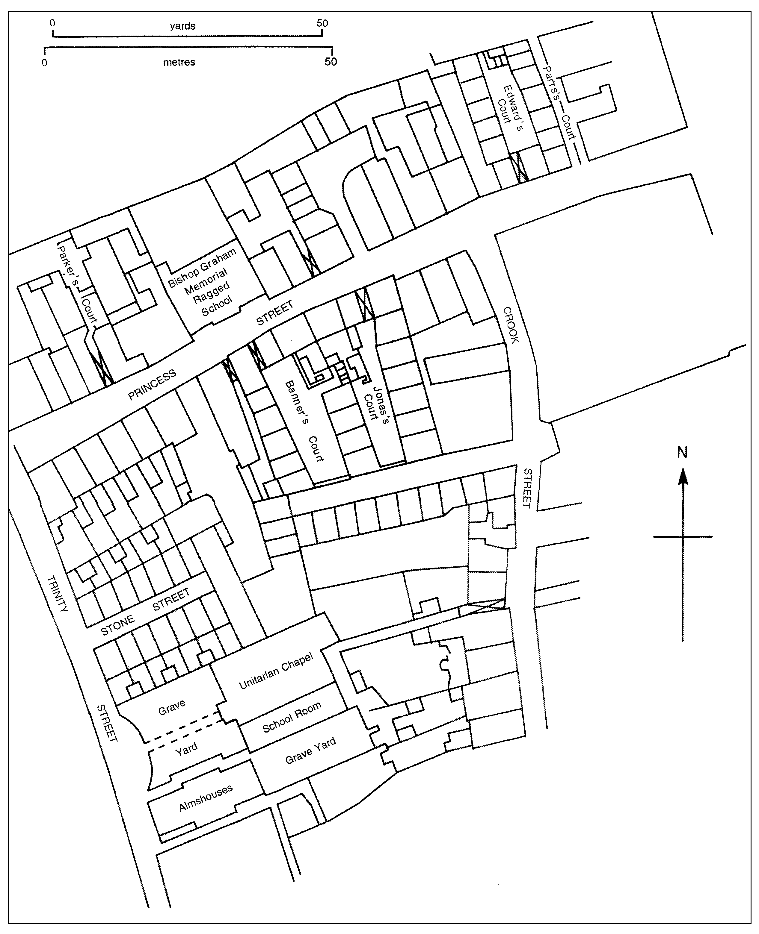
An area of courtyard housing in the city center, 1875
St. Werburgh Street was converted after 1845 from a 'narrow and incommodious' street, 'occupied principally by deformed masses of unseemly buildings', (fn. 5) into a fitting approach to the cathedral. Its improvement began with the demolition of the old linen hall, by then dilapidated and used for warehousing and workshops. (fn. 6) Between 1867 and 1874 the dean and chapter and their lessee completely redeveloped the property opposite the cathedral, (fn. 7) while the entrance from Northgate Street was enlarged by demolition on the south side and setting back the frontage of the new King's school building of 1876 on the north side. (fn. 8) The transformation of St. Werburgh Street was completed in the mid 1890s by the widening of its southern end and the erection of John Douglas's spectacular range of half-timbered buildings on the eastern side. (fn. 9)
Major changes were made to central Northgate Street in the 1860s. In 1863 a new public market with an ornate baroque façade was opened adjacent to the site of the Exchange. (fn. 10) The building of the market coincided with the destruction of the Exchange by fire in 1862, and a competition was held for designs for a new town hall. It was won by W. H. Lynn (1829-1915) of Belfast, and his building, in 13th-century Gothic style with a central tower, steeply pitched tiled roofs, and corner turrets, was completed in 1869. (fn. 11)
In the west of the intramural area there were two notable developments. A barracks for the Cheshire Militia was built in the 1860s on the west side of Castle Esplanade on the site of the nunnery, an area which had remained largely undeveloped since the 17th century. (fn. 12) The Queen's school was built in 1882 on the site of the old city gaol in City Walls Road. Designed by E.A. Ould, a pupil of John Douglas, it was in 'Tudor Gothic' style with patterned brickwork. (fn. 13)
The formation of the Chester Archaeological Society in 1849 created a forum through which half-timbered vernacular revival styles of architecture were promoted in Chester. (fn. 14) An anonymous author in the society's Journal argued in 1857 for the retention of 'ancient landmarks', the restoration of old houses, and the erection of new ones 'after the same distinguishing type'. (fn. 15) The vernacular revival made its impact through the extensive rebuilding of city-centre premises between the 1850s and 1914, a process reflecting growth in Chester's service economy during the period. The rebuilding, bringing a distinctive style of architecture which established Chester's urban identity and accounted substantially for its popularity as a tourist destination in the 20th century, occurred in four main phases. The first, from 1850 to 1865, was clearly the result of Chester's mid-century economic boom. There was then a short flurry of activity c. 1873, linked possibly to the national economic upturn of the early 1870s. A third phase lasted from 1888 to 1902 and can be explained by Chester's somewhat improved economic performance around the 1890s. A final spurt after 1909 was cut short by the First World War. Redevelopment was concentrated almost entirely in Eastgate and Bridge Streets in the first two phases but later spread to Northgate and Foregate Streets. (fn. 16) Watergate and Lower Bridge Streets, on the other hand, declined increasingly into picturesque decrepitude. (fn. 17)
The half-timbered revival in Chester was pioneered by the architect Thomas Mainwaring Penson (1818- 64). His first building in the style was erected in 1852 in Eastgate Street and he was also responsible for the expansion of Browns' shop in 1857-8, a scheme which produced adjacent buildings of wildly differing styles, one proto-vernacular revival and the other 13th-century Gothic. In the earliest phase the halftimbered style was not universal, and was breached most notably by George Williams's classical stone building for the Chester Bank at the corner of Eastgate and St. Werburgh Streets. Williams and Penson, as well as James Harrison (1814-66) and to some extent Edward Hodkinson, were nevertheless instrumental in initiating the revival style in Chester, but in their work the styling lacked depth, the timbering was insubstantial, and the detailing was devoid of historical accuracy. (fn. 18)
The next generation of architects adopted a more scholarly and disciplined approach. The dominating figures were John Douglas (1830-1911) and Thomas Meakin Lockwood (1830-1900), but others, including H. W. Beswick, James Strong, W. M. Boden, and Thomas Edwards, were also active. The work of Lockwood, a local man much patronized by the Grosvenors, was perhaps best exemplified at the Cross. In 1888 he was responsible for one of the best known groups of vernacular revival buildings in Chester, no. 1 Bridge Street, on the eastern corner of Eastgate and Bridge Streets, and in 1892 he designed those on the opposite corner, between Bridge and Watergate Streets, a more eclectic composition with renaissance and baroque elements in stone and brick interwoven with halftimbering. (fn. 19)
An even more distinguished contribution was made by another architect much employed by the Grosvenors. John Douglas was perhaps the most successful exponent of the vernacular revival in Chester. (fn. 20) His work had a strong sense of craftsmanship and sensitivity to materials, exemplified by his best buildings in the city such as the east side of St. Werburgh Street (1895-9), Shoemakers' Row in Northgate Street (1899), and no. 38 Bridge Street. (fn. 21) Not all of Douglas's many buildings in Chester were in half-timbered style. Notable exceptions were the Grosvenor Club and North and South Wales Bank, Eastgate Street (1881- 3), and the Cheshire county constabulary building, Foregate Street (1884), both of brick in a style derived from late medieval Flanders. (fn. 22) Equally distinguished, though modest in scale, was a terrace of houses in Bath Street dating from 1903 and built of sandstone with conical-roofed turrets. They combined with the Prudential Assurance building on Foregate Street, also of 1903, to produce an attractively irregular townscape. (fn. 23)
Besides new building, there was much 'restoration' of earlier half-timbered building in the city centre. James Harrison, for example, reconstructed God's Providence House, Watergate Street, in a fashion later found highly unsatisfactory by local antiquarians. T. M. Lockwood was responsible for the restoration of Bishop Lloyd's House (no. 41 Watergate Street) in 1899-1900, in the course of which major alterations were made to the façade and detailing. For its date it was nevertheless a reasonably sensitive piece of work which retained some notable interior features. The conservation movement in 19th-century Chester was still at a rudimentary stage and extensive archaeological remains were destroyed during redevelopment, often without being properly recorded. (fn. 24)
The vernacular revival in Chester was not without its critics, and the architect W. T. Lockwood made a determined, though ultimately unsuccessful stand against it. In 1910 he was responsible for the most controversial building erected in Chester for half a century, the St. Michael's Row development in Bridge Street for the duke of Westminster. The dramatic fourstoreyed frontage, dubbed immediately 'the White City', utilized white and gold faience tiling and provoked a storm of hostility so severe that the duke bowed to the pressure and in 1911 ordered the whole façade to be demolished and replaced in half-timbered style. The resultant structure apparently appeased contemporary critics. By 1914 the vernacular revival had run its course in Chester, but by then the Victorian redevelopment of Eastgate Street, Northgate Street, and Bridge Street had transformed a nucleus of modest domestic brick and timber buildings into a shopping centre of metropolitan appeal. (fn. 25)
The rebuilding described above served to accentuate the contrast between the prosperous parts of the urban core and other areas of more limited growth or even decline. (fn. 26) Rating evidence for the later 19th century shows that Eastgate Street retained its place as the commercial heart of Chester and that Bridge Street, Foregate Street, and Northgate Street also prospered. In each of the last three streets the number of separate premises diminished as small businesses were squeezed out by the expansion of bigger and more successful shops. Elsewhere the situation was quite different. Lower Bridge Street and Watergate Street experienced economic decline as property became increasingly subdivided, a process reflecting colonization by small, often marginal businesses needing cheap premises. In Frodsham Street development seems to have intensified as an offshoot from the central area because its location served customers from working-class suburbs in the north of the city. Overall, however, Chester's central area saw little absolute expansion in the 19th century. City Road, laid out in the 1860s to provide more convenient access to the railway station, would have been a natural line of growth if the commercial centre had been expanding, yet it developed only slowly and included few shops. (fn. 27) Landowners and developers preferred to invest in the old established core. The Grosvenors in particular had acquired much land in the city centre in the previous 150 years and were very active in the redevelopment of sites and buildings there between 1850 and 1914. In Bridge Street, for example, they were not only the biggest owners of both sites and buildings but their holdings were in the higher-value properties. The Grosvenor development of the St. Michael's Row arcade in 1910-11 markedly expanded Bridge Street's commercial area, though only half the shops had been let by July 1913. (fn. 28)

North and South Wales Bank and Grosvenor Club
The attractiveness of the city centre for shopping and social intercourse was enhanced by the 1845 Chester Improvement Act, which gave the council stronger powers to repair and drain streets and set minimum road widths. It also clarified responsibilities for maintaining the Rows and footpaths. (fn. 29) With the opening of the public market building in 1863, markets and fairs were removed from the streets, (fn. 30) and other disreputable inheritances from the past were suppressed, such as the mug market in St. Werburgh Street. (fn. 31) The fortunes of Northgate Street were improved by the removal of the flesh shambles and the erection of the new town hall. Those changes allowed the creation of Market or Town Hall Square as a more formal incident in the progression of the street. (fn. 32) Its northern end was enhanced in 1911 by the erection of the fire station, designed by James Strong in half-timbered style. (fn. 33)
Industrial Buildings
Although Chester's industrial base remained relatively modest after 1840, (fn. 34) the city nevertheless developed areas with a Victorian industrial and urban character grafted rather incongruously on to the ancient core. Indeed, the city centre became ringed on its western, northern, and north-eastern sides by areas of industry, housing, and railways little different from those in the region's younger manufacturing cities and towns, while Saltney, straddling the Flintshire border, was Chester's own 'miniature Black Country'. (fn. 35)
The Gorse Stacks and Brook Street area was the main industrial centre on the edge of the older urban core, with foundries, engineering works, saw mills, tanneries, and a chemical works. (fn. 36) After 1875 the site of the Flookersbrook Foundry was occupied by the Hydraulic Engineering Co.; in the following thirty years, as the firm attained its greatest prosperity, extensions were built backing on to Egerton Street. The Egerton Iron and Brass Foundry, operated by James Mowle & Co. in 1871 and Mowle and Meacock by 1892, (fn. 37) lay between Crewe Street and Albert Street, but had been demolished by 1910 when Egerton Street school was built on the site. (fn. 38) The Providence Iron and Brass Foundry of H. Lanceley and Son, founded in George Street around 1869, moved later to a group of mostly single-storeyed buildings on the west side of Brook Street previously used by a tannery. Egerton Street Saw Mill was a threestoreyed range incorporating offices at the street end and works with an arcaded ground floor at the rear, probably built in the mid 19th century; by 1906 it was occupied by paint manufacturers. (fn. 39)
In City Road the shoe factory of Collinson, Gilbert, & Co. was built between 1864 and 1866 as a fourstoreyed building with elevations of ten bays and closely spaced windows to the north and east, in a style redolent of the early 19th century. At the northern end of the area lay extensive railway wagon works on both sides of Brook Street adjacent to General station.
In the later 19th century the view from Frodsham Street Bridge eastwards along the canal was dominated by the leadworks and a line of corn mills and related premises. Furthest east, the leadworks covered a large area by 1873 and had its own gas works and railway sidings. (fn. 40) The proprietor's house had extensive gardens on the west which were built over with terraced housing in the 1890s and 1900s. Further west again was Frosts' Steam Mill, a tall and dominating presence on the south bank of the canal. The mill acquired additional buildings in the later 19th century, at first on the west side of Steam Mill Street and then on the east side, the two parts being connected by a high-level bridge. The eastern additions, which were of three or more dates and had decorative architectural elevations to the north, were almost complete by 1873. The final additions appear to have been a south-east extension, demolished by 2000, and an office building of 1891 to the south-west. (fn. 41) Further west in Seller Street lay the Albion Mill. Founded in 1868-9, it included a long four-storeyed building of red brick with iron window frames. Nearer to the city centre was the Milton Street Mill (in 2000 the Chester Mill Hotel), the oldest part of which, with a tall chimney, was built in the 1850s. By 1873 a narrower six-storeyed block had been added to the west. Finally, nearest Frodsham Street Bridge lay the Queen's Wharf premises of Griffiths Brothers which seem to have originated in the mid 19th century. They were expanded in the 1870s and again in 1912, and their gaunt five-storeyed buildings, with small iron-framed windows and loading gantries spanning the canal towpath, were a striking feature of the area.
The coming of the railway drastically altered the layout and physical appearance of the north and west side of Chester after 1840. (fn. 42) Two temporary stations of 1840 on each side of Brook Street were replaced in 1847-8 by an ornate Italianate building, still standing in 2000, which had a central two-storeyed range of fifteen bays between squat towers at the ends. The opening of Northgate station in 1875 represented a wasteful duplication of facilities. The building itself was dominated by a plain two-bay train shed incongruously open at the city end despite the fact that the station was a terminus. (fn. 43) The large, relatively undeveloped area of land absorbed by the railways formed a barrier which inhibited expansion in that direction.
Churches and Chapels
The city's ecclesiastical buildings were transformed in the Victorian period, not least the cathedral, to which George Gilbert Scott gave a wholly new external appearance, Gothic but clearly of the 19th century, between 1868 and 1876. (fn. 44) Its precinct was also much altered in the 1870s and 1880s, while St. John's was changed in appearance by the tidying of its ruinous east end in the 1870s and the collapse of its tower in 1881.
The most prestigious new churches and chapels, whichever denomination was responsible, were all Gothic in style, though sometimes eclectically so, and often built or faced in stone. In the city centre the Anglicans began the process of Gothicization with the complete rebuilding of St. Michael's in 1849-51 and Holy Trinity in 1864-9, and completed it towards the end of the period by demolishing neo-classical St. Bridget's in 1892. Already by the 1860s they were being emulated by the English Presbyterians in Newgate Street (1860), the Welsh Presbyterians in St. John Street (1866), and more modestly by the Primitive Methodists' first church in George Street (1863). In the following decade, city-centre churches in a variety of Gothic idioms were erected by the Roman Catholics (St. Francis, Grosvenor Street, 1873-5), the Congregationalists (Upper Northgate Street, 1875), and the Welsh Congregationalists (Albion Street, 1870).
Similar churches were put up in the wealthier new suburbs at much the same time. North of the centre the Anglicans built St. Thomas of Canterbury in Parkgate Road in 1869-72, and the Catholic Apostolics a church near by in Lorne Street in 1868; to the east, Roman Catholic St. Werburgh's (1873-5) and a Baptist church (1880) dominated Grosvenor Park Road, while the Wesleyans built in City Road (1873); in Handbridge, St. Mary's (1887) was the most imposing of all the new churches and there was also a Congregational church of 1880. In the outer suburbs the Church of England built wholly Gothic new churches in Upton (1853-4), Hoole (1867), and Saltney (1893), while plainer churches with Gothic detailing were put up by the Wesleyans at Hough Green (1856), the Congregationalists and Primitive Methodists in the Tarvin Road/ Christleton Road triangle (1873 and 1884), and the Primitive Methodists in Hoole (1903).
Two existing churches were Gothicized towards the end of the period: Christ Church, Newtown, in 1893- 1900 (by John Douglas) and the Methodist chapel in St. John Street in 1906. Among the larger new buildings the only ones not in Gothic style were perhaps significantly both completed for Welsh congregations: the neo-classical Presbyterian Church of Wales in City Road (1865), replacing the demolished Octagon chapel, and the neo-Romanesque Wesleyan church in Queen Street (1884). John Douglas's remodelling of St. Paul's, Boughton, was in his own characteristic vernacular revival style.
Among the smaller and less wealthy denominations, and in purely working-class districts, chapel-building was much more modest. Examples of plain brick boxes included the Welsh Congregationalist chapel of 1860 in Back Brook Street and the Ebenezer Strict Baptist chapel of 1882 in Milton Street. Several were later swept away in favour of larger Gothic structures, or given up to other users as the congregations which built them became more established. The mission chapels, which existed in some numbers as different denominations evangelized new areas, were commonly temporary structures of corrugated iron. Two that survived, both Congregational, were those in Walker Street, Hoole (1894), and Whipcord Lane (1909). Brethren, Mormons, Swedenborgians, Spiritualists, Christian Scientists, Jews, and others worshipped in converted premises without making much impact on Chester's fabric before 1914.
Residential Development
The 1840s saw a decline in the rate of house building in Chester, in line with national trends. In the 1850s, however, the city's housing stock increased by a fifth, the sharpest rise in the whole of the 19th century, a deviation from the national pattern stimulated by local prosperity. The 1860s witnessed much house building but a sharp decline set in after 1871 and lasted until the 1890s, perhaps a response to the city's economic downturn in the same period. The relative upsurge of the 1890s was not fully sustained after 1901 and house completions virtually ceased in Chester between 1909 and 1919, a reflection of the national picture but in an extreme form. (fn. 45)
The Courts. Chester's mid-century boom brought another wave of migrants crowding into the courts, the population of which probably reached its maximum in the 1860s, when they housed c. 5,500 people or 17 per cent of the city's population. (fn. 46) By the late 1870s the 'core of rottenness' which they represented was becoming the subject of debate. Although the appalling conditions of court dwellers concerned middle-class observers, the courts were also feared as 'foul and filthy dens, the resorts of thieves, prostitutes, and drunkards'. (fn. 47) Action to clear them was, nevertheless, intermittent before 1914. The establishment of the public health committee in 1872 and the appointment of a medical officer of health in 1873 presaged some activity, and a further impetus was given in 1892 by the formation of the Chester Cottage Improvement Co., in which the duke of Westminster took a leading role. (fn. 48) Although by 1894 twenty courts containing 186 houses had been cleared, five closed, and nine improved, the remainder were further overcrowded through the rehousing of those displaced, probably over 1,000 people. (fn. 49) By 1908 a further thirty courts, containing 166 houses, had been removed, while eight had been replaced by new housing. (fn. 50)
Although action to clear slum courts was taken under the 1875 Public Health Act and later legislation, the most powerful motive for their removal was the potential of their sites for commercial redevelopment. Those in St. Olave Street were an exception, replaced by new housing and a school. (fn. 51) Most of the other courts removed from within the walls and around Foregate Street succumbed to commercial development, including those behind Shoemakers' Row in Northgate Street (1899-1902), (fn. 52) and Allen's Court at the Bars (1910); Valentine's Court in Northgate Street was replaced by a new fire station in 1911. (fn. 53) Relatively few disappeared from the south-western quadrant inside the walls, an indication of the area's depressed character in the 19th century. In Handbridge, courts were cleared from Grosvenor land to make way for St. Mary's church (1887) and new housing in Hugh Street. (fn. 54) Even so, in 1912 some 2,636 people still lived in the 660 court houses which remained, and their death rate was 23.9 per 1,000, compared with a city average of 15.2. (fn. 55)
The Suburbs. (fn. 56) Chester's suburban development between 1840 and 1914 was very piecemeal and in many areas building took place over a long period. The city's revived prosperity prompted a building boom until the early 1870s, mainly of modest terraced housing for artisans and the lower middle classes and of villas for the wealthy. The economic downturn thereafter limited the growth of exclusive suburbs, however, and some schemes begun in mid century developed only slowly in late Victorian and Edwardian times. Although smaller houses continued to be built, they were supplemented by areas of larger terraced housing for the more prosperous middle classes, including people travelling to work in neighbouring towns and cities.
The constraints imposed by the river Dee and its meadows meant that most suburban development took place in an arc to the north, north-east, and east of the walls or across the river at Handbridge, Queen's Park, Curzon Park, and Saltney. The northern suburbs were predominantly of terraced housing while those to the south and east of the river generally contained more spacious properties. The following account traces their development in approximately chronological order, examining first those started in the mid 19th century and secondly those whose main growth was later.
In the eastern suburbs, the most significant change was the laying out of City Road from the railway station to the Bars in the early 1860s. Although intended as a grand approach to Chester, it came to be lined with hotels, two chapels, a theatre, and miscellaneous commercial buildings; development was slow and the overall effect somewhat unimpressive. (fn. 57) Near by lay the main residential development on the already crowded northern side of Foregate Street: Parker's Buildings, a three-storeyed range of workers' flats put up by the Northern Counties Housing Association in 1890, from designs by John Douglas, on the site of Seller & Co.'s brewery. (fn. 58)
On the southern side of Foregate Street the paddocks on the high ground above the river were preserved as an open area by the laying out of Grosvenor Park between 1867 and 1874. (fn. 59) On their northern edge and on the gardens behind the Foregate Street frontage, smaller houses were put up, including to the west of Love Street a small estate of 1898-1900 belonging to the Chester Cottage Improvement Co. The main developments, however, were further east, where Grosvenor Park Road was built in the early 1870s to provide access to the new park, and Bath Street was cut in 1901 to link up with Union Street and the new swimming baths. Both contained terraces by John Douglas. (fn. 60) South of the park, by the river, the Groves were improved in the early 1880s and the 1900s to become one of Chester's leading tourist attractions. (fn. 61) From 1867 they included the bishop's palace, established in the Archdeacon's House at the foot of Souters Lane; the house was extended to include a Gothic chapel and three additional bays to the west in the style of the original building. (fn. 62) East of Grosvenor Park, Dee Hills, an estate of 10 acres, was by the 1850s being broken up by its owner, William Titherington of Liverpool, who was responsible at the eastern end for Sandown Terrace, three large Italianate houses, and at the south-west corner for Deva Terrace, a prominent group of smaller, plainer houses on the river bank. In 1873 Dee Hills still had extensive grounds with pleasure gardens above the river and a tree-lined drive from the Bars, flanked by paddocks to the north and kitchen gardens to the south-east. Land was being sold for building in the 1880s and by the end of the century the terraces of Beaconsfield Street had been built over the northern part of the paddocks, and larger houses lined the drive, now named Dee Hills Park. One of the largest was the four-storeyed Uffington House, designed by E. A. Ould for Thomas Hughes in 1885. (fn. 63) By 1892 Dee Hills House and the remaining gardens had been sold to the government and the house was being used as the residence of the Army's district commander. (fn. 64)
Newtown was the most extensive suburb to develop north of the walled city before 1870. When the railway arrived in 1840 the area north of St. Anne Street was largely fields and kitchen gardens, (fn. 65) but Trafford, Gloucester, and Cornwall Streets had been laid out before 1833. (fn. 66) In Newtown small terraced houses were built without front or back gardens but after 1845 with individual yards and back access. Employment on the railways was undoubtedly part of the reason for the rapid development of the area, though the railway companies apparently did not themselves provide workers' housing. Further working-class terraces were built east of Brook Street, where development was restricted by the L.N.W.R. wagon repair works and the laying out of City Road in the early 1860s. The area between Egerton Street and City Road was covered with terraced housing by the early 1870s, after which it spread east of City Road on to the leadworks garden, sold off for building in the 1890s. (fn. 67)
More exclusive suburbs began to develop after 1840 along Liverpool Road to the north of the city and at Queen's Park and Curzon Park south of the river. Most of the land on either side of the Parkgate and Liverpool roads as far as the Bache boundary belonged to the dean and chapter and was known as the Bailiwick estate. After 1845, as a consequence of the Cathedrals Act of 1840, it passed to the Ecclesiastical Commissioners, who began to sell building plots on which covenants controlled the value and nature of development. (fn. 68) It became an attractive area for suburban villas, and development before the early 1870s was almost exclusively of substantial houses set in large gardens. The area became a rival to the leafy suburbs south of the Dee and largely retained that character until 1914. Its bisection in 1890 by the Northgate-Shotton railway and Liverpool Road station, (fn. 69) however, led to some undermining of its status, and building east of Liverpool Road and north of Brook Lane between 1890 and 1914 was mainly of terraces and semi-detached houses. (fn. 70)
South of the river Chester's mid-century prosperity encouraged the promotion of two exclusive suburbs, Curzon Park and Queen's Park. Although access had been improved by the opening of Grosvenor Bridge in 1832, it was the advent of the Chester-Saltney railway which prompted Earl Howe to develop Curzon Park in the mid 1840s on land formerly farmed from Brewer's Hall between Hough Green and the river. (fn. 71) It was hoped that Liverpool merchants would be attracted to the estate, (fn. 72) but most of the early householders were Chester merchants or professional men. (fn. 73) The first house, Highfield, was built in 1847, and by 1851 there was a line of nine large detached houses along the top of the river cliff, from where they had extensive views across the city. Three others had been built near the entrance to the estate. (fn. 74) South of Curzon Park a strip of land in corporation ownership ran along the north side of Hough Green from the Curzon Park entrance to Saltney, and after 1850 it was auctioned in individual plots. Building was rapid, and by 1861 a line of thirty smaller detached and semi-detached villas stretched for half a mile along the road. (fn. 75) Development of the intervening wedge of land in Curzon Park was much slower. Some houses were built on Park Road (later Curzon Park South) after 1870, and by 1914 the eastern end of the wedge was largely developed, (fn. 76) but the western end remained empty. The early years of the 20th century also saw the building of large detached houses south of Hough Green along the tree-lined Westminster Avenue, and of terraced housing on the southern edge of Handbridge. Late in 1913 the council appointed Patrick Abercrombie as planner for its first large estate of working-class housing, south of Hough Green on an estate initially named Buddicom Park from its previous owner, Mr. H. Buddicom, but the realization of the scheme had to wait until after the war. (fn. 77)
Suburban development at Saltney contrasted greatly with that close by in Hough Green and Curzon Park. Following the arrival of the railway and Henry Wood's anchor works in 1846-7, (fn. 78) small terraced houses were built adjacent to the railway north and south of Chester Street and on both sides of the county boundary. The names of Wood Street and Cable, Anchor, and Chainmaker Rows reflected Wood's ownership of much of the property. (fn. 79)
East of Dee Bridge a suspension bridge was opened in 1852 to serve a residential development at Queen's Park which was promoted by Enoch Gerrard. (fn. 80) Building there was slow, however, and only four villas and two semi-detached pairs had been built by 1873. By 1910 the total had still reached only 17, and although a further 10 houses had been built on St. George's Crescent to the south, (fn. 81) the experience there and at Curzon Park suggests that the demand for exclusive property in Chester was smaller than the number of sites on offer. On the southern edge of Queen's Park some smaller semi-detached houses had appeared in the mid 19th century around Victoria Pathway. Elsewhere, a few villas were built east of the river on Dee Banks, including a pair completed in 1869 by John Douglas. (fn. 82) Further infilling occurred in the area c. 1897, including two more houses by Douglas, (fn. 83) and in 1896 he built a large house, Walmoor Hill, for his own use, dramatically exploiting the steeply sloping site above the river. (fn. 84)
After 1870 the most extensive area of terraced housing built within the city boundary lay between Sealand and Parkgate Roads. The district was bisected by the canal. The eastern part, between the canal and Parkgate Road, was known as Garden Lane from the road which ran diagonally across it from near the Blue Coat School towards Blacon. Before 1860 it was little developed except for isolated buildings along the banks of the canal, on Garden Lane itself, and a substantial terrace in Lorne Street, (fn. 85) but by 1873 small terraced houses had been built along part of Garden Lane, in Garden Terrace, and on Orchard Street. The main development took place between then and 1898, by which time most of the land south of Cheyney Road was built up, with larger terraced houses towards the east, where the land rose quite steeply to Parkgate Road, and smaller houses lower down.
West of the canal, Whipcord Lane ran along the bottom of another steep rise which commanded extensive views towards the Welsh hills and on which two pairs of large houses had been built in the mid 19th century. A small estate of two-storeyed red-brick terraced houses was built in the late 1870s and 1880s towards its southern end, between Whipcord Lane and Sealand Road. The largest and earliest were on Sealand Road, (fn. 86) and after them Gladstone Avenue and Catherine Street were built before the central Vernon Road, which took the name of the developer, William Vernon, a builder and contractor of Upper Northgate Street. (fn. 87) The completion of the area west of the canal waited until the 1890s, when the narrow Upper Cambrian Road was extended northwards, behind Whipcord Lane and parallel to the canal, and terraced houses were built in Granville and Gladstone Roads. Larger properties were erected at the same time on the adjacent part of Whipcord Lane. At the south end of the area a terrace of twelve houses facing Crane Wharf was put up by the Chester Cottage Improvement Co. probably in 1895. They were the model for Chester's first council houses which were built near by on the south side of Tower Road in 1901-4. (fn. 88)
At the other end of the city, many terraces were built at Boughton in the late 19th century. Proximity to the river, and, for some, fine southerly views across the valley, were probably the reason for the building earlier of a number of large and middling houses in the area. By c. 1850 the north side of the road for some distance east of Hoole Lane was almost continuously built up, partly with detached houses in grounds and partly with short terraces. Further out many of the houses on the road frontages were smaller but behind them were detached houses and small villas set in orchards and gardens. The character of the area, affected since 1800 by the proximity of the leadworks, was further undermined in the mid 1860s by the construction of the water company's reservoir, filter beds, and water tower. (fn. 89) The nature of development changed thereafter. Terraces of smaller houses were built before 1873 off Spital Walk between Boughton and the canal but the main development of similar property on the north side of Tarvin Road and between there and Christleton Road occurred in streets built between 1873 and 1908. North of the canal a cramped site at Station View, hemmed in by the canal, the leadworks, and the railway, was densely built up in stages until the 1900s, partly to house railway and canal workers.
In the later 19th century Chester's suburbs were extended into Hoole, north-east of the railway station and outside the city boundary. There had already been some development of villas and smaller houses north of Hoole Road in Flookersbrook, but the arrival of the railway in 1840 produced a Victorian suburb of considerable diversity and with an ambiguous relationship to the city as a whole. Development began in the 1850s, and from a nucleus around Faulkner Street areas of relatively modest terraced housing spread south-westwards in the late 19th century towards the L.N.W.R. goods yard and across Hoole Road towards the G.W.R. goods and engine sheds. Higher-quality development extended in the opposite direction, especially after Charles Brown helped to push through the Flookersbrook Improvement Act of 1876; housing in that area catered both for Chester's own middle classes and for those travelling by train to work elsewhere. (fn. 90)