A History of the County of Middlesex: Volume 4, Harmondsworth, Hayes, Norwood With Southall, Hillingdon With Uxbridge, Ickenham, Northolt, Perivale, Ruislip, Edgware, Harrow With Pinner. Originally published by Victoria County History, London, 1971.
This free content was digitised by double rekeying. All rights reserved.
Diane K Bolton, H P F King, Gillian Wyld, D C Yaxley, 'Harmondsworth: Introduction', in A History of the County of Middlesex: Volume 4, Harmondsworth, Hayes, Norwood With Southall, Hillingdon With Uxbridge, Ickenham, Northolt, Perivale, Ruislip, Edgware, Harrow With Pinner, ed. T F T Baker, J S Cockburn, R B Pugh (London, 1971), British History Online https://www.british-history.ac.uk/vch/middx/vol4/pp1-7 [accessed 9 May 2025].
Diane K Bolton, H P F King, Gillian Wyld, D C Yaxley, 'Harmondsworth: Introduction', in A History of the County of Middlesex: Volume 4, Harmondsworth, Hayes, Norwood With Southall, Hillingdon With Uxbridge, Ickenham, Northolt, Perivale, Ruislip, Edgware, Harrow With Pinner. Edited by T F T Baker, J S Cockburn, R B Pugh (London, 1971), British History Online, accessed May 9, 2025, https://www.british-history.ac.uk/vch/middx/vol4/pp1-7.
Diane K Bolton, H P F King, Gillian Wyld, D C Yaxley. "Harmondsworth: Introduction". A History of the County of Middlesex: Volume 4, Harmondsworth, Hayes, Norwood With Southall, Hillingdon With Uxbridge, Ickenham, Northolt, Perivale, Ruislip, Edgware, Harrow With Pinner. Ed. T F T Baker, J S Cockburn, R B Pugh (London, 1971), British History Online. Web. 9 May 2025. https://www.british-history.ac.uk/vch/middx/vol4/pp1-7.
HARMONDSWORTH
The Ancient parish of Harmondsworth lay on the western boundary of Middlesex, adjoining Colnbrook (Bucks.) and between West Drayton to the north and Stanwell and Bedfont on the south. More than half of its area is covered by London Airport (Heathrow), on which work started in 1944. (fn. 1) Previously the parish had included Harmondsworth village, three other villages, Heathrow, Longford, and Sipson, and a farm with a few scattered cottages called Perry Oaks. In the Middle Ages there was also a hamlet called Southcote. (fn. 2) Covering in 1951 some 3,308 a., the parish was almost 2½ miles from west to east, and, except where a narrow leg extended northward between West Drayton and Harlington to the boundary with Hillingdon parish, under 2 miles from north to south. To the west the parish and county boundary was formed by the Bigley Ditch and the Wyrardisbury River, both branches of the River Colne, and most of the southern boundary was marked by the Duke of Northumberland's River. In the 1940s the Duke's River was diverted and thereafter ran across the southern portion of the airport. The eastern and northern boundaries ran across fields shared with Bedfont, Harlington, and West Drayton. In 1949 the civil parish of Harmondsworth was merged in that of Yiewsley and West Drayton, which now forms part of the London Borough of Hillingdon. (fn. 3)
Harmondsworth parish is almost entirely flat and lies just over 75 ft. above sea level. (fn. 4) The soil along the rivers and in the west is alluvium; Taplow Gravel covers the area south of the Bath Road, and continues northward in a very narrow strip alongside the alluvium; the remainder is brickearth. (fn. 5) The parish is extensively watered on the western side by the Colne and its branches. The Colne itself and four tributary streams, two of which are artificial, runs from north to south across the parish west of Longford. In the north-west runs the Bigley Ditch, which leaves the Colne at West Drayton. (fn. 6) West of Harmondsworth village the ditch joins the Wyrardisbury River, formerly also known as Hawthorn's River, (fn. 7) and the Pyle or Poyle Mill Stream, which also left the Colne at West Drayton. In 1586 land on either side of the river was charged with the upkeep of Mad Bridge, (fn. 8) which carried the Bath Road across the river. (fn. 9) During the 18th and early 19th centuries this bridge was maintained by the Colnbrook turnpike trustees, who presumably erected in 1834 (fn. 10) the bridge with cast-iron parapets which was still standing in 1968. (fn. 11) Slightly to the east of the Wyrardisbury River runs the Colne itself, having divided into two streams on the north boundary of the parish. The main stream follows the western branch, formerly called the Middle River or the Drayton and Staines Mill Stream, while the eastern branch runs southward into the Duke of Northumberland's River. This eastern branch, in the early 19th century called the Old River, formerly rejoined the main stream at its confluence with the Longford River, (fn. 12) but by 1826 seems to have been diverted to run straight into the Duke's River. (fn. 13) The Duke of Northumberland's River and the Longford River are both artificial, and run east and west respectively of Longford village. The Duke's River (formerly the Isleworth Mill River) was constructed to increase the water driving Isleworth mill in or about 1543, (fn. 14) although work seems to have begun as early as 1530. (fn. 15) It seems possible, however, that the cut was made along the course of a much earlier stream. (fn. 16) The Longford River, constructed by Charles I to improve the water supply at Hampton Court, (fn. 17) did not receive its present name until the 20th century, having been called variously the New River, the King's River, the Queen's River, the Cardinal's River, the Hampton Court Cut, and the Hampton Court Canal. The river was stopped up in 1648 or 1649 without authority and petitions were lodged in 1653 against its re-opening because of flood damage to crops and livestock. (fn. 18) In the late 1940s, to help the building of Heathrow Airport, both the Duke's River and the Longford River were diverted southward into a single channel. (fn. 19)
The Colne, the Longford River, and the Duke's River are all bridged by the Bath Road. The Colne is crossed by Moor or High Bridge, which existed in the 15th century, (fn. 20) when there was also an unidentified bridge called Middle Bridge. (fn. 21) In 1627 the maintenance of High Bridge was charged on a Sipson farm. (fn. 22) The bridge was rebuilt or repaired in 1652 when it was called Middle Bridge. (fn. 23) A new bridge was erected in 1809, and in 1826 was still maintained out of the Sipson property. The Longford River was presumably bridged when the river was constructed. This bridge was demolished in 1648, (fn. 24) but had been replaced by 1675. (fn. 25) In the 19th century, when it was called Stone Bridge, the Crown was responsible for its upkeep. (fn. 26) In 1960 it was called King's Bridge. The Bath Road crosses the Duke of Northumberland's River by Longford Bridge at the east end of Longford village. A bridge called Longford Bridge was probably first erected in the 14th century, but, as the two rivers that flow through Longford are both artificial, it is possible that Longford Bridge itself stood in the place of either Mad or High Bridge. This conjecture is supported by the fact that in the 14th century neighbouring parishes had helped to repair it. (fn. 27) On the other hand, as the Duke's River may have been cut along an older watercourse it seems more likely that the long ford and the later bridge have been in substantially their present position since the 14th century. In the late 14th and early 15th centuries the maintenance of the bridge was the responsibility of the lord of the manor. (fn. 28)
Evidence of early settlement north-east of Heathrow has been discovered. About twelve hut sites were found within an earthwork, which also contained the remains of a temple. The huts produced evidence of a domestic occupation approximately dating to the early Iron Age from c. 500 B.C. onwards. (fn. 29) Before the excavation of the site in 1944 the earthwork, ploughed flat about 1906, had been thought to contain a Roman camp. (fn. 30) In the 8th century A.D., probably in 780, land amounting to 20 mansiones in the place called Hermonds in the Middle Saxon province, was granted by Offa, King of Mercia, to his servant Ældred. (fn. 31)
Early settlement in the area appears to have been dominated by the Bath Road which bisects the parish from east to west. Of the five settlements only one grew up on the road. The village of Harmondsworth, which was probably in existence before 1086, (fn. 32) lies in the north-west of the parish, about ½ mile north of the Bath Road, and less than ¼ mile inside the northern parish boundary. Sipson, first mentioned in 1214, (fn. 33) lies on the same latitude as Harmondsworth, but nearly a mile to the east. Longford, the only medieval settlement to grow up along the Bath Road, was in existence by 1337. (fn. 34) Longford was presumably situated on a river, which has not been clearly identified, although it seems likely to have been along the course of the later Duke's River. The position of Southcote hamlet, which was in existence by 1265, (fn. 35) is not accurately known. In the 13th and 14th centuries a Southcote family lived in the parish but their earliest holding seems to have been in Sipson. The family does not appear to have acquired land in Southcote itself until 1310. (fn. 36) The earliest indication of the situation of Southcote is in a rental of 1337 where the holding at Perry of John, son of Robert de Perry, is listed under the hamlet of Southcote. (fn. 37) In 1349 Southcote was described as 'juxta Colnbrook', (fn. 38) and in the early 15th century a meadow was described as lying near High Bridge between Colney stream and Southcotes. (fn. 39) All available evidence places the hamlet in the south-west of the parish. In the 15th century Southcote became known as 'Southcoterow', and, in 1450, 'Southcoterow' included the Perry lands and land called Padburys. (fn. 40) In 1583 both Perry and Padburys lay in Heathrow. (fn. 41)
Heathrow itself, the last definite area of settlement in the parish, began to appear in the early 15th century at about the same time as Southcote became known as 'Southcoterow'. A man said in 1403 to be of 'Southcoterow' (fn. 42) was described in 1416 as of Heathrow. (fn. 43) Records throughout the century are confused: in 1450 'Southcoterow' but not Heathrow was listed in a manorial rental, (fn. 44) and in 1453 tallage collectors were appointed for Heathrow and the other hamlets but not for 'Southcoterow'. (fn. 45) Both settlements appear in a rental of 1493-4, (fn. 46) but thereafter Heathrow almost always appears alone. It seems most likely that Southcote itself lay nearer to Perry Oaks, a later settlement about 1¼ mile south of Harmondsworth, than to Heathrow. Perry itself was called a hamlet in 1354, (fn. 47) and as it is not so mentioned again until the 16th century the reference may be to Southcote. In the 14th century the name Southcote was also associated with a manor which lay partly in Harmondsworth and partly in Ruislip parish. (fn. 48)
By 1337 the settlement areas, almost all situated in the west of the parish, were clearly defined. There were 48 houses on Moor and Sheep lanes in Harmondsworth, 30 in Longford, and 17 in Southcote, but only 14 houses at Sipson in the north-east. These areas were surrounded by cultivated land. (fn. 49) The absence of settlement in the south-east is explained by the intrusion of Hounslow Heath, which covered this area until the 19th century. Apart from encroachments on the heath this pattern of settlement appears to have remained virtually unchanged until the 20th century. In the early 15th century there were houses on four roads in Harmondsworth, Moor Lane, Sherlane, Ash Lane, and Sipson Way, and also on the square called the Place. (fn. 50) Heathrow in 1583 contained 14 houses, (fn. 51) but until the mid-18th century little further is known. Harmondsworth and Sipson were mentioned by Norden, (fn. 52) and Longford is recorded by Ogilby. (fn. 53)
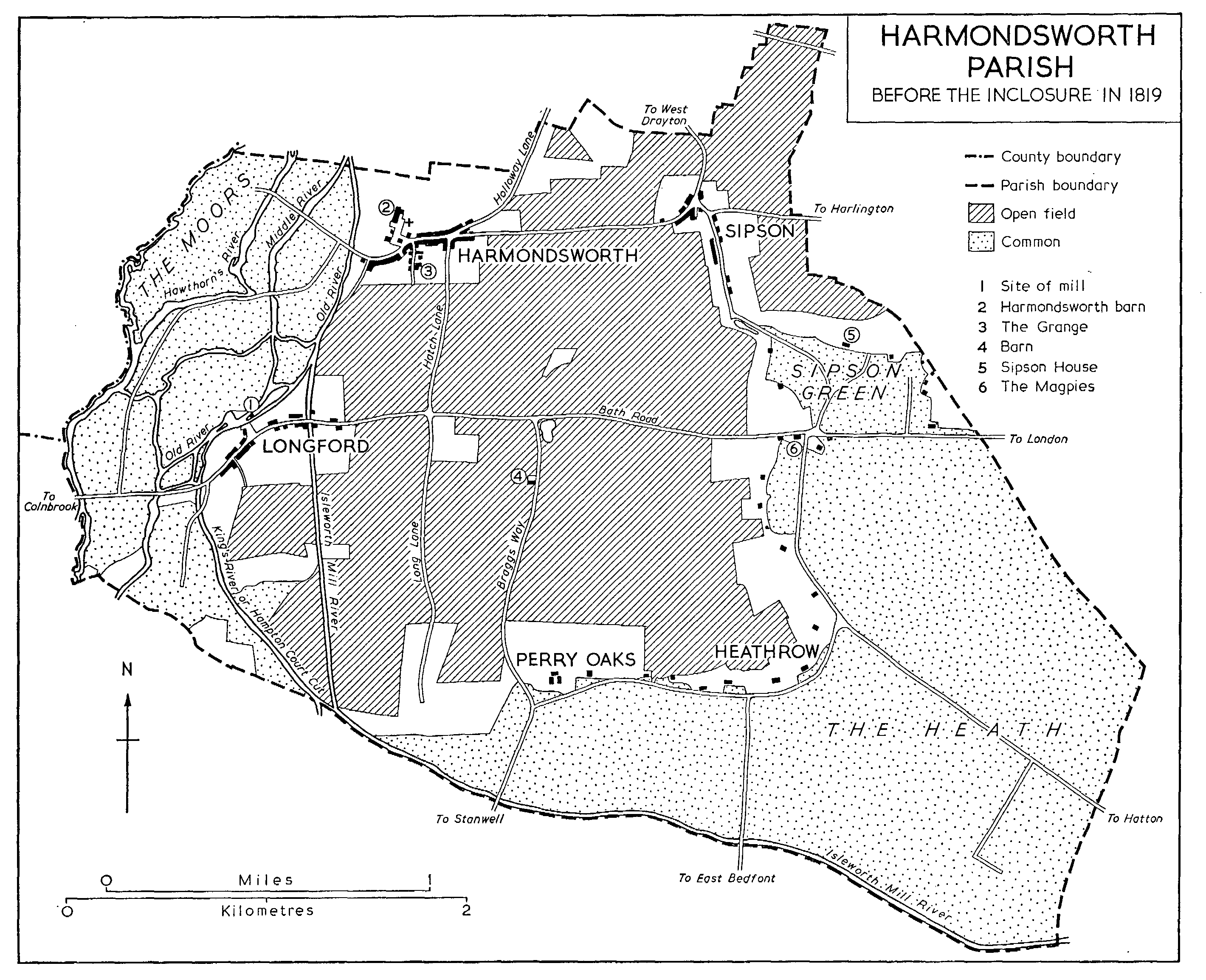
The first definite picture of the parish is supplied by Rocque's map of 1754, where the settlement pattern is clearly shown. At Longford, Harmondsworth, and Sipson there were small, compact groups of houses. At Longford they lined both sides of the Bath Road from the east bank of the Longford River up to and across the Duke of Northumberland's River. Harmondsworth was mainly grouped south and west of the church and along the south side of Moor Lane. Hatch Lane led south to the Bath Road, and continued south to Perry Oaks as Long Lane; Holloway Lane led north to West Drayton; while Harmondsworth Lane, running east to Sipson, and continuing to Harlington as Sipson Lane, was only a track across the open fields. The main settlement at Sipson lay south of Harmondsworth Lane, and was grouped on both sides of Sipson Road; a few houses were situated at Sipson Green where the road joined the Bath Road. From the Bath Road at King's Arbour to its southernmost point dwellings, collectively known as Heathrow, lined the side of Heathrow Road. At the south end two tracks left the road and ran over the heath, one southward to Bedfont and the other east to Hatton. Another track to Hatton ran south-east from King's Arbour. Perry Oaks consisted of one house. From it the later Oaks Road led south to Stanwell and another road south-west to Stanwell Moor. Heathrow Road itself turned north to the Bath Road again as Tithe Barn Lane.
In 1754 the greater part of the parish was open. Around all the settlements were inclosed lands, but there appears to have been none elsewhere. The uncultivated area west of the rivers was known as Harmondsworth moors, although south of the Bath Road the area between the Colne and the Longford rivers was meadowland, and between the Longford and the Duke's rivers arable. Arable covered the rest of the parish to the eastern boundary north of the Bath Road and to Heathrow Road in the south. Harmondsworth Field lay north of the Bath Road and south of Harmondsworth Lane, while Sipson Field covered the area north of Harmondsworth and Sipson lanes. Heathrow Field lay south of the main road and behind Heathrow. Hounslow Heath covered the area south and west of Heathrow. In 1754, therefore, both ends of the parish consisted of uncultivated moor or heath, while the central portion, ringed with settlements and a belt of inclosed land, formed the cultivated area. (fn. 54)
Between 1754 and the Parliamentary inclosure of 1819 inclosure increased, mainly in the north- and south-west, and settlement spread between Heathrow and Perry Oaks, although still on the northern side of the road. (fn. 55) At inclosure few of the roads were altered. Harmondsworth and Sipson lanes were both made along the old tracks. Long Lane, then called Lord Lane, was made a private road, and other private roads continued from Moor Lane in Harmondsworth over the moors. Cain's Lane was laid out over the heath but ran south-east to Bedfont, and not east as it had previously done. High Tree Lane was made approximately along the old track to Bedfont, but the track from King's Arbour over the heath disappeared. At this date most of the fields can be identified, (fn. 56) although the Perry fields, which existed both in the 17th century (fn. 57) and in 1839, (fn. 58) were not mentioned. Apart from Harmondsworth, Sipson, and Heathrow fields, the older fields and meadows appear to be Little Field, (fn. 59) Wide Mead, (fn. 60) and Bury Mead. (fn. 61) A Southcote Field is mentioned in 1431, (fn. 62) and an Oldfield in Heathrow in 1597, (fn. 63) but these cannot now be identified.
By 1839 the cultivated area of the parish had been considerably extended. Over 770 a. of former heath and moorland had been brought under cultivation, although the extreme western end of the parish was still rough pasture. There were also almost 30 small orchards scattered across the parish. In Harmondsworth village, cottages had extended over the Colne, and there were also a few houses near Mad Bridge. Sipson Green, lying on both sides of the Bath Road, was almost as large as Sipson itself, but both Sipson Green and Sipson were smaller than Harmondsworth (the largest village), Longford, and Heathrow. There were village shops at Harmondsworth, Longford, and Sipson, but Heathrow had only a public house. (fn. 64)
During the 19th and early 20th centuries the parish was comparatively little built upon. By 1900 houses in Harmondsworth extended down Hatch Lane on both sides of the road and buildings behind Moor Lane had been erected. In Sipson houses had been built along Sipson Lane, Sipson Road, and Harmondsworth Lane, while a few dwellings were erected at Sipson Green. A few houses were built along Heathrow Road and Cain's Lane but this area remained largely rural until the Second World War. After 1850, however, arable land in the parish diminished and extensive orchards were planted. These lay mainly on the periphery of the parish, on the moors, surrounding Sipson and Sipson Green, in Cain's Lane, and surrounding Perry Oaks. The centre remained arable. There were also several glasshouses at Sipson. (fn. 65)
The character of the parish started to change gradually in 1929 with the opening of the Colnbrook by-pass, which left the Bath Road at the junction with Hatch Lane and by-passed Longford to the north. Industrial development began in 1930 with the opening of the Road Research Laboratory on the Colnbrook by-pass. In the same year the Fairey Aviation Co. opened an airfield, the Great West Aerodrome, south-west of Heathrow. This formed the nucleus of the later airport, (fn. 66) and the Fairey hangar was eventually incorporated into Heathrow Airport as a fire station. By the late 1930s some residential building had taken place, although almost entirely in the northern half of the parish. Small estates were built off Hatch Lane around Candover Close and Zealand Avenue and further building took place along Sipson Road, around Blunts Avenue, and along the north side of the Bath Road at Sipson Green. Longford remained virtually untouched. A brick-works was established by the corner of Cain's Lane and Heathrow Road and the area of former heathland was extensively worked for gravel, sand, and grit. The county council also opened a large sewage pumping station to the west of Perry Oaks. The Great South West Road from Brentford to Staines also crossed the south-east corner of the parish but played no part in its development. Although many of the orchards survived, their numbers had been greatly reduced and it seems probable that much of the former fruit-growing area was being used for market gardening. (fn. 67) In 1944 Harmondsworth and Sipson retained their agricultural character despite some suburban housing. It was then suggested that further expansion in the Yiewsley and West Drayton area should be curtailed, as the land was primarily in demand for agriculture; (fn. 68) this proposal has largely been followed.
In 1944, however, the modern pattern of Harmondsworth began to emerge with the transfer of the Fairey airfield to the Royal Air Force and its subsequent development by the Air Ministry as Heathrow R.A.F. station. This entailed the complete demolition of Heathrow and Perry Oaks hamlets, and widespread draining of the old flooded gravel pits. Many of the small buildings along the south side of the Bath Road that were still standing in 1960 were erected by the R.A.F. Although R.A.F. personnel were using the airfield in 1944-5, the construction of the base's three runways had not been completed by 1945. (fn. 69) The end of the Second World War left the R.A.F. with no need of a long-haul transport airfield, (fn. 70) and it was proposed that the station should be converted into an international civil airport. In 1946 Heathrow Airport came officially into being and was transferred to the Ministry of Civil Aviation; regular services started in January 1946, (fn. 71) and civil flights from Northolt were transferred to Heathrow after 1952. (fn. 72) A plan to extend the airport by building three runways on the north side of the Bath Road, in addition to the six under construction in the main part of the airport (fn. 73) was, however, abandoned. The expansion of the airport during the late 1940s entailed road and river diversions. Heathrow Road, Cain's Lane, High Tree Road, and Oaks Road were all destroyed. Long Lane was diverted slightly but in 1960 still existed as a private road for airport use and as an approach to the sewage works. In place of these roads the ministry constructed Stanwell New Road between 1947 and 1949. This runs south to Stanwell and Staines from the Bath Road between Moor and King's bridges. During construction of the runway the sewage works were moved north, and both the Duke of Northumberland's and the Longford rivers diverted to run southward in one channel. In 1960 most of the airport's 2,850 a. lay in Harmondsworth. The area in the parish included runways 1 to 7 laid out in the form of a star of David, the central terminal buildings designed by Frederick Gibberd, the north terminal buildings, the southern air-traffic control centre, and the large maintenance base of British European Airways. (fn. 74) The M 4 motorway from London to the west, opened in 1964, cuts through the northernmost tip of Harmondsworth parish before entering West Drayton. A branch road to the south, passing east of Sipson and beneath Sipson Lane, Sipson Road and the Bath Road, links the motorway with the airport. North of the airport and the Bath Road the appearance of the parish has otherwise changed little. Flat and hedgeless, its fields lay open, and in the west by the rivers it remained rough pasture.
Apart from the church (fn. 75) and the barn, (fn. 76) the two most notable buildings in Harmondsworth village are in Summerhouse Lane. The Grange is a twostory brick house, with a hipped, tiled roof, and windows mostly two-light and transomed. It was built in 1675 and in the south wall there is a painted sundial dated 1695. Harmondsworth Hall, opposite the Grange, was reconstructed in the 18th century but incorporates a 17th-century chimney. (fn. 77) At the west end of the village street, where the road widens to form a small green, the Sun House, a timberframed range probably dating from the 16th century, was remodelled in the 18th century. (fn. 78) The Lodge, an imposing early 19th-century residence at the far end of the street, stood derelict in 1968, by which time the 16th-century Centre House in Holloway Lane had already been demolished.
At the west end of Longford, Weekly House, on the south side of the Bath Road, dates from c. 1700, and Longford Close, opposite, from the late 18th century. In the middle of the village a restored timber-framed house with cross-wings, dating from the 16th century, faces the White Horse Inn, and in a lane leading to the river a range of 1739 had recently been renovated as two houses in 1968. Further east a group of timber-framed buildings includes Longford Cottage and the house now called the Stables, both much restored. Sipson House, dating from the late 18th century, stands near the south end of Sipson Lane opposite the main entrance to London Airport. (fn. 79)
Nothing is known of the inns of the parish before the mid 18th century. In 1748 there were nine inns (fn. 80) of which the 'Magpies', the 'King's Head', and the 'White Horse' became the best known. The 'Magpies', later called the 'Old Magpies', stood at the corner of Heathrow Road and the Bath Road. The house, built in the 16th century and later much altered, (fn. 81) was demolished in the 1950s. A few yards up the road was another inn called the 'Three Magpies', which may be that known in 1765 as the 'Three Pigeons' and later as the 'Magpie and Pigeon'. (fn. 82) This 18th-century house was still standing in 1960. In Harmondsworth village the Five Bells, 17th-century but refaced with brick, looks eastward down the main street from the green. At Longford the 'White Horse', dating from the 17th century, is much restored. The 'King's Head' at Longford originally stood just east of the Duke's River on the north side of the Bath Road. It acquired its later name of the 'Peggy Bedford' from the family of licensees who are first found at the 'King's Head' in 1775, (fn. 83) and were still there in 1824. (fn. 84) It is said that Peggy Bedford herself died in 1859 and that the inn was burned down later in the century. (fn. 85) It was rebuilt on its present corner site on the Colnbrook by-pass and the Bath Road in the 1930s.
The Domesday Survey mentions 44 people on the monastic estate in Harmondsworth, and two villeins on a further hide, which belonged to Colham manor. (fn. 86) In the mid 12th century there were said to be 86 people in the parish, (fn. 87) and in the 1330s 43 men were listed on a muster roll. (fn. 88) By 1337 the manor of Harmondsworth had 16 tenants in Ruislip. (fn. 89) In 1530 there was an increase, probably temporary, of 42 labourers who were working on the new river cut from Longford, (fn. 90) and in 1547 there were 245 communicants in the parish. (fn. 91) In 1642 143 adult males took or failed to take the protestation oath, (fn. 92) and 107 people were assessed to the hearth tax in 1664. (fn. 93) Twelve years later there were said to be 200 conformists and 48 nonconformists in the parish. (fn. 94) In 1801 the population was 879. From that date it has risen fairly steadily; the numbers appear stationary between 1841 and 1861, and the increase is again slow between 1881 and 1901. The largest single increase came during the decade from 1921 to 1931 when the population rose from 2,288 to 3,084. There were 3,365 people resident in the parish in 1951 and 3,321 in 1961. (fn. 95)
HARMONDSWORTH PARISH
Before the inclosure in 1819
Few famous people have been associated with the parish. General Sir John Byng, who fought throughout the Peninsular War and at Waterloo, was in 1835 created Baron Strafford of Harmondsworth and later Earl of Strafford. William Heather, a late-16thcentury musician, founder of the professorship of music in the University of Oxford, was born at Harmondsworth about 1563. (fn. 96)