A History of the County of Middlesex: Volume 7, Acton, Chiswick, Ealing and Brentford, West Twyford, Willesden. Originally published by Victoria County History, London, 1982.
This free content was digitised by double rekeying. All rights reserved.
Diane K Bolton, Patricia E C Croot, M A Hicks, 'Chiswick: Growth', in A History of the County of Middlesex: Volume 7, Acton, Chiswick, Ealing and Brentford, West Twyford, Willesden, ed. T F T Baker, C R Elrington (London, 1982), British History Online https://www.british-history.ac.uk/vch/middx/vol7/pp54-68 [accessed 30 April 2025].
Diane K Bolton, Patricia E C Croot, M A Hicks, 'Chiswick: Growth', in A History of the County of Middlesex: Volume 7, Acton, Chiswick, Ealing and Brentford, West Twyford, Willesden. Edited by T F T Baker, C R Elrington (London, 1982), British History Online, accessed April 30, 2025, https://www.british-history.ac.uk/vch/middx/vol7/pp54-68.
Diane K Bolton, Patricia E C Croot, M A Hicks. "Chiswick: Growth". A History of the County of Middlesex: Volume 7, Acton, Chiswick, Ealing and Brentford, West Twyford, Willesden. Ed. T F T Baker, C R Elrington (London, 1982), British History Online. Web. 30 April 2025. https://www.british-history.ac.uk/vch/middx/vol7/pp54-68.
GROWTH.
Articles dating from Mesolithic to Roman times have been found in the Thames, and a Roman presence is attested by coins, notably from an urn dug up at Turnham Green in 1731 and by brickwork beneath the manor house of Sutton. (fn. 1) The name Chiswick, 'cheese farm' or wic, occurs c. 1000, (fn. 2) when probably the whole parish formed part of the estates of St. Paul's. (fn. 3) Most early references, however, are to Sutton, which became the chief manor and denoted the 'south farm' or tun, probably in relation to Acton. (fn. 4) While the manor house of Sutton occupied a fairly central position, the hamlet, called Little Sutton by 1589, (fn. 5) remained insignificant in size compared with Old Chiswick, Turnham Green, and Strand-on-the-Green.
Chiswick and Strand-on-the-Green were riverain settlements, on gravel: Strand was a 'shore' or 'quay' and Turnham Green, which grew up farther north along the high road, possibly denoted a homestead by a turn or bend in the river. (fn. 6) The Thames has played a crucial role, symbolized in the church's dedication by 1458 to St. Nicholas, the patron saint of fishermen. (fn. 7) Both Chiswick and Strand-on-the-Green had ferries. Fishing, water traffic, and boat building were the chief occupations, before the river attracted workshops. The danger of flooding over fields in the peninsular part of the parish, which were too flat for easy drainage, kept them free from housing until the 20th century. In contrast the charm and accessibility of the riverside attracted wealthy residents, not only during the period when Chiswick could benefit from the royal family's nearby residence on the Surrey bank, at Kew.
'Chiswick town' (Old Chiswick), Turnham Green, and Strand-on-the-Green served as divisions, for the purpose of listing inhabitants, by 1590. (fn. 8) They also formed divisions for manorial and parochial government, occasionally with smaller districts added, from the 17th until the 19th century. (fn. 9) Their individual histories, with those of Little Sutton and of more recent but clearly defined suburbs, are given below.
The parish's main settlements, lying near its edges, were separated until the 19th century by fields, gardens, and parkland. Forerunners of the existing Chiswick House, which was created by the earl of Burlington (d. 1753) and enlarged by his Cavendish heirs, the dukes of Devonshire, lay between Chiswick village and, to the northwest, Little Sutton and Turnham Green. In 1979, after much intervening building had taken place, Old Chiswick and Strand-on-the-Green remained as accessible from Hammersmith and Brentford respectively as from each other, or even from Turnham Green.
In 1547 there were 120 houseling people in the parish (fn. 10) and in 1664 there were 230 houses, as many as 107 of them too poor to be assessed for hearth tax. (fn. 11) Of 167 ratepayers on the church roll in 1630, 75 lived in 'Chiswick town', 50 at Turnham Green, 31 at Strand-on-the-Green, and 11 at Little Sutton. (fn. 12) Numbers were similarly distributed in 1678, (fn. 13) although by 1706 the topographer John Bowack (fn. 14) considered that Turnham Green looked as big as Old Chiswick. (fn. 15) In 1795 the total population was thought to have doubled between 1680 and 1780 but not to have risen thereafter. (fn. 16) The balance so changed that Turnham Green had 296 families by 1801, while Old Chiswick had 201, Strand-on-the-Green 123, and Little Sutton 17. (fn. 17)
The parish had offered a country retreat for Henry VI and later for prelates in the 15th century and for courtiers and the scholars of Westminster from the 16th. (fn. 18) By 1706 its 'sweet air and situation' had brought it many noble seats, (fn. 19) although it was after the building of Chiswick House that it became most popular. The Cavendishes not only entertained the great, as their own guests, (fn. 20) but attracted sightseers: Horace Walpole in 1781 defended the duke's practice of admitting visitors only by ticket, as had been done for the past 30 years. (fn. 21) By 1779, when Strand-on-the-Green was becoming fashionable like Old Chiswick and Turnham Green, land values had so risen that ½ a. not worth £5, presumably for agriculture, had been sold for £2,000. The vestry then revised its system of rate assessment, in order that local advantages should continue to 'lead gentlemen of expanded minds into extraordinary expenses to gratify their inclinations.' (fn. 22)
Old Chiswick was in 1980 the accepted name of Chiswick village, itself recorded c. 1000 (fn. 23) and so perhaps named earlier than Sutton, of which it was once thought to have been an outlying hamlet. (fn. 24) From the early 17th to the 19th centuries it was known as Chiswick town or simply as 'the town'. The description, besides emphasizing that it was the main village, perhaps served to distinguish its more elegant part from a cluster of riverside cottages known by 1723-4 as Sluts Hole (in 1865 Fisherman's Corner). Inhabitants of Sluts Hole were often listed separately in 18thcentury rate assessments, although their cottages, south of the church, formed the western end of the main village. (fn. 25)
The settlement apparently grew up immediately east of the church, mentioned in 1181, and away from the river. (fn. 26) Church Street there ran northward from the ferry, with a continuation across the open field which lay between the village and the high road to London and Brentford. A little to the east of Church Street and close to the river stood a stone building of c. 1100, the oldest known part of the prebendal manor house (later College House). (fn. 27) Presumably that building and its neighbours were reached by a way leading eastward from the ferry along the river bank, the forerunner of Chiswick Mall, although it is not clear how far the medieval road extended.
Londoners whose families presumably came from Chiswick included Geoffrey of Chiswick, recorded from 1247 (fn. 28) and a landowner in Kent by 1264, and his contemporary Walter of Chiswick, followed by Robert, son of Gilbert of Chiswick, recorded in 1308. (fn. 29) Property in Chiswick village or parish was acquired by Londoners from the mid 15th century or earlier. (fn. 30) Henry VI's visits to Sutton may have brought some distinguished residents: (fn. 31) the chancellor Robert Stillington, bishop of Bath and Wells (d. 1491) (fn. 32) probably lived in the village, where in 1470 his 'hospice' had a great chamber by the Thames. (fn. 33) Another Robert Stillington was a feoffee of property in Chiswick, including the 'Counterhouse', in 1495. (fn. 34)
In the late 16th and early 17th centuries the grandest residents lived on the outskirts of the village: the Russells at Corney House to the west, and the Wardours, the earl of Somerset and their successors in a forerunner of Chiswick House, to the north. (fn. 35) What was later Chiswick Mall, however, contained the vicarage house at the bottom of Church Street by 1589-90 (fn. 36) besides the old prebendal manor house, enlarged c. 1570 for Westminster school, (fn. 37) and a substantial forerunner of Walpole House. (fn. 38) They probably stood near other imposing houses, afterwards rebuilt, since in 1706 Bowack noted the interior decoration of some 'very ancient' dwellings by the river. (fn. 39) In Church Street the later Burlington Arms, so called by 1751, existed in the early 16th century. (fn. 40)
The use of Chiswick as a scholars' retreat helped to advertise its healthy reputation. Sir Edward Wardour, having moved to the smaller Turret House, claimed c. 1637 that he merely retired there during the summer vacation. (fn. 41) The village was considered royalist in 1642, when parliamentary troops came to burn the altar rails from the church but were prevented from pillaging the prebendal manor house, held by Arthur Duck, and a house belonging to the earl of Portland. (fn. 42)
A branch of the Russell family lived on the site of the existing Bedford House from c. 1664 (fn. 43) but their house, like others of the 17th century, was later rebuilt. In 1706 the town, although small, was thought to be pleasantly situated and to have long contained more noblemen among its residents than any of its neighbours. Most of the houses formed a ribbon along the riverfront, stretching from the church to the parish boundary, and there were handsome buildings in Church Street. Several small traders, and many more fishermen or watermen, also lived close to the Thames. (fn. 44) Presumably most were at Sluts Hole, although the line of riverside buildings east of the vicarage was not entirely devoted to rich residents: Thomas Mawson had opened his brewery behind the houses half way along the row, near the foot of Chiswick Lane, c. 1700 (fn. 45) and the brewery's Red Lion, perhaps the only inn facing the river, had been licensed by 1722. (fn. 46) The inn stood close to a draw dock, where barges were still unloaded in the late 19th century. (fn. 47)
In 1746 Old Chiswick was still mainly a riverside village, extending eastward along the gravel into Hammersmith but no farther west than Corney House, beyond which lay marshes. Church Street ran a short way inland before turning left to meet Burlington Lane, and from the churchyard a narrow way, in 1752 called Paul's Walk (fn. 48) and later Powell's Walk, provided a north-westerly short cut to the lane and Chiswick House. Roads radiated from north of the junction of Church Street with Burlington Lane, near the modern Hogarth roundabout: Chiswick Field Lane led straight to the high road, while a forerunner of Hogarth Lane led north-westward to Turnham Green, and Mawson Lane led north-eastward to meet Chiswick Lane by the brewery. Parallel with Chiswick Field Lane, Chiswick Lane led to the high road from half way along the river front, as did a forerunner of British Grove from behind its eastern end, where it joined a lane which ran behind the riverside houses from Church Street into Hammersmith. Away from the river houses lined both sides of Church Street to the point where it met Burlington Lane, a little beyond which they formed Chiswick Square. Buildings also stretched up Chiswick Lane to the corner of Mawson Lane, which ran south-west to Church Street. A few detached houses, one of them soon to be taken by William Hogarth, stood at the Old Chiswick end of the road across the common field to Turnham Green. (fn. 49)
Surviving houses recall the wealth of 18thcentury residents. (fn. 50) So, from c. 1750, do views of the village, where there were many more large houses than on the waterfront at Strand-on-theGreen, although artists often preferred to show the fishermen's cottages huddled between the foreshore and the church. (fn. 51) The built up riverside had an almost urban appearance, although the name Mall, as in Hammersmith, was perhaps not adopted until the early 19th century in an attempt to suggest that the district was as fashionable as Westminster's Pall Mall.
Despite much rebuilding, the village spread very little between the mid 18th and late 19th centuries. By 1801, with 1,023 inhabitants in 172 houses, it was less populous than Turnham Green, (fn. 52) which by 1839 had the greater number of inns. (fn. 53) Chiswick Mall contained a few tall trees on a grassy verge between the road and the river in 1827. (fn. 54) Its houses retained large back gardens in the 1860s, when they also had their existing plots along the riverside verge. There was still open country, owned by the duke of Devonshire, west of the churchyard, besides the estate of the Prebend manor, including Home field, to the north. More houses stood at the south end of Hogarth Lane, beyond the village, and in Burlington Lane the Cedars, from c. 1863 the home of the landscape painter Henry Dawson (1811-78), (fn. 55) faced Corney Lodge at the end of Powell's Walk. (fn. 56) Changes in the village itself arose mainly from industry: the Griffin brewery had expanded beside Chiswick Lane, the Lamb brewery had grown up off Church Street, and the cottages below the church were about to make way for the workshops of Thornycroft & Co., the shipbuilders. (fn. 57)
The late 19th century saw the village joined by housing both to the suburbs along the high road and to the western districts of Hammersmith. Its declining importance as a centre of parish life, already foreshadowed by the opening of churches and schools at Turnham Green and Chiswick New Town, was accelerated by its remoteness from the railways and by the rise of new suburbs, with their own services. (fn. 58) Old Chiswick thus became a residential backwater, varied by some thriving industry. It lost its most ancient buildings, with the demolition of College House and the reconstruction of the church, but expensive houses were still put up in Chiswick Mall. (fn. 59)
The departure of Thornycrofts, completed by 1909, perhaps secured the village's future as a residential area. An alleged source of pollution had gone, (fn. 60) although smaller firms moved in and extended their wharves and depots to the southwest. Church Street had several shops c. 1910, (fn. 61) in contrast with the more stately Chiswick Mall, where the Red Lion lost its licence c. 1915. (fn. 62) The closure of the Lamb brewery, in the period between the conversion of Church Street's two inns to private use, left only the Griffin as a major employer near the river. North of the village, however, the Chiswick Polish Co. and its successors gradually expanded in the angle between Burlington Lane and Hogarth Lane. (fn. 63)
The north corner of Church Street was demolished in the 1930s, when part of Burlington Lane became Great Chertsey Road, and further demolitions accompanied work on Hogarth Lane and Mawson Lane in the 1950s. (fn. 64) Heavy traffic along the widened roads helped to cut off the old village from the suburbs inland.
There have been few changes in Chiswick Mall since the First World War, apart from the rebuilding in 1936 of a hospital which had opened at Rothbury House (fn. 65) and, c. 1968, the construction near by of town houses called Miller's Court on the site of a bakery close to the Hammersmith boundary. (fn. 66) Cottages in the churchyard were pulled down in the 1930s, followed by the former schoolroom in 1951, (fn. 67) and new warehouses were built on Thornycrofts' former yard at Church wharf. (fn. 68) Old Chiswick, including Chiswick Eyot, was declared a conservation area under the Civic Amenities Act in 1969. (fn. 69) Its residential character was soon afterwards emphasized by controversial plans to replace the warehouses at Church wharf with private flats or houses, none of which had been built by 1980. (fn. 70)
Notable inhabitants (fn. 71) not mentioned elsewhere in the article included the French born ambassador Sir Stephen Lesieur (fl. 1586- c. 1637), assessed from 1628 until 1637, (fn. 72) Leonard Mawe, bishop of Bath and Wells, who died at Chiswick in 1629, and the physician and poet Edward Baynard (b. 1641, fl. 1719), who was often there at the time of the plague in 1665. Sir Crisp Gascoyne (1700-61), lord mayor of London, and Charles Holland (1733-69), actor and son of a local baker, were both born at Chiswick. The painter Edward Penny (1714-91) died there, as did the engraver William Sharp (1749-1824), and the Anglo-Saxon scholar Benjamin Thorpe (1782-1870), a resident of Chiswick Mall. The German born painter Philip James de Loutherbourgh (1740-1812), although buried in Chiswick, lived across the boundary in Hammersmith Terrace. Jean-Jacques Rousseau lodged with a grocer named Pulleyn in Old Chiswick in 1766. (fn. 73)
Old Chiswick's main architectural distinction (fn. 74) lies in the 18th- and 19th-century residences, mainly of brown brick, which stretch along Chiswick Mall. Approached from the east, the first houses beyond Miller's Court are Cedar House, formerly Eyot Cottage, and Swan House, probably late 17th-century but largely refaced. Next to them stand Island House and Norfolk House, a taller and more elaborate pair of the early 19th century, and St. John's House of c. 1800, all three of them stuccoed. Beyond some modern buildings is the Oziers, an early 19thcentury refacing of an older house, and a distinguished group formed by Morton House, Strawberry House, and Walpole House, all of brown brick with red-brick dressings. Both Morton House and Strawberry House were built c. 1700 and refronted c. 1730, the second having a late 18th-century cast iron porch on slender fluted columns. Walpole House, perhaps the finest in the row, has internal features of the 16th and 17th century, with a garden front of c. 1700, and a river front and north-west extension of c. 1730. It is said to have been the last home of Charles II's former mistress Barbara Villiers, duchess of Cleveland (1641-1709), who was buried in Chiswick church, (fn. 75) and to have supplied a lodging for the politician Daniel O'Connell (1775-1847) as a law student c. 1796. Later it was also a school, attended and made famous by Thackeray, (fn. 76) and in 1908 it was the home of the actor-manager Sir Herbert Beerbohm Tree (1853-1917). (fn. 77)
Beyond Walpole House some later buildings include the Tides and Orford House, a pair designed in 1887 by J. Belcher. Near the entrance to Eyot Green, a modern cul-de-sac, is Greenash, designed by Belcher in 1882 in the style of Norman Shaw and, as Eyot Villa, the home until c. 1912 of the engineer Sir John Isaac Thornycroft. (fn. 78) On the west corner of Chiswick Lane part of the Griffin brewery borders Chiswick Mall for a short way, next to the old Red Lion inn. The former inn, called Red Lion House, is of c. 1700, afterwards stuccoed and given an attic. Close by are the early 19th-century Chiswick Mall Cottages. Lingard House and Thames View were built as a single house c. 1700. Said House is 19th-century and looks earlier because of a modern reconstruction.
Set back from the west end of Chiswick Mall are Eynham House and Bedford House, presumably successors of Edward Russell's building of the 1660s. Russell's house was bought by Thomas Plukenett and passed by marriage to the Woodroffes, who retained it until 1920. It then became the home of the local historian Warwick Draper (d. 1926) (fn. 79) and later of the actor Sir Michael Redgrave, who sold it in 1956. (fn. 80) The houses, originally one and with a shared pediment, are early 18th-century, but Bedford House has a south-western extension dated 1749 and both have later wings. The walled garden contains a mid 18th-century Gothic gazebo and lead cisterns dated 1622 and 1678. The neighbouring Woodroffe House is a severe building of c. 1700, with later windows, standing east of the Old Vicarage on the corner of Church Street.
On the east side of Church Street, truncated and in 1980 almost entirely residential, the sidewall of the Old Vicarage and the late 18thcentury Vine House stand opposite the church. Next to Vine House is Chiswick's oldest surviving house, timber-framed and probably early 16th-century, formed out of three tenements which themselves once served as the Burlington Arms. The building is of whitewashed rubble and stucco, with exposed half timbering on the projecting upper storey; it has been much altered but retains some internal and external 17thcentury plasterwork. The neighbouring Burlington Corner, of weatherboarded timber framing but with modern additions at both back and front, has reset early 16th- and mid 17thcentury panelling. Beyond some converted offices by the old entrance to Lamb's brewery stands the early 18th-century Wistaria, of red brick. On the west side of the street, opposite Burlington Corner, is an early 18th-century building of brown brick with red-brick dressings, which has been divided into Holly House and Latimer House; it has later two-storeyed wings, and a wrought iron gate and screen.
Almost on the corner of Church street and Burlington Lane, an alley leads to Page's Yard, where there is a row of four 18th-century brick cottages. (fn. 81) Off Burlington Lane itself the late 17th-century Chiswick Square serves as a forecourt to Boston House, with a two-storeyed pair on the west side and a three-storeyed house on the east, all of brown brick with red dressings. Boston House itself, on the south side, is said to derive its name from Viscount Boston, a title borne by Henry d'Auverquerque, earl of Grantham (d. 1754). After the earl's move to Grove House c. 1750, Boston House passed to Lord Archibald Hamilton and to Hamilton's son-in-law Francis Greville, Earl Brooke and afterwards earl of Warwick (d. 1773). It later became a girls' school before belonging to Henry Stratton Bates from 1869 to 1889, to trustees for St. Veronica's retreat, and in 1922 to the Chiswick Products Co. and its successors, (fn. 82) which in 1980 used it mainly for staff recreation and storage. (fn. 83) The house was originally built on a half H-shaped plan but received a large early 18th-century addition to the south-west and later extensions at either end.
Modern building has left only Hogarth's 'little country box' to recall the 18th-century spread of housing from Chiswick village along Hogarth Lane. (fn. 84) A brick house with 60 rods of garden was held of the Prebend manor in 1728 by the Revd. George Andrew Ruperti, whose son George conveyed it in 1749 to the painter William Hogarth (1697-1764). (fn. 85) Although Hogarth himself died at his London house, both his mother-in-law, the widow of Sir James Thornhill, (fn. 86) and his own widow Jane died at Chiswick. Jane Hogarth was followed in 1791 by her cousin Mary Lewis, from whom the house passed in 1810 to Richard Loveday, in 1814 (fn. 87) to the Revd. Francis Cary (1772-1844), the translator. (fn. 88) Much decayed by 1874, it was saved in 1891 by Alfred Dawson and again, after the failure of a public appeal, in 1902 by Lt. Col. Shipway of Grove House, who furnished it and gave it in 1907 to the county council as a Hogarth museum. After bomb damage in 1940 the museum was reopened in 1951 and taken over by Hounslow L.B. in 1965.
Hogarth's house is late 17th-century, with a low early 18th-century addition to the south. The house and its walled garden, with a mulberry tree of Hogarth's time, offer a peaceful contrast with the modern warehouses of Reckitt and Colman and heavy traffic along the lane which has become the Great West Road.
Farther east, the Great West Road has replaced Mawson Lane, named after the family which established the Griffin brewery. The Mawsons also gave their name to a terrace running south from Mawson Lane's junction with Chiswick Lane, backing on the brewery and known as Mawson Row. The corner house (no. 110 Chiswick Lane) was reputedly the home of Alexander Pope, a protégé of Lord Burlington, and his family from 1716 to 1719; later it was an inn, called in turn the Mawson Arms and the Fox and Hounds. (fn. 89) The inn is early 18th-century, like its neighbours (nos. 112-18, even), but has some later windows. Farther south is another brick range of the 18th century (nos. 130-4, even), with stucco refronting on the ground floor.
Turnham Green probably gave its name to Stephen of Turnham, who occurred in 1199, (fn. 90) and was itself recorded as 'the field of Turnham' between 1229 and 1237. (fn. 91) It did not grow up around a church or manor house but as a result of traffic along the high road from London to Brentford. The area described below is not merely the one around the existing common called Turnham Green but that of all the straggling settlement along Chiswick High Road, from the Hammersmith boundary to Gunnersbury.
In 1590 Turnham Green common was the name of waste land of Sutton Court manor along the high road, west of the prebendal manor. (fn. 92) Among early inns was the King of Bohemia, perhaps named after the father of Prince Rupert and mentioned in 1632. (fn. 93) Although Turnham Green had fewer ratepayers than Old Chiswick in the 17th century, there were substantial houses by 1664, when those of Lady Wortley and Lady Margaret Cholmley contained 24 and 22 hearths respectively and when the first, with College House, was assessed as the fourth largest in the parish. (fn. 94) Lady Wortley was presumably the widow of Sir Edward Wortley, who had paid rates from 1649, and a Sydney Wortley was still at Turnham Green in 1683. The Whittaker family, represented from c. 1636 to 1658 by Laurence Whittaker, (fn. 95) was living there by 1624 and had given its name (fn. 96) to a field north of the high road by 1649. (fn. 97) Viscount Shannon was a resident by 1664, as were his wife in 1678 and Lord Paston, afterwards earl of Yarmouth, who married Charlotte, Lady Shannon's daughter by Charles II, from c. 1681 to 1685. (fn. 98) A house which had belonged to Charlotte's first husband James Howard (d. 1669) was reputedly the later Bolton House, occupied by the traveller Sir John Chardin (1643-1712) (fn. 99) in 1705, when its gardens were admired by Evelyn. (fn. 100) The earl of Devonshire in 1691 occupied Arlington Garden, presumably at the west end of Turnham Green common, where in 1746 there was a seat with formal gardens (fn. 101) and later one known as Arlington House. Other residents included the divine and playwright Henry Killigrew (1613-1700) in 1669, (fn. 102) the marquess of Worcester in 1672, Sir Miles Cooke in 1678, Sir John Pye, Bt., c. 1678 to c. 1685, (fn. 103) and Lady Lort. (fn. 104)
Turnham Green was thus a fashionable locality by c. 1677, when there was settlement along the south side of the high road, near the Hammersmith end. (fn. 105) By 1706 the village, with 'several good brick houses', was comparable in size to that of Chiswick (fn. 106) and by 1720 there were buildings on both sides of the high road. (fn. 107) Convenient for travel from London to the palaces at Windsor and Hampton Court and later at Kew, Turnham Green may already have been noted as a healthy place: in 1733 Sir Thomas Robinson, Bt., took lodgings there for his wife's convalescence, (fn. 108) and in the early 19th century it was thought to be well sheltered to the north by the rising ground of Ealing and Acton. (fn. 109) Besides the parish workhouse built north of the road in 1725, there were well known inns by the mid 18th century, at one of which assemblies were held. (fn. 110) With gaps on the north side opposite Devonshire Road and on the south side east of Chiswick Lane, detached buildings then intermittently lined the high road from the Hammersmith boundary to the crossroads with Acton Lane and Sutton Lane, dividing the Back or Chiswick common from Turnham Green common. Few houses stood away from the high road, except at its junction with Acton Lane and Sutton Lane, west of which stretched open country as far as London Stile. Heathfield House and some neighbouring buildings formed a group at the south-west corner of Turnham Green common, reached by Sutton Lane. (fn. 111) In the extreme north-east corner of the parish, a few inhabitants were assessed separately in the 1630s as being at Stamford Lane, and sometimes in the 18th century as at Stamford Brook. The locality, with only 4 houses in 1795, was at other times probably considered part of Turnham Green. (fn. 112)
In the late 18th century noble residents included the countess of Stafford and the marquess of Annandale, who died in 1783 and 1792 respectively, (fn. 113) besides the occupiers of Heathfield House. (fn. 114) By 1801 Turnham Green was larger than Old Chiswick, although the population, lacking the breweries and other riverside industry, was more evenly divided between trade and agriculture. (fn. 115) Houses were apparently continuous along the north side of the high road, from Windmill Road to Acton Lane, and lined the south side from Devonshire Road to the east end of Turnham Green common. (fn. 116) Those on the north side included Belmont House and the former King of Bohemia, converted into three dwellings called Bohemia House, where the Italian poet Ugo Foscolo spent his last months in 1827. (fn. 117) Those on the south side included Linden House, flanked by Afton House and Bolton House. Ralph Griffiths (1720-1803), founder of the Monthly Review, died at Linden House, where his grandson Thomas Griffiths Wainewright (1794-1852), the art critic and poisoner, entertained Charles Lamb and others between 1828 and 1830. (fn. 118) Farther east, substantial houses were built c. 1800 in Turnham Green Terrace, near the older Rupert House. (fn. 119)
Little business was carried on in 1832 at Turnham Green, where many Londoners had country homes or lived in retirement. In 1845 it was thought that the scattered houses around the common, where there were already a few terraces, presented a welcome variety after the unbroken line of building along the road from London, although the common would benefit from inclosure and planting. A remark that denser building was expected to take place, after it had hitherto been prevented by peculiar tenures, (fn. 120) perhaps referred to intermingling of the copyholds of Sutton Court and the Prebend manors, both of which were soon to pass to the Ecclesiastical Commissioners. (fn. 121) Already the transfer of part of Old Chiswick's school, improvements in public transport, the provision of gas along the high road, and, in 1843, the building of a church foreshadowed the emergence of Turnham Green as the main centre of administrative and commercial life.
The opening of railway stations in 1869 confirmed the importance of the area along the high road. From 1871 a furniture depository overlooked Turnham Green common, which by 1876 was surrounded by shops and houses, giving the place a 'modern look'. A few stately red-brick houses survived from the 18th century (fn. 122) but Heathfield House, perhaps the best known, had long gone; Linden House was to make way in 1878 for Linden Gardens and Bolton House, a private school like many of the older seats, was to follow in 1880. (fn. 123) Arlington House, a former home of the soldier Sir Thomas Troubridge (1815-67), was demolished in 1877. (fn. 124)
Buildings which soon disappeared included Rupert House in 1894, Belmont House, and Bohemia House in 1901. (fn. 125) Such houses were mainly replaced by middle-class avenues or, in the high road, by shops, although poorer terraces and some industry appeared to the north, near the railway. Sanderson's wallpaper factory and the depository at the south-east corner of Turnham Green common (fn. 126) were balanced by flats, rather than more business premises, at its western end. Despite the spread of shops along Chiswick High Road and in several side streets, Turnham Green ward was mainly residential in 1901. There were some expensive houses south of Turnham Green common and particularly good shops in Chiswick High Road, (fn. 127) which perhaps also benefited from the growth of Bedford Park. Although deprived of its older residences and with several inns rebuilt, the high road was made busier by the introduction of electric trams in 1901 and the construction of public buildings, from a fire station in 1891 to a theatre in 1912. (fn. 128) Meanwhile the building of a vestry hall and its conversion into the town hall helped to make Turnham Green common, with its tall church in the middle, a dignified centre to the neighbourhood.
Apart from the building of flats south of Turnham Green common and of others over shops in the high road, Turnham Green changed little in the period between the First World War and the 1950s. Thereafter shops and offices were built in the high road and some public services rehoused, the most striking changes being on the north and south sides of Turnham Green common, with the replacement of the theatre by an eleven-storeyed office block and of the Vicarage by a fire station, and at the west end of Chiswick High Road, where an eighteenstoreyed block was built over Gunnersbury station. Although it ceased to house the civic centre in 1965, Turnham Green common retained a Victorian stateliness, with buildings which were protected by its designation as a conservation area in 1976. (fn. 129) Chiswick High Road, with its wide pavements lined with plane trees, (fn. 130) meanwhile remained a varied and attractive shopping street.
Turnham Green is best known for a 'battle' on the common in 1642, when the royalists under Prince Rupert were halted by the train bands of London. Although little more than a skirmish, the encounter was made important by the king's subsequent decision to abandon his march on the capital, so ending his hopes of a quick victory. (fn. 131)
Well known residents (fn. 132) not mentioned elsewhere included the writer Edward Weston (1703-70), editor of the London Gazette, in the 1740s. (fn. 133) Among those who died at Turnham Green were John Ecton (d. 1730), compiler of the Thesaurus Rerum Ecclesiasticarum, Thomas Bentley (1731-80), porcelain manufacturer, Thomas Morell (1703-84), classical scholar, James Ware (1756-1815), surgeon, and James Fittler (1758-1835), engraver. The author W. E. Henley (1849-1903) lived at no. 64 Chiswick High Road in 1887-8. (fn. 134)
Turnham Green, in contrast to Old Chiswick or Strand-on-the-Green, has only scattered reminders of its genteel past. (fn. 135) Arlington Cottage is the only survivor of the small 18th-century houses which were once characteristic of the area around Turnham Green common. Of houses which faced the south side of the common in the early 19th century, nos. 10-11 Heathfield Terrace form a pair of three storeys next to the similar but plainer nos. 12-13. Afton House, Bourne Place, at the north-east end of Duke's Avenue and in 1979 used by Chiswick memorial club, represents the larger residences built c. 1800, when Bolton House and Linden House stood immediately to the east. It has three storeys and has rusticated stucco on the ground floor. Near by in Chiswick High Road a three-storeyed pair with Coade stone dressings, also of c. 1800, serves as the presbytery of the Roman Catholic church. Farther east the south side of Chiswick High Road contains the late 18th-century no. 183, also three-storeyed. Nos. 3-21, close to the boundary at British Grove, form a uniform three-storeyed range of yellow brick and stucco, ornamented with giant pilasters. They illustrate the built up appearance of the high road c. 1835.
Strand-On-The-Green, normally 'Strande' from 1353 until the mid 17th century, (fn. 136) was so called in 1678. (fn. 137) The name in 1979 still applied to a riverside walk, in addition to the district, serving as a reminder that the first houses and wharves had formed no more than a line along the foreshore. A rating division of the parish in the 17th century, it was the smallest of the three main settlements, (fn. 138) with no houses as large as some in Old Chiswick in 1664, (fn. 139) and in 1706 was described as a 'straggling place, inhabited chiefly by fishermen.' (fn. 140) The description was too slighting, since there were some substantial houses before 1700. (fn. 141) More than local importance had been conferred by Kew ferry, which reached the Middlesex bank at the west end of Strand-on-the-Green and which was used by William III before the plot to assassinate him near Turnham Green in 1696. (fn. 142)
The waterside path called Strand-on-theGreen ran south-eastward from Kew ferry for 600 m. along the entire length of the hamlet, dipping at the eastern end of Back Lane (later Thames Road) and rising again to turn inland and join Burlington Lane, along the line of Grove Park Road. It could be covered at high tide and never served as the towpath, which was on the Surrey bank. (fn. 143) An embankment wall protected the house fronts and by 1746 had been planted haphazardly with trees. (fn. 144) While access to the houses and workshops was from the strand, most of them also had rear entrances from Back Lane. The foreshore cannot have served as a road, as was once suggested, (fn. 145) although in the 19th century it had a 'hard' at either end and one near a malthouse by the Steam Packet. Nine alleyways led from Back Lane to the river, (fn. 146) where carts presumably crossed parts of the foreshore to unload barges at low tide. Ship Alley, made in 1911, and the much older Bell Alley, Post Office Alley, and Grove Row were still in use in 1980. (fn. 147)
Early settlement probably took place half way along the strand, where Oliver's Island diverted the main force of the river. (fn. 148) Apart from a few buildings set back near the ferry, housing in 1746 was confined between the waterside path and Back Lane but reached south-east as far as the existing Grove Park Road. (fn. 149) Of the riverside inns in 1862 the Ship and the Bull's Head had both been licensed by 1722, the Bell and Crown and the Indian Queen by 1751, and the City Navigation Barge by 1786. (fn. 150) Almshouses existed by 1655 and malthouses by c. 1700. (fn. 151)
Inland from the ferry, a few houses along the high road by 1659 formed a locality called London Stile. (fn. 152) Buildings on the Chiswick side of the road in 1746 included London Style House on the south corner of the modern Wellesley Road and, a little nearer the Star and Garter, Sydney House. (fn. 153) The first was rented from 1764 by the German-born painter John or Johann Zoffany (1733-1810), who lived there before going abroad in 1772. The second was so named because an earlier house was said to have been the one in Chiswick where Sir Philip Sidney's mother Mary had retired after her disfigurement by smallpox in 1562. (fn. 154)
The opening of the first Kew bridge in 1759 increased traffic into London and the village's popularity as a residential area. By 1796 some more large houses had arisen among the fishermen's cottages, (fn. 155) the grandest being Zoffany House and Strand Green House, and some old houses had been refronted. (fn. 156) Strand-on-theGreen remained a 'small hamlet', however, in 1816, where building formed only a narrow strip. It was still associated with fishing and river traffic, (fn. 157) although the hinterland was mainly orchards or market gardens and many structures by the Thames were maltings. (fn. 158)
By the 1860s much of the waste near Kew bridge had been inclosed for wharves and there was building farther inland, including terraces in Spring Grove laid out c. 1850 (fn. 159) across the old parish boundary. A few houses bordered the north side of Back Lane, while market gardens and orchards still covered most of the space between the lane and the new London and South Western railway line. Oliver's Island also had buildings, (fn. 160) put up after 1777 by the City of London's navigation committee and transferred in 1857 to the Thames Conservancy Board. The first City barge, bought in 1775, and its successor were often stationed there for the collection of tolls, before a dock was built on the Surrey shore for the more ceremonial Maria Wood of 1816. (fn. 161)
Strand-on-the-Green had six public houses: from west to east the Steam Packet, the Indian Queen, the Bell and Crown, the Ship, the City Barge, and the Bull's Head. (fn. 162) With its busy river life and irregular buildings (fn. 163) it was, and remained, popular with artists, (fn. 164) despite the railway bridge which in 1869 was carried across the Thames near the almshouses, altering the vista along the waterfront. (fn. 165)
During the next half century the scene grew less picturesque, as the weakened scouring force of the river, after the construction of a lock at Richmond, allowed grass and reeds to grow on the mud. In 1905 the Pier House laundry of 1860 began to expand north of Thames Road, as part of a move which was to leave its original riverside site as a permanent open space. (fn. 166) Near by the Indian Queen and some maltings stood empty in 1911, when a gate barred the old foreshore and when the Bell and Crown, the Ship, and maltings by Zoffany House had also closed. (fn. 167) Inland there were still gardens between Back Lane and the railway in 1894, although Waldeck and Pyrmont roads were then being laid out to the west. (fn. 168) Beyond the railway London Style House had been demolished in 1888, probably together with Sydney House, latterly renamed Stile Hall. (fn. 169) Regent Street had only been planned but housing stretched from Stile Hall Road north-eastward along the high road and across the Askew estate to Gunnersbury and Turnham Green. To the south-east Loraine Avenue and neighbouring roads linked Strand-on-the-Green with the new suburb of Grove Park. (fn. 170)
Strand-on-the-Green formed the western, largely working-class, end of Grove Park ward in 1894. (fn. 171) As such it was chosen by Chiswick U.D.C. for its first council housing, 34 houses each of 2 flats to be built in 1903 near Back Lane in Cressey Avenue, later Mead Close. (fn. 172) Land near by had already been taken for enlarged National schools on the east side of Brooks Lane, later Brook Road. A government training centre opened east of the school in the First World War and later became the workshops of R. & J. Park. (fn. 173) Between Park's and the railway line a small recreation ground and allotments were provided, (fn. 174) leaving only cramped sites for building or rebuilding after 1935. (fn. 175) On a triangle of railway land 280 flats in the blocks known as Chiswick Village were on sale in 1936. (fn. 176)
Spared wholesale change, Strand-on-theGreen was described in 1932 as London's last remaining village. (fn. 177) Its social character so altered that by 1951 many old cottages along the waterfront had been 'resolutely prettified'. (fn. 178) Others were replaced after damage during the Second World War. The disappearance of industry, almost complete by the 1970s, (fn. 179) helped to create gaps which often were filled with small but expensive terraced houses, (fn. 180) such as the 14 on land bought from the Maritime Lighterage Co. at Magnolia wharf in 1963. (fn. 181) From 1968 Strandon-the-Green was a conservation area, under the Civic Amenities Act, 1967. (fn. 182) Residents soon formed an amenity society and much local interest was later taken in Oliver's Island, to be leased by the Port of London Authority to the London Natural History Society, (fn. 183) and in the site of the Pier House laundry, which closed in 1973. (fn. 184)
Notable residents not mentioned elsewhere have included the comic actor Joseph or Josias Miller (1684-1738), reputedly the author of a book of jests, who died at his home at Strand-onthe-Green. The writer David Mallet (1705?-65), joint author of 'Rule Britannia', lived at Springfield House from 1735 to 1741 and then opposite Oliver's Island until 1748. The botanist Allan Cunningham (1791-1839) lived at no. 21 Strandon-the-Green from 1814 to 1831. Mallet's daughter Dorothea Celesia (1738-90), the poet, was baptized at Chiswick church and presumably spent part of her childhood at Strand-on-theGreen. (fn. 185)
The waterfront at Strand-on-the-Green invites comparison with Chiswick Mall. (fn. 186) The first, however, has houses which are much more varied and in general less dignified than those of Old Chiswick. At Strand-on-the-Green the row, lined merely by a footpath and with no riverside gardens, appeals more because of its quaintness and the south-westerly outlook than because of its buildings' architectural distinction. Nearly all the houses are of brown brick and several have been painted or stuccoed. Those near the west end include a well preserved pair of c. 1700 formed by Arakne and Springfield, nos. 66 and 67, and a similar but slightly later pair formed by no. 68, Carlton House, and no. 69. Zoffany House, no. 65, is usually considered the finest in the row; it is early 18th-century and was the home of Johann Zoffany, formerly at London Style House, from 1790 until his death. (fn. 187) Nos. 52-5 constitute a well conserved terrace of five houses faced with white brick, built 1793-6. (fn. 188) Beyond the railway bridge the Bull's Head is 17th-century but much altered internally. Strand-on-the-Green House, no. 1, which was originally called Strand Green House and later the Elms, has internal walls of that period, refaced in 1788. (fn. 189)
Little Sutton, the most centrally situated of Chiswick's early settlements, was recorded as Sutton in 1181. Remote from the main lines of communication and probably owing its existence to the manor house, it was further described as Sutton (by) Chiswick in the 14th and 15th centuries, as Sutton Beauregard (fn. 190) in the 1450s (fn. 191) and as Little Sutton by 1590. (fn. 192) 'Beauregard' apparently referred to views across the Thames to the Surrey hills (fn. 193) and was used only when the Crown held the manor, which was later called Sutton Court. (fn. 194)
In the Middle Ages Sutton Lane presumably ran southward for ¼ mile from Turnham Green common, as later, before describing a westward loop and continuing south from the manor house. Little Sutton was probably the name of cottages north of the loop, where they stood on both sides of the road by 1746. At the beginning of the loop were a few more buildings, including almshouses which by 1703 backed on land stretching southward to Sutton Court itself. (fn. 195)
Ratepayers were listed separately for Little Sutton, including Sutton Court, in the 17th and 18th centuries, although they numbered only 11, out of 167 parishioners, in 1630 and 10 in 1678. (fn. 196) In 1706 the straggling hamlet did not deserve the name of a village, since it consisted only of 'a few poor houses' near Sutton Court. (fn. 197) Buildings included the Queen's Head, if the inn of that name recorded from 1722 was the one which was there in 1862. (fn. 198) Little Sutton had 11 houses in 1795 (fn. 199) and 14 houses, with 17 of the parish's 637 families, in 1801. Parkland stretched around it on the east side of Sutton Lane and market gardens on the west side in 1801, when agriculture was the sole employment. (fn. 200)
In 1845 the quietness of Little Sutton was in contrast to busy streets elsewhere, (fn. 201) presumably at Turnham Green. By the 1860s houses stretched a little farther north along Sutton Lane but they did not yet join those of any other settlement. Little Sutton House stood on the east side of the lane north-east of the almshouses, Sutton Place on the west side of the bend in the lane, and Sutton Court Lodge on the east side north-west of Sutton Court, (fn. 202) which was then a boys' school. (fn. 203)
The hamlet lost some of its character with the transfer of the almspeople to Turnham Green c. 1845 (fn. 204) and with the closure of the Queen's Head. In 1879 the former inn was enfranchised with Little Sutton House, (fn. 205) whose estate was further enlarged in 1881 by a purchase from the duke of Devonshire. (fn. 206) The house itself was still in private occupation in 1890, as were Sutton Court and Sutton Court Lodge, (fn. 207) but by 1894 there was new housing along the west side of Sutton Lane: Sutton Place had gone and roads such as St. Mary's Grove and Gordon Road had been built up. To the east large houses and parkland survived a little longer, although the grounds of Little Sutton House and Sutton Court were already bounded by Barrowgate and Sutton Court roads. (fn. 208) The estate of Little Sutton House was offered for sale as building land in 1905, (fn. 209) when the proposed roads included Elm Wood Road (fn. 210) and Sutton Court, previously demolished, was being replaced by flats. With the building up of those two estates Little Sutton merged into the surrounding middle-class suburbs. In 1979, after the almshouses had gone, the only individual feature was the church of 1909 known as St. Michael, Sutton Court.
While there was much rebuilding in the early 19th century at Old Chiswick and Strand-onthe-Green, where riverside industries and private residences were crowded together, elsewhere the interest of the dukes of Devonshire, owners of more than half of the parish by 1847, determined the pace and quality of suburban growth. Although the family, for all its benefactions and formal patronage, took little active part in local affairs, (fn. 211) the interest was officially recognized in the duke's right to be represented on the local board of health (fn. 212) and widely commemorated in roads recalling the Cavendishes, their titles, and possessions.
The spread of building between Old Chiswick and Turnham Green was impeded not only by the grounds of Chiswick House but by the duke's lease of 33 a. to the Royal Horticultural Society in 1821. (fn. 213) The land, formerly market gardens, lay west of Duke's Avenue and immediately north of the grounds of Chiswick House. At first there was a garden for fruit and vegetables and one of c. 13 a. for ornamental plants which included an arboretum. Financial difficulties led to plans for closure in 1870, after the society had opened new gardens at Kensington, and a smaller area was leased from 1881, when the arboretum and many glasshouses were abandoned. From 1882 Barrowgate Road was laid out along what had been the southernmost strip of the gardens (fn. 214) but it was not until 1903 that the society finally left for Wisley (Surr.). The Chiswick grounds were then remembered not only for their place in horticulture but as a social attraction, their visitors' carriages formerly having blocked the roads from London.
The earliest concentrated building outside the old settlements took place on former market gardens (fn. 215) north-west of Old Chiswick, between Hogarth Lane and Chiswick Field Lane (later Devonshire Road). Seven streets of terraced cottages existed there by 1847, (fn. 216) were served by St. Mary Magdalen's chapel of ease from 1848, (fn. 217) and were called Chiswick New Town by the 1860s. (fn. 218) Unlike most later estates it was not built because of better communications but presumably because of the need to house workers for the nearby gardens, or for the breweries and large houses around Chiswick Mall. Chiswick New Town contained almost half of the paupers in the parish in 1851. Its cottages fronted directly on the roads, which were not made up until the 1880s, and always constituted a poor district (fn. 219) until their demolition in the 1950s. (fn. 220)
Despite the early establishment of Chiswick New Town, the parish was built up comparatively slowly. In the 1860s open country still separated the three old settlements. (fn. 221) Acton or Ealing at that time experienced their most rapid growth, whereas in Chiswick the population rose by 31 per cent, before soaring in the 1870s by 88 per cent. Chiswick's building boom began in the late 1860s, being partly attributable to the L.S.W.R.'s line of 1869, and slowed down from 1881; thereafter there were decennial rises in the population of 37, 36, and 30 per cent, the last accompanying another increase in the building of houses, until they again exceeded demand by 1911.
The first new middle-class housing, leased from 1864, was on land which had been owned in 1847 by Adam Askew. Stretching south from the high road across Turnham Green Lane, which was soon called Wellesley Road, it came to form the nucleus of a new district, served by Brentford Road (later Gunnersbury) station, west of Turnham Green. Most of the land north of Wellesley Road had been built up by 1871, with large villas in Oxford Road and smaller ones in Cambridge Road, and to the south Grosvenor Road was soon laid out. By 1914 there were 174 houses, with a social life centred on the hall of St. James's, Gunnersbury, and the Pilot inn.
Grove Park, a more spacious suburb, (fn. 222) originated in the earliest and most ambitious building plans for Chiswick of the dukes of Devonshire. It arose by the river below Strandon-the-Green, where the dukes had extended their holding westward to include Grove House and its grounds. The London and South Western railway cut off the park of Chiswick House from the duke's riverside lands to the south-west, where in the 1860s the western stretch of Burlington Lane, along the existing line of Grove Park Road, contained only a few farm buildings east of Grove House in addition to Grove End, which had been built in 1861. (fn. 223) Plans for a garden suburb to be served by Chiswick station, which had opened in 1849, were publicized in 1867 (fn. 224) but discarded in favour of more piecemeal building, which started in 1871.
The first roads were Spencer, Bolton, and Hartington roads, laid out as far as Cavendish Road across the grounds south-east of Grove House. Some large detached houses were built there and Grove House itself survived, being sold by the duke for private occupation in 1895. (fn. 225) Towards Strand-on-the-Green, however, the district was less exclusive, with some small dwellings at the north end in Grove Park Terrace. Devonshire Gardens and Cavendish Road had been named but not yet built up by 1894, when there were some houses in Grove Park Road and Grove Park Gardens. A few empty plots remained in 1914, when expansion was limited beyond the railway line and to the south by the duke's Chiswick Park estate and by the sports grounds of St. Thomas's hospital, the Chiswick Park clubs, and the Polytechnic. The tendency to build more modest houses was also shown in Chiswick Park.
A lively social life, making use of the river for recreation, was planned from the first. Among the earliest buildings was the Grove Park hotel, near the station, where local societies met. Grove Park had a church from 1872, private schools by 1890, and gave its name to a large ward, including Strand-on-the-Green, in 1894. (fn. 226) As early as 1900 two large houses in Spencer Road were replaced by flats, called Burlington Court. By 1914 there was a row of new shops, a bridge over the railway instead of a level crossing, and a pleasure lake, formerly belonging to Grove House, at the south end of Hartington Road, besides three boat houses and a fourth near Barnes bridge. During the First World War Cubitt's Yacht Basin was formed out of the lake, for the production of concrete barges. After the war it was converted into popular houseboat moorings, with a ship repair workshop and a caravan site. (fn. 227)
Grove House in 1928 made way for the terraced houses of Kinnaird Avenue. (fn. 228) To the north-east council housing covered the St. Thomas's hospital estate after the Second World War (fn. 229) but to the south-east the land remained open except by the river along Hartington Road, where there were houses and flats of the 1930s. Hartington Court was built in 1938 on the site of Grove End. Off the southern end of the road maisonnettes at Thames Village were occupied from 1956, next to Cubitt's Yacht Basin, which held c. 50 houseboats. In 1965 expensive houses called Chiswick Staithe were completed on the site of nos. 1-15 Hartington Road, (fn. 230) and in 1969 the last houseboat dwellers were forced to leave by the Cubitt's Yacht Basin Co., which in 1975 advertised the first of 68 terraced houses, each with its own mooring. (fn. 231) In 1979 Grove Park remained a spacious suburb, with many Victorian houses, the larger ones divided, and residents covering a wide social range. Change was most evident in the three oldest roads, which none the less retained their established trees. A residents' association, the Grove Park Group, existed from 1970.
The physician and author Andrew Wynter (1819-76) died at his home, Chestnut Lodge, Grove Park. Field-Marshal Viscount Montgomery of Alamein (1887-1976) spent part of his boyhood at Grove Park, where his father rented no. 19 Bolton Road from 1902. (fn. 232)
A third estate was being built by 1871, (fn. 233) on the glebe land which had been allotted to the vicar out of Chiswick common field. Bounded by land abutting Devonshire Road to the east and the north part of Duke's Avenue to the west, it consisted of uniform terraces in and around Glebe Street. Two-thirds of the area had been built up by 1882 and nearly all, with c. 470 houses, by 1891, so extending working-class homes from Chiswick New Town to the high road.
Piecemeal building, too, was also under way by the early 1870s: in the grounds of Arlington House between Turnham Green and Askew's estate, where there were houses in Brandenburgh (later Burlington) Road by 1874, (fn. 234) and on two sites acquired by the British Land Co. north of the high road and west of Old Chiswick. Dense housing began to spread northward from the high road around the edge of the Back common, towards Turnham Green station, 79 plots by Windmill Place being auctioned in 1870 and more in 1871. (fn. 235)
Bedford Park, (fn. 236) an unusually self-contained suburb, was begun in the mid 1870s, while widespread building activity continued elsewhere. Well known as the parent of England's garden suburbs, it has attracted conflicting claims both for its architecture and for its social and artistic life. Building began on land around the 18th-century Bedford House, former home of the botanist John Lindley (1799-1865), (fn. 237) and its two neighbours Melbourne House and Sydney House, facing Acton Green common. Thence housing spread over the south-eastern corner of Acton parish and eastward over a triangular detached portion of Ealing. Only a southern strip of the estate, built up comparatively late between Bath Road and Flanders Road, lay within the old parish of Chiswick. The transfer of Ealing detached in 1878, however, gave almost half of Bedford Park to Chiswick, which provided the nearest station, Turnham Green, and shopping centre, in Chiswick High Road. Bedford Park was the name of a Chiswick ward from 1894 (fn. 238) and the subject of a boundary dispute in 1931, when Acton sought the transfer of some highly rated property, although residents in the Acton part themselves would have preferred to be in Chiswick. (fn. 239) In 1979 it lay within Ealing and Hounslow L.B.s.
The creator of Bedford Park was Jonathan Thomas Carr (1845-1915), a cloth merchant whose father-in-law, Hamilton Fulton, lived at Bedford House. The estate's three chief roads were the Avenue, Woodstock Road, and Bath Road, all radiating from the east end of Acton green. (fn. 240) Initially Carr acquired 24 a. in 1875 but adjoining sites were rapidly added, including part of Ealing detached on a 99-year building lease from the Ecclesiastical Commissioners in 1877. (fn. 241) Its first houses, in the Avenue, were occupied in 1876 and many in Woodstock Road were ready by 1878. (fn. 242) The Bedford Park Co. was formed in 1881, with Carr as chairman, and by 1883 there were 490 houses on 113 a. On Carr's collapse in 1886, with half of the land built up, the company's assets were largely bought by Bedford Park Estate Ltd., which finished the roads and continued to manage some property until the 1950s. Ultimately the estate came to be bounded by Gainsborough and Abinger roads to the east, Blenheim Road and Marlborough Crescent to the north, Esmond Road to the west, and South Parade and Flanders Road to the south. (fn. 243)
Although Carr belonged to a Radical and artistic family, he was also a speculator whose largely commercial aims came to be obscured by Bedford Park's reputation. His chosen site lay close to a railway station, the designation 'park' could have applied to any genteel estate, (fn. 244) and the road widths and plots were narrower than those of a true garden suburb. Some of the earlier houses, not all of 'Queen Anne' red brick, were often ill finished and with woodwork too meagre for the style which they purported to revive; even their much publicized lack of basements was not new. (fn. 245) Bedford Park none the less invited public attention, both because Carr employed distinguished architects and because he provided social facilities which gave it a life of its own.
The chief architectural interest of Bedford Park lies in the extent to which it is the work of Richard Norman Shaw, estate architect from 1877 until 1880. (fn. 246) The very first houses were by H. E. Coe of Coe & Robinson or by the more adventurous E. W. Godwin, (fn. 247) who was working for Carr in 1875 but resigned because of stringent financial conditions. Shaw himself was asked first for only two designs, for a detached and a semidetached villa, on which he produced variations. Although he gradually assumed a wider supervision, he was not responsible for planning the estate, which was laid out to preserve much of Lindley's arboretum and trees on the surrounding land. Moreover the designs were sold direct to Carr, who thus could modify them for economy or to please clients. (fn. 248) Shaw probably continued as a consultant after 1880, when he was succeeded by his aide E. J. May, who lived in Bedford Park and worked with other architects, including Maurice B. Adams, another resident.
Social life (fn. 249) centred on the club, paid for by Carr and opened in 1879. A plain building in the style of Queen Anne, it was probably designed by Shaw and enlarged by May, containing furniture by Godwin, William Morris, and G. Jackson & Sons and tiles by William de Morgan. It stood on the west side of the Avenue next to the imposing Tower House, designed by Shaw for Carr himself, (fn. 250) and in 1979 was the CAV social club. Near by the church of St. Michael and All Angels on the north side of Bath Road and the Tabard inn and the stores on the south side, all by Shaw, were opened in 1880. Chiswick school of art, next to the Tabard and designed by Adams, was opened in 1881.
The club and other public buildings were provided only after the completion of the first houses and served, like the architects' names, to sell Bedford Park to the cultured middle class. Aided by his brother J. W. Comyns Carr, art critic on the Pall Mall Gazette, and by Moncure Conway, an American enthusiast who wrote in Harper's Magazine, Carr 'had his finger on the popular artistic magazines and built consciously for their public'. (fn. 251) His success led to the 'Ballad of Bedford Park' in 1881, which ended with a snigger at the 'boiled lobster houses', (fn. 252) and to the description 'home of the aesthetes' in 1882. Bedford Park none the less owed its reputation to more than propaganda. It proved both a convenient and a pleasant place in which to live, with leafy avenues and striking but relatively cheap houses, particularly in the 1880s when it formed a compact rural village. Above all, its public buildings made it a self-contained community rather than a mere dormitory suburb.
In the early 20th century Bedford Park attracted little public attention. As it became less fashionable, some of the larger buildings made way for three- or four-storeyed blocks of flats. Sydney House and Bedford Park Mansions were built c. 1900, the first replacing the Georgian house of that name, and Bedford House was turned into flats in 1924, when the shops called Bedford Corner were built around its garden which had extended to South Parade. In the 1930s St. Catherine's Court replaced the Tower House, which had served as a convent from 1908, and a taller block called Ormesby Lodge was built in the Avenue. In the Second World War, which brought the closure of the club, Adams's school of art was destroyed and c. 30 houses were damaged. The replacement of a house in Bedford Road by a yellow-brick home for old people led in 1963 to the formation of the Bedford Park Society, and, after the demolition of two more houses, to measures for the preservation of 356 houses in 1967.
To conventional critics Bedford Park, for all its charm, symbolized a pretentious way of life. Such was the view of G. K. Chesterton, who portrayed it as Saffron Hill in The Man Who Was Thursday and claimed that it attracted only the second-rate. (fn. 253) In reality there were several distinguished residents, including the architect C. F. A. Voysey (1857-1941) at no. 7 Blandford Road in 1885-6, the actress Isabella Howard Paul (1833?-1879), who died at no. 17 the Avenue, the actor William Terriss (1847-97) at no. 2 Bedford Road, the playwright Arthur Wing Pinero (1855-1934) at no. 10 Marlborough Crescent in 1885, and the historian Frederick York Powell (1850-1904) at nos. 2 and 6 Priory Gardens. The painter J. B. Yeats lived at no. 8 Woodstock Road from 1878 to 1880 and, after some years in Ireland, at no. 3 Blenheim Road from 1888 until c. 1900. (fn. 254) His son W. B. Yeats (1865-1939), who was to recall Bedford Park in his autobiography, (fn. 255) there helped to found the Irish Literary Society, parent of the Irish Literary Theatre and of Dublin's Abbey theatre, in 1893. (fn. 256) The painter Lucien Pissarro (1863-1944) lived at no. 62 Bath Road from 1897 to 1901. (fn. 257) At least five views of Bath Road or its neighbourhood in 1897 were painted by his father Camille Pissarro. (fn. 258)
Bedford Park was declared a conservation area by Ealing L.B. in 1969 and Hounslow L.B. in 1970. (fn. 259) Still delimited to the south by the railway and Acton Green common, it merges elsewhere into the suburbs of Acton and Hammersmith, where many streets faintly echo its style. All the public buildings survive except the school of art, whose loss, with that of the Tower House, has partly deprived the estate of its focus. (fn. 260) Bedford Park as a whole has an intimate air: its roads, mostly named after people or events of Queen Anne's time, appear deceptively narrow and winding, with their crowded trees, small front gardens, and many T-junctions. Architecturally, both in its red brick and in the decorative motifs, it reflects the taste of Shaw, although there is more variety than has often been suggested, including 30 types and several individual houses. (fn. 261) Detached houses largely occupy corner sites and the only four-storeyed houses are nos. 32 and 34 Woodstock Road. The Avenue contains the side entrance to Bedford House, a much altered building whose front is hidden from South Parade by Bedford Corner. In South Parade are the yellow-brick Melbourne House and, farther west, no. 14, well known as a plain roughcast 'artist's house' of 1891, designed by C. F. A. Voysey to provide a contrast with its neighbours. (fn. 262)
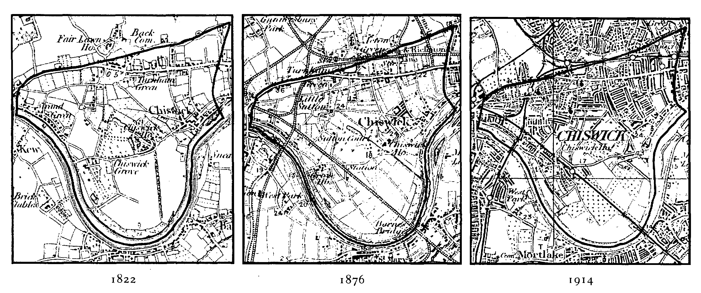
Chiswick: Evolution of settlement 1822-1914
(Scale 1 inch to 1 mile)
While housing thus stretched northward from Old Chiswick to the high road, and westward from Turnham Green along the high road through Gunnersbury towards Brentford, much of the centre of the parish remained open. (fn. 263) The attractions of Chiswick House as a retreat from London, however, dwindled as railways made the duke of Devonshire's provincial seats more accessible, while its estate increased in value as building land. The lull in building during the 1880s therefore did not prevent sales either of part of the gardens which the duke had leased to the Royal Horticultural Society or of 80 a. to the west, later known as Chiswick Park. Thomas Kemp Welch, the purchaser in 1884, intended to imitate Bedford Park, but restrictions on the type of housing delayed building on most of the land, bordering the new Sutton Court Road, (fn. 264) until the late 1890s.
By the early 1890s housing was almost continuous along the high road. The streets leading north to the Back common and the railway had been built up, including Belmont Road, Turnham Green Terrace, Thornton Avenue and, on the Hammersmith boundary, Goldhawk Road. (fn. 265) South of the high road there was still open land east of Devonshire Road, but housing was already advancing down Annandale Road and Chiswick Lane, towards what was soon to be an estate on some of the fields of the Prebend manor. (fn. 266) A compact area, it was known as the ABC estate, since its roads were named alphabetically from north to south, beginning with Ashbourne Grove and Balfern Grove. The plots, sold by the Ecclesiastical Commissioners in the 1870s, had been only partly built up when auctioned by the British Land Co. in 1896 (fn. 267) but contained 327 houses by 1901. The population density was high, with many houses divided among poor families. Immediately to the north the old Manor Farm House was replaced by Wilton Avenue in 1896, as part of a separate project. To the east some houses were built along the edge of Home field but were later demolished, the field itself being preserved for recreation while middle-class housing spread over the area to the north.
In the early 20th century building continued on land already intended for housing, as at Grove Park and Bedford Park or on the Homefield estate around Airedale Avenue, which had 256 houses and 40 flats, with room for more, in 1914. In the centre of the parish the remainder of the Royal Horticultural Society's gardens, with an exceptionally large house called Devonhurst, made way for 269 middle-class houses, and by 1911 Ellesmere Road had been built up, blocking the rural views from Barrowgate Road, as had part of Park Road. North of Grove Park plots were sold in 1904 for the Riverview estate, 110 terraced houses adjoining Strand-on-the-Green, and to the east the site of Little Sutton was offered in 1905. (fn. 268) Further building on the Chiswick Park estate had led to Staveley and Chesterfield roads and their neighbours being laid out, although not built up, by 1915. (fn. 269) Housing thus stretched from Old Chiswick north-westward to Turnham Green and thence south-eastward through Little Sutton to Grove Park and Strand-on-the-Green, curving around the much reduced grounds of Chiswick House, itself an asylum from 1896. Large blocks of private flats were built in many parts: they included Sutton Court on the site of the manor house, Prebend Mansions in Airedale Avenue and the high road, Dewsbury Crescent in Chiswick Road, and flats at the north end of Grove Park Terrace.
After the First World War there was little room for building in the northern half of the parish, where almost all the market gardens had vanished and the existing commons had been preserved for recreation. South of Burlington Lane, however, in addition to land which had been acquired by private sports clubs, (fn. 270) the duke of Devonshire still owned c. 200 a. of fields and gardens. Plans to sell them to the Brentford Gas Co. were frustrated by public protest and in 1923 they were bought for recreation by the U.D.C., (fn. 271) which retained some and leased or sold the rest. (fn. 272) Much of the peninsular part of the parish, long known as Duke's Meadows, therefore remained open.
Between 1911 and c. 1950 the building rate was about half that of the previous 40 years. (fn. 273) Chiswick Park and avenues such as Lawford and Staveley roads south-west of Chiswick House had finally been built up by 1935, while Chiswick House and its landscaped park were acquired for the public in 1929. Flat building continued, and some encroachment was made on the unbuilt land of the peninsula with new schools, sports pavilions near the river, and houses, as in Alexandra Avenue, along Great Chertsey Road. The most striking changes arose not from the spread of housing but from road widening and the cutting of Great Chertsey Road itself. (fn. 274)
The building of council houses, started in 1903 at Strand-on-the-Green, (fn. 275) continued in the period between the World Wars, (fn. 276) and increased after 1945. The sports grounds of St. Thomas's hospital, farther north than most playing fields, survived as an open space between Little Sutton and Grove Park (fn. 277) until their compulsory purchase in 1946. Brentford and Chiswick M.B. there carried out what was then its most ambitious housing scheme, for 220 flats, of which the first six, in Nightingale Close, were occupied from 1949 and a further 96 in 1952. (fn. 278) Other schemes included flats south-east of Burlington Lane in Edensor Road, where 138 were planned in 1948, (fn. 279) and tower blocks on the Hogarth estate, the first of which was named in 1953. (fn. 280) Private building in the whole borough in 1962 accounted for only one quarter of the c. 2,000 dwellings built since 1945. (fn. 281)
In keeping with a fall in the population from the peak recorded in 1931, (fn. 282) the period after the Second World War was remarkable less for the spread of housing than for the filling of small sites, for the conversion of large houses into flats, and for rebuilding. From the 1950s blocks rose along Chiswick High Road, industry tended to move away, (fn. 283) and the old parish became still more residential, with many suburbs, including those around the early villages, retaining a character of their own. Chiswick suffered more than most areas from the growth in traffic to London: the building of new roads had an even stronger impact than in the 1920s and 1930s, entailing much house demolition and helping to separate the northern and southern parts of the parish. In consequence local patriotism grew, early amenity societies were formed, (fn. 284) and the more select areas, where property values remained high, appeared still more strongly as oases of peace and some architectural distinction.
The population of the parish was 3,235 in 1801, 4,236 in 1821, and 6,303 in 1851. It rose very little in the 1850s and was only 8,508 in 1871, but had increased to 15,975 by 1881, 21,963 by 1891, 29,809 by 1901, and 38,697 by 1911. Thereafter it rose slowly to reach 40,938 by 1921 and a peak of 42,246, in the six Chiswick wards of Brentford and Chiswick, by 1931. Numbers fell to 42,207 in 1951 and 38,981 in 1961, after which date the wards were reorganized within Hounslow L.B. (fn. 285)