A History of the County of Shropshire: Volume 10, Munslow Hundred (Part), the Liberty and Borough of Wenlock. Originally published by Victoria County History, London, 1998.
This free content was digitised by double rekeying. All rights reserved.
'Ditton Priors', in A History of the County of Shropshire: Volume 10, Munslow Hundred (Part), the Liberty and Borough of Wenlock, (London, 1998) pp. 300-320. British History Online https://www.british-history.ac.uk/vch/salop/vol10/pp300-320 [accessed 19 April 2024]
In this section
DITTON PRIORS
Ditton Priors is a large remote upland parish equidistant (c. 15 km.) from Bridgnorth to the east and Much Wenlock to the north. (fn. 1) As communications improved in the early 20th century its isolation was reduced, and by the later 20th century a high proportion of the working population commuted to Bridgnorth, Ludlow, or Kidderminster (Worcs.). (fn. 2)
In the 19th century the parish contained 5,566 a. (2,253 ha.) (fn. 3) and comprised the three townships of Ditton Priors, Middleton Priors (including Derrington), and Ashfield and Ruthall. (fn. 4) About 0.1 ha. beside the Ditton–Abdon road was transferred from Ditton Priors civil parish to Abdon C.P. in 1967. (fn. 5)
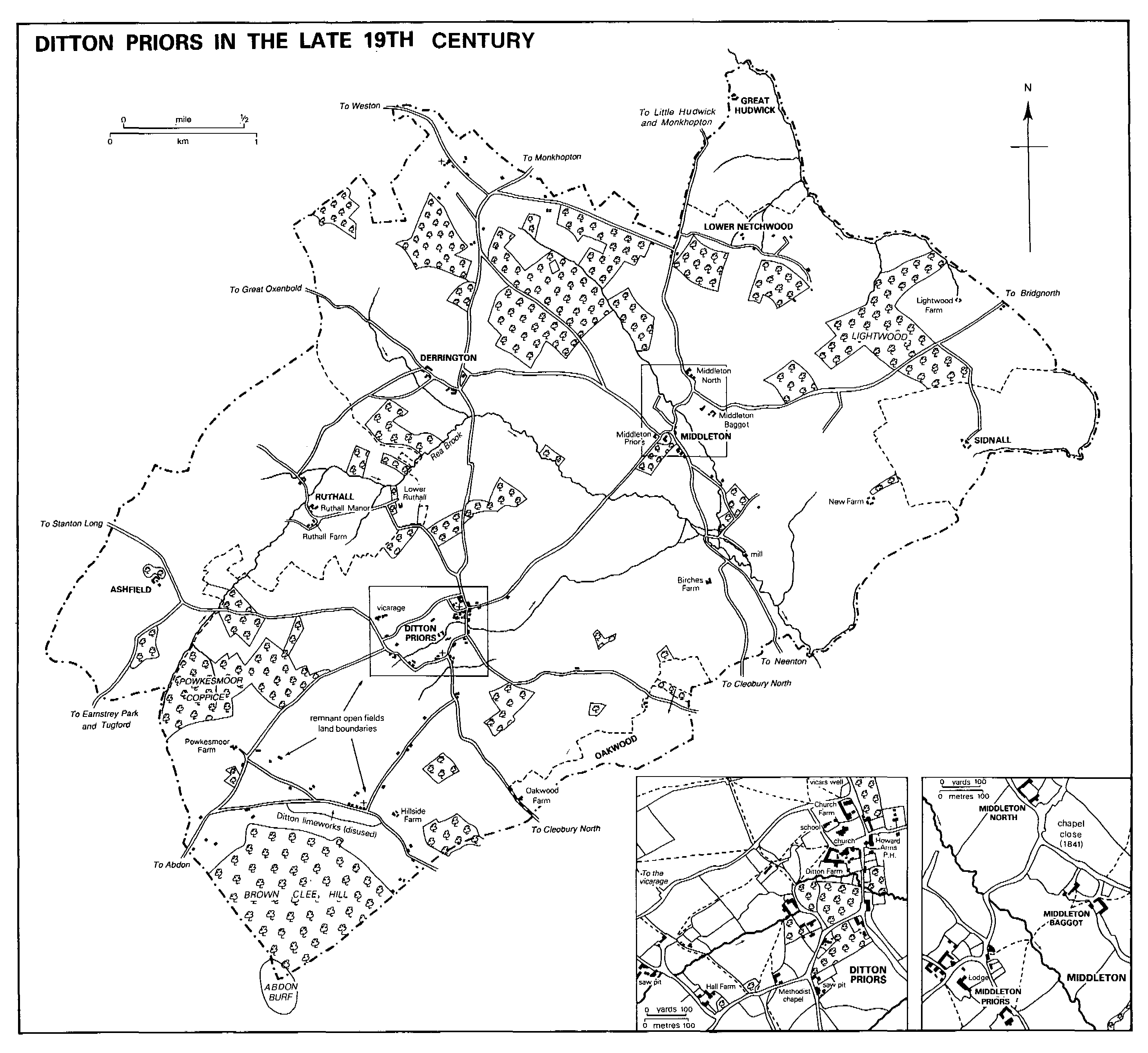
DITTON PRIORS IN THE LATE 19TH CENTURY
In places streams form the parish boundary, but only on the north-east side, where Beaconhill brook drains north down Park and Hudwick dingles, does that happen for any great distance. From the top of Park dingle the boundary runs south-east along the line of the former pale of Upton Cressett park, a manorial boundary in 1621. (fn. 6) The northern boundary, with Monkhopton, mostly follows the edge of the Clee Hills plateau but leaves the edge to exclude Little Hudwick and is in places defined by field boundaries. (fn. 7) The Brown Clee commons were divided probably in the earlier 17th century, and the boundary of Ditton's allotment later became that of the parish. (fn. 8) Elsewhere the boundary has a flowing line that suggests its definition by features such as the edges of woods.
Most of the parish lies at 200–250 m., falling below 140 m. only north of Great Hudwick where Beaconhill brook leaves the parish. (fn. 9) The parish includes the headwaters of the stream known, perhaps until the earlier 14th century, as the Neen (Nene) and thereafter as the Rea or South Rea; (fn. 10) anciently it probably divided Ditton from Middleton. Except for Ashfield the parish's settlements all stand on or near streams, principally the Rea and its tributaries. (fn. 11) Southwest of Ditton village the ground rises steeply to Abdon Burf, highest point (1,790 ft., 545 m.) in the midlands (fn. 12) and the northern of the two peaks on Brown Clee hill. The hill is composed largely of Breconian Beds folded in a syncline with thin sheets of Coal Measures, capped overall by hard olivine dolerite. It is thought that Clee hill gained the description Brown (from the local soil colour) in the 15th century to distinguish it from Titterstone Clee 10 km. south. Apart from Brown Clee the parish lies on Lower Old Red Sandstone (Ditton Series), in which some cornstone appears. (fn. 13) Tufa formations in Hudwick dingle secured the designation of a site of special scientific interest in 1963. (fn. 14)
A probable Ditton–Wenlock 'Portway' by Ruthall (1327), Oxenbold coppice, and Weston (1256) (fn. 15) was superseded; later roads from Ditton ran north (via Derrington and Weston) and west (via Ashfield and Stanton Long) into the principal Corve Dale route from Ludlow forking near Shipton to Bridgnorth and Much Wenlock; by c. 1350 another ran south to Cleobury North (fn. 16) where it joined a Ludlow–Bridgnorth road running east of the Brown Clee. The direct road from Ditton to Bridgnorth, via Middleton, recorded in the mid 13th century, (fn. 17) was turnpiked in 1762 but was 'very bad' in 1794. (fn. 18) In 1825 the turnpike was extended to the foot of Brown Clee hill and separate districts for Ditton Priors and Cleobury North were created. (fn. 19) There were turnpike gates in Ditton village (fn. 20) and at Lightwood. (fn. 21)
From Middleton a road (now only a footpath) south to Cleobury North crossed the Rea by a bridge that was probably called Broad bridge in the 13th and 14th centuries; (fn. 22) other ways by then ran south-south-east to Neenton (fn. 23) and northwest to Derrington, (fn. 24) and 'Dodeley way' and 'Othleye (Overleye) way' were names for some of the roads from Middleton. (fn. 25)
Two roads running south-west from Ditton village to the base of Brown Clee hill perhaps originated as 'strake' (drift) roads to the common. The eastern one, settled by squatters, was called Bent Lane. In the early 17th century there were also strake roads to the hill from Ashfield and from Ruthall, only the former outlasting straking. The inclosure of Brown Clee and Netchwood in 1841 wrought minor changes to roads in Ditton and Middleton villages and in the Lightwood area. (fn. 26)
Cleobury Mortimer and Ditton Priors Light Railway was built in 1907–8 to carry stone from Abdon Burf quarry. Worked by the G.W.R., it ran from Ditton Priors to Cleobury Mortimer where it joined the line from Bewdley to Tenbury Wells. There was a passenger service from Ditton 1908–38, and the line served the Royal Naval Armaments Depot (near Ditton village) 1939–65. (fn. 27)
Flints and perhaps a basalt axe hammer have been found at Lightwood and Oakwood, (fn. 28) while the parish's southern extremity lies within Abdon Burf hill fort. Until largely destroyed by mining and quarrying in the early 20th century, it was one of Shropshire's most impressive Iron Age forts. Oval and probably univallate, it enclosed c. 7 ha. Of particular note were its apparently stone faced ramparts. Within it 44 possible hut circles of stone were visible in the earlier 19th century, and at the junction of the divisions of the common (the later parish boundaries) was a big stone with 'a cross and letters' on it. (fn. 29)
Ditton and Middleton were clearly the two primary settlements. A possible interpretation of Ditton's name is 'place near a hill'. (fn. 30) Middleton's name seems to indicate its mid-way location between the townships of Ditton and Upton (Cressett) (fn. 31) but may possibly refer to its position between Rea brook and its tributary to the east. (fn. 32) By 1066 Middleton was probably one of Ditton's four berewicks (unnamed in 1086), (fn. 33) the others perhaps being the settlements to the north unnamed in 1086 but probably then in existence, Derrington and possibly Weston and Hopton. (fn. 34) Ruthall had probably once been a member of Ditton (fn. 35) but was manorially distinct by 1066. (fn. 36) Ditton, Middleton, and Ruthall (and perhaps Derrington) had open fields in the early 14th century. (fn. 37)
In Ditton Priors there were 12 tenements in 1510–11, fewer than in Middleton. (fn. 38) The only medieval timbers known in the parish are those re-used in the eastern half of Ditton Farm, which has a later 17th-century stair turret. (fn. 39) There is substantial 17th-century work in Church Farm, (fn. 40) which has traces of 17th-century wall painting on the gable of an upper chamber, and in Hall Farm (1693). (fn. 41) By the 1720s the manorial estate had some cottages and a dozen farmhouses in Ditton township, (fn. 42) probably most of them in or near the village. Also in the village, near the church, stood the vicarage and a public house, now the Howard Arms, one of the larger 18th-century buildings in the parish. (fn. 43) Alone among settlements in the parish Ditton grew in the 20th century. Between the 1920s and the 1940s more than 20 houses were built in and around the village: 16 in two rows near Hall Farm were for quarrymen, and there were 5 houses for county council smallholdings, built to accord to the national 'Type 2' but on a system using locally cast concrete panels and posts. (fn. 44) In 1955 an incongruous yellowish brick was used for 20 council houses in Brown Clee Road, off Station Road on the east side of the village. (fn. 45) The village was made a conservation area in 1982, (fn. 46) and in the mid 1980s houses there were increasing through refurbishments and barn conversions: Ditton Farm and its buildings, for instance, were made into 14 small dwellings.
In 1939 a Royal Naval Armaments Depot was established south-east of Ditton village and extending into Cleobury North and Neenton parishes on land made available by Lord Boyne. (fn. 47) After the Second World War the land was densely planted with Japanese larch. (fn. 48) The U.S. army used the depot as a temporary ammunition dump 1967–8, but by 1971 the adjoining land was available for agriculture again and some depot buildings had been sold for industrial use.
In the 1840s the lord of the manor piped water to Ditton village from a spring on Brown Clee hill and set up three or four public taps; one (1845) has an ornate arched stone surround. (fn. 49) In the 19th century 'parson's' or 'vicar's' well lay in Well meadow just north of Ditton; (fn. 50) it was perhaps a public well. In the 1940s the armaments depot and New Hall Farm were supplied by boreholes. (fn. 51) Ditton village received mains water in 1968, (fn. 52) electricity by 1979, (fn. 53) and a main sewer in 1985. (fn. 54)
Extensive earthworks in fields around Hyde Farm show that the nucleus of settlement at Middleton Priors was once considerably larger. In 1510–11 there were c. 15 tenements in Middleton and a church, (fn. 55) but in 1625 mention of Hither and Further Middleton (fn. 56) suggests that the settlement had already shrunk and lay dispersed, as in the 18th century. Hyde Farm is a stone and timber framed building of the 16th century and later (fn. 57) while Middleton Baggot, Middleton North, and the north range of Middleton Lodge are substantially 17th-century. In the Middleton half of the parish 20 of the houses that paid hearth tax in 1672 had one hearth, 7 had two, 2 had three, and the other 4 had four, five, six, and seven. (fn. 58) Middleton Lodge (fn. 59) is among the larger 18th-century buildings in the parish. By the 1720s the manorial estate included 10 farmhouses, some cottages, and a mill in Middleton Priors township. (fn. 60) Settlement continued to shrink in the 18th century. The chapel of ease closed c. 1780, and by the early 19th century the hamlet consisted of little more than the scattered Middleton Lodge, Hyde Farm, Middleton Baggot, and Middleton North. (fn. 61) Later in the century a school (fn. 62) and two or three cottages were built.
Derrington and Ruthall, north of Ditton, were minor settlements. Five men were described as 'of Ruthall' in 1312. (fn. 63) There were three tenements at Derrington in 1510–11 (fn. 64) and three substantial farmhouses there in the 1720s, Ruthall being about the same size. (fn. 65) By the end of the 19th century Derrington had shrunk to two farms, (fn. 66) but there were four at Ruthall in the 1980s, including Lower Ruthall 0.5 km. east of the others. The northern end of Derrington Manor Farm is 16th-century and it has a later 17th-century stair turret with the original staircase in situ. (fn. 67) Derrington Farm (formerly Derrington East) contains substantial 17th-century work (fn. 68) as do Ruthall Manor (fn. 69) and Upper Ruthall, a stone building mainly of c. 1800. Ruthall Farm was refronted and enlarged in the late 18th or early 19th century.
Ashfield, Great Hudwick, and Sidnall, respectively at the western, northern, and eastern extremities of the parish, were small in post-medieval times. At Ashfield and Sidnall, however, earthworks indicate bigger medieval settlements. In 1401 there were perhaps five farms at Ashfield, (fn. 70) and Sidnall's former earthworks (fn. 71) suggest that it may once have been of comparable size. (fn. 72) By 1510–11 the manorial estate included a single tenement in Hudwick and one in Sidnall, (fn. 73) and by the mid 18th century Ashfield also seems to have consisted of only one farm. (fn. 74) Great Hudwick was long uninhabited before 1986 when the remaining building, a barn, became a house. (fn. 75)
By the 1720s squatters had settled in the north at Netchwood and in the south around the bottom of Brown Clee; each area had c. 23 cottages. (fn. 76) At Netchwood in 1841 there were c. 28 cottages in two main concentrations, one at each end of the common, and by 1847 each had a Methodist chapel. (fn. 77) In the 20th century the western cluster was known as Upper Netchwood, the eastern as Lower Netchwood. In the later 19th (fn. 78) and the 20th century the number of cottages at Netchwood declined by about half. In the south the pattern was similar: in 1841 there were c. 18 cottages around the bottom of Brown Clee hill and c. 10 more along Bent Lane. (fn. 79) In the later 19th and early 20th century many were quarrymen's homes and some no more than wooden shacks with iron roofs. (fn. 80) Again the number has declined. (fn. 81)
Invariably the external walls of ancient farms in the parish (many containing substantial 17thcentury work) are of the local dhu stone (dolerite) or sandstone, although internal walls are sometimes timber framed. Powkesmore brickyard was open by the early 19th century, but the ready availability of stone confined brick's use in the parish to the larger buildings (and often to their façades) like Ruthall Manor (c. 1820), the Vicarage (1828), Lower Ruthall, Sidnall, and Ashfield Farm (1878). (fn. 82) Clay roof tiles began to be commonly used in preference to stone slates in the late 19th century, (fn. 83) and brick and concrete were used in and around Ditton village in the 20th century. (fn. 84)
In 1086 Ditton's recorded population was 38, Ruthall's 5. (fn. 85) In Ditton 18 paid to the subsidy in 1327 and in Ashfield 4; Ruthall was then taxed with Easthope 5 km. to the north-west, the two places having a combined total of 10 taxpayers. (fn. 86) In 1542 ten men from Middleton were mustered, 9 from Ditton, and 3 each from Derrington and Ruthall. (fn. 87) The 1642 Protestation was taken by 118 men, with one refusal, (fn. 88) while in 1676 there were 424 parishioners, perhaps including children. (fn. 89) In 1672 hearth tax was paid by 29 householders in the Ditton half of the parish, 33 in the Middleton half. (fn. 90) The parish's population continued to grow, mostly, if not solely, in the squatter settlements. There were 608 inhabitants and 132 houses in 1794. For most of the 19th century the population fluctuated around 600– 650, but, for reasons that are obscure but may have included the closure of the limeworks, (fn. 91) it fell sharply in the 1880s and 1890s, to 505 by 1901. In the 20th century it was usually just over 600, though the armaments depot was presumably responsible for increasing the population to a record 701 in 1951. In 1981 it was 547. (fn. 92)
After 1176 (and possibly before) the lord of Ditton did not reside, and in 1794 only two of the eleven landowners did—Elizabeth Onslow, owner of a small property at Ruthall, (fn. 93) and the vicar. In the 1790s there was often no borough magistrate nearer than Wenlock and even Ashfield and Ruthall (outside the borough) were far from a resident justice. (fn. 94) There was nevertheless some social life in the 18th century. Midsummer day wakes were held in 1733, (fn. 95) and in the 1780s an annual hunt was attended by local gentry and the more prosperous tenant farmers. (fn. 96) In the late 18th and early 19th century there were two alehouses in the parish. (fn. 97) In Ditton the Plough and the Canning Arms were open in 1851. (fn. 98) The Plough had closed by 1871, but there were two ale sellers at Netchwood in the 1870s. (fn. 99) The Canning (from c. 1860 Howard) (fn. 100) Arms remained open. In the 19th century and until the First World War the high sports of the annual round of fêtes, sports, and 'club' events were perhaps Ditton's spring and autumn fairs, though Bridgnorth fair and regatta were outside attractions. (fn. 101) A cricket club formed in 1868 by the energetic vicar J. B. Wilkinson had 29 members in its first season and perhaps lasted into the early 20th century. (fn. 102)
The parish had a friendly society in the late 18th and early 19th century (fn. 103) and two a hundred years later; there was a mutual improvement society c. 1880–1920 and a lodge of the National United Order of Free Gardeners which paraded in 1894. A parish library was associated with the mutual improvement society, and in 1926 a county library book centre opened. (fn. 104) Other parish clubs and societies included a band (mentioned 1923) (fn. 105) and a Women's Institute (1924). (fn. 106) In 1967 the former armaments depot canteen was bought for a village hall. About 1980 land north of the church was bought as a recreation field for the village clubs and school; a pavilion was built there in 1983. Brown Clee was then increasingly used for recreation: a nature trail had opened c. 1970, at which time there was an annual sponsored race up the hill. (fn. 107)
MANORS AND OTHER ESTATES.
In 1066 DITTON was held by Edwin, earl of Mercia (d. 1071), and in 1086 by Roger of Montgomery, cr. earl of Shrewsbury 1068. (fn. 108) Earl Roger's son Earl Robert forfeited his English estates in 1102, (fn. 109) and Ditton remained in the Crown's hands until granted to Hugh of Periers in 1154–5. Periers entered Wenlock priory and gave it the reversion of the manor after the death of his wife Alice de Cheney. When Periers died (1175 or early 1176) the king assigned the manor to the priory which, however, recognized Alice's interest and presumably compensated her. Alice remarried, and in 1180 her husband Geoffrey de Say obtained new terms from the priory: it was to pay 160 marks down to cover all Say's claim to the manor for eight years and after that an annuity to his wife. Wenlock retained the manor until its surrender in 1540. (fn. 110)
In 1544 the Crown sold the manor to Humphrey Pakington, a London mercer, to be held in chief as ¼ knight's fee for a reserved rent, sold by the Crown in 1550. (fn. 111) Humphrey was succeeded by his son John (d. 1578), of Chaddesley Corbett (Worcs.), and John by his son Humphrey, of Harvington Hall. Humphrey's recusancy led to the Crown's seizure of the manor and rectory in 1591, and the Crown then farmed it out. (fn. 112) Nevertheless Humphrey (d. 1631) settled the manor on his daughter Anne (d. 1642) and Sir Henry Audley (d. c. 1672) of Berechurch (Essex) when they married in 1628.
The Audleys' eldest surviving daughter Catherine married Robert Barker of Monkwick (Essex), who predeceased her. They left two sons Thomas (d. 1704) and Bestune (d. 1705) and the manor was later divided between their sister Apollonia (d. 1713), who married Francis Canning (d. 1734) of Foxcote (Warws.), (fn. 113) and their spinster aunt Mary Audley of Ramsden Heath (Essex). Mary's moiety was reunited with the Cannings' on her death in 1722, (fn. 114) and the manor descended from father to son until 1831: to Francis (d. 1766), Francis (d. 1806), and Francis (d. 1831). The last left no issue, and the manor passed first to his brother Robert (d. 1843) and then to their niece Eliza Minto Canning (d. 1865), who married P. H. Howard of Corby Castle (Cumb.). (fn. 115) Between 1874 and 1878 the estate passed to the Howards' son P. J. C. Howard, who in the 1880s sold c. 1,800 a. of it to G. R. Hamilton-Russell, Viscount Boyne, and died in 1934. His widow Mrs. A. C. Howard (d. 1941) was afterwards lady of the manor. (fn. 116)
Hall Farm, a T shaped stone building of two storeys and an attic, was built by Catherine Barker in 1693. Some windows have moulded labels, an unusual elaboration for the locality. (fn. 117)
When Hugh of Periers granted Ditton to Wenlock priory parts at least of MIDDLETON had been subinfeudated, and Periers safeguarded the rights of his tenants in fee there: Achilles, Walinger of Sidnall and his brother Aubrey, and Adam the butler (pincerna). (fn. 118) Adam was presumably Periers' butler, (fn. 119) and later landowners in Middleton, to judge from their surname Chamberlain, may have derived their estate from predecessors who served the lord of Ditton in a personal capacity. Stephen Chamberlain held an estate in Middleton of Wenlock priory and by 1256 had fallen behind with his rent of ½ mark; (fn. 120) he gave land to his daughter Agnes (fn. 121) and passed on the estate to his son William. William alienated many properties in Middleton, (fn. 122) thus perhaps breaking up his estate.
A sequence of personal names suggests a line of Middleton landowners descending from Adam the butler. William (fl. 1180) son of Adam (fn. 123) was probably the William Clerk of Middleton who, in the earlier 13th century, held 1 virgate in Middleton of Engelard of Acton for 5s. a year. (fn. 124) In the mid or later 13th century William Clerk's son Adam sold the virgate to Richard Clerk, son of the rector of Burwarton. Engelard of Acton's interest later seems to have passed to Wenlock priory. (fn. 125) There may have been a dynasty of clerks (later the Clerk family) serving the priory in various ways. Richard of Middleton (d. 1323 × 1329), clerk, perhaps the same as Richard Clerk, purchaser of the virgate, was also known as Richard of the farmery (i.e. infirmary). He left a widow and sons Richard and Roger le Clerk, (fn. 126) of Middleton. Roger may have been the Roger le Clerk who left a son John (fl. 1349), (fn. 127) possibly the John Clerk who was father of Gillian Low or Leye (fl. 1401–28). (fn. 128) The 1-virgate farm was known by 1510–11 as HYGGS (fn. 129) or HYGGS YARD. (fn. 130) Gillian Leye and her husband apparently sold it to John Page of Oxenbold in 1401 and later that year Page sold it to Richard de Arderne, the vicar. In 1418 Walter Arderne conveyed the farm to Thomas Hochekyns, but by 1428 it seems to have belonged to Richard de Arderne's nephew Richard Kynston of Ludlow. In 1443 Kynston sold it to Thomas Downe. William Clerk, esquire, bought the property from Downe's mortgagee in 1477, (fn. 131) and Thomas Clerk probably had it by 1510–11; he sold it in 1543 to John Taylor, who sold it to Richard Fewtrell in 1545. (fn. 132)
Wenlock priory had probably acquired most of the land in Middleton by the early 16th century, (fn. 133) leaving Hyggs Yard and Sidnall (fn. 134) as the only known lay estates. By 1230 it had bought 8½ virgates once Richard of Ruthall's and 1 virgate once William of Middleton's. (fn. 135) In the earlier 14th century much land in Middleton was sold (fn. 136) and it apparently passed ultimately to the priory.
The priory's land in Middleton evidently passed with Ditton manor to the Howards. In 1949 Mrs. A. C. Howard's only child Ursula, Lady Lawson (who became Mrs. Levin that year), sold Home farm, Middleton, the remnant of the Howard estate, to Joseph Bell, whose father had long been the family's agent. In 1950 Bell sold it to Mr. and Mrs. Albert Corfield, who had bought Middleton North in 1926 and Middleton Baggot in 1948. (fn. 137)
About 1945 the Howards' seat, Middleton Lodge, was bought from their estate by E. T. Rowlands. (fn. 138) Known in the 19th century as Middleton Hall, it is a large L shaped stone building of two and three storeys. Its core is perhaps 17th-century, but the building was greatly enlarged and refronted in the 18th century. There were also alterations in 1845, and then or later the house was divided into three dwellings. (fn. 139)
Hudwick was probably in Ditton manor in the Middle Ages. In 1510–11 John Marcus paid Wenlock priory £1 6s. 8d. a year for his tenement there. (fn. 140) The Crown separated what was evidently GREAT HUDWICK from Ditton manor, selling it in or before 1543, when Robert Burgoyne of London sold the farm there, occupied by Joan Markys, widow, to Matthew White of London. (fn. 141) In 1544 White sold it to Thomas Cressett (d. 1566), (fn. 142) who was succeeded by his son Francis. (fn. 143) Francis sold it in 1589 to Sir Rowland Hayward (fn. 144) (d. 1593) who in 1592 settled Hudwick manor or farm on his wife Catherine and their son George (kt. 1604, d. 1615), whose heir was his brother John (kt. 1619). Catherine survived in 1617, (fn. 145) but Sir George was lessor of the estate in 1612. (fn. 146)
Great Hudwick had passed to the Actons of Aldenham by 1662, when Sir Walter conveyed it to his brother Thomas (d. 1678). Thomas Acton's daughter Sarah owned it in 1682. (fn. 147) She afterwards married John Whitmore (d. 1715), of Ludstone (in Claverley), and in 1726 conveyed the manor to her son George (fl. 1737). In 1752 George Whitmore's sister Mary Osborne released her interest in Great Hudwick to her son Charles Osborne, who sold it that year to Edward Minton of Westminster. (fn. 148) It probably descended thereafter with the Coates (in Holdgate) (fn. 149) to Edward Howells (d. c. 1830); his nephew Thomas (fn. 150) was in possession in the 1870s. George Howells was recorded as owner between 1881 and 1900, and in 1910 Elizabeth Howells owned the 125-a. property. (fn. 151) It later became part of the Burwarton estate. (fn. 152)
Hudwick House or Farm, long uninhabited, was demolished in the 1950s. In 1985–6 its barn was converted into a large new house. (fn. 153)
William Hide (d. 1792) left OAKWOOD, a 56-a. farm in 1799, to his son Thomas, on whose death (1805) (fn. 154) Oakwood, like Ruthall, passed to his brother William (d. 1807). William's son Thomas sold Oakwood in 1821 to his cousin's husband William Millward. (fn. 155) The property then comprised the house and 65 a. (fn. 156) Millward sold it to G. F. Hamilton-Russell, Viscount Boyne, in 1858, (fn. 157) and it remained part of the Burwarton estate. (fn. 158) Oakwood, a stone farmhouse, was probably built in the later 18th century. (fn. 159)
LITTLE HUDWICK remained in the Ditton Priors manorial estate until 1730. (fn. 160)
Hugh of Periers subinfeudated SIDNALL, and when he gave Ditton to Wenlock priory the tenant was Walinger of Sidnall (or of the Dykes, des Diches). Walinger and perhaps a namesake flourished 1176–1226. (fn. 161) Thomas of Sidnall was lord by 1301 and in 1323. William, perhaps Thomas's nephew, was lord in 1345–6. (fn. 162) In 1510 a chief rent was due from Sidnall to Wenlock priory. (fn. 163)
From 1519 or earlier Sidnall descended with Ashfield (fn. 164) until Thomas and Mary Smith sold the manor in 1561 to John Bullock (d. 1574), presumably a kinsman of Richard Bullock, Sidnall's lessee in 1510–11. John Bullock's son Nicholas (d. 1591) was next lord and was succeeded by his son John, (fn. 165) who was presumably dead by 1641 when his brother or nephew Edmund Bullock owned the manor. (fn. 166) By 1652 Sidnall had passed to John Careswell of Shifnal. His son Edward Careswell (d. 1689) included Sidnall in his 1,000-a. endowment of 18 exhibitions at Christ Church, Oxford. (fn. 167) Careswell's trustees sold Sidnall farm (c. 218 a.) in 1920 to Francis Myatt, a Wolverhampton brewer. (fn. 168) Sidnall Farm is an early 19th-century brick building.
There were other freehold estates in Sidnall in the late 16th (fn. 169) and early 17th century. (fn. 170)
ASHFIELD, presumably part of Ditton manor in 1086, was probably granted before 1155 to an ancestor of the Beysins. It was part of their serjeanty of keeping the king's hawks. (fn. 171) In 1198 Adam de Beysin was said to hold ¼ carucate in Ashfield. (fn. 172) About 1225 he gave his lands at Ashfield, then said to be 2 virgates, in marriage to his daughter Margery and Thomas of Badger (d. by 1246). Margery later apportioned Ashfield among her younger children: Henry Mauveysin received 1½ virgate c. 1252, Richard of Badger 1 virgate c. 1254, and Avice of Badger ½ virgate c. 1255. (fn. 173)
Henry Mauveysin (fl. 1255) was perhaps Margery's son-in-law. By 1292 his second son Thomas Mauveysin (or of Berwick, fl. c. 1285), to whom Ashfield had apparently passed, had died leaving a son and heir John of Berwick, a minor; Ashfield was held of John for life by his uncle Philip Mauveysin (or of Berwick). (fn. 174) Philip outlived John and acquired the fee. He died c. 1334 seised of a messuage and virgate in Ashfield held in chief by service of 4s. a year. Philip's heir was John's son John of Berwick, (fn. 175) who died in 1349 seised of ½ virgate in Ashfield held by knight service. John of Berwick's heir was his son Thomas aged 18. (fn. 176) Ashfield later passed to Philip of Berwick's kinsman and heir Richard Berwick of Berwick Maviston. By 1401 Richard had sold the estate, perhaps then 3 messuages, 4 virgates, and 10 a. of meadow, to John and Gillian Burley. (fn. 177)
Richard of Badger, who had received 1 virgate c. 1254, was said c. 1284 to hold Ashfield as 1/6 knight's fee of Walter de Beysin, the tenant in chief. (fn. 178) Richard died before 1292 and his heir was his son Roger (fl. 1320), but in 1292 the virgate was held by Richard's widow Margery. It was forfeited to the Crown as an unlicensed alienation from the Beysin serjeanty by 1304 when 1½ virgate and 3 a. in Ashfield, once Margery's, were in the king's hand. They remained so in 1345 but seem to have been restored to the Badgers by 1346, when Roger of Badger (fl. 1349), perhaps Margery's son of that name, granted a lease in Ashfield. (fn. 179) The later descent of Roger's estate has not been traced.
Richard of Badger enfeoffed Adam le King in a messuage and ½ virgate in Ashfield, said to be held in chief for 2s. 10d., which Adam was to pay to Richard. Adam le King was succeeded by William le King (d. by 1319), whose heir was his son Nicholas (fl. 1320). (fn. 180) By 1346 the estate was probably that held by John King (or Carles) (d. by 1377), which was said to comprise 2 mes suages, 1 virgate, and 6 a. of meadow in Ashfield. On John's death the estate passed to his kinsman and heir William son of Richard Herdewyk, who by 1401 had sold it to John Burley. (fn. 181) Burley thus held at least two of the three portions into which Ashfield had been divided c. 1255. (fn. 182)
The ½ virgate granted to Avice of Badger c. 1255 was held in 1292 by Thomas de la Cole. (fn. 183) It was perhaps later absorbed into the Kings' estate which was enlarged from ½ to 1 virgate between the later 13th century and 1377. (fn. 184)
By 1452 the estate, then reputed a manor, was apparently reunited under John Talbot, earl of Shrewsbury, and then descended with Aston (in Munslow) until 1542. (fn. 185) In 1559 Sir John Smith's son William conveyed Ashfield to his brother Thomas in return for a life annuity and discharge of his debts. (fn. 186) In 1561 Thomas Smith sold part of the estate, probably a moiety, to William Holland of Burwarton (d. 1590). (fn. 187) Another moiety of Ashfield manor belonged to Richard Hopton of Over Bitterley. In 1589 Hopton's son Thomas sold it to Jasper More of Larden. (fn. 188) Thomas Hopton's widow, with Thomas Hopton of Nether Bitterley, bought it back from More in 1599, and Hopton sold it in 1602 to Thomas Langley of the Amies (in Broseley). (fn. 189) In 1613 Langley sold the moiety to William Holland (d. 1642), who thus seems to have reunited the manor, a share of which his grandfather had bought in 1561. (fn. 190)
The manor then descended from father to son in the Holland family, the following being lords: (fn. 191) Thomas, William (d. 1699), Thomas (d. 1722), and William (d. 1736). William Holland's relict Anne Crump was in possession in 1748, and his son Bernard (d. 1803) had 220 a. there in 1799. (fn. 192) Bernard Holland was succeeded jointly by his sisters Elizabeth (d. 1822), wife of Benjamin Baugh (d. 1809) of Ludlow, and Margaret (d. unm. 1808). (fn. 193) The Baughs' daughter Harriet (d. 1854), wife of Gustavus Hamilton, Viscount Boyne (d. 1855), owned Ashfield in 1851. (fn. 194) In 1910 it belonged to the Boynes' great-grandson F. G. Hamilton-Russell. (fn. 195) Ashfield Farm was rebuilt in brick in 1878 after a fire. (fn. 196)
In 1066 Eskil (Oschil) held RUTHALL, and in 1086 Gerelm held it of Gerard of Tournai who held it of Earl Roger, the tenant in chief. Gerard probably forfeited his mesne lordship, and in 1102 Earl Robert forfeited the overlordship. By 1203 Ruthall was held in chief by Ralph Sandford of Sandford (in Prees), which had also been held of Gerard in 1086. (fn. 197) The Sandfords retained the overlordship until 1552 when George Sandford exchanged it with Richard Moreton of Haughton. (fn. 198) Moreton's granddaughter Anne married Humphrey Briggs (d. 1626), and the overlordship of Ruthall descended thereafter with Abdon. (fn. 199) In 1872 chief and fee-farm rents from Ruthall and Ditton were part of the Abdon estate of G. R. C. Herbert, earl of Pembroke and Montgomery. (fn. 200)
Philip of Ruthall, apparently as heir of his brother John of Ruthall (d. by 1203), was Ralph of Sandford's tenant in Ruthall by 1221. (fn. 201) John of Ruthall (fl. 1227) or others of that name were lords of Ruthall in 1255 and 1284. (fn. 202) William Bastard was lord in 1292 and 1316. (fn. 203) William's brother Edmund Bastard (d. 1332) had an estate in Ruthall, jointly with his wife Agnes and allegedly by grant from John Lengleys, perhaps a feoffee. Shortly before his death Edmund was outlawed and his land seized. (fn. 204)
Sir William Yonge (d. by 1505) had an estate in Ruthall. (fn. 205) His son Francis (d. 1533) was lord and was succeeded by his son William (d. 1565). William's heir was his brother Thomas (d. 1569), vicar of Bampton (Oxon.). (fn. 206)
In 1599 Edward Lacon and his wife conveyed Ruthall manor to Richard and Joan Churchman, (fn. 207) who in the same year conveyed half of it to Nicholas Hints (d. 1600). Hints settled the moiety on his second wife Alice who, after Nicholas's death, married John Smallman. In 1612 the Smallmans reunited the manor by buying the Churchmans' moiety. (fn. 208)
The manor may have passed, like John Smallman's estate at Norncott (in Stoke St. Milborough), to Nicholas Page (d. 1684). (fn. 209) In 1690 Alice Page, widow, with Ada and Elizabeth Page, had Ruthall manor. (fn. 210) By 1706 moieties belonged to Ada (d. 1716) and Elizabeth (d. 1734) and their respective husbands Richard Langford (d. 1709) and Francis Milner (d. 1710). (fn. 211) Francis Milner, probably the son of Elizabeth and Francis, (fn. 212) seems to have been in sole possession by 1768 (fn. 213) and probably sold it c. 1769. (fn. 214) Joseph Sparkes of Bridgnorth, lord by 1779, (fn. 215) sold it in 1784 to William Hide (d. 1792), of Oakwood, (fn. 216) who left Ruthall to his son Thomas. (fn. 217) Thomas, who had 150 a. there in 1799, (fn. 218) died in 1805, leaving the manor to his brother William (d. 1807), who left it to his son William until his other son Thomas (d. 1825) came of age and would succeed. (fn. 219) In 1826 or 1827 Thomas Hide's widow Sarah married William Gough of Bridgwalton (in Morville). (fn. 220) In 1835 trustees sold the manor with the manor house and 172 a. to Thomas Roberts of Broseley, lord in 1851. (fn. 221) In 1869 and 1881 Edward Rainforth owned the estate, then 172 a. (fn. 222) In 1909, when the estate was only 76 a., it was sold by George Robinson's trustees, (fn. 223) probably to Joseph Poole of Dawley, who owned 220 a. in Ruthall in 1910. (fn. 224)
Ruthall Manor is a stone building, probably 17th-century. It was refronted in brick and modernized c. 1820. Earthworks suggest that the medieval manorial buildings, which included the chief house and a dovecote c. 1330, stood east and north of it. (fn. 225)
By the 14th century there were several freeholds in Ruthall. (fn. 226) In 1334 Hugh Tyrel had freehold lands there. (fn. 227) They may have passed, with his Norncott lands, to William Burley (d. 1458), of Broncroft, for by 1499 they were descending with Burley's manor of Brockton. (fn. 228) In 1552 John de Vere, earl of Oxford, sold his moiety to John Stringfellow, whose son Richard had it c. 1560, (fn. 229) but the later descent of the Ruthall lands has not been traced.
Ankaret, Baroness Talbot (d. 1413), wife of Sir Richard Talbot, held lands in Ruthall of Nicholas Sandford. (fn. 230) They descended to her grandson John Talbot, earl of Shrewsbury (d. 1460); in 1468 his son John, 3rd earl (d. 1473), entered on the estate comprising 2½ messuages, 24 a., and 10s. of assize rent. (fn. 231) His uncle Sir Humphrey (d. 1493) had an estate in Ruthall, (fn. 232) which may thereafter have descended with Aston (in Munslow), for Sir John Smith owed a chief rent to the lord of Ruthall in 1544. (fn. 233)
William Benyon (d. 1610) held a house and 100 a. in Ruthall in chief by knight service. (fn. 234) Thomas Benyon sold it to William Cotton and his son William in 1637. In 1640 the younger William, with others interested in the estate, conveyed it to Edward and Anne Hassold (or Hassall) of Deuxhill. John Collins bought it from the Hassolds in 1649 to settle on his son William's marriage with Ann Corfield. In 1682 the Collinses' estate was bought by William Pinches (d. 1712), glover, of Longville. His nephew and namesake sold it, heavily mortgaged, to Josiah Miles in 1727, when Miles also bought two messuages in Ruthall from Sir John and Lady Astley. The Astleys', later Tankervilles', estate retained some interest in the parish in 1834. (fn. 235)
The RECTORY appropriated to Wenlock priory was worth £12 a year in 1291, (fn. 236) and £8 3s. 4d. in 1379. (fn. 237) The monks of Wenlock let some of their appropriated Ditton tithes to vicars before the Dissolution, and the great tithes of Middleton Priors evidently belonged to the vicar after Middleton was reunited to Ditton in the earlier 16th century. (fn. 238) The priory's appropriated tithes passed to the Crown in 1540 and in 1544 were bought by Humphrey Pakington with the manor, (fn. 239) thereafter descending with it. (fn. 240) In 1728 it was said that the lord of the manor's great tithes would be worth c. £80 a year when the fields were inclosed, (fn. 241) but he sold Ruthall and Oakwood tithes in 1803 (fn. 242) and Ashfield's in 1807; (fn. 243) Sidnall's were sold about the same time to John Maddox, the occupier. The impropriate tithes were extinguished at inclosure in 1841 when lands were allotted in their stead to Robert Canning and the smaller impropriators, the more substantial of whom had property in Ashfield and Ruthall. (fn. 244)
ECONOMIC HISTORY.
Agriculture.
Ditton was held with four berewicks in 1066. In 1086 there were 5 ploughteams and 10 servi on the demesne, and 20 villani and 8 bordars had 6 teams; 13 more teams could have been employed. (fn. 245) The vill had a salt pan that rendered 2s. a year; it was at 'Wich', presumably Droitwich (Worcs.). (fn. 246) Ditton was worth £10 in 1066 and £11 in 1086; 12 hides there paid geld. At Ruthall, where ½ hide paid geld, there was enough land for 2 ploughteams, but only 2 half-teams were employed, one by 2 oxmen on the demesne, the other by 3 bordars; Ruthall was worth 6s. in 1066, 8s. in 1086.
Ditton, Middleton, and Ruthall were surrounded by open field land that was perhaps divided and regulated less formally, at least in the relatively well documented 13th and 14th centuries, than was usual in typical champaign English regions. Meadow, some of it common, flanked the Rea and its tributaries. (fn. 247) Around much of the edge of Ditton were woods and extensive tracts of common waste, their exploitation complicated by Ditton's inclusion in Clee forest. (fn. 248)
In the earlier 14th century most or all of Ditton's open field land lay in an arc west and south of the village, bounded in part by Powkesmore and Brown Clee hill. The land, whether or not divided formally into two or three fields, was in discrete culturae or divisions called 'Ardesley', near the road to Cleobury North, and 'Dykes', near the Cleobury North parish boundary. (fn. 249) Some or all of the demesne lay in a compact block in or near 'Ardesley'. (fn. 250) Middleton's open arable lay east, west, and south of the village, noted in the 13th century as in the fields towards Derrington and Neenton and in 'Cruftinge', 'Colverdale', 'Eddesley', and Bent fields, and in the 14th century as in the field or fields towards Ditton and 'Eddesley' and in Broadbridge field. (fn. 251) Other, apparently smaller, divisions of 'the field of Middleton' included furlongs, crofts, and 'Sevenacre'. (fn. 252) There was apparently an extensive area of strip cultivation divided by hedges, ditches, and roads into numerous enclosures, most in a nominal field. Selions were usually reckoned at ¼ a., but some as little as 1/8 a. (fn. 253) About 1300 Ruthall had open fields towards Ashfield, Ditton, and Weston; (fn. 254) the two last may be the fields towards the Clee and the park mentioned slightly later, (fn. 255) and there was an area that was a main field division or else a separate close in strips. (fn. 256)
The smaller enclosures that seem, along with large open fields, to have been components of the parish's field systems (fn. 257) probably often resulted from assarting, (fn. 258) encouraged by Wenlock priory in the 13th century. In 1232 the forester of Clee recognized the assarts made by Wenlock priory since the 1190s or earlier and the priory's right to inclose and plough 40 a. more on Powkesmore. (fn. 259) In 1262 the priory was allowed to bring 20 a. on Middleton's border with Sidnall into cultivation. (fn. 260) 'New land' was held separately from virgated holdings. (fn. 261) Inclosure of Powkesmore continued in the 15th century. (fn. 262)
Ditton Priors was the northernmost of the parishes that radiated from Brown Clee hill and were probably co-extensive with Clee forest or chase, (fn. 263) part of the estates (including Corfham) granted to Hugh of Periers in 1155. When Periers died c. 1175 Henry II gave his estates, except for Ditton but including Clee chase, to Walter of Clifford, (fn. 264) though the Crown retained, until the 14th century or later, at least the right to fallen branches and uprooted trees. In the 1230s the Cliffords' forester prevented Wenlock priory and its tenants from putting goats in certain demesne woods in the chase, including Ditton's. The priory's grazing rights, however, were established in 1232, when Walter of Clifford conceded free pasture throughout his chase, (fn. 265) and c. 1251 when he relinquished to Wenlock any right he had specifically in Ruthall, whose frith was mentioned c. 1300, and Oxenbold, whose 13th-century park may have extended into Derrington. (fn. 266) The Cliffords perhaps made up lost revenues in other ways: in the 1250s Walter of Clifford claimed a hen at Christmas and five eggs at Easter from every house in Clee chase and perhaps sheaves of wheat in autumn. Ditton's woods were still closely supervised in the 1270s, (fn. 267) but from the early 14th century, as the lord of Corfham concentrated his Clee chase interests on Earnstrey hay or park, Wenlock priory and its tenants perhaps had greater freedom to exploit their manorial woods. (fn. 268) They probably included Lightwood and Netchwood, (fn. 269) perhaps originally a belt of woodland c. 1 by 4 km. across the northern part of the parish, and Oakwood on the parish boundary south-east of Ditton village. (fn. 270) By the early 14th century Wenlock priory was employing John de Mora (d. by 1316), tenant of Middleton land, as its forester or woodward. (fn. 271)
Holly and willow still grew on Brown Clee hill in the later 16th century, (fn. 272) but the hill's main use was for grazing, and all the vills in the old chase had common rights there. Those some way from the hill, such as Ashfield and Ruthall, gained access to it by 'strake' roads, but generally strakers had fewer rights than did the inhabitants of immediately adjoining townships: strakers could turn out cattle and sheep but not have horses, pigs, goats, bees, or swans there, although fines show that such prohibitions were often ignored. There was a swainmote, and all commoners owed a small 'Clee rent', though by 1600 strakers often avoided payment. (fn. 273) The swainmote ceased to be held in the earlier 17th century, when straking was becoming less profitable, though even in the late 18th century some farmers, such as Edward Woof of Brookhampton (in Holdgate), still drove animals several miles to graze the hill. Nevertheless in the later 17th century the lord of Ditton, with the lords of other manors around the Brown Clee, had attempted to share out the commons and oust the jurisdiction of the lord of Clee chase. They were ultimately successful; nevertheless, when the Ditton part of Brown Clee was inclosed in 1841, 3 a. were allotted to the successor of the old lords of Clee chase. (fn. 274)
In the 14th century agricultural recession at first impoverished the peasants but later gave survivors of the Black Death the opportunity to rent the lord's demesne. In 1341 it was claimed that storms had destroyed the corn, 9 ruined tenants in the parish had left their holdings, and there were no sheep. (fn. 275) By the 1370s most of the lord of Ditton's income came from the rents of neifs and free tenants (over £9) and from a mill (6s. 8d.); 2 demesne carucates worked in a three-course rotation and 2 a. of meadow were valued at 22s. in 1369 but only 14s. by 1379. (fn. 276) In the 1380s the priory was granting leases of Ditton land and farms for one or two lives; entry fines were proportioned to the number of lives, and in the case of one lessee no heriot was due on his death as long as he was living with his co-tenant father. All lessees owed carriage service inter alia. (fn. 277)
About 1330 Ruthall's demesne comprised 40 a., some underwood, and a little meadow, together worth 13s.; assize rents amounted to 7s. 3¾d. (fn. 278) All Ruthall's tenants owed heriot as late as the 18th century and, allegedly, in 1851. (fn. 279) At Ashfield in 1401 there were two ½-virgate farms, three of 1 virgate or more, and 16 a. of meadow. (fn. 280)
In 1510–11 Wenlock priory's Ditton estate yielded £25 14s. 6d. a year, all in rents; some tenants paid small sums that had probably originated as assart rents and totalled 10s. 1½d. Fifteen holdings in Middleton were listed, 12 in Ditton, 3 in Derrington, 1 in Powkesmore, and 1 in Hudwick; there was also a chief rent from Sidnall. The largest holding was the manorial demesne let to William Smallman, who was converting arable to inclosed pasture. (fn. 281) The Smallmans probably occupied Ditton manorial demesne for most of the 16th and earlier 17th century: Prior Bayley leased it to William Smallman, his son, and grandsons (4 lives) in 1531, (fn. 282) and in 1563 John Pakington leased it to John Smallman and his two sons; (fn. 283) George Smallman held land in Ditton and Middleton in 1628 and 1641 (fn. 284) but may have left the area by 1649. (fn. 285) In the 17th century the Audleys were granting three-life leases. By 1722, however, while two or three of the Cannings' tenants still had leases for lives granted by the Audleys, most held their farms at will. (fn. 286)
Livestock husbandry was prominent in the local mixed farming regime in the later 17th and early 18th century, though a discernible paucity of pigs may indicate that wood–pasture was no longer available. The better-off farmers were chiefly distinguished by their ownership of oxen, still preferred locally as plough and draught animals (fn. 287) (there was a working ox team on Middleton Hall farm as late as 1853), (fn. 288) and by the number of their other cattle. John Corfield (d. 1667), a Ruthall yeoman, had 6 oxen and 22 other cattle, worth in all £45 10s.; Arthur Lowe (d. 1700), a Middleton yeoman, had 4 oxen and 18 cattle worth £49; and Thomas Barker (d. 1704), lord of Ditton, 4 oxen and 7 cattle worth £30. Corfield apparently had no sheep, but Lowe had 15 worth £3 15s. and Barker a flock of 86 worth £10. Each probably had cereals in store worth as much as those they had growing; Corfield's cereals (partly hard corn and partly the less valuable lent grain) were worth £35 10s., Lowe's £15, and Barker's £18. Only Corfield had hemp, worth £1 5s. and 'at the weaver's'; there were weavers in the parish. (fn. 289) Poorer men working on their own account apparently did no more than keep a few animals and till a croft: in 1706 William Pugh died owning only clothes worth £3 10s. and 8 sheep worth £1 4s.
In 1517 William Smallman, lessee of the Ditton demesne, had been accused of inclosing 20 a. arable for conversion to pasture. (fn. 290) Nevertheless open-field land, and in some cases whole fields, survived: in 1728 there were Little, Wildish, and Ditton fields in Ditton, the Field, the Great field, and the Little field in Middleton, and Upper Grounds, Dingle field, and the Yells in Derrington. (fn. 291) Inclosure by exchange and consolidation was then probably finishing off the old arable fields; (fn. 292) traces of strips survived in the late 19th century south-west and south-east of Ditton village, (fn. 293) and in the 20th century field boundaries revealed the run of former strips. (fn. 294)
The open commons outlasted the open fields, but as straking had declined squatters had settled on Brown Clee hill. By 1722 there were 11 cottages on the manorial estate, each rented for c. 10s. a year. Other cottagers paid no rent but presumably a fine at the manor court. (fn. 295) Francis Canning seems to have regularized cottage tenancies on his Ditton estate in 1761, when he granted 27 leases for three lives. (fn. 296)
In 1794 it was said that a sixth of the parish remained uninclosed (fn. 297) and in 1813 that Brown Clee hill and Netchwood commons in the parish amounted to 410 a. In fact 600 a., about a ninth of the parish, was inclosed in 1841: 373 a. on Brown Clee and 227 at Netchwood. For his claimed 'seigniory' of Brown Clee common H. G. Mytton of Cleobury North received c. 3 a., and small freeholders received small allotments for their common rights, some also as impropriators, for simultaneously all tithes were extinguished. The vicar received most land after R. C. Canning who, as lord of Ditton manor and much the largest impropriator and for his common rights, received by far the greatest amount of land. Compensation of tithe owners and the making of exchanges meant that more land was reorganized than was inclosed from the common. (fn. 298)
R. C. Canning received almost all of the former common, an arrangement that helped to perpetuate the pattern of adjoining small holdings. In the early 19th century more than 60 of the lord of Ditton's tenants held 10 a. or less; their average holding was c. 3 a. and usually included land held on a life interest, some that was rack rented, and an encroachment on Brown Clee or at Netchwood. (fn. 299)
Farms were often large in the 18th and 19th centuries, and after the inclosure of 1841 further rationalization and consolidation was possible. On the Canning estate in 1728 Ditton farm was 448 a., although it, like other farms in the parish, included extensive tracts of common and rough grazing. There were also five farms of 200–299 a., nine of 100–199 a., and three of 25–99 a. (fn. 300) In 1768 there were two farms of more than 450 a., one of 300–399 a., five of 200–299 a., five of 100–199 a., and one of 25–99 a. On the same estate in 1828 the largest farm was 412 a., and there were three farms of 300–399 a., seven of 200–299 a., three of 100–199 a., and four of 25–99 a. (fn. 301) In 1910 the parish had three farms of 200–299 a., five of 100–199 a., and six of 25–99 a. (fn. 302)
In the mid 19th century the Ditton manorial estate was at its greatest extent, c. 4,000 a. (fn. 303) Between 1850 and 1867, however, P. H. Howard never visited it. His agent ran it and most of the main tenants were Roman Catholics. (fn. 304) In the early and mid 19th century farm leases for 8 or 11 years were used on the Cannings' estate, although yearly leases were known. (fn. 305) By 1870 and until 1919 or later Joseph Bell was the agent (fn. 306) and was probably the most important man in the parish for over 50 years. (fn. 307) Even before the agricultural depression of the late 1870s, which was especially severe around Bridgnorth, (fn. 308) the estate produced a poor return per acre. (fn. 309) At Lady Day 1878 Derrington farm was in hand, (fn. 310) and by February 1879 many rents were in arrears and several farms had been given up and re-let, if at all, for reduced rents. Until c. 1882 several farms were usually in hand at any one time. In 1879 regular rent reductions began, at first 5 per cent but in the 1880s 15 per cent. (fn. 311) A further remission of 10 per cent had to be made from 1889. Meanwhile from 1878 repeated attempts to sell all or parts of the estate failed until, in 1882, Lord Boyne bought c. 1,050 a. south of Bent Lane and the Ditton–Middleton road. In 1889 he bought 745 a. more, including Church and Powkesmore farms and much of Hill Side, all north of Bent Lane and the Ditton–Middleton road, so that Rea brook largely divided the two estates. (fn. 312)
In 1910 the Howard estate comprised 2,187 a. and the estate bought by Lord Boyne (then owned by F. G. Hamilton-Russell) 1,727 a. The only other private landowners with over 100 a. were Joseph Poole (220 a.) and George George (181 a.) at Ruthall and Elizabeth Howells (125 a.) at Great Hudwick. (fn. 313)
In 1919 and 1922 Hamilton-Russell offered much of his Burwarton estate for sale, including 721 a. in Ditton in 1919. Farms including Church farm (1919) and Derrington East (1922) were bought by their tenants, (fn. 314) while in 1919 the county council bought two farms north-east of Ditton, 111 a. in all, for ex-servicemen's smallholdings. (fn. 315) Five (10–38 a.) were created, those north of the Ditton–Middleton road being completed c. 1921. In 1969 and 1972 the council sold two of the houses and made a third into a cottage tenancy, adding land to the remaining two smallholdings. From 1990 the council offered daily work on a 30-a. smallholding to adults with learning difficulties. (fn. 316) More of the Howards' estate was sold after the First World War, including Middleton North in 1926. The last of the Howards' land in Ditton (Home farm, Middleton, and some woodland) was sold in 1948–9. (fn. 317)
The land was said in 1794 to be badly cultivated: the best course was wheat, peas or oats, and clover, but many sowed wheat, oats for two or three years afterwards, and then fallowed until the land could bear wheat again. (fn. 318) In 1801 there were 952 a. of arable: 49 per cent was growing wheat, 39 per cent oats, 3 per cent barley, 6 per cent peas, and 3 per cent roots. (fn. 319) The Cannings then required their tenants to follow a fourcourse rotation of fallow, wheat, a green crop such as vetches, and spring corn. (fn. 320) Hemp may still have been grown on butts at the edge of Ditton village. (fn. 321) About 1830 a rotation of wheat, oats, and fallow seems to have been usual. (fn. 322)
In the later 19th and early 20th century grassland gradually increased until, by 1938, c. 97 per cent of the parish's farm land was pasture. (fn. 323) Arable receded fastest on the smallholdings and smaller farms. (fn. 324) Sheep were much the commonest animal before the Second World War; later beef rearing became important. By 1965 arable was again gradually increasing. (fn. 325)
Woodland was carefully managed from the 18th century and in the last century at least was probably increased at the expense of marginal farm land. Perhaps following a survey of coppiceable land in 1728 Francis Canning planted extensive coppices, presumably intending to supply the nearby furnaces at Bouldon and Charlcotte with fuel and tanners with oak bark. In the 18th and 19th centuries oak fetched good prices; the estate had its own nursery, and both timber and bark were cropped. (fn. 326) The Cannings had over 200 a. of coppices by 1828, (fn. 327) 267 a. by 1878 mainly at Netchwood, Lightwood, and Powkesmore. (fn. 328) In the late 19th and early 20th century alder, ash, larch, oak, and poplar were regularly cut in plantations, coppices, and hedgerows. In 1907 the bark was still cropped and sold at Bridgnorth. (fn. 329) Lord Boyne planted trees on Brown Clee in 1884 to absorb recently abandoned farm land. (fn. 330) The parish was well wooded in the later 20th century, and oaks were managed as hedgerow timber. The Burwarton estate opened a timber treatment and preservation plant near Oakwood Farm c. 1972 and in 1985 moved the estate sawmill there from Burwarton. (fn. 331)
Sources: P.R.O., MAF 68/143, no. 9; /1340, no. 13; /3880, Salop. no. 199; /4945, no. 199.
Fairs.
In Edward I's reign and George III's the lord of the manor petitioned the Crown for a fair. The later plea, that it was difficult to drive beasts 9 miles to the nearest market, requested fairs on 10 May and 25 October, and fairs were later held, remembered in the 1930s as high points of the year. (fn. 332) There was a cattle dealer at Ditton in 1851. (fn. 333) By 1907, on the eve of the railway's arrival, the St. Luke's fair livestock auction was one of four a year at Ditton, but the May fair auction seems not to have survived the First World War. (fn. 334) In the 1920s and until 1949 or later about six auctions a year were usual; 240 cattle and 480 sheep were sold in 1926, 500 and 5,400 in 1939, but only 49 and 701 in 1949. (fn. 335)
Mills.
In the early 14th century Upper mill adjoined Middleton's field towards Derrington. As Andrew Walker, a fuller, held land in Mid dleton's fields in 1319 (fn. 336) the mill may not have been for corn. It perhaps stood 0.75 km. west of Middleton, on the Rea. (fn. 337) Ditton manor included a water corn mill in 1544 (fn. 338) and the early 18th century, when it was in Middleton township. (fn. 339) In the 19th and 20th centuries the lord's mill at Middleton stood 1 km. southsouth-east of the hamlet, and in 1878 it had two pairs of water-driven stones but also an engine; (fn. 340) it closed c. 1922. (fn. 341)
The vicar John Allen had a horse mill in the earlier 16th century, (fn. 342) and there was a water mill at Sidnall in 1592. (fn. 343)
Perhaps in 1845 a tower windmill was built south of Powkesmore Farm. It was disused by 1883 and, although later used as a house, had long been a ruinous stump by the 1980s. (fn. 344)
Netchwood mill existed in 1910 (fn. 345) but its purpose and location are unknown.
Industry.
Coal Measures lie near the surface of Brown Clee hill. Coal was probably got in the parish by the 1690s. (fn. 346) By the early 18th century many small mines were open on Brown Clee and, although the amount of coal got was declining by the end of the century, some was still mined there in the later 19th century. (fn. 347) Ironstone was got with the coal, and its extraction continued slightly longer. (fn. 348)
Dhu stone (dolerite) was widely quarried in the parish by the late 18th century when, as later, it was used as building stone, slates, flagstones, and grave stones. (fn. 349) Large-scale quarrying was begun in 1908 by the contractors building the light railway to Ditton, whose main purpose was to facilitate the extraction of dhu stone from the Burwarton estate. (fn. 350) Lord Boyne is said to have favoured the scheme as a relief of local unemployment. (fn. 351) The Abdon Clee Stone Quarry Co. built an 800-ft. inclined plane from the quarry on top of Brown Clee to Ditton, where 200 men were employed at a stone cutting and crushing works. At first the works' main product was tramway setts, demand for which fell in the 1920s. There was, however, still a good market for roadstone and railway ballast, and stone was also used in the company's concrete and tarmac works. Quarrymen were better paid than the farm labourers. By 1930 the hill's dhu stone cap had gone, and a large quarry was sunk on the hill top. By 1936 the stone works in Ditton had closed, but stone was still got for the company's other works.
Between 1914 and 1941 the company had a ferro-concrete works, developed by Hamish Cross, at the Ditton railway terminus. It employed 200 men casting panels and posts for sectional buildings. The components were used for housing in Neasden (Mdx.) and Wolverhampton (Staffs.) and in 1927, after a dam burst, at Dolgarrog (Caern.). (fn. 352)
The company also had an asphalt plant at Ditton station between c. 1914 and 1942. It produced asphalt 'carpet', a tar and dhu stone road surface. (fn. 353)
By the early 19th century bricks were made in the parish, and the Canning estate had a permanent brickworks at Powkesmore. Besides bricks, tiles, and pipes for the estate the works produced goods for sale. (fn. 354) In 1828, for instance, the new vicarage was built of Powkesmore bricks. (fn. 355) The works had closed by 1883. (fn. 356)
There was a limeworks in the early 18th century. In the 19th century the manorial estate had a large limeworks at the base of Brown Clee hill, which used locally dug cornstone and coal; it closed in the late 19th century. (fn. 357) There may also have been limekilns south and south-east of Middleton and at Sidnall. (fn. 358)
In 1971 the Ministry of Defence sold land attached to the former armaments depot, and it was later used for an industrial estate; by 1985 there were c. 10 small firms there, most of them concerned with light engineering. (fn. 359)
LOCAL GOVERNMENT.
Records of Ditton manor court survive from the early 14th to the early 17th century. In the Middle Ages and in 1560 the court seems to have been simply a court baron dealing with agricultural and tenurial matters. By 1570, however, the lord had begun to exercise leet jurisdiction: spring meetings of his court in 1570 and 1571 were described as a view of frankpledge with court baron and dealt with assaults, bloodshed, and breach of the assize of ale. (fn. 360)
There were manorial pounds at Ditton Priors and Middleton. (fn. 361)
No record of an Ashfield manor court is known. By 1263 Richard, king of the Romans, had compelled Ashfield to withdraw suit from Munslow hundred and attend the court of his barony of Castle Holdgate, even though Ashfield was held by a king's serjeant and so was not part of the feudal barony into whose liberty it was thus incorporated. (fn. 362) The suit may have been transferred during the shrievalty (1261–3) of James of Audley, a member of King Richard's household. (fn. 363) Ashfield was presenting at Holdgate leet in Henry VII's time and still in 1599 (fn. 364) but apparently not by 1863. (fn. 365)
Pleas and perquisites of Ruthall's court were worth 6d. c. 1330. (fn. 366) A court of recognition called a view of frankpledge and court baron was held in 1706. (fn. 367)
By 1785 (probably by 1781) the parish was divided into Ditton end (Ditton and Ashfield and Ruthall) and Middleton end (Middleton and Derrington) for rating, separate accounts being kept for each until c. 1827, the year of the last account for Middleton. (fn. 368)
In 1737–8 the poor received cash, cloth, coal, and corn as out relief. (fn. 369) Ditton had a workhouse in the late 18th and early 19th century; (fn. 370) there were usually c. 8 paupers there 1812–15, when c. 30 received permanent out relief and 30 others occasional relief. (fn. 371) Annual expenditure on the poor peaked in 1818 at £552. In the later 1820s c. £250 was usual. (fn. 372)
The parish was in Bridgnorth poor-law union 1836–1930, (fn. 373) rural sanitary district 1872–94, and rural district 1894–1974, and in Bridgnorth district from 1974. (fn. 374) Ashfield and Ruthall formed a highway parish in Bridgnorth highway district 1867–95; (fn. 375) the rest of the civil parish, which ceased to be in Wenlock municipal borough in 1889, (fn. 376) probably continued to look after its own highways until 1895.
CHURCHES.
Parts of Ditton church are 12th-century or perhaps earlier, (fn. 377) and Master Nicholas of Wolverhampton was incumbent in the later 1190s and until his death, probably in the mid 1220s when the living was appropriated to Wenlock priory; oddly Nicholas had been called 'vicar' when the appropriation was licensed in the later 1190s. (fn. 378) The priory had presumably acquired patronage of the living when Hugh of Periers granted it the manor c. 1175. (fn. 379) About 1196, however, St. Mary Magdalen's college, Bridgnorth, claimed the advowson, perhaps because Periers had acquired Ditton with Corfham (in Diddlebury) and Culmington, both of which owed tithes to St. Mary's. (fn. 380) The college's claim evidently failed, for the priory remained patron until its surrender in 1540. The Crown seized the priory as an alien house and presented to the living until the priory's denization in 1395. (fn. 381)
In 1544 the Crown sold the advowson with Ditton manor to Humphrey Pakington, (fn. 382) and it again descended with the manor. (fn. 383) From the 16th century the lords were Roman Catholics, and after 1605 others exercised their patronage; in the late 19th and earlier 20th century Cambridge university usually presented. (fn. 384) In 1964 P. J. C. Howard's trustees conveyed the advowson to the bishop of Hereford. (fn. 385)
Ditton was held in plurality with Neenton from 1952, the patrons presenting alternately. The incumbent also held Upton Cressett with Monkhopton 1955–62, living at Monkhopton from 1960 when Ditton Vicarage was sold. (fn. 386) Ditton Priors and Neenton were served 1963– 6 by a priest-in-charge living at Neenton (fn. 387) but again from 1968 by an incumbent who lived at Ditton and from c. 1969 was also priest-incharge of Aston Botterell with Wheathill and Loughtonandof Burwarton with Cleobury North. In 1986 those benefices were united under an incumbent residing at Ditton, whose joint patrons included the bishop of Hereford. (fn. 388)
The vicarage was worth £4 6s. 8d. a year in 1291 (fn. 389) and £3 6s. 8d. in 1379. (fn. 390) In 1401 Richard de Arderne, vicar, was a private landowner in the parish. (fn. 391) Before the Dissolution Wenlock priory let at least some of its appropriated tithes to the vicar, (fn. 392) and in 1532 John Allen, vicar 1492–c. 1542, held all or most of them for life. (fn. 393) Allen held other priory property too, a cottage in Ditton in 1510–11 and c. 1523 when he also held pasture on Powkesmore; at his death he held a priory farm in Sidnall. (fn. 394) In 1535 the net income of his benefice, after payment of a 10s. pension to Wenlock priory, was £5 15s. 8d. and seems by then to have included great tithes in Middleton Priors. (fn. 395)
Our Lady's service had no priest in 1548; its net income of 18s. 10d. came from two houses in Ditton and 7 a. in Ditton, Ruthall, and Monkhopton. In 1549 the lands were sold to speculators. (fn. 396)
In 1625 the vicar's glebe comprised three arable furlongs and an acre, meadow and pasture, and a couple of gardens and yards. The vicar owned all the small tithes and had 'custom money' for all tithe hay except that due from Ditton manor house; he also had the great tithes of Middleton and of all home closes in the parish except that of Ditton manor house. The tenant of Hither Middleton owed the service of carrying the vicar's tithes and also customarily paid him 12s. a year. In 1794 the vicar's glebe, c. 20 a., was scattered and barely worth 10s. an acre per annum. (fn. 397)
The living was worth £36 a year c. 1708. (fn. 398) It was augmented in 1827 with £600 from Queen Anne's Bounty to meet a joint benefaction of £400 by Francis Canning, patron, and Edward Ridsdale, vicar 1825–62. (fn. 399) The living was worth £147 in 1835. In 1841, at inclosure, the vicar's tithes were extinguished and he was allotted 219 a. as glebe: most of it lay together between Ditton village and the hamlets of Ashfield and Ruthall. (fn. 400) In 1878 the vicar was said to have 253 a. worth £300 a year, and the living's net value was claimed to be c. £304. (fn. 401) In 1960 the only glebe remaining, 61 a., was sold. (fn. 402)
During the latter years of Morgan Jones, vicar, who died in 1825 aged 89, (fn. 403) the vicarage house adjoining the churchyard (fn. 404) and the glebe fences became dilapidated. Jones's successor Edward Ridsdale built a new house in 1828, the old one being occupied by his farm servants. Designed by John Smallman the new vicarage just north-west of the village was built of local brick, a plain but imposing house of three bays and two storeys, with a central entrance and low hipped roof. (fn. 405) It was sold in 1960, and in 1967 a new vicarage was built across the road from the church. (fn. 406)
Master Nicholas of Wolverhampton, the first known incumbent, became archdeacon of Salop. (fn. 407) John of Skimblescott, vicar in the 1320s, killed a man in self defence. (fn. 408) In 1554 William Alcocke, who was also deacon of Holdgate, was deprived for marriage. (fn. 409) His successor Richard Sutton was also rector of Pitchford from 1563. (fn. 410) The first known graduate incumbent, apart from Nicholas of Wolverhampton, was Thomas Jenckes, 1623–48. (fn. 411)
In the 18th and 19th centuries vicars usually held the living, sometimes in plurality, for several decades and until death. George Osland, 1656–c. 1704, was a Presbyterian who conformed in 1662. (fn. 412) William Rutter (d. 1763), already vicar of Chelmarsh, was presented in 1743 by a relation. (fn. 413) His successor Joseph Ball (d. 1790) (fn. 414) closed Middleton chapel c. 1780. (fn. 415) In the later 18th and 19th centuries communion was celebrated at four times of the year. Ball's successor Morgan Jones (d. 1825) had a living in Radnorshire but lived at Ditton. (fn. 416)
During his absence in the early 1830s Edward Ridsdale, 1825–62, employed a curate. The church was then dilapidated (fn. 417) and church life at a low ebb. By 1851 attendance at nonconformist and Roman Catholic worship outstripped that at the parish church: the 149 rented and 19 free places were occupied by an average of 67 adults at morning service and just 7 in the afternoon.The choir was led by a double bass and a fife, played in the gallery where the poor sat. Latterly Ridsdale was ill and employed a curate, E. N. Stott, under whom church restoration began and a new school was built. (fn. 418) J. B. Wilkinson, vicar 1862–86 and minister at Shipton 1880–6, (fn. 419) completed the restoration and refounded the school. In his early years he vigorously promoted the church in the village and was particularly active against possible Romish influence exerted by the lord of the manor or his agent. Probably because of Catholic pressure no church rate was levied after the late 1850s, but Wilkinson introduced monthly offerings in 1863 and an annual thanksgiving and harvest home in 1864. In 1867 an unsalaried vestry clerkship was introduced; the man chosen, at a small meeting at which Catholics were in the majority, was a Catholic, and the post was quickly abolished by a larger meeting at which the Catholics were outvoted. By 1867 church attendance was improving, the choir more efficient, and the offertory yielding thrice what the church rate had last produced. (fn. 420)
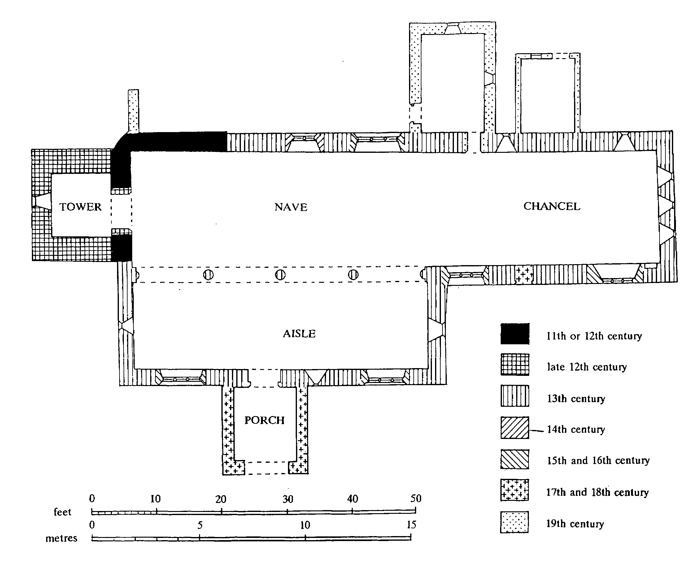
Ditton Priors: The Church of St. John the Baptist
By the early 15th century the church was dedicated to ST. MARY THE VIRGIN (fn. 421) but by 1831 to ST. JOHN THE BAPTIST. (fn. 422) The church, of rubble dhu stone and sandstone, consists of an undivided chancel and nave with north vestry, south aisle and porch, and a west tower topped by a shingled spire. (fn. 423) The north and west walls of the nave incorporate the oldest fabric, perhaps 12th-century or earlier. The slightly battered west tower, entered by a low arch, was added late in the 12th century. Early in the 13th century the church was almost rebuilt with the addition of a south aisle to the nave. The aisle has an irregular arcade of four bays and its original east and west lancets and one on the south survive; the chancel, rebuilt at or about the same time as the nave, has two lancets in the north wall, a group of three (badly restored) in the south wall, and a triple lancet east window. A blocked doorway in the south wall of the chancel may be contemporary with the rebuilding; one in the north wall probably gave access to an early vestry, perhaps that which existed in 1790. A two-light window was put into the north wall of the nave in the 14th century, and in the late 15th or early 16th century windows were put into the south wall of the chancel and the aisle and the north wall of the nave. The chancel screen is composed of panels of two 15th-century designs. (fn. 424) A screen across the centre of the aisle is presumably that which, in the 1830s, defined the chancel or chapel belonging to Ashfield manor. (fn. 425) The spire is probably of late medieval origin; the porch is probably post-medieval.
In the early 19th century the church had a gallery. (fn. 426) The spire was renewed c. 1832, (fn. 427) but the church was still partly clay floored and generally in a 'deplorable' state c. 1860 when restoration began under Stott. The work, completed c. 1871 in Wilkinson's time, included the construction of a new trussed rafter roof over both nave and aisle, and the church's reflooring, reseating, redecoration, and probably the restoration of many of the windows. It was probably then that the gallery was removed. Small grants for the work were received from the Hereford Diocesan Church Building Society in 1862 and 1866. A new vestry was built in 1894. (fn. 428) The spire was again renewed in 1978. (fn. 429) In 1983 a Lady chapel was made in that part of the aisle which had belonged to Ashfield manor. An oak communion table from Albrighton, near Shifnal, was acquired at the same time. (fn. 430)
Fragments of 15th-century woodwork, probably from a screen, are re-used in the pulpit and a desk front. The pulpit (with a reading pew) was moved in 1666 from an inconvenient position to the north-east corner of the nave, where it stood in the 20th century. (fn. 431) Two late medieval bench ends are re-used in the chancel, while the nave pews incorporate 17th- and 18th-century panelling, some dated 1666. Hangings include four 18th- and 19th-century commandment boards. (fn. 432) Two seats of c. 1714 and royal arms of 1814 were originally in Burwarton old church (closed 1877). (fn. 433) There are two chests, a wooden one of 1686 and an iron one of 1814 made by the Coalbrookdale Co. Memorials include an elaborate wall tablet with brass plate to Thomas Jenckes, vicar 1623–48, put up in 1667 by his son Thomas, a Shrewsbury goldsmith; (fn. 434) a fine iron floor slab to Ann (d. 1688) and Thomas (d. 1707) Hassall; and plain brasses of 1628 and 1733. There are hatchments for Gustavus Hamilton, Viscount Boyne (d. 1855), and Harriet his wife (d. 1854).
The church has a good range of fittings including four bells, one perhaps medieval and another of 1663 inscribed 'God save His Church Our King and Realm'. (fn. 435) The plate includes a secular Elizabethan cup given as a chalice in 1722–3. (fn. 436)
The parish register from 1583 survived in 1733, but by 1903 the registers were complete only from 1673. (fn. 437)
An additional burial ground west of the school was consecrated in 1932. (fn. 438)
There was a church or chapel at Middleton by the early 13th century; (fn. 439) its dedication is unknown but may possibly have been to St. Lawrence. (fn. 440) In the Middle Ages it was united with Deuxhill to form a rectorial benefice; (fn. 441) in 1277 the rector was accused of non-residence and his chaplain of failing to minister in the churches. (fn. 442) In 1291 Middleton and Deuxhill together were worth less than £4. (fn. 443) By 1331 Middleton chapel owed Wenlock priory an annual pension, apparently of 26s. from the great tithes, a due perhaps represented by an annual pension of 10s. owed to the priory from Middleton chapel c. 1523. (fn. 444) The union of Middleton chapel and Deuxhill, still in existence in 1505, was broken probably in 1515. The rector of Neenton was instituted to Middleton in 1521 but in 1532 the bishop reunited Middleton to Ditton Priors, in the patronage of Wenlock priory. About the same time Deuxhill was united to Glazeley rectory. Thus Middleton became, probably again, a chapel of ease to Ditton, whose vicar thus became responsible for the annual pension of 13s. 4d. to Wenlock priory. (fn. 445) In 1731 the vicar of Ditton was said to be endowed with Middleton chapel and the great tithes due to it from Middleton. (fn. 446)
In 1318 an indulgence of 30 days was offered to contributors to the fabric of the chapel and its bell turret (campanile). (fn. 447) The chapel stood at Middleton Baggot, (fn. 448) where a parcel of glebe was called Chapel close in 1841; (fn. 449) in 1625 the vicar's glebe had included the chapel yard at Middleton. (fn. 450) Last used for worship c. 1780, the chapel soon afterwards became a house. In its last years as a chapel it was a rectangular stone building with a small west bell turret and the scar of a chancel arch. By 1790 dormer windows (and so perhaps a second floor) had been inserted and a chimney had replaced the turret. (fn. 451) Two buildings stood near each other in Chapel close in 1841. (fn. 452) They were probably the former chapel and a dwelling house described in 1844 as adjoining it. (fn. 453) Both had gone by 1883. (fn. 454)
ROMAN CATHOLICISM.
There were at least four recusants in the parish in the 1590s, and the lord of the manor was one. (fn. 455) One parishioner refused to take the Protestation in 1642, (fn. 456) and there were 3 papists in 1676, 6 recusants in 1693. (fn. 457) From the 16th century the lords of the manor adhered to the old faith, (fn. 458) as probably did the Smallmans, tenants of their demesne, (fn. 459) whose faith suggests a connexion with the Smalmans of Wilderhope. (fn. 460) Middleton became a mass centre and by 1824 was served from Madeley. (fn. 461) In 1851 the chapel of St. Michael the Archangel on the top floor of Middleton Lodge had 50 free sittings and was served fortnightly from Aldenham, the Dalberg-Actons' seat. On Census Sunday 1851 36 people worshipped in the morning, 20 in the afternoon; 53 and 46 were said to be the average numbers. (fn. 462) The chapel was served from Bridgnorth from 1855 to the late 1940s, and thereafter by the Montfort Fathers, first from Brockhurst (in Church Stretton) and later from Ludlow. (fn. 463) In 1948 c. 30 attended a 'romantic and bucolic' Easter mass. (fn. 464) Attendance later dwindled, and mass was discontinued in 1973. (fn. 465)
PROTESTANT NONCONFORMITY.
William and Joyce Mayden and their servant were Anabaptists in 1663, (fn. 466) and in 1676 there were three protestant dissenters. (fn. 467)
By 1851 Methodism in the parish, with perhaps 200 or more people attending four meetings, had about thrice the adherents of the established church.
Wesleyans met in Ditton by 1801 (fn. 468) and perhaps by 1795. (fn. 469) They opened a chapel in the village in 1816. It had 100 sittings in 1851, and an average attendance of 80 was claimed for the afternoon service. The stone chapel, seating 120, closed between 1955 and 1971. (fn. 470)
In 1816 Primitive Methodists built a small stone chapel at the south end of Bent Lane. In 1851 it had an average attendance of 20 in the morning and 60–80 in the afternoon. There was seating for 90. By then there was also a Primitive meeting at Lower Netchwood, in the steward's house where most of the 28 seats were said usually to be occupied. The brick chapel, seating 33c. 1940, (fn. 471) was built in 1861. (fn. 472) The Bent Lane and Lower Netchwood chapels remained in use in 1984.
Wesleyans met in a house at Upper Netchwood in 1851, where 40 sittings were provided. An average of 25 then attended the morning service, 18 that in the evening. A small brick chapel seating 55 in pews was built c. 1865 and closed between 1940 and 1955. (fn. 473)
EDUCATION.
Ditton Priors was one of the parishes whose boys, having attended grammar school and being natives of Shropshire, had preference in the award of Careswell exhibitions (endowed 1689) at Christ Church, Oxford. (fn. 474)
In 1719 there was a school whose pupils had to attend church and learn the catechism. (fn. 475) In 1794 there was no endowed school, but a schoolmaster and two or three women taught school. (fn. 476)
By 1819 there was a school with 10 pupils, for which the vestry agreed to build a room in 1821. (fn. 477) Another opened in 1833 and had 10 girls in 1835, when the earlier school had 8 boys and there was a Roman Catholic school at Middleton. (fn. 478)
The curate built a school on the glebe in 1862, and in 1876 a new C.E. school (evidently successor to the curate's) began there. (fn. 479) It had 80 places (100 after enlargement in 1889) (fn. 480) and was supported by voluntary contributions and school pence. Government grant was probably earned from 1878. (fn. 481) Attendance averaged 59 in 1885, 85 in 1895, and 75 in 1913. (fn. 482) The school accommodated Liverpool evacuees and their teacher 1939–41 and Wallasey evacuees with theirs (acting headmistress 1944) 1942–4. (fn. 483) Gardening was introduced in 1941 and art and craft lessons were held in the parish reading room. (fn. 484) The school was Controlled from 1949 and much improved. (fn. 485) Thirteen-year-old pupils went to Burwarton C.E. school from 1949 and 11-year-olds to Bridgnorth Boys' and Girls' Modern schools from 1958–9. (fn. 486) A demountable classroom was erected in 1967 and 10 pupils with their teacher were admitted from the closed Middleton Priors R.C. (Aided) Primary school. (fn. 487) Ten pupils from the closed Monkhopton C.E. (Aided) Primary school were admitted in 1983. (fn. 488) The roll was 63 in 1932, 35 in 1950, 71 in 1978, and 61 in 1985. (fn. 489)
Francis Canning started a Roman Catholic school at Middleton in 1829–30 and succeeding lords of the manor were the school's patrons. The slate-roofed stone school, with schoolroom, had c. 60 places and, in 1835, 23 pupils; a teacher's house adjoined. (fn. 490) The founder's widow Jane left an endowment in 1852; (fn. 491) it yielded £26 3s. in 1875, more than 70 per cent of the school's income, the rest coming as voluntary contributions and school pence. The patron then gave books and equipment. (fn. 492) Government grant was earned from 1875 and drawing grant from 1892. (fn. 493) There was a Standard VI by 1883 and a Standard VII by 1888. (fn. 494) Exceptionally for a small rural school there were middle class pupils; they usually went on to Catholic boarding schools. (fn. 495) The school earned good reports after 1882 and the building was improved in 1883 and 1894. Attendance averaged 30 (the number of places in 1905), but overcrowding necessitated the schoolroom's extension in 1912. (fn. 496) Catholic pupils were normally a small minority. (fn. 497)
Liverpool and Birmingham evacuees were admitted in 1939, others from Wallasey in 1941. (fn. 498) By 1951 the building was very substandard and the infants had to use the (unoccupied) teacher's house. (fn. 499) The school became Aided in 1958, and the building was improved, but the old threat of closure continued. (fn. 500) Pupils aged 13 had transferred to Burwarton C.E. school in 1953, and 11-year-olds transferred to Bridgnorth Boys' and Girls' Modern schools in 1958–9. (fn. 501) Two pupils left for Bridgnorth R.C. (Aided) Primary school in 1966, (fn. 502) and the school closed in 1967 when the teacher and 10 pupils went to Ditton Priors C.E. (Controlled) Primary school. (fn. 503)
Night school was held in 1876–7 (fn. 504) and 1907– 8 (fn. 505) and county council classes in woodwork, horticulture, and livestock 1893–1901. (fn. 506)
CHARITIES FOR THE POOR.
By will proved 1700 Mrs. Catherine Barker left £5 a year charged on her estate; (fn. 507) in 1794 it was distributed in coal and bread but by 1820 in cash. By will dated 1723 Mrs. Dorothy Holland left £20 to be invested in land, the income to be spent on bread. In 1820 the income, 20s. a year, was distributed in cash with Mrs. Barker's charity. (fn. 508) In the later 19th and early 20th century the combined incomes, £6 a year, were usually distributed among c. 35 recipients, (fn. 509) but by 1975 they had not been received for several years. (fn. 510)