A History of the County of Stafford: Volume 7, Leek and the Moorlands. Originally published by Victoria County History, London, 1996.
This free content was digitised by double rekeying. All rights reserved.
A P Baggs. M F Cleverdon. D A Johnson. N J Tringham, 'Alstonefield: Introduction', in A History of the County of Stafford: Volume 7, Leek and the Moorlands, (London, 1996) pp. 1-8. British History Online https://www.british-history.ac.uk/vch/staffs/vol7/pp1-8 [accessed 18 May 2024].
A P Baggs. M F Cleverdon. D A Johnson. N J Tringham. "Alstonefield: Introduction", in A History of the County of Stafford: Volume 7, Leek and the Moorlands, (London, 1996) 1-8. British History Online, accessed May 18, 2024, https://www.british-history.ac.uk/vch/staffs/vol7/pp1-8.
Baggs, A P. Cleverdon, M F. Johnson, D A. Tringham, N J. "Alstonefield: Introduction", A History of the County of Stafford: Volume 7, Leek and the Moorlands, (London, 1996). 1-8. British History Online. Web. 18 May 2024, https://www.british-history.ac.uk/vch/staffs/vol7/pp1-8.
In this section
TOTMONSLOW HUNDRED (part)
ALSTONEFIELD
The ancient parish of Alstonefield lay in the north-east corner of the county, the river Dane forming the boundary with Cheshire and the river Dove that with Derbyshire. (fn. 1) It consisted of the seven townships of Alstonefield, Fawfieldhead, Heathylee, Hollinsclough, Longnor, Quarnford, and Warslow and Elkstones. With an area of 23,249 a. (9,409 ha.), (fn. 2) it was the second largest ancient parish in the county after Leek. Alstonefield village, in the south-east corner of the ancient parish, is 6½ miles north-west of Ashbourne (Derb.), the nearest town. For the northern part of the ancient parish the nearest town is Buxton (Derb.), 6 miles north-west of Longnor. Leek is 10 miles from both Alstonefield and Longnor.
The underlying rock is mainly sandstone of the Millstone Grit series. A large part of Alstonefield township and part of Warslow are on limestone, and parts of Heathylee and Quarnford are on Coal Measures. Stone is the usual local building material. The land rises to over 1,000 ft. in many places. Oliver Hill in Quarnford, at 1,684 ft. (513 m.), is the highest point in Staffordshire, and Flash, on the south side of the hill at 1,526 ft. (465 m.), is the highest village in England. In Heathylee the northern end of Morridge, a long ridge of moorland, reaches 1,535 ft. (468 m.), with the river Churnet rising on its western slope and the river Manifold and a tributary, Oakenclough brook, on the eastern slope. The land is given over mainly to pasture and rough grazing, and the farming is dairy and sheep, with most of the farms under 50 ha. in size.
In the south-east part of the parish there are numerous Bronze Age barrows. There was a church at Alstonefield before the Conquest, but it was Longnor which developed as the main settlement, with a chapel apparently by the 12th century and a market and a fair by 1293. There was evidently a chapel at Warslow by the 13th century. Place-names suggest that several sites in the parish were first occupied as outlying dairy farms, using pasture beside rivers and streams for grazing. In the early 14th century there were dairy farms on the manorial demesne in Fawfieldhead and Quarnford, and several others, called stalls, were held by tenants elsewhere in the parish. (fn. 3) Much of Heathylee seems originally to have been wooded, but farms had been established by the 15th century. There was a settlement at Flash in Quarnford by the late 16th century, and a church was built there in 1744.
Before the Conquest there were estates at Alstonefield, Stanshope, and probably Warslow. By 1086 Warslow had become part of Alstonefield manor, as had Stanshope by 1307. The manor covered the whole of the parish except for Upper Elkstone, most of which belonged to Trentham priory in the Middle Ages. (fn. 4) Alstonefield manor was divided into three shares in the late 12th century, and one of the shares was further divided into six in the late 13th century. Farms already in existence at the time of the first division were shared out. The rents of later farms and cottages were received jointly until 1566, when they were divided by lot. The profits of the manor court were also received jointly. (fn. 5) By the end of the 16th century all but one of the shares had been secured by the Harpur family of Swarkestone (Derb.) and later of Calke (Derb.), which in 1670 bought nearly all of the remaining share. The family changed its name to Crewe in 1808, and after 1844 it used the form Harpur Crewe, changing it to Harpur-Crewe in 1961.
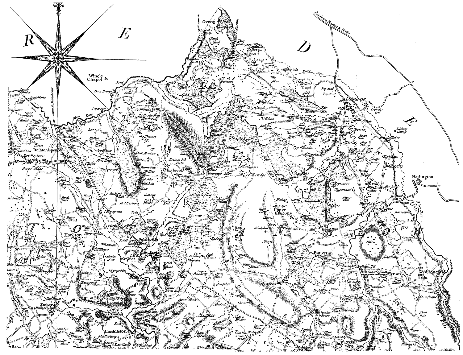
Yates's Map Of The County of Stafford 1775 (Part)
Scale Reduced To About 1 In. To 1¾ Mile (Approx. 1:110,000)
In the 1630s the parish was characterized by smallholdings, often under 50 a. and used mainly as pasture. There was also a large area of moorland waste, suitable for rough grazing. Alstonefield township had over three times as much farmland as waste, and Longnor twice as much; in Warslow the waste was only 100 a. in extent. In contrast, there were over 10,000 a. of waste in the other four townships and c. 6,000 a. of farmland. (fn. 6) Cottagers had been allowed to settle on the waste, which they improved at their own expense. (fn. 7) Encroachments continued, and in the later 18th century many cottagers who had extended their holdings paid only small rents or nothing at all. (fn. 8) About 1806 Sir Henry Harpur was advised not to disturb them. The policy of increasing rents as the cottagers' incomes grew had resulted in the settlement of a district 'which holds out as few natural temptations perhaps as any part of England'. (fn. 9)
In the 18th century many cottagers, especially in the area around Flash, worked as pedlars and hawkers, of whom there were c. 400 in Alstonefield parish in 1785. That year the government proposed the abolition of licensed hawkers, and a petition from those in Alstonefield helped to bring about a change of mind. John Lomas of Hollinsclough was a member of a small delegation of hawkers from the north-west of England which had an audience with the prime minister, William Pitt, and argued its case at the bar of the House of Commons. In a parliamentary debate in 1786 it was stated that hawkers in Alstonefield parish had converted 'a barren and wild spot to a rich and fertile circuit'. (fn. 10) Other cottagers around Flash in the late 18th and earlier 19th century became prosperous as button merchants, employing women and girls in the locality to make the buttons.
Coal deposits were worked in Heathylee by the early 15th century and in Quarnford by the later 16th century. Small-scale mining continued intermittently, the last mine, one at Quarnford, being closed in 1932. In the 18th and 19th centuries lead was mined at Warslow and copper at Upper Elkstone.
Until the early 19th century the Harpurs rarely visited Alstonefield, but in 1819, at the age of 24, Sir George Crewe, an Evangelical with a strong sense of social responsibility, succeeded his father. (fn. 11) He first visited his Alstonefield estate in 1819 or 1820, and he remarked later that he was probably the first head of his family who ever set foot there 'for any other purpose than shooting grouse'. He found the tenants '100 years behind the rest of the world, well disposed but ignorant and simple-minded'. Conditions were especially bad at Flash. (fn. 12) In 1830 Sir George built Warslow Hall, mainly for his agent but partly to provide occasional accommodation for himself and his family. Writing in 1831, he praised 'the bracing effect of the mountain air' and noted that he had become deeply interested in the area and would find much to occupy him if he visited regularly. (fn. 13) He duly turned his attention to the Alstonefield estate, having already had it surveyed in the later 1820s. (fn. 14)
In 1839, under an Act of 1834 amended in 1836, the remaining waste in the manor was inclosed together with the small acreage of open fields, over 3,000 a. in all. (fn. 15) Acknowledging the 'loss of the wild and picturesque character which the country formerly bore', Sir George justified inclosure with the argument that in a time of rising population 'no land which is capable of being cultivated can be allowed to be idle for gratification to the eye'. (fn. 16) The cost of inclosure and of repairing farmhouses was heavy, and in 1839 Sir George expressed the hope of discovering 'a rich vein of ore in some of the mines here by which we may be enabled to meet the urgent necessities'. (fn. 17) He also set about improving the education of his tenants, notably in partnership with William Buckwell, incumbent of Longnor from 1830. Longnor school was moved to a better site, Warslow school was enlarged, and the schools at Alstonefield and Flash were reorganized. Chapels and schools were built at Newtown and at Reaps Moor, both in Fawfieldhead, and at Hollinsclough.
Sir George died in 1844, and his successors took a less paternal interest in Alstonefield. Game shooting was resumed, and keeper's lodges were built in the early 1850s in Fawfieldhead and near Longnor. (fn. 18) Shooting rights were reserved when in 1951 the Harpur Crewe family sold 10,753 a. (4,351 ha.) of the farmland on its Alstonefield estate to pay death duties. (fn. 19) In 1986 the family's 4,629 a. (1,873 ha.) of moorland there passed in lieu of capital transfer tax to the Peak Park joint planning board, which manages it as the Warslow Moors Estate. (fn. 20) In addition the Ministry of Defence has occupied land since 1953 as a training area, 2,707 a. (1,095 ha.) in 1994 extending from the Leek-Buxton road in Heathylee nearly to Warslow village. The ministry owns 850 a. of it and leases 886 a. from the Peak Park joint planning board; it has a licence to train over the remaining 971 a. (fn. 21)
The scenery of the parish was attracting tourists by the earlier 19th century. (fn. 22) The whole of the parish became part of the Peak National Park on its creation in 1951. (fn. 23) The area remains popular with walkers, and there are a number of holiday cottages and second homes. Longnor was included in the Peak Park joint planning board's rural development scheme of the 1980s, which encouraged tourism and also the establishment of small businesses. In 1989 the first telecottage in the United Kingdom was opened at Warslow.
The Forest.
The townships of Fawfieldhead, Heathylee, Hollinsclough, and Quarnford lay in what was called the forest of Alstonefield in 1227. (fn. 24) The forest evidently existed by the 12th century: it was known variously as the forest of Mauban and Malbank Frith by the early 14th century, (fn. 25) from the Malbank family, lords of Alstonefield manor until 1176. The name Malbon Frith continued in use for an area which in the late 16th century consisted of 4,335 a. of waste. (fn. 26)
Peter the forester was a tenant of the manor in 1273. (fn. 27) In 1302 Philip Draycott held the bailiwick of the forest of Mauban, (fn. 28) and by the early 15th century the Beresfords of Beresford Hall held the office of forester of Malbon Frith. (fn. 29) The foresters who made presentments at the manor court by 1399 (fn. 30) were probably assistant foresters. Four presented in 1503, three in 1505, and two in 1506. (fn. 31) In 1608 Edward Beresford held two foresterships in Malbon forest. (fn. 32) By 1670 there was a tradition that there had been two officers of the Frith, a bowbearer living at Beresford Hall and a keeper living at Boosley Grange in Fawfieldhead. (fn. 33)
The lords' income from the forest in the 14th and 15th centuries included winter and summer agistment, turbary, passage tolls, and rents from tenants. (fn. 34) Such tenants were sometimes described as holding according to 'the custom of the manor of Frith'. (fn. 35) Malbon Frith was remembered in 1670 as having been stocked with deer. (fn. 36)
Manorial government.
In the mid 1270s the three lords of Alstonefield jointly claimed view of frankpledge and right of gallows. (fn. 37) A single court continued to be held for the whole manor, but jurisdiction was exercised only by the lords of the two main shares, although the perquisites were divided into three. (fn. 38) The court was held in 1530 in the name of the Blounts, lords of one of those two shares, and from 1545 in the name of Vincent Mundy, lord of both shares. (fn. 39) There was a separate court for Warslow and Longnor by the early 16th century. By 1697 the Alstonefield court was held at Hayesgate, in Fawfieldhead. It was still held there when last recorded in 1853. (fn. 40)
By the late 1390s there were five tithings in the manor, Alstonefield, Beresford, Forest, Longnor, and Warslow. (fn. 41) The Forest tithing, also known as Frith by the 1530s, covered Fawfieldhead, Heathylee, and Hollinsclough and sent two frankpledges to the view. (fn. 42) By 1594 Fawfieldhead was a separate tithing, and Heathylee and Hollinsclough together formed another. By 1697 Heathylee and Hollinsclough too were separate tithings. Quarnford seems not to have been in the Forest tithing, probably because it formed a separate manor in the Middle Ages.
There was mention of the three-weekly small court in 1329. (fn. 43) It was held at irregular intervals in the earlier 15th century but thereafter only rarely, being last recorded in 1529. (fn. 44)
The manor formed a single constablewick by 1377, (fn. 45) with a constable appointed at the manor court by the 1450s. (fn. 46) At that time appointments seem to have been made in respect of particular tenements, a practice followed in the early 18th century. (fn. 47) By 1595 the appointment of the constable was recorded both at the Alstonefield court and at that for Warslow and Longnor. (fn. 48) In 1698, when many thefts were going unpunished because victims were unable to bear the cost of prosecution, the constable was directed in future to prosecute thefts and to charge the cost in his accounts. At the same time it was noted that some constables had been presenting their accounts in 'dark and uncertain places' and spending large sums on such occasions. It was ordered that the constable was to present his accounts within a fortnight of leaving office at either Archford bridge or Hayesgate, those being the customary places; he was not to spend more than 20s. on the occasion. (fn. 49) A constable was still appointed in 1804. (fn. 50)
By the earlier 1370s there was a reeve for each of the two main shares of the manor. Two reeves were still appointed in 1475. (fn. 51) There was a hallswain for the manor by 1299. (fn. 52) In the earlier 1370s he received an annual stipend of 5s., reduced to 4s. by 1414. His duties included proclaiming the courts and presenting the deaths of tenants. The office still existed in 1495. (fn. 53) The court also appointed pinners and highway surveyors for the townships.
Parish government.
For taxing and rating purposes the parish had been divided into three parts by 1403. One consisted of Alstonefield township and was known as the part of the parish below Archford bridge, which spanned the Manifold on the boundary between the township and Fawfieldhead. The second part, known as High Frith, covered Fawfieldhead (including the detached Beresford area), Heathylee, Hollinsclough, and Quarnford. The third part consisted of Longnor, Warslow, and Lower and Upper Elkstone. (fn. 54) High Frith had been divided by 1611 into Low Frith, covering Fawfieldhead, and High Frith, covering Heathylee, Hollinsclough, and Quarnford. (fn. 55) All four became separate townships in 1733, having decided that year to relieve their poor separately. Longnor was a separate township apparently by the later 17th century, when it seems to have maintained its own poor. Warslow and the two Elkstones also seem to have been a separate township by then.
In 1553 Alstonefield church had two churchwardens, and there were two chapelwardens at Longnor and two at Elkstone. (fn. 56) By 1569 there were four churchwardens, two for Alstonefield church and one each presumably for Longnor and for Warslow and Elkstone, the arrangement by the early 18th century. (fn. 57) A parish clerk was mentioned in 1534 when William Hall of Stanshope left 5s. towards his wages. (fn. 58) In the late 16th century it was the custom for him to receive corn from the parish. (fn. 59) That was presumably the origin of the custom recorded in the 1740s whereby he received 4d. from every farmhouse in the parish and 2d. from every cottage; the payments were still made in 1841. (fn. 60) By 1725 he was also paid a wage of 13s. 4d. a year. (fn. 61) In addition he was paid for duties relating specifically to Alstonefield church. (fn. 62)
The whole of the ancient parish except Alstonefield township was included in Leek poor-law union at its formation in 1837 (fn. 63) and in Leek rural district in 1894. Alstonefield township was part of a Gilbert union until 1870 when it was added to Ashbourne union. It was in Mayfield rural district until 1934 when it was added to Leek rural district. (fn. 64) In 1974 the whole area became part of Staffordshire Moorlands district.