A History of the County of Gloucester: Volume 5, Bledisloe Hundred, St. Briavels Hundred, the Forest of Dean. Originally published by Victoria County History, London, 1996.
This free content was digitised by double rekeying. All rights reserved.
A P Baggs, A R J Jurica, 'Coleford', in A History of the County of Gloucester: Volume 5, Bledisloe Hundred, St. Briavels Hundred, the Forest of Dean, ed. C R J Currie, N M Herbert (London, 1996), British History Online https://www.british-history.ac.uk/vch/glos/vol5/pp117-138 [accessed 2 May 2025].
A P Baggs, A R J Jurica, 'Coleford', in A History of the County of Gloucester: Volume 5, Bledisloe Hundred, St. Briavels Hundred, the Forest of Dean. Edited by C R J Currie, N M Herbert (London, 1996), British History Online, accessed May 2, 2025, https://www.british-history.ac.uk/vch/glos/vol5/pp117-138.
A P Baggs, A R J Jurica. "Coleford". A History of the County of Gloucester: Volume 5, Bledisloe Hundred, St. Briavels Hundred, the Forest of Dean. Ed. C R J Currie, N M Herbert (London, 1996), British History Online. Web. 2 May 2025. https://www.british-history.ac.uk/vch/glos/vol5/pp117-138.
In this section
COLEFORD
The Parish and former market town of Coleford, 7 km. ESE. of Monmouth, was originally part of Newland parish. (fn. 1) Coleford formed a tithing occupying the north-east corner of the main block of the parish which, being created by assarting from the woodland and waste of the Forest of Dean, had many detached parts. (fn. 2) The town, whose name appears in the form Coverd or Cover in the late 17th century, (fn. 3) grew up in the centre of the tithing at a ford through which charcoal and iron ore were probably carried before 1282. (fn. 4) It had its own chapel by the late 15th century and it had emerged as the principal settlement on the west side of the Forest of Dean by the early 17th century. (fn. 5) The town's prosperity was enhanced by a grant of a market in 1661 and by the growth of the Forest's mining, ironmaking, and quarrying industries from the late 18th century. Coleford's population rose throughout the 19th century, and in 1894 the tithing was made a separate civil parish. (fn. 6) Detached pieces of Newland at Hoarthorns Farm, Lower Lydbrook, Reddings near Lydbrook, and Pope's Hill near Littledean, long regarded as parts of the tithing, (fn. 7) had been transferred to other parishes in 1883 and 1884. (fn. 8) In the mid 20th century Coleford ceased to have a market but after the Second World War new factories were built there to help to replace the Forest's traditional industries. The town, which continused to grow as a residential area, remained a shopping centre of local importance in 1994.
Coleford comprises 2,060 a. (c. 833.5 ha.) and is irregular in shape. It makes a substantial indent into the former extraparochial area of the Forest of Dean to the east and its boundary mostly follows ancient roads and tracks, including on the south-west routes from Highmeadow to Whitecliff and from Whitecliff to Millend and on the south routes over Mill hill and along Pingry Lane to the road from Chepstow (Mon.) to Coleford. The north-western boundary includes the course of Whippington brook. (fn. 9) This account of Coleford deals with the whole of the civil parish, apart from the Lane End district on the eastern boundary, which is treated below with the Forest of Dean, and land at Highmeadow on the west, which is treated below with Staunton. It includes that part of Whitecliff hamlet, on the south-west, which remained in Newland after 1894, and the detached part of Newland at Hoarthorns Farm, 210 a. (c. 85 ha.) north-east of Berry Hill, (fn. 10) which included part of Joyford hamlet and was transferred to West Dean township or civil parish in 1883. (fn. 11)
Coleford is in a basin surrounded by low hills, which rise to 225 m. in the north at Berry Hill, 220 m. in the east at Broadwell Lane End, and 215 m. in the south-west at Breckness Court. Apart from the north-west corner, where the land falls towards the valley of Whippington brook, drainage is to the upper part of Valley brook, which rises near Broadwell Lane End and flows in a valley bisecting Coleford from northeast to south-west. In 1282 Valley brook was called Thurstan's brook, (fn. 12) and later different parts in Coleford had different names, including Gout brook in 1769 for the section in the town (fn. 13) and Whitecliff brook for the section below it. (fn. 14) There was a royal fishpond on the brook on the west side of Pool green in the north-east in 1282. (fn. 15) It and a millpond recorded upstream of it in 1608 (fn. 16) were filled in after 1777. (fn. 17) The town grew up where two other streams joined Thurstan's brook, Coller (in 1769 called Coalway) brook rising near Edenwall, to the south-east, and Sluts brook near Crossways, to the northwest. (fn. 18) The problem of flooding was exacerbated in the early 18th century by water from mines above the town, (fn. 19) but the development of Speedwell colliery within the Forest in the later 19th century reduced the amount of water in Thurstan's brook to a trickle. (fn. 20) Coller and Sluts brooks were diverted and culverted as part of a flood prevention scheme carried out between 1979 and 1983. (fn. 21)
The carboniferous limestone on which Coleford lies contains deposits of iron ore and on the high ground of the north and east it is overlaid by the sandstone and shales of the Forest of Dean coalfield. Several productive coal seams, including the Coleford High Delf, outcrop in Coleford. (fn. 22) Iron ore, stone, and coal have been dug, and in several places, notably the area in the west called Scowles, the ground is riddled with abandoned mines and quarries. In some places the ground is covered by cinders, the slag produced by early ironworks. In the 20th century large-scale quarrying near Scowles and at Whitecliff produced two vast pits, which were both disused in 1994.
The process of assarting by which Newland parish was created was in progress in the later Coleford tithing by 1225, when Hugh of Kinnersley cleared land in the south-west corner on the estate later called Breckness Court. (fn. 23) Much land remained part of the Forest woodland and waste in 1282 when Thurstan's brook and the road to Broadwell marked the southern boundary of the Forest's Bicknor bailiwick. (fn. 24) Several landowners were required in the early 17th century to compound for their land as assarts made from the royal demesne. (fn. 25) Once cleared the land was usually cultivated in closes but an area at Scowles became a common. (fn. 26) In the late 18th century there were small scattered pieces of woodland in Coleford tithing including several in the north-west corner by Whippington brook, (fn. 27) where the Crown Commissioners of Woods planted over 200 a. of farmland between 1824 and 1827 to provide timber for naval use. (fn. 28) That woodland, forming part of the Highmeadow woods, was managed by the Forestry Commission from 1924, (fn. 29) and an area on the east side, at Berry Hill, was cleared to form the Christchurch holiday campsite, opened in 1939. (fn. 30) In the later 20th century the area of farmland was reduced further by the growth of housing and industrial estates outside the town centre, and golf courses were created at Edenwall and Five Acres, in the south-east and north-east respectively.
Several ancient routes in Coleford tithing fell into disuse after the town became the focal point of roads in the area. (fn. 31) The green way recorded in 1282 (fn. 32) was possibly part of a track running above the valley of Thurstan's brook and to the south-east of Scowles (in 1434 Greenway Scowles). (fn. 33) The track apparently became a way between Coleford and Newland church but, although a field on its route was known in 1792 as Church Path, (fn. 34) it was replaced long before 1608 by a road in the valley. (fn. 35)
Coleford town and Whitecliff hamlet, to the south-west, grew up on the valley road, which ran out of the Forest at Mile End to follow Thurstan's brook from Pool green, north-east of the town. The ford from which the town was named was presumably the crossing of Coller brook, where a bridge was built before 1608. (fn. 36) The road, of which the section between Mile End and Pool green was known in 1317 as the Derkesty (fn. 37) (later Dark Stile), (fn. 38) was an important route from Mitcheldean (fn. 39) and in the later 17th century traffic between Gloucester and South Wales used the section leading to the town. (fn. 40) At the south-west end of Whitecliff the road forked for Highmeadow and Millend and both routes have been used by travellers between Coleford and Newland village. (fn. 41) The Highmeadow road was the main route to Newland in the 16th century (fn. 42) and was used by travellers between Coleford and Monmouth in the early 18th century. (fn. 43) On the turnpiking of the road beyond Highmeadow in 1755 (fn. 44) it became the main coach road between Coleford and South Wales. (fn. 45) A road running from the Forest at Broadwell to a junction with the road from Mitcheldean at Pool green was known in 1317 as the pool way, (fn. 46) after the fishpond by the green. (fn. 47) That road, which originally continued west of the green and north of the town along Stank Lane, recorded in 1479, (fn. 48) became the road from Littledean and Newnham to Coleford (fn. 49) and in the later 18th century it was also used by travellers from Gloucester. (fn. 50)
An ancient route known in 1345 as the coal way ran north-westwards from the Forest boundary at Coalway Lane End and down Lord's hill to join the main road through Coleford east of Coller brook. (fn. 51) Known later as Coller Lane, (fn. 52) it was used by travellers from Blakeney and Purton passage on the river Severn in the later 17th century. (fn. 53) The road entering the south side of Coleford town was known as the ore way in 1306. (fn. 54) It was later the main route from Chepstow (fn. 55) and in the mid 18th century it was used by travellers between Bristol and Hereford, (fn. 56) who continued northwards from the town through Berry Hill where the road divided, within the Forest, for English Bicknor and Goodrich (Herefs.). (fn. 57) South of the town at High Nash, known in 1306 as Windbridge Ash, (fn. 58) the Chepstow road was joined by an old road from Whitecliff called Rock Lane and an old road from Milkwall, on the Forest boundary, (fn. 59) known in 1501 as Tufthorn Lane. (fn. 60) The road from Milkwall perhaps passed the place known as Put Oak's green in 1413. (fn. 61) Further south Pingry Lane, joining the Chepstow road at Perrygrove and known in 1608 as Breckness Court Lane, (fn. 62) provided a route from Clearwell village. The Staunton road branching from the Berry Hill road north of the town was part of the main road between Gloucester and South Wales in 1675 (fn. 63) but most traffic for Wales apparently took the road through Whitecliff in the 18th century. (fn. 64) In 1794, however, the road between Crossways, on the Staunton road, and Highmeadow, part of a route running across the north of Coleford from Five Acres, on the Forest boundary, was described as a public road to Monmouthshire. (fn. 65)
In 1796 the roads converging on Coleford town from Mile End, Broadwell, and Coalway and the road to Highmeadow by way of Whitecliff were turnpiked as part of a new Forest of Dean trust. (fn. 66) Edmund Probyn, a local landowner, was levying tolls at Scowles for the maintenance of the road to Highmeadow by way of Crossways in the later 1790s (fn. 67) but that road was administered by the Forest trust by 1824. (fn. 68) The Staunton road beyond Crossways came under the trust in 1831 when, on improvements to the road in Staunton village, it became the main Coleford-Monmouth road. (fn. 69) The road north out of Coleford town to Berry Hill, where tolls were collected in the later 1790s at its junction with the road from Five Acres to Highmeadow, (fn. 70) also came under the Forest trust in 1831 (fn. 71) but the Chepstow road south out of the town remained outside it. (fn. 72) In 1840 the trust had tollhouses at the junctions at Pool green, Crossways, Berry Hill, and the bottom of Whitecliff. (fn. 73) In 1841 a new turnpike was built, branching from the Mitcheldean road at Edge End, within the Forest, and running north of the town to the Staunton road at the Long stone, within Staunton, and it became the main Gloucester-Monmouth route. (fn. 74) The roads of the Forest trust were disturnpiked in 1888. (fn. 75) In 1991 a bypass road was opened south-east of the town running from the Coalway road below Lord's hill to the Chepstow road north of Perrygrove. (fn. 76) A junction between the Chepstow road and the bypass was formed east of High Nash and part of the old road south of High Nash was closed.
A tramroad opened in 1812 to link mines in the Forest with Redbrook and Monmouth entered Coleford north of Broadwell and, after crossing the Mitcheldean road north-east of Pool green, ran along the side of the valley of Thurstan's brook through the town and Whitecliff. The descent at Pool green was by means of an incline apparently controlled by ropes. (fn. 77) The tramroad was little used after Monmouth acquired a rail link to the South Wales coalfield in the mid 19th century and its track had been removed by 1880. (fn. 78) The first railway to reach Coleford, a branch line from Parkend opened by the Severn & Wye Railway Co. in 1875, ran through Milkwall to a goods and passenger station on the south-east side of the town. (fn. 79) A railway from Monmouth, using parts of the old tramroad route, was completed in 1883. It included a short tunnel at Whitecliff and it crossed the Newland road to run to a goods and passenger station next to that of the Severn & Wye Co. A junction was made between the two railways in 1884 after the Monmouth line had been taken over by the G.W.R. From 1916, when the Monmouth line closed west of Whitecliff, stone from the main Whitecliff quarry was carried by rail through Parkend (fn. 80) and in 1951 the junction at Coleford was improved. The Severn & Wye line, on which passenger services had ceased in 1929, (fn. 81) was abandoned in 1967 and the track between Whitecliff and Parkend had been removed by 1971. (fn. 82) Some railway buildings at Coleford, including a goods shed, were incorporated in a railway museum opened in 1988. (fn. 83) Also surviving in 1994 were the bridges which had carried the Monmouth railway across the Highmeadow road just beyond Whitecliff and the Newland road just outside the town and, on the Highmeadow road north-west of the railway bridge, the ruins of the bridge that had carried the Monmouth tramroad.
By the mid 14th century hamlets called Coleford and Whitecliff had grown up along the road in the valley of Thurstan's brook. Coleford, which had eight or more houses in 1349 (fn. 84) and was described as a street in 1364, (fn. 85) had a chapel by 1489. (fn. 86) The chapel stood on a rise at the south-western corner of a large open area west of Coller brook, and that area, triangular in shape with the main north-south route through Coleford at its western end, (fn. 87) became the site of a market in the mid 17th century. (fn. 88) A cross, perhaps that recorded in 1499, (fn. 89) stood north-east of the chapel in 1608. (fn. 90) In the early 17th century Coleford retained an essentially linear plan with several houses facing the later market place and many more in Newland Street, the road to Whitecliff, and, east of the Coller brook, in Gloucester Road, the road to Mitcheldean. The houses on the north-west side of Gloucester Road were in plots running down to Thurstan's brook. By the early 17th century much of High Street, the Chepstow road, had been built up and there were a few houses north of Thurstan's brook on the Berry Hill road, later St. John Street but in 1858 called Birmingham Street. There were also a few houses in an area known later as the Spout on the north-east side of a back lane, later Bank Street but in 1858 called Victoria Street, linking the road down Lord's hill with the Berry Hill and Staunton roads. North of the town a few houses stood on Sparrow hill, on the Berry Hill road, and a more continuous line extended along the north-west side of the Mitcheldean road to Poolway, (fn. 91) where a small outlying hamlet had been established by the late 15th century. (fn. 92)
Following the grant of a market in 1661 (fn. 93) much building took place within the town and c. 1710 it was reckoned to have 160 houses. (fn. 94) The market place was reduced by encroachments, notably a new market house built in 1679 on the site of the cross mentioned above. (fn. 95) In the late 1730s and early 1740s Viscount Gage tried by asserting manorial rights to prevent an enlargement of the chapel and other building in the town centre, (fn. 96) but encroachments continued and in several places streams were culverted and houses built over them. At the end of the century the fronts of houses and shops on the south-east side of the market place projected beyond that of the Plume of Feathers, which occupied part of the site of an inn opened before 1654. By 1800 also infilling had completed the building up of St. John Street. (fn. 97) In the late 18th century and the early 19th the town also expanded along its other streets and most of its older houses were rebuilt. Some new building was stimulated by the opening of the new tramroad in 1812, (fn. 98) and William Williams, a collier, built several houses on the north-west side of Gloucester Road before 1830. (fn. 99)
Among the older surviving buildings in the market place the Old White Hart, at the entrance to St. John Street, dates from the 17th century. The two adjoining cottages were rebuilt in the early 18th century for another inn (fn. 100) and a row of three houses at the entrance to High Street was built in the same period. Poolway House, at Poolway, has three bays dating probably from the late 16th century with a heavily timbered roof and, on the ground floor, a relocated plank and muntin wall. The house was enlarged westwards in the 17th century and extensively refitted in the 18th century. Many of the town's new fronts of the years 1795-1830 were to a uniform design with fluted keystones. The town's principal inn, the Angel on the north side of the market place, was refronted or rebuilt during that period. Of the town's few larger houses Bank House, on the north-east side of Bank Street, is pedimented and was probably built for James Coster before 1786. It was acquired by the Crown in 1861 as an office for the deputy gaveller of the Forest and it also housed a branch of the Gloucestershire Banking Co. from 1862; (fn. 101) it was the Forestry Commission's administrative headquarters for its Forest of Dean district in 1994. The town's larger houses of the period 1795-1830 include one on the south side of Newland Street, acquired by the industrialist James Teague (d. 1818) (fn. 102) and occupied as flats in 1994. Rock House, further down the valley and overlooking the street, was built north of the tramroad probably in the mid 1820s. In 1867 it was the home of W. H. Fryer, (fn. 103) who probably built the adjoining gothic folly later known as Rock Castle. (fn. 104) Lawnstone House, at the top of High Street, was in 1840 the residence of the solicitor William Roberts (fn. 105) and from 1927 the offices of West Dean rural district council, (fn. 106) which enlarged the building in the early 1950s. (fn. 107) Higher up at Cinder Hill, on the road to High Nash, Forest (formerly Tump) House was acquired by the metallurgist David Mushet in 1810 and became a hotel in the mid 20th century. (fn. 108) East of the town there were a few cottages on the Coalway road at Lord's Hill by 1777 (fn. 109) and a school and a parsonage house were built there in the late 1830s. (fn. 110) Further along the road a large building was erected in 1875 for Bell's Grammar school. (fn. 111)
Among changes in the town centre in the later 19th century, the market house (or town hall) was rebuilt on a larger scale in 1866 (fn. 112) and the chapel, which had been rebuilt in 1820, was pulled down in 1882, its tower being retained for a clock tower. (fn. 113) The most ornate building of the period was the Baptist chapel of 1858 in Newland Street, (fn. 114) and James Ward, the principal assistant of the deputy surveyor of the Forest of Dean, (fn. 115) added a new front to the house on Sparrow hill known by the late 1870s as Sunny Bank. (fn. 116) Most of the town's growth in the later 19th century was on the north-west side where the British Land Society laid out several new roads in 1858. Building on the estate, which had been enlarged by 1866, (fn. 117) included an entrance lodge of 1868 for a cemetery at the end of Victoria Road (fn. 118) and the parish church of St. John, consecrated in 1880, on a site in Boxbush Road overlooking the town centre. (fn. 119) Of the new houses on the town's outskirts, (fn. 120) the most prominent was the Coombs, built high up on the Berry Hill road in the late 1850s, in château style with a central tower, for Isaiah Trotter. It was a health cure centre in 1945 when the writers Laurence Housman and Vera Brittain were among visitors, (fn. 121) and later it was a home for the elderly, additional accommodation being provided c. 1980. (fn. 122)
The town's expansion after the First World War began on the south side where Coleford urban district council completed 20 pairs of new houses at High Nash in 1923. Between 1926 and 1928 the council built 30 houses in Albert and Victoria Roads, on the north-west side. (fn. 123) Most building in the mid 20th century was on the north side where the Sunny Bank council estate, originally comprising 50 houses built in 1940 and 1941 between the Berry Hill and Staunton roads, was enlarged after the Second World War. In the same period the road up Sparrow hill was closed and the Berry Hill road was diverted to leave the Staunton road further out. (fn. 124) From the 1950s there was considerable private building on the north-east side of the town (fn. 125) and by 1994 housing estates covered the land between the Coombs and Poolway. The area between Poolway and Lord's Hill, on the east side, was filled by piecemeal council and private development, beginning in 1960 with the Eastbourne council estate at Poolway. (fn. 126) In the late 20th century houses were also built on the south side of the town where the new bypass had attracted several small estates by 1994.
In the older part of the town new buildings in the early 20th century included two banks in the market place in the early 1920s (fn. 127) and a labour exchange on the Coalway road at the bottom of Lord's hill in 1937. (fn. 128) In the 1960s and 1970s several buildings were demolished to make way for new developments, which included a police station and magistrates' court, opened in 1964, on the south-east side of Gloucester Road. (fn. 129) Traffic congestion in the market place was eased by the demolition of the town hall in 1968 and the introduction of a gyratory system around the clock tower. (fn. 130) The top end of High Street was widened in 1970, the buildings on the east side being replaced by a row of new shops, (fn. 131) and in the later 1980s former railway land to the east was redeveloped to include a car park, a supermarket, and a small shopping centre. West of High Street new district council ofices were completed behind Lawnstone House in 1990, (fn. 132) and at Cinder Hill a doctor's surgery was built on a circular plan in 1993.
Whitecliff, a long straggling hamlet on the Newland road south-west of Coleford town, took its name from a rock face on the south-east side of the valley near the junction of Rock Lane. (fn. 133) It was called Whitecliff Street in 1275. (fn. 134) In 1349 it had 22 or more houses (fn. 135) and in the early 17th century it included several dwellings on the Highmeadow road beyond the junction of the road to Millend. (fn. 136) In the late 18th century cottages and small farmhouses were strung out along the Newland road (fn. 137) and by the mid 19th there was a cluster of cottages at the entrance to Rock Lane. (fn. 138) Whitecliff House, at the north-east end of the hamlet, was built in the early 19th century to the popular local design with fluted keystones. To the south-west Whitecliff Farm, part of an estate owned by the Revd. John Shipton in 1840, (fn. 139) was demolished c. 1935. (fn. 140) Near the south-west end of Whitecliff a mid 18th-century farmhouse, said to have been on the site of a house occupied by the Wyrall family until the later 15th century, (fn. 141) had fallen into ruin by the late 19th century and its site became a tip for spoil from a quarry in the mid 20th century. (fn. 142)
Several farmsteads were established on the high open land of the tithing, some of them before 1608, and several roads leading from the town were gradually built up, mainly with small cottages during the 18th and 19th centuries. In 1714 fifteen people were presented for building cottages on the Staunton road, (fn. 143) and by 1792 buildings were scattered along it almost to Crossways. (fn. 144) In the early 19th century several cottages were built in the Crossways area on the side of the road to Berry Hill, to the north-east, (fn. 145) and in 1908 a house called Rushmere was built on the Staunton road beyond Crossways. (fn. 146) Owen Farm, which stands south of Crossways and was bought by Ralph Owen (d. 1731), (fn. 147) is probably 17th-century in origin, but it has been extensively remodelled. It bears the crest of Edward Bell's charity, which bought it in 1823. (fn. 148) Scowles Farm, a plain stone farmhouse on the Crossways-Highmeadow road, was built shortly after 1674 on the site of a ruined sheephouse, acquired that year by the Probyn family of Newland, (fn. 149) and has been remodelled. Squatters built cottages on Scowles common from the start of the 19th century, (fn. 150) creating a hamlet with 36 households in 1851. The small community of miners and quarrymen (fn. 151) had its own church and school from the mid 19th century. (fn. 152)
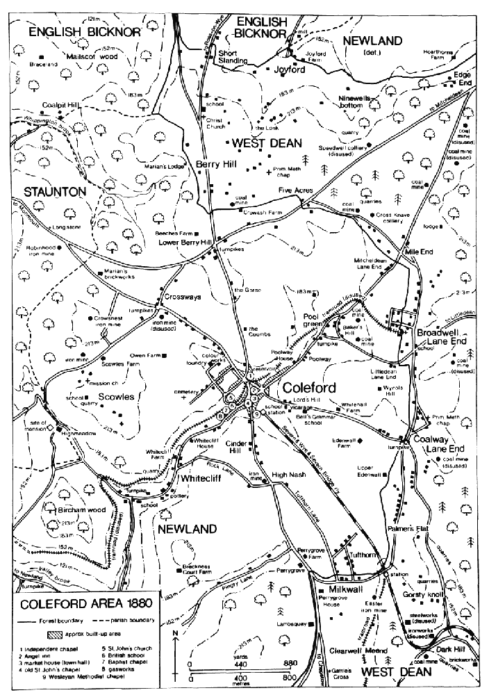
COLEFORD AREA 1880
North of Coleford there was a house on the Berry Hill road at the Gorse in the later 18th century. (fn. 153) Further north scattered building began close to the Forest boundary at Berry Hill before 1566. (fn. 154) In the late 18th century there was a cluster of houses, including several farmhouses, at the crossroads formed by the Berry Hill road and the road between Five Acres and Highmeadow (fn. 155) (later the main Gloucester-Monmouth road), and in 1851 there were 17 houses at Berry Hill belonging to Coleford tithing. (fn. 156) At the crossroads, sometimes called Lower Berry Hill to distinguish it from more extensive settlement on the extraparochial land of the Forest, (fn. 157) a farmhouse south of the Gloucester road was demolished in 1964 as part of a road improvement scheme. (fn. 158) To the west there was at least one dwelling in 1585 at the place called Knaven Green, and Beeches Farm, north-west of the crossroads, is on the site of a farmstead established by the late 16th century. (fn. 159) Marian's Farm, a small farmhouse further north, was recorded in the mid 18th century. (fn. 160) It was retained for use as a woodman's lodge by the Crown Commissioners of Woods when they planted the farmland there in the mid 1820s. (fn. 161) To the northeast, a farmhouse called Broomhill Farm was built next to Mailscot wood c. 1700, (fn. 162) but was abandoned on the creation of the new plantations; its ruins had been removed by 1840. (fn. 163) On the east side of Berry Hill the farmstead recorded at Crowash Farm, on the Forest boundary, from 1676 (fn. 164) was demolished in the later 20th century when more houses were built to the north. A farmhouse and barn standing next to the Forest at Five Acres were possibly built in the 17th century. In the mid 18th century there was also a cottage there (fn. 165) and in the 19th and 20th centuries several houses were built nearby, on the south side of the Monmouth road. Merryweathers (formerly Little Five Acres) Farm is on the site of a building recorded in 1608. (fn. 166)
Among the scattered farmsteads on the east side of Coleford the house at Folly Farm, on the Mitcheldean road beyond Poolway, was used as a barn by 1787. (fn. 167) Broadwell Farm, on the Forest boundary at the place once known as King's Broadwell, was recorded in 1789. (fn. 168) Whitehall, a small farmhouse on the Coalway road, was built in the late 18th century. At Wynols Hill, where a house was recorded in 1499, (fn. 169) a three-storeyed house built in the mid 17th century belonged to the Skynn family of Clearwell in 1699. (fn. 170) During the Second World War it was part of a prisoner of war camp (fn. 171) and soon afterwards it was demolished. (fn. 172) The main range of Edenwall Farm, standing in a valley below the Coalway road on the site of a house recorded in 1608, (fn. 173) incorporates a farmhouse and a barn. To the south-east a small 18th-century farmhouse or cottage on the Forest boundary, sometimes called Upper Edenwall, (fn. 174) was rebuilt after 1881. (fn. 175) There was at least one dwelling at Milkwall, on the Forest boundary south-east of Coleford, in 1628. (fn. 176) Of the farmsteads established near the boundary west of Milkwall possibly after 1608, (fn. 177) Perrygrove Farm, east of the Chepstow road, was known as Cover House and belonged to the Skynn family in 1727. (fn. 178) Much lower down Pingry Lane a medieval house called Breckness Court had been abandoned by the early 18th century when it was replaced by a farmhouse on a site above the valley. (fn. 179)
In the later 19th century several housing estates were developed to the east of Coleford by the British Land Society. The first, at Baker's Hill north-east of Poolway, (fn. 180) contained five houses in 1856. (fn. 181) The other estates, on the Forest boundary and including one at Tufthorn next to Milkwall, are recorded, together with 20th-century housing in the Lane End district, under the history of the Forest. (fn. 182) In the 20th century there was also much building north-west of Milkwall on Tufthorn Avenue (formerly Lane), where 46 council houses were built between 1929 and 1933 (fn. 183) and where the remaining land was filled with houses and industrial buildings after the Second World War. (fn. 184) In the 1960s several houses were built on the north side of the Coalway road as part of ribbon development extending from Coalway Lane End. (fn. 185)
Hoarthorns Farm, an isolated farmstead in the detached part of Newland north-east of Berry Hill, was held under English Bicknor manor in 1565 (fn. 186) and was part of the Eastbach estate by 1616. (fn. 187) The farmhouse was rebuilt in the early 19th century and was sold with some land in the mid 20th century. (fn. 188) To the west the small hamlet of Joyford in 1608 included cottages on both sides of the boundary between the detached part of Newland and English Bicknor. (fn. 189) Joyford Farm, a small house possibly of the 17th century, belonged to Newland (fn. 190) and was sold with part of the Highmeadow estate to John Hopkins in 1726. (fn. 191)
In 1672 seventy households were assessed for hearth tax in Coleford tithing (fn. 192) and c. 1710 the town contained 160 houses. (fn. 193) Between 1811 and 1831 the tithing's population rose from 1,551 to 2,193, the increase reflecting the growth in the coal industry. In the mid 19th century it increased more slowly and in 1871 it was 2,718. In 1901 Coleford civil parish had a population of 2,541, rising to 2,781 in 1921 and, after a small decrease in the 1920s, to 2,945 in 1951. Population growth accelerated in the 1950s and there were 5,075 inhabitants in 1991. (fn. 194)
A gas company formed in 1840 built its works in Newland Street (fn. 195) and supplied shops and houses in the town. Gas street lighting, delayed at first by lack of agreement among the townspeople, (fn. 196) was by 23 lamps in 1871. (fn. 197) The company, which also supplied White cliff, (fn. 198) was taken over by the Lydney gas company in 1946 and gas manufacture ceased at Coleford c. 1950, after nationalization. (fn. 199) Electricity was brought to the town by the West Gloucestershire Power Co. c. 1924. (fn. 200) In 1868 a volunteer brigade was formed to operate a fire engine brought to the town from Gloucester by an insurance company. (fn. 201) A brigade formed in 1931 became part of the county fire service in 1948. It was based on a station next to the rural district council's offices in High Street before 1964, when a new fire station opened on the east side of Cinder Hill. (fn. 202)
In 1821 Coleford had a dispensary supported by subscriptions and employing an apothecary or surgeon. It apparently closed through lack of funds, some people preferring to support the Monmouth dispensary. (fn. 203) There was a lack of burial space within the town and on the closure of Newland churchyard to burials of Coleford residents in 1867 (fn. 204) a burial board laid out a cemetery on the west side of the town. The cemetery, which included chapels for Anglicans and nonconformists linked by a corridor surmounted by a bellcot, opened in 1868 and was managed jointly by Coleford and Newland parish councils after 1894. It was enlarged in 1947 and the chapels were demolished in 1976. (fn. 205)
Coleford lacked basic sanitary services in the mid 19th century when the town's streams were used as sewers and water was taken from wells and from troughs alongside Thurstan's brook at the Spout. From 1873 a local board of health maintained a water cart, which had been acquired by subscription, and from 1877 it piped water from a small reservoir on the north-east side of the town to standpipes in or near the market place. That system, which in 1892 also served two houses, was extended to Whitecliff in 1899. Despite small schemes near Scowles and Berry Hill the higher parts of Coleford were without piped water until 1932 when water was supplied from a reservoir in Staunton in a joint scheme of the urban district council and West Dean rural district council. Pollution of the town's streams increased as the flow of water dwindled in the later 19th century and the unculverted sections of Thurstan's brook downstream in Whitecliff remained a nuisance in the mid 20th century. Between 1931 and 1935 the urban district council built sewers to replace surface gutters. (fn. 206) In the late 1940s and the early 1950s the West Dean council provided a sewerage system for the town with treatment works by Valley brook below Newland village. (fn. 207)
Coleford town probably had several victualling houses in 1600. (fn. 208) The number of public houses increased as the town grew in importance and in 1830 there were seven or eight inns, most of them in the market place, and a larger number of beerhouses. (fn. 209) On the north side of the market place the inn known as the Angel in 1725 had opened by the 1650s. For many years it housed an excise office (fn. 210) and in the mid 18th century it was the town's principal coaching inn and it was used for public meetings and assemblies. (fn. 211) A beam across the gap between it and the market house and bearing its name was taken down c. 1862. (fn. 212) Another inn open in 1654 (fn. 213) was an important meeting place in the later 17th century; (fn. 214) part of its site, on the south-east side of the market place, became a separate house in 1738 and the inn, then known as the Plume of Feathers, was called the Flower de Luce in 1752. The name had reverted to the Plume of Feathers, more commonly the Feathers, by 1784. (fn. 215) The north-west side of the market place had the Coach and Horses inn in 1719, (fn. 216) and the White Hart, which stood next to it in 1730, (fn. 217) was called the Old White Hart in 1787. The King's Head, opened at the east end by the entrance to Gloucester Road before 1785, (fn. 218) was a stoppingplace for a Gloucester and Monmouth coach in 1830 (fn. 219) and was the terminus of a Gloucester coach in 1849. (fn. 220) The sites of the Red Lion, mentioned in 1732, (fn. 221) and the Three Parrots, mentioned in 1755, (fn. 222) are not known. The Jovial Collier or Colliers, recorded from 1766, (fn. 223) and the Bear, opened by 1798 (fn. 224) and renamed by 1826 the Royal Oak and later the Lamb, (fn. 225) were in Gloucester Road. (fn. 226) The Red Lion mentioned in 1802 (fn. 227) was just outside the town at Cinder Hill. (fn. 228) In the 1840s and 1850s there were at least a dozen other public houses in the market place and the streets leading from it. (fn. 229) The Jenny Lind, recorded in 1856, (fn. 230) was at the Spout and was known as the Queen's Head in 1881. In 1881 there was also a coffee house in St. John Street. (fn. 231) The Angel, the Feathers, the Old White Hart, and the King's Head survived in 1994.
In Whitecliff the sign of the Folly, recorded in 1757, (fn. 232) belonged in 1851 to a beerhouse at the entrance to Rock Lane. (fn. 233) In the lower part of Whitecliff the Nag's Head, opened by 1790, (fn. 234) was known in the 1830s as the Traveller's Rest (fn. 235) and was the hamlet's only public house in 1910. (fn. 236) It closed after 1935. (fn. 237) In 1861 there was an inn at Crossways and several other public houses in the north part of Coleford tithing. The Cross Keys, at the Lower Berry Hill crossroads, (fn. 238) was presumably that called the New Inn in 1856. (fn. 239) An inn there in 1994 was called Pike House.
A friendly society was meeting at the Jovial Collier in 1766. From 1777 many similar societies meeting at inns in and near the town had their rules enrolled (fn. 240) and in 1807 Coleford had 11 benefit societies with an average membership of 100. The largest, meeting at the Angel, had 223 members. (fn. 241) A savings bank was established in the town in 1838 (fn. 242) and an equitable and industrial society, presumably a co-operative venture, had been formed by 1889. (fn. 243) There was a circulating library in the town in the late 1840s (fn. 244) and a mechanics' institute founded in 1855 opened a reading room and library there. The institute, reorganized in 1859, closed in the early 1860s (fn. 245) and the town had a privately owned reading room in 1863. (fn. 246) In the 1930s a library was run from a stationer's shop. (fn. 247) A branch of the county library at Cinder Hill in 1959 (fn. 248) was later housed in a former chapel in High Street and in 1964 moved to new premises in Bank Street. (fn. 249) The market house of 1679 also served as a town hall and remained an important meeting place until its demolition in 1968. (fn. 250) Among groups using it in the late 1860s was a masonic lodge. (fn. 251) A community centre built in Bank Street in 1967 was enlarged in 1979. (fn. 252) Other meeting places in 1994 included the wooden Maycrete Hall, built at Cinder Hill c. 1930 as a centre for the unemployed. (fn. 253) A drill hall built in High Street in 1906 was converted a few years later as a cinema, (fn. 254) which remained open, under the name of the Studio, in 1994. The town had a brass band in 1864. (fn. 255)
In 1831 a printing press was set up in Coleford (fn. 256) and from the early 1860s several weekly newspapers for the Forest area were printed in the town. The most successful was the Dean Forest Guardian, started in 1874 as a Conservative publication. (fn. 257) It was printed at Cinderford from 1922, when it came under the same ownership as papers in Cinderford and Lydney, (fn. 258) and publication ceased in 1991, when the three papers were amalgamated under the title of the Forester. (fn. 259)
Sports clubs in Coleford included the Forest of Dean cricket club founded before 1842. (fn. 260) Coleford's first rugby football club was formed in 1877 and association football and hockey clubs were also formed before the First World War. For many years the August fête of a branch of the Ancient Order of Foresters was a major athletics event. (fn. 261) In 1919, to honour the award of the Victoria Cross to Angus Buchanan, a local man, land on the west side of the town was purchased by public subscription for a recreation ground. (fn. 262) It included a playing field, a bowling green, and tennis courts; the courts were abandoned before 1980. (fn. 263) Another playing field was laid out some way north-west of the recreation ground in the late 1930s. (fn. 264) A golf club founded in 1907 (fn. 265) had links between High Nash and Whitecliff; (fn. 266) they were ploughed up during the Second World War. (fn. 267) In the early 1970s the former Bell's Grammar school at Lord's Hill was converted as a country club and, in 1973, the adjoining farmland at Edenwall was laid out as a golf course. (fn. 268) In 1994 another golf club had a new course in the north-east of Coleford, extending from the Mitcheldean road to Five Acres.
In 1643 royalist troops marching on Gloucester from South Wales dislodged a parliamentary garrison stationed at Coleford to intercept them. (fn. 269) Natives of Coleford have included the writer Mary Howitt (1799-1888) (fn. 270) and the metallurgist Robert Mushet (1811-91), who by experiment in a barn on the town's outskirts discovered a refinement of the Bessemer process. (fn. 271)
MANORS AND OTHER ESTATES.
As land in Coleford was cleared for settlement in the Middle Ages a number of estates were formed. Some, notably Breckness Court, owed chief rents to the royal manor of Newland, part of the St. Briavels castle estate. (fn. 272) In 1275 at least one house, in Whitecliff, was held from William Ely the younger for a cash rent, suit of court, and heriots, (fn. 273) and in 1349 John Joce of Newland received chief rents from houses and lands in Coleford and Whitecliff. John's successors, owners of the Clearwell estate, (fn. 274) continued to take rents in Coleford and Whitecliff in 1462. (fn. 275)
The BRECKNESS COURT (formerly BRECKNOCKS COURT) estate in the southwest corner of Coleford tithing (fn. 276) originated as an assart which Hugh of Kinnersley created under grant from the Crown before 1225. (fn. 277) The estate, which was styled a manor from the early 17th century, (fn. 278) was restored to Hugh in 1233 after seizure for the Crown. (fn. 279) It passed to John of Kinnersley, who held 151 a. from the Crown for 44s. 5d. rent and was succeeded c. 1255 by his son Hugh, a minor. (fn. 280) In 1277 Hugh of Kinnersley sold the estate to Richard de Carew, bishop of St. Davids, (fn. 281) who died in 1280 (fn. 282) having settled the reversion of a messuage, 3 ploughlands, and rents worth 73s. 4d. in Newland on Erneburga, wife of Thomas of Brecon. (fn. 283) In 1319 Erneburga and her then husband John ap Howel granted that estate to John's son Howel and in 1343 Howel settled it on himself and Maud la Kele and entailed it on her children Robert and Catherine. (fn. 284) Richard Aubrey was the lord of Breckness Court in 1366. (fn. 285) The estate's descent has not been traced during the next two centuries. In 1585 Walter Jones lived on it, (fn. 286) and in 1608 it belonged to Thomas Jones and Hugh Jones, (fn. 287) who in 1623 were described respectively as of Llanwarne and Little Dewchurch (both Herefs.). (fn. 288) In 1635 Thomas's son Edward had an interest in the estate (fn. 289) and in 1707 William Jones and others, among them Penelope the widow of Edward Jones (d. 1685), conveyed a moiety of it, known as Breckness Court farm and including the site of the main house, to John Symons of Clearwell. (fn. 290) The other moiety was owned in 1692 by Thomas Jones (fn. 291) of Little Dewchurch and sold in 1710 by his widow Rachel and daughter Lettice, the wives of Benjamin Mason and Richard Oswald respectively, to William Davies. It comprised land on the south-east side of Pingry Lane, in Clearwell tithing, (fn. 292) and its descent has not been traced. From John Symons (d. 1721) Breckness Court farm descended with the Symons family's lands elsewhere in Newland parish until the break-up of that estate in the late 19th century (fn. 293) and was acquired before 1894 by E. R. Payne. (fn. 294) The Payne family had 54 a. at Breckness Court in 1910 (fn. 295) and owned land there in the 1940s. (fn. 296)
In 1225 the Crown gave Hugh of Kinnersley five oaks to build a house on his estate. (fn. 297) Known in 1334 as Kinnersley Court and in 1358 as Brecknocks Court, (fn. 298) it stood on a moated site north of Pingry Lane (fn. 299) and was probably occupied as a farmhouse in the early 17th century. (fn. 300) The site, in 1840 part of a field called Moat meadow, (fn. 301) had been abandoned by c. 1711 when John Symons converted a barn on higher ground some way to the north as a farmhouse. (fn. 302) That house was abandoned long before 1985 (fn. 303) but it was standing as part of a range of farm buildings in 1994.
Land in Coleford belonging to Staunton manor presumably once formed part of the Staunton bailiwick of the Forest. (fn. 304) In 1345 Philip, son of John of Staunton (d. 1339), made a grant of lands in Coleford, (fn. 305) and in 1413 the lord of Staunton owned land at Edenwall. (fn. 306) In 1478 the lord of Staunton's possessions in Coleford were said to include 100 a. and to be held from Flaxley abbey but in 1526 they were held from the St. Briavels castle estate. (fn. 307) In 1579 Staunton manor included land and chief rents in many parts of Coleford, including Tufthorn, Lord's Hill, and Edenwall. (fn. 308) Other chief rents from houses and land at Whitecliff and elsewhere were acquired from Charles Thornbury by William Hall of Highmeadow in 1589, (fn. 309) and passed with the rights of Staunton manor from 1620. In the 18th century claims of the Gage family, owners of the Highmeadow estate and lords of Staunton, (fn. 310) over Coleford, particularly over the town's market place, caused conflict with local people and with the earls of Berkeley, lessees of the royal manor of Newland. (fn. 311) The Crown, which owned Staunton manor from 1817, (fn. 312) sold several small strips of land in the market place in 1866. (fn. 313)
Flaxley abbey, which made a grant of land in the north-west quarter of Coleford in 1430, (fn. 314) received rents in Newland, Coleford, and Staunton valued at £17 3s. 6d. in 1535. (fn. 315)
ECONOMIC HISTORY.
Agriculture.
Much of Coleford was held by free tenants owing chief rents to the royal manor of Newland, (fn. 316) the rents being determined when the land was cleared or in the early 17th century when the owners made compositions with the Crown. (fn. 317) In the 14th and 15th centuries many houses and small holdings owed chief rents to the Joce family and their successors to the Clearwell estate. (fn. 318)
In the later Middle Ages a large part of Coleford was meadow land, including in 1478 land at Pool green. (fn. 319) Arable land, which on the Breckness Court estate in the south-west corner of the tithing evidently comprised 3 ploughlands in 1278, (fn. 320) included a small open field on the hillside at High Nash in 1344. (fn. 321) In the later 15th century there were several other small open fields on the hills in the south part of Coleford, the field called Ducknells being high above Whitecliff. Holdings in the fields were described in terms of 'day-works', the number of days needed presumably for ploughing. (fn. 322) Along with freeholders elsewhere in the parishes bordering the Forest of Dean, Coleford's landholders enjoyed common rights on the royal demesne land of the Forest. (fn. 323) On the west side of the tithing Scowles common, (fn. 324) covering 23 a. in 1792, was used by local people in the later 18th century for grazing sheep during the months the Forest was closed to livestock. Ownership of the common, claimed at that time for Newland manor by the lessee of the St. Briavels castle estate, was confirmed to the lord of Staunton manor in 1798. (fn. 325) There was a new sheephouse at Wynols Hill in 1654. (fn. 326) An older sheephouse north-east of Scowles was in ruins in 1674. (fn. 327) Hops were grown in the tithing before 1618, (fn. 328) and in the early 18th century several orchards near the town grew cider apples of the variety called stire. (fn. 329) There were also orchards on Hoarthorns farm, north-east of Berry Hill, in 1796. (fn. 330)
In the late 18th century much land in Coleford was worked by tenant farmers. By 1792 most of the farmland at the north-west end of the tithing had been incorporated in two farms on the Highmeadow estate, both held by leases renewed in 1793 for 16 years. Broomhill farm had 142 a., including 56 a. to the north-west at Braceland in English Bicknor, and Marian's farm 140 a., including 16 a. in Staunton and 21 a., formerly a separate farm, at Knaven Green. On the same estate a farm of 19 a. at Whitecliff had been added to Cherry Orchard farm (in Newland and Staunton), and a tenant at will farmed 26 a. at Lower Berry Hill. There were half a dozen other farms, all with under 50 a., in the north-west quarter of Coleford in 1792. They included Scowles farm, which was part of the Probyn family's estate, Owen farm, and Whitecliff farm. (fn. 331) In the south part of the tithing in 1814 Breckness Court and Perrygrove farms, on the Symons family's estate, contained 65 a. and 64 a. respectively; (fn. 332) Breckness Court had been tenanted before 1712. (fn. 333)
The area of farmland in Coleford was reduced in the mid 1820s when new timber plantations were created in the north and Broomhill and Marian's farms were lost. (fn. 334) In 1840 Coleford contained 17 farms of over 20 a. The largest were Edenwall (123 a.), Whitecliff (106 a.), Pingry (92 a.), and Five Acres (83 a.). At that time the detached part of Newland north-east of Berry Hill contained Hoarthorns farm (176 a.), which was part of the Eastbach estate in English Bicknor, and a small farm at Joyford. (fn. 335) In 1896 a total of 69 agricultural holdings was returned for Coleford parish, most of them worked by tenants. (fn. 336) The number of farms declined in the 20th century. Thirty-nine, all under 100 a. and most under 50 a., were returned in 1926, when farming provided regular work for 32 people. (fn. 337) From the late 1950s the area of cultivation contracted as land was taken for industrial, residential, and recreational use, (fn. 338) and in 1988, when most farmland was owner-occupied, 19 holdings were returned for the parish. One farm had more than 100 ha. (247 a.), but most of the others had less than 20 ha. (49 a.) and were worked on a part-time basis. (fn. 339)
In the mid 19th century a greater area of Coleford was devoted to arable than to grassland. (fn. 340) The main crops were wheat, barley, grass seeds, and turnips, and in 1866 the arable land, 1,068 a., included 120 a. lying fallow. At that time 794 a. were permanent grassland and beef and dairy cattle and pigs were kept as well as much larger numbers of sheep. (fn. 341) In the later 19th century the numbers of beef and dairy cattle grew, and the move from arable to livestock farming continued in the early 20th century, when the sheep flocks were enlarged. In 1926, when 1,102 a. were returned as permanent grassland and only 117 a. as arable, the number of sheep was 2,305 compared with 1,152 in 1866 and the numbers of beef and dairy cattle 165 and 121 compared with 92 and 50 in 1866. There was at least one commercial poultry farm in Coleford in 1926. (fn. 342) During the Second World War the size of the dairy herds increased (fn. 343) but in 1988, when most of Coleford's farmland remained under grass, the principal farms were devoted to sheep and beef farming. (fn. 344)
Mills And Ironworks.
In 1594 Charles Thornbury quitclaimed to Thomas Baynham a mill (fn. 345) on Thurstan's brook at Pool green. It was held in 1608 by William Thornbury (fn. 346) and was possibly the corn mill owned in 1667 by Thomas Foley of Great Witley (Worcs.). (fn. 347) Another building at Pool green in 1608, downstream of William Thornbury's mill and on or below the dam of the king's fishpond, (fn. 348) was evidently the corn mill bought by Benedict Hall of Highmeadow in 1637. (fn. 349) Nothing is known of the mills above the town after the mid 17th century.
The site of the highest mill on the brook below the town was occupied in 1840 by a building called the old mill. (fn. 350) Downstream a grist mill operating in Whitecliff in 1694 (fn. 351) may have been the mill near the centre of the hamlet in 1792 at the site of the later ironworks. (fn. 352) During the Napoleonic Wars a mill next to the ironworks made black paint from yellow ochre. (fn. 353) It was worked by Isaiah Birt, one of the ironworks' owners, who in 1806 obtained a patent for the manufacture of black paint, and it remained in use until 1813 or later. (fn. 354) In 1618 William Worgan owned a mill at Whitecliff cross, (fn. 355) at the south-west end of the hamlet, where Elizabeth Worgan held a grist mill under a grant from William Probyn of Highmeadow in 1657. (fn. 356) That was probably the Whitecliff mill belonging to the Highmeadow estate in 1675 and 1707. (fn. 357) A steam mill at Whitecliff, apparently started c. 1820, (fn. 358) was in use in the mid 1850s. (fn. 359) None of the mills below the town was in use in 1880. (fn. 360) The location of a water mill on the Breckness Court estate, demolished before 1673, is unknown. (fn. 361)
Ironworking in Coleford in the Middle Ages or earlier produced large quantities of waste material or cinders. (fn. 362) Some formed prominent mounds, of which several were in the north-west part of the tithing towards Staunton. (fn. 363) The earlier ironworks were evidently moveable forges operating on the royal demesne woodland of the Forest of Dean. (fn. 364) An oresmithy, or furnace, was operating at Whitecliff in 1361, (fn. 365) and the hamlet had a number of furnaces and forges in the 15th and 16th centuries. (fn. 366) In the later Middle Ages iron was also worked in Coleford town, (fn. 367) where there was a furnace next to the chapel in 1539. (fn. 368)
In 1797 James Teague, a local mine owner, formed a partnership with Midland industrialists including Samuel Botham of Uttoxeter (Staffs.) to build a coke-fired furnace at Whitecliff. After flooding halted construction work Teague's company was re-formed with Thomas Halford, a London stockbroker, as a member and the furnace, near the centre of the hamlet, was blown in probably in 1801 or 1802. A second furnace was built beside it before 1808. (fn. 369) The ironworks supplied tinplate works but their output was limited by the quality of coke used. In 1809 Halford, who had taken over the ironworks, enlisted the help of David Mushet, a noted metallurgist, to increase productivity but the works remained unprofitable and Mushet withdrew from the venture after a few months. The furnaces were abandoned several years later, perhaps by 1812, and Halford was declared bankrupt in 1816. Some of the fittings were sent to Cinderford in 1827, (fn. 370) and the surviving ruins were maintained for their archaeological and industrial interest in the late 20th century. (fn. 371)
Other Industry And Trade.
The exploitation of Coleford's mineral resources began long before 1397 when its first known miner was recorded. (fn. 372) Ancient surface iron mines known locally as scowles gave the name to the limestone outcrop in the west of the tithing. Generations of Newland parishioners also quarried stone at Scowles, which in the mid 18th century was riddled with abandoned workings. (fn. 373) Coal was presumably dug on the higher ground in the east part of Coleford by the late 16th century, when a miner acquired a lease of land bordering the royal Forest at Broadwell. (fn. 374) Six miners were listed in Coleford in 1608. (fn. 375)
By the late 17th century iron-ore mining had been abandoned in favour of the digging up of cinders left by early ironworks. The owners of the Highmeadow estate exploited cinder deposits by the Staunton road and in the 1720s supplied cinders to the Redbrook furnace. Cinders were also quarried at Cinder Hill and, in the 1760s, in the town and at Whitecliff. (fn. 376) The building of the Whitecliff ironworks stimulated ore prospecting in the early 19th century, notably by David Mushet who in 1809 developed Boxbush mine near the town centre. (fn. 377) In 1835 ore was mined north of Scowles, between Whitecliff and High Nash, and at Perrygrove. In the early 1870s Scowles pit, by the CrosswaysHighmeadow road, sent ore to the Parkend ironworks, (fn. 378) and Crowsnest pit, to the north, supplied ironworks in South Wales. (fn. 379) Crowsnest mine later yielded a quantity of yellow ochre. (fn. 380) In 1873 two pits were opened at Crossways but they and several new iron-ore mines at High Nash were abandoned not long afterwards. Two drift mines at Whitecliff extracted small amounts of ore in the later 1890s. (fn. 381)
Coal mining continued in the north and east parts of Coleford from the 17th century. (fn. 382) In the east a mine, known in 1735 as Gentlemen Colliers, (fn. 383) included a working pit at Littledean Lane End near Broadwell in 1835. At that time there were also working coal mines in the Poolway and Berry Hill areas, some of the pits north of Poolway belonging to Cross Knave colliery. Although coal mining declined in Coleford after 1850, when new pits were opened within the Forest, (fn. 384) there were several pits and levels on the east side of the tithing in the later 19th century (fn. 385) and mining continued at Poolway until the 1960s. (fn. 386) The principal colliery owner there employed 45 men in the early 1940s. (fn. 387) Coal was also mined north of the town in the 1940s and the opencast method was used to extract coal at the Gorse and at Edenwall in the 1960s. (fn. 388)
A marl pit recorded in 1354 (fn. 389) may have been in Coleford tithing. Limestone was quarried at the south-west end of Whitecliff before the 17th century. (fn. 390) One of the two grindstone hewers listed in Coleford in 1608 (fn. 391) worked at Bixhead, in the Forest, in 1621. (fn. 392) In the 18th century residents of Whitecliff and Berry Hill worked as stone cutters. (fn. 393) Limekilns operated at Whitecliff, (fn. 394) and Scowles, where a kiln was built before 1734, supplied much lime to Monmouthshire. In the later 18th century Viscount Gage, who claimed manorial rights at Scowles, opposed the building of new kilns there, but a kiln erected in 1793 under a grant from the St. Briavels castle estate was rebuilt after it had been pulled down on Gage's orders. (fn. 395) In the late 18th century lime was also burnt on Hoarthorns farm, north-east of Berry Hill. (fn. 396) The opening of the Monmouth tramroad in 1812 (fn. 397) stimulated quarrying at Whitecliff and there were three new limekilns at the south-west end of the hamlet in 1836. (fn. 398) The quarries on the west side of the Forest offered additional jobs to Coleford men (fn. 399) and in 1851 G. E. Payne, a Coleford stone merchant, had nine employees. (fn. 400) At Whitecliff, where lime burning continued intermittently, (fn. 401) a quarry on the north side of the valley was worked for roadstone in 1870 (fn. 402) and was enlarged after the construction of the Monmouth railway. It later sent stone by rail through Coleford and Parkend (fn. 403) and by the mid 1960s it formed a massive crater reaching into the hillside as far as Scowles. (fn. 404) Several quarries were worked at Scowles in 1870. (fn. 405) A quarry opened to the north-west, between the Crossways-Highmeadow road and the parish boundary, in the late 19th century (fn. 406) was exploited for roadstone (fn. 407) and in the later 20th century it ate deeply into the hillside. (fn. 408) Both it and the Whitecliff quarry were idle in 1994.
Iron was worked in Coleford and Whitecliff in the later Middle Ages, (fn. 409) and among the metal trades established before 1333 was nailmaking. (fn. 410) A sharesmith lived in Coleford in 1387 (fn. 411) and one of the more prosperous residents in 1534 was an iron merchant. (fn. 412) In 1608 metal trades in the tithing were represented by 4 smiths and 2 nailers and other trades by 4 carpenters, 1 cooper, 3 shoemakers, 2 tailors, 2 butchers, 3 tanners, 2 glovers, and 2 weavers. (fn. 413) While some of those tradesmen presumably lived at Whitecliff, where there was a tannery in the 17th century, (fn. 414) and some possibly in the detached part of the tithing at Lydbrook, the retailing trades centred on Coleford town where residents included a chandler in 1640 (fn. 415) and a mercer in 1658. (fn. 416)
Following the grant of a market in 1661 (fn. 417) the town's economy depended both on market trade and on retail business, and in the early 18th century its community of small shopkeepers and innkeepers relied on the custom of miners from the surrounding countryside. (fn. 418) Shopkeepers in 1751 included an ironmonger, (fn. 419) and the three shops on the Highmeadow estate in 1756 were presumably in the town. (fn. 420) A brewery was recorded in Coleford in 1686 (fn. 421) and there were several small malting businesses in the town in the 18th century. (fn. 422) A silkweaver lived there before 1727. (fn. 423) From the later 17th century Coleford also provided opportunities for professional men. Surgeons were recorded from 1702 (fn. 424) and an apothecary lived in the town in 1751. (fn. 425) At least one attorney practised at Coleford in 1700 (fn. 426) and among resident attorneys in 1745 was Thomas James. (fn. 427) James, later of Rodleys, in Lydney, (fn. 428) was agent of the St. Briavels castle estate and his practice remained in his family (fn. 429) until William Roberts acquired it in 1829. (fn. 430)
Although Coleford was on an important route between Gloucester and South Wales (fn. 431) road traffic was of minor importance for the town's economy in the mid 18th century. (fn. 432) Improvements to roads in the Forest in the late 18th century increased traffic through Coleford (fn. 433) but from 1841 the town was bypassed by the Gloucester-Monmouth road. (fn. 434) In the late 1840s there was a thrice-weekly coach service between Coleford and Gloucester (fn. 435) and in the mid 1850s a daily service to the railway at Lydney was started. (fn. 436)
With the expansion of mining and quarrying in the Forest from the later 18th century (fn. 437) Coleford grew in importance as a market and business centre for the area. In 1830 its shopkeepers included 5 grocers and drapers, 2 linen drapers, a grocer, an ironmonger and butcher, a druggist, and a bookseller. (fn. 438) In 1856 there were shops selling confectionery and music. (fn. 439) The grocery and drapery business run by Thomas Trotter in 1830 (fn. 440) was the town's largest retailing concern in 1881 (fn. 441) but was later replaced as the main clothes store by a similar business started by E. A. Trotter in 1866. (fn. 442) The number of professional people also grew, 2 attorneys and 3 surgeons being recorded in 1830 (fn. 443) and 3 solicitors and 4 surgeons in 1856. (fn. 444) Richard White, a draper and general shopkeeper, was also in business as an auctioneer and land agent by 1805 (fn. 445) and John Briggs, an auctioneer and surveyor established in the town by 1838, also practised as an architect. Coleford had a branch of a Herefordshire bank in 1839 (fn. 446) and the Gloucestershire Banking Co. opened a branch in the town in 1862. (fn. 447) In the mid 19th century some of the more prosperous mine owners and industrialists of the Forest area lived in Coleford and several mining and civil engineers took up residence, (fn. 448) notably John Atkinson on his appointment as deputy gaveller for the Forest in 1838. (fn. 449)
The town also had a number of small industries. A silk-throwing factory sited in Newland Street, presumably the silk mill opened c. 1790, (fn. 450) employed 80 or more people before it closed c. 1826. (fn. 451) In the early 19th century tanning, a traditional industry in the Forest area, was carried on at two places, one of which, at the Spout, was converted as a brewery just before 1833. (fn. 452) The brewery closed in the late 19th century. (fn. 453) Isaiah Trotter, a maltster in 1842, (fn. 454) became the town's leading corn merchant. (fn. 455) Of Coleford's traditional metal crafts nailmaking survived in the late 1850s. (fn. 456) A coachbuilder had moved from Berry Hill to the town by 1861 (fn. 457) and one of the town's blacksmiths specialized in making agricultural implements in 1870. (fn. 458) In 1876 there was a foundry in Albert Road. (fn. 459) It and a nearby paint factory or colour works, established by 1870, (fn. 460) closed before 1900. (fn. 461)
A pottery recorded at Whitecliff in 1720 (fn. 462) was possibly that making casting pots for the nearby ironworks in 1803. (fn. 463) The pottery, which employed 16 men and boys in 1851, (fn. 464) continued in production in the early 1880s (fn. 465) but was disused in 1898. (fn. 466) In the 1920s a mortar mill operated at a builders' yard in the part of Whitecliff adjoining the town. (fn. 467) A brickyard on the Staunton road beyond Crossways was occupied in 1821 by James Machen, owner of the Eastbach estate, and in the following year by James Hall. (fn. 468) Hall revived brickmaking there in the later 1840s. (fn. 469) The yard, which became known as Marian's brickworks, (fn. 470) ceased production c. 1940, and the kilns and some buildings were demolished in the early 1950s to make way for a saw mill and fence factory. (fn. 471)
After the Second World War the Royal Forest of Dean Development Association encouraged the establishment of businesses in Coleford to counter the loss of jobs in the mining and quarrying industries. The Bristol firm of H. W. Carter & Co. Ltd., makers of Ribena blackcurrant juice and other fruit drinks, occupied a new factory west of High Nash from 1947. The factory was acquired by Beecham Foods Ltd. in 1955 and became a major employer. (fn. 472) From 1990 it was owned by SmithKline Beecham, which had c. 450 full-time employees there in 1994. (fn. 473) A firm making women's and children's clothes, which moved to Coleford in 1950, (fn. 474) closed its factory after a few years. (fn. 475) By the late 1950s factories were being built on an industrial estate in Tufthorn Avenue, south-east of the town. (fn. 476) The main one was built in 1961 for a company using waste material from the Pine End works in Lydney to make table tops and moulded products for cars and domestic appliances. (fn. 477) In the 1970s the factory manufactured room partition and ceiling components and by the mid 1980s its workforce had risen to over 300. It employed fewer people by 1989, when it switched to making concrete slabs from stone quarried at Tidenham. (fn. 478) Henry Sykes Ltd., a London pump manufacturer, established a depot on the Tufthorn estate in 1963 and built a components factory there in 1965. (fn. 479) The factory, which in 1983 became the main centre of pump production for the Sykes group of companies, (fn. 480) employed 130 people in 1986 and, as part of the SPP Group, was enlarged in 1987. (fn. 481) In the later 1980s, following the loss of many jobs in the Forest area, more factories were built in Tufthorn Avenue and, beginning in 1986, the Mushet industrial estate was laid out to the north-east, where the bypass opened in 1991. (fn. 482) Businesses there in 1994 included a producer of extrusion and capstan machines, one of several small engineering firms established in Coleford in the early 1960s. (fn. 483)
Although Coleford market was in decline in the later 19th century and lapsed in the mid 20th century, the town remained an important centre for services such as banking to the surrounding countryside. Some old-established retail businesses were replaced by branches of chain stores, and following the building of new shops on the south-east side of the town in the late 1980s several shops in the town centre, notably in 1992 Trotter's store, closed. (fn. 484)
Markets And Fairs.
The medieval cross at the centre of Coleford (fn. 485) may have been the focal point for informal market trade in the 16th century. In 1642 the commander of a parliamentary garrison in Coleford started a market in the town because the nearest chartered market, in Monmouth, was under royalist control. The Coleford market was held on Wednesdays and Fridays until opposition from Monmouth forced its closure. (fn. 486) A market house, evidently at the site of the cross, was burned down in 1643 when royalist forces seized the town. (fn. 487)
In 1661 seven men including leading tradesmen in the town had a grant of a Friday market and fairs on 9 June and 24 November. (fn. 488) They held the market and the fairs in the town centre, where a new market house was built on the site of the cross in 1679 with a grant of £40 from the Crown and contributions from Sir Baynham Throckmorton of Clearwell, Henry Benedict Hall of Highmeadow, and several other landowners. (fn. 489) In the early 18th century the shares of the original owners of the market rights were acquired by William Davies of Clearwell, later of Bream. (fn. 490) Viscount Gage, who claimed the market place and house as part of Staunton manor, asserted that his predecessor Henry Benedict Hall had granted use of them only for the lives of the recipients of the 1661 charter, and in 1743 William Harper, to whom Davies had sold his rights, conveyed the market place and house to Lord Gage and the market rights to Gage's son William Hall Gage. The market rights descended with Staunton manor and the Highmeadow estate until 1822 when the Crown sold them to George Morgan, the lessee. At his death in 1840 Morgan, landlord of the Old White Hart inn, left them to his nephew Thomas Morgan, (fn. 491) and in the early 1860s the tolls were leased by the landlord of the Old White Hart. (fn. 492) In 1866 the market rights were bought by Isaiah Trotter, who formed a limited company to administer the market and rebuild the market house. (fn. 493)
The market and fairs became a mainstay of the town's economy in the late 17th century. (fn. 494) In 1756 the market house and tolls were farmed for £7 a year. (fn. 495) At that time the two principal markets were held in early May and early October. The June fair, held on 20 June following the calendar change of 1752, had come to specialize in the sale of wool (fn. 496) and in 1782, to counter an attempt by Monmouth to monopolize the local trade in Welsh wool, a second wool fair was held on 16 July. (fn. 497) The November fair, which was principally a cheese fair, (fn. 498) moved to 5 December, (fn. 499) continued to deal also in livestock, (fn. 500) but it did little trade by 1830. (fn. 501) The Friday livestock market, which in 1811 included a tollfree sheep market in late August, (fn. 502) became restricted to the last Friday of each month. (fn. 503) The market and fair tolls were worth over £70 a year in the 1840s. At that time the June fair, the tolls of which were leased for £12 in 1844, (fn. 504) was also the town's principal pleasure fair and was held over two days. (fn. 505) In 1884, in an attempt to revive its business, the market was moved to the third Tuesday in each month. Pig sales, the main business at that time, were later halted until an area was paved for them in 1899. In the early 20th century there was an annual stock market in early December. (fn. 506) The monthly livestock market, held on the fourth Tuesday in the mid 1920s, (fn. 507) gradually declined, partly because of traffic problems in the town centre, and together with the other markets and fairs it lapsed in the 1940s. (fn. 508) An autumn sheep sale started near Coleford in the 1920s was held within the Forest at Clearwell Meend for a time and was conducted by the Coleford branch of the farmers' union at Coalway Lane End in the early 1980s. (fn. 509)
Part of the market house destroyed in 1643 (fn. 510) may have been incorporated in the new one built in 1679, which was raised on arches and reached by a wide staircase. (fn. 511) Both market place and house, known as the Cross, were improved by Viscount Gage in 1744 (fn. 512) and the market house was enlarged and remodelled in a Tudor style in 1866-7. The new building had a hall and a reading room on the ground floor and a long assembly room on the upper floor. (fn. 513) From 1948 it was the headquarters of a community association, which improved it in 1951 and 1952 for use as a community centre. It was demolished in 1968 to ease traffic movement in the town centre. (fn. 514)
LOCAL GOVERNMENT.
Coleford was subject, as a tithing, to the parish government of Newland, which is discussed below. The Newland parish workhouse opened in the mid 1780s was in Coleford town, at the corner of St. John and Bank Streets. (fn. 515) In 1836 the tithing was included in the Monmouth poor-law union as part of Newland. (fn. 516)
In the early 18th century two constables policed the town and its market (fn. 517) but later only one constable was appointed for the whole tithing. (fn. 518) In 1786 an association for the prosecution of felons was formed to combat crime in the town. The association, which also covered Newland and several adjoining parishes, apparently lapsed in the early 1790s and was revived in 1814. (fn. 519) Magistrates were holding sessions at the Angel inn by 1841 (fn. 520) and the county constabulary had a station in the town in 1849. (fn. 521) In the early 1860s a large house at the bottom of Lord's hill was converted as a police station and petty sessional court. (fn. 522) In 1840 there was an old pound next to the former Newland workhouse in the town and a pound at Whitecliff. (fn. 523) A town crier was recorded in 1863. (fn. 524)
In the 19th century some services were provided for Coleford by voluntary effort (fn. 525) and in 1871 a local board of health was formed. (fn. 526) The board, which was also responsible for detached parts of the tithing until their transfer to other parishes in 1883 and 1884, (fn. 527) was dissolved in 1894 when Coleford became a parish and urban district. (fn. 528) The parish retained the status of urban district until 1935 when it became part of West Dean rural district. (fn. 529) In 1974 it was included in the new Forest of Dean district.
CHURCHES.
A chapel recorded in the centre of Coleford in 1489 (fn. 530) was presumably built by local people for their own use. Damaged during the Civil War, it fell into ruin and c. 1690 some townspeople rebuilt it with voluntary contributions and employed a minister to read services and preach. In 1705 the Crown granted £300 as an endowment to support the minister, William Harrison, and those of his successors appointed by the bishop. (fn. 531) The grant provided an income of £15 for Harrison, who was also rector of Staunton, (fn. 532) but in the mid 1730s the principal was lent out at the annual interest of £13 10s. (fn. 533) At that time the chapel was served by Thomas Hill, rector of Staunton, (fn. 534) whom Viscount Gage may have appointed to assert his claim to rights in the chapel. (fn. 535) In 1764 the vicar of Newland was licensed to hold the chapel, and at the next vacancy, in 1795, the bishop made his first appointment. (fn. 536) The £300 endowment was used after 1750 to buy a farm in Herefordshire, which yielded an income of £18 c. 1775. (fn. 537) The living, styled a perpetual curacy in 1764, (fn. 538) received grants from Queen Anne's Bounty in and after 1772 (fn. 539) and Scowles farm had been added to the endowment by 1835. (fn. 540) A glebe house was built at Lord's Hill in 1838. (fn. 541) In 1856 the living was worth only £105. (fn. 542)
The vicars of Newland continued to minister to parts of the tithing outside the town until 1872, (fn. 543) when the bulk of the tithing was created a district for the Coleford chapel. (fn. 544) The impropriator and the vicar of Newland assigned their tithe rent charges from the district to the living in 1873, (fn. 545) and the two farms remained part of the endowment until sold in 1893 and 1921 respectively. (fn. 546) The benefice was styled a vicarage in 1876. (fn. 547) In 1880 a new church was opened (fn. 548) and in 1890 the ecclesiastical parish was enlarged to take in adjoining parts of the Forest of Dean in the Lane End district. (fn. 549) Mission churches for that area were built at Broadwell and Milkwall. (fn. 550) In 1922 the benefice was united with Staunton, which was also in the bishop's patronage. The vicarage house at Lord's Hill was retained for the united benefice (fn. 551) and in 1970 was replaced by a house opposite the church. (fn. 552)
Coleford chapel, in which a monthly Friday lecture was given c. 1708, (fn. 553) was used only for Sunday afternoon services in 1750. (fn. 554) Thomas Thomas, perpetual curate from 1795, was master of Bell's Grammar school in Newland village. (fn. 555) From 1803 the afternoon service at Coleford was taken for him by P. M. Procter, vicar of Newland, who began a mission to the Forest's miners at Berry Hill the following year. (fn. 556) Henry Poole, who served Coleford chapel as curate from 1818, succeeded Thomas in 1819 and himself employed curates at Coleford from 1822, when he opened a church at Parkend for missionary work in the Forest. (fn. 557) Poole resigned Coleford in 1834 and the next three incumbents remained only a few years. J. L. Sisson, perpetual curate from 1843, was forced by differences with the congregation to appoint a curate in his place in 1851. (fn. 558) He resumed his duties in 1854 and retained the living until 1866. (fn. 559) Of his successors only E. H. Brice, vicar 1902-27, had a longer incumbency. (fn. 560)
In 1850 a new schoolroom in Scowles hamlet was licensed for a mission served from Newland church. (fn. 561) Within a few years the building was used only for that purpose (fn. 562) and from 1872 it was a chapel of ease to Coleford. (fn. 563) The chapel was used for prayers and sermons only (fn. 564) and in the late 19th century it was closed during the summer. (fn. 565) A small building with a west bellcot and one bell, (fn. 566) it closed before 1968 (fn. 567) and was converted as a house.
Coleford's medieval chapel, in the town centre, bore a dedication to ST. JOHN THE BAPTIST in 1534, (fn. 568) but its successor on the same site was known as St. John the Evangelist in the mid 1870s. (fn. 569) The old chapel was a small singlecell building with a west bellcot and porch in 1608. (fn. 570) For its repair from the ruin into which it had fallen after damage during the Civil War, (fn. 571) money was being collected by 1686, when the Crown gave timber from the Forest for that purpose, (fn. 572) and it was rebuilt on its existing plan a few years later. (fn. 573) Private pews were installed before 1721 (fn. 574) and to increase the seating it was decided in 1737 to add an aisle. (fn. 575) Supported by Lord Berkeley, the congregation obtained £150 for the project from the Crown in 1740 (fn. 576) but Viscount Gage, who claimed to own the site as part of the waste of Staunton manor, stopped building work and threatened to erect limekilns on either side of the chapel. (fn. 577) The aisle, on the south side, was apparently completed after 1750. (fn. 578) In the late 18th century the chapel also had a west gallery. (fn. 579)
In 1820 the chapel was rebuilt on a larger scale under the direction, and partly at the expense, of the perpetual curate, Henry Poole. (fn. 580) The new building, towards which the Crown contributed £250, (fn. 581) was, like Poole's later church at Parkend, on an octagonal plan with chancel and west tower. (fn. 582) It also had north and south galleries and a west organ gallery, and in the 1870s desks and a high pulpit obscured the congregation's view of the chancel. (fn. 583) Known as the New Chapel, it soon proved too small for the growing congregation and the cramped site in the market place gave no scope for enlargement. (fn. 584) In 1880 it was replaced by a larger church in Boxbush Road and in 1882 it was demolished, the stone being used to build a school next to the new church. (fn. 585) The tower, which contained a bell cast by Abraham Rudhall in 1718 (fn. 586) and a clock bought by public subscription in 1863, (fn. 587) was retained as a clock tower and in 1945 the adjoining ground was laid out as a public garden. (fn. 588)
The new church in Boxbush Road was begun in 1878 and consecrated in 1880. It was then called St. John the Baptist, (fn. 589) but in 1994 was ST. JOHN THE EVANGELIST. Built of red sandstone rubble with white sandstone dressings, it was designed by F. S. Waller & Son in a late 13th-century style. The apsidal chancel and the tall nave with an open timber roof with crown posts and arch braces had been finished by the time of the church's consecration (fn. 590) and the south transept was completed in 1886. (fn. 591) A north porch and east vestries were added in 1890 (fn. 592) and a north transept was built in 1907. (fn. 593) Some fittings were brought from the chapel in the town centre, including the organ, which was replaced by a new instrument in 1906. (fn. 594) A carved oak reredos to a design by Sir Charles Nicholson was erected in 1920 as a war memorial. (fn. 595) The single church bell was probably cast in or just before 1880. (fn. 596) The registers, which record births from 1768 (baptisms from 1782) and marriages from 1872, include a few burials in the years 1784-6. (fn. 597)
ROMAN CATHOLICISM.
From 1855 the Roman Catholic missionary to Monmouth also worked in the Coleford area, where many members of his congregation lived. Although he started a Sunday school in 1860 and a Catholic day school opened in the town in 1862, the mission to Coleford lacked a chapel and it lapsed before 1882, presumably on the priest's departure from Monmouth. (fn. 598) On the establishment of a new mission from Monmouth in 1930 mass was said in a house in Newland Street. Later in 1930 a resident priest was put in charge of the mission and in 1933 a church dedicated to St. Margaret Mary was built at High Nash. (fn. 599) Later a presbytery and a hall were built next to the church (fn. 600) and in 1994, when its parish extended from Symonds Yat in the north to Beachley in the south, the average congregation numbered 60. (fn. 601)
PROTESTANT NONCONFORMITY.
Nonconformity took root in Coleford in the mid 17th century, when the town's medieval chapel was in decay, (fn. 602) and ten people were presented in 1667 for not attending Newland parish church. (fn. 603) The nine protestant dissenters recorded in Newland parish in 1676 were perhaps all Coleford people. (fn. 604) The town's nonconformist meetings prospered in the 19th century and their strength was reflected in controversy over the payment of church rates in the mid 1830s. (fn. 605)
In 1660 three or more Coleford men were among those arrested at a Quaker meeting in Aylburton and imprisoned. (fn. 606) Quakers evidently met in Coleford before 1676, when the Gloucestershire quarterly meeting helped the Aylburton Quakers to purchase land and build a meeting house there, (fn. 607) and several Quakers were persecuted for attending meetings in the town in 1677. (fn. 608) The new meeting house was by the main road in Whitecliff, and Coleford and Aylburton people met together in it in 1679. The meeting had virtually lapsed by 1718 and the meeting house and its burial ground were sold in 1720 or 1721. (fn. 609) A revival in the Quaker interest at Coleford following a meeting in the market house in 1753 was short lived. (fn. 610) A Quaker meeting established in the early 1920s lapsed later, but it revived in the 1970s and used the vestry of Coleford Baptist chapel in the 1980s. (fn. 611)
In the later 17th century John Skinner, minister of a Baptist church at Ryeford, in Weston under Penyard (Herefs.), preached to a congregation in Coleford. (fn. 612) The meeting may have used a house registered for worship in 1689 (fn. 613) and may have been the independent meeting described as 'something considerable' in the early 1690s. (fn. 614) After Skinner's death in 1694 (fn. 615) the Coleford Baptists had their own minister for a few years (fn. 616) and their church, presumably that holding a weekly service in 1705, (fn. 617) had 50 members in 1715. (fn. 618) The church, which sent missions to the extraparochial area of the Forest, (fn. 619) was sustained in the mid 18th century mainly by William Birt (d. 1765), a householder in Coleford and pastor of a church in King's Stanley. In 1770 his widow obtained the help of a preacher from Pontypool (Mon.). (fn. 620) The church may have gained more members in 1786, when a house in the town was registered, (fn. 621) but its meeting place was almost in ruins in 1793. (fn. 622)
In 1799 thirteen Baptists, including members of the Trotter family, re-formed the church at Coleford with William Bradley as its minister and built a small chapel, registered in 1800, in Newland Street. The new church grew rapidly, notably during John Fry's pastorate 1814-39, (fn. 623) and in 1824 it had 112 members and a large Sunday school. (fn. 624) In 1818 some Baptists registered Wynols Hill house, where John Trotter lived, for worship. (fn. 625) The Newland Street chapel, which had its own burial ground, was enlarged twice, the second time in 1828. In 1858, on the opening of a larger chapel further along the street, it was retained as a schoolroom. (fn. 626) The new chapel, designed in a debased Romanesque style by C. G. Searle, (fn. 627) had 308 members in 1868 (fn. 628) and continued to support the establishment of daughter churches in the Forest. (fn. 629) The chapel, which had galleries on three sides, was remodelled internally in 1971 with a meeting room on a new upper floor and schoolrooms below. (fn. 630) It had 80 members and its own minister in 1994. (fn. 631) The former chapel or schoolroom, to the north-east, housed a day school between 1863 and 1880 (fn. 632) and was enlarged in 1887. (fn. 633) It was converted as three dwellings c. 1980. (fn. 634)
George Whitefield preached in the market house in 1739 and John Wesley visited the town in 1756 and in 1763, when his followers had a meeting there. (fn. 635) A Methodist society visited by ministers of the Countess of Huntingdon's Connexion used the market house in 1788. (fn. 636) In 1789 it opened a new chapel in Newland Street and in 1791 it registered two houses in Newland parish for worship. (fn. 637) The chapel, known as the Countess of Huntingdon's chapel, (fn. 638) closed in 1819. (fn. 639) In 1824 a g Methodist missionary to the Forest of Dean registered two houses in Coleford (fn. 640) and by 1840 Wesleyans were meeting in the Countess of Huntingdon's chapel. (fn. 641) In 1851, following a split in the congregation, the chapel was in the hands of Wesleyan Reformers and attendance was down by a third. (fn. 642) The Wesleyan loyalists apparently held services at the Angel inn (fn. 643) and later in 1851, under the leadership of John Adams (d. 1899), a local glazier, (fn. 644) they built a chapel called Ebenezer at the top of High Street. That chapel, at which a new schoolroom was built in 1871, (fn. 645) closed c. 1947. (fn. 646) The Wesleyan Reformers' church in Coleford is not recorded after 1851.
Houses in Whitecliff and Coleford were registered as places of worship for unidentified groups in 1826 and 1834 respectively. (fn. 647) In 1842 Thomas Loder, an Independent minister in Monmouth, built a chapel in Bank Street. (fn. 648) It had its own minister from 1843 (fn. 649) and under Robert Stevens, minister 1858-96, (fn. 650) it was a centre of missionary work in the Forest. (fn. 651) In 1872 a manse was built at Poolway. The chapel was fitted with side galleries in the mid 1850s and was repewed in 1871. (fn. 652) It had two rear schoolrooms and was styled Congregational in 1876. (fn. 653) The meeting had 110 members in 1900 (fn. 654) and employed E. R. Vaughan as minister for over 30 years from 1924. (fn. 655) The chapel shared a minister with other Congregational churches in the Forest area by the late 1960s (fn. 656) and, having joined the United Reformed Church, it had 10 members in 1984. (fn. 657) After its closure c. 1990 the chapel was divided into flats.
A mission hall built in Bank Street in the late 19th century (fn. 658) was used by Plymouth Brethren. It closed after 1959 and was demolished in the late 1960s. (fn. 659) Members of a pentecostalist sect, the Assemblies of God, who moved from Bristol in the late 1940s as employees of H. W. Carter & Co., started a church in Coleford and in the late 1950s held services in Maycrete Hall. The church, which had a resident minister from 1956, built a meeting place, called Mount of Olives, on the Eastbourne housing estate at Poolway in 1960. (fn. 660) A branch of the Church of the Latter Day Saints worshipped in the former Methodist chapel in High Street between 1966 and 1969 (fn. 661) and had built a church on a housing estate at Wynols Hill by 1976. (fn. 662) The High Street chapel was demolished in a road widening scheme in 1970. (fn. 663)
EDUCATION.
In the early 18th century Coleford had a school supported by subscriptions from, among others, Maynard Colchester (d. 1715), a founder of the S.P.C.K. (fn. 664) A schoolmaster was living in Coleford in the 1790s and he was one of several there in 1815. (fn. 665) In 1819 there were c. 100 school places in three day schools and a Sunday school, all supported by subscriptions. (fn. 666) In 1825 a church school was built at the south-west end of Whitecliff for the whole of Newland parish. Known later as Newland National school, (fn. 667) it opened in 1826 and was supported by subscriptions and pence. In 1833 it taught 74 boys and 65 girls on weekdays and much smaller numbers on Sundays, when other Sunday schools were open in the town, (fn. 668) and in 1846 up to 92 boys and 58 girls, taught in separate departments, attended on weekdays. (fn. 669) The school's income included the proceeds of an annual sermon in 1855 (fn. 670) and a grant from the Crown later. The school had an average attendance of 46 in 1877 (fn. 671) and it closed in 1887 after attendance had fallen to 24. (fn. 672) Under a Scheme of 1889 the proceeds from the sale of the building were used for prizes for schoolchildren in Newland ancient parish and for religious instruction. (fn. 673)
Another National school recorded in Coleford in 1830 (fn. 674) was presumably the infant school run by Anglicans in the former Countess of Huntingdon's chapel in Newland Street at that time. (fn. 675) A National school possibly started in 1835 as a Sunday school (fn. 676) occupied a new building at Lord's Hill from 1838. (fn. 677) Supported by subscriptions and pence, it received an annual grant from the Crown from 1841 (fn. 678) and taught 65 boys and 78 girls separately in 1846. (fn. 679) The average attendance had dropped to 15 by 1867, but following the appointment of a trained master that year it began to grow (fn. 680) and from 1869 the school had junior mixed and infant departments under separate management. (fn. 681) The school was enlarged in 1877 when, as St. John's C. of E. school, it had an average attendance of 136. In 1882, following an influx of children previously taught at a British school, (fn. 682) the junior department was reorganized with the boys in a new building next to St. John's church in Boxbush Road. (fn. 683) The infant school moved to a new building next to the church in 1896 (fn. 684) and the three departments of St. John's school had a combined average attendance of 306 in 1904. (fn. 685) The boys' school was enlarged in 1910. (fn. 686) In 1930, when the older boys and girls were transferred to a new secondary school in Bowens Hill Road, (fn. 687) the school at Lord's Hill was closed and the younger children were taught together in the buildings by the church. (fn. 688) The average attendance at St. John's school was 151 in 1932 and 196 in 1938. (fn. 689) Between 1966 and 1974 the school moved in stages to the site of the school in Bowens Hill Road, which had been vacated, (fn. 690) and in 1994 it had 234 children on its roll. (fn. 691) The buildings in Boxbush Road were converted for use as a day hospital and a clinic. (fn. 692) The former school building at Lord's Hill was used as a parish room and church hall in 1959 (fn. 693) and was converted for use as a holiday and youth centre by the diocese in 1979. (fn. 694)
The Coleford Baptists had a Sunday school with 260 pupils in 1824. (fn. 695) Baptists also started another Sunday school in Newland parish in 1828 (fn. 696) and ran a free school, presumably at their Newland Street chapel, in 1830. (fn. 697) In 1851 the former Countess of Huntingdon's chapel in Newland Street, then occupied by Wesleyan Reformers, was temporarily a British school. (fn. 698) In 1863 a new British school opened in the former Baptist chapel in Newland Street. Teaching boys and girls, it was financed by subscriptions and pence. (fn. 699) It also received a grant from the Crown and it had 185 children on its roll when it closed in 1880. (fn. 700)
Coleford had several small day and boarding schools in the mid 19th century, (fn. 701) including in 1858 a boarding school run by a former minister of the town's Independent chapel. (fn. 702) In 1862 a Roman Catholic convert took lodgings in the town and started a day school in Gloucester Road. The school soon had 40 pupils, most of them protestants. Some children moved to the British school opened the following year. (fn. 703) In 1867 the Catholic school taught 30 children and the Independents had a school with 170 pupils. (fn. 704) Neither school is recorded later. In the late 19th century there were several private girls' schools in Coleford. (fn. 705)
A schoolroom built at Scowles in 1849 by C. W. Grove, curate of Newland, was paid for by voluntary contributions (fn. 706) and from 1850 was also used for church services. (fn. 707) In 1858 J. F. Brickdale (later Fortescue-Brickdale) of Newland built a new school there on the suggestion of his daughter Mary and at his death in 1867 he left her the building and an annuity of £50 for its maintenance. (fn. 708) In 1877 it was a mixed school teaching juniors and infants and it had an average attendance of 72. (fn. 709) In 1879 Mary Brickdale, who ran it as a church school largely at her own expense, increased the accommodation and built a house for its teachers, who were to be a married couple. On the closure of Coleford British school in 1880 attendance rose and from 1883 the junior and infant departments were run separately. Not long before her death in 1895 Mary Brickdale appointed managers for the school, and in 1897 the Revd. H. A. G. Graham gave £1,000 stock as an endowment and the two departments were merged to form the Brickdale Memorial school. It was managed with other church schools in Coleford from 1903. (fn. 710) The average attendance was 69 in 1904 (fn. 711) and 48 in 1938. (fn. 712) The school closed in 1969 (fn. 713) and the buildings, which had remained in the ownership of the FortescueBrickdale family until 1922, (fn. 714) were converted for domestic use.
Coleford Senior Council school was opened by the county council in 1930 to take children aged nine years and over from St. John's school. Occupying a new building in Bowens Hill Road, it also took children from other local elementary schools (fn. 715) and had an average attendance of 161 in 1932 and 87 in 1938. (fn. 716) It became a secondary modern school under the 1944 Education Act and closed in 1966. The children were transferred to Berry Hill Secondary school at Five Acres. (fn. 717)
In 1876 Bell's Grammar school, part of an early 17th-century charitable foundation, moved from Newland to a new building at Lord's Hill in Coleford. (fn. 718) At Lord's Hill the number of pupils rose to over 30 before dropping sharply to 5 in the late 1890s. In the early 20th century the school grew rapidly. Girls were admitted from 1905 and the number of pupils passed 150 in 1932. (fn. 719) The school, which was run by the separate Educational Charity of Edward Bell and Others from 1908, (fn. 720) was enlarged in the 1920s. (fn. 721) It became a secondary grammar school under the 1944 Act (fn. 722) and had 300 pupils in 1959. (fn. 723) In 1968 the pupils were transferred to the new Royal Forest of Dean Grammar school at Five Acres, (fn. 724) and the Lord's Hill buildings were sold in 1971 and converted as a hotel and country club. (fn. 725) Under a Scheme of 1973 the charity was renamed Bell's Foundation and it provided special benefits for the secondary schools at Five Acres and financial help for their pupils, preference being given to those resident in Newland ancient parish. (fn. 726)
An art school was established in 1872 and had premises in Newland Street. It apparently closed soon after 1876. (fn. 727) In the 1890s evening classes on mining, science, and art started in Coleford with support from the county council. The science and art classes, organized from the Lydney Institute, continued until 1905 or later. (fn. 728)
CHARITIES FOR THE POOR.
Coleford, as part of Newland, benefited from its almshouse charities, and in the 1820s the Newland eleem osynary charity endowed with land in Awre, bought with funds from Henry Hall's charity, was distributed in Coleford and Bream tithings. (fn. 729) A Newland charity endowed by a member of the Morton family in the late 16th century with a rent charge of 6s. 8d. from a house in Coleford was evidently used later for Coleford's poor and had lapsed by the early 19th century. (fn. 730)
Coleford was among the many places for which John Harvey Ollney by will proved 1836 established a Christmas coal and blanket charity. It apparently received £200 and the charity, which had an income of over £6, was confined to Anglicans in the mid 19th century. (fn. 731) The distribution of blankets ceased in the 1890s and 24 people received coal in 1910. (fn. 732) Thomas James by will proved 1859 left £200 for a Christmas charity to be distributed with the Ollney charity. The James charity, with an income of c. £6, provided cash payments, most of 5s., to c. 25 Anglicans. In 1894 William James increased the principal to £700 stock, and from 1896 the charity was distributed among inhabitants of the enlarged ecclesiastical parish of Coleford. In 1910 cash payments were made to 74 people. (fn. 733) Later 46 people received cash payments from the Ollney and James charities, which had a combined income of £23, and in the 1960s the number of recipients was reduced. (fn. 734) Joseph Dennis by will proved 1879 left the reversion of £600 stock to the poor of Coleford parish for a Christmas charity. Called the Dennis Parker charity, (fn. 735) it had an income of £13 c. 1970, when it was applied with the part of Henry Hall's charity mentioned above. (fn. 736)
By his trust deed of 1892 Isaiah Trotter conveyed a row of ten single-storeyed almshouses that he had built at the Gorse in 1889 to the minister and deacons of Coleford Baptist church as free housing for 5 men and 5 women who had lived within 2 miles of the church and were preferably members of it. The almshouses were first occupied a few years later, and in 1899 Trotter endowed the charity with £8,000 stock. (fn. 737) From 1962 the occupants paid a small rent, (fn. 738) and in 1991 the charity's catchment area was extended to include most of the Forest region. (fn. 739)