A History of the County of Middlesex: Volume 5, Hendon, Kingsbury, Great Stanmore, Little Stanmore, Edmonton Enfield, Monken Hadley, South Mimms, Tottenham. Originally published by Victoria County History, London, 1976.
This free content was digitised by double rekeying. All rights reserved.
'Edmonton: Growth after 1851', in A History of the County of Middlesex: Volume 5, Hendon, Kingsbury, Great Stanmore, Little Stanmore, Edmonton Enfield, Monken Hadley, South Mimms, Tottenham, (London, 1976) pp. 142-149. British History Online https://www.british-history.ac.uk/vch/middx/vol5/pp142-149 [accessed 24 April 2024]
Growth after 1851.
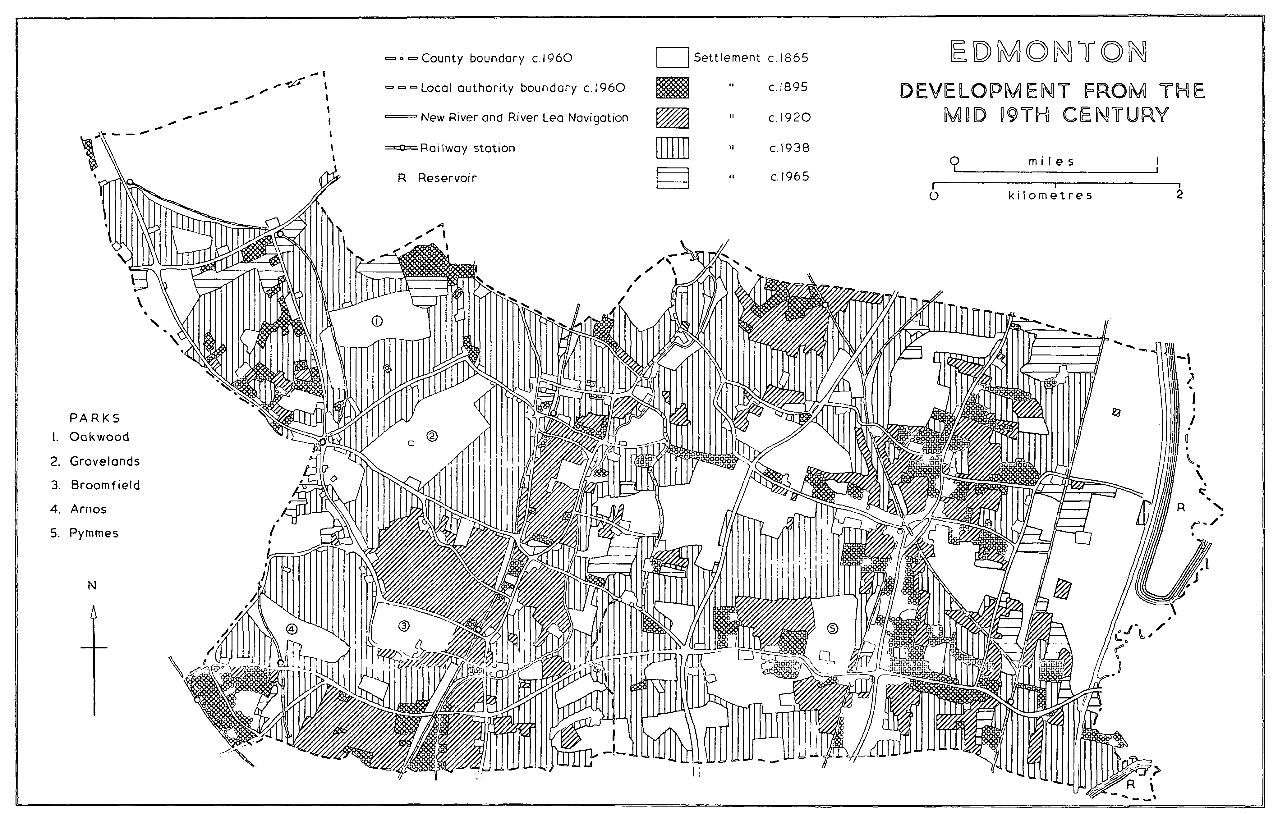
Inclosure of the common fields in 1804 greatly altered the appearance of the countryside, particularly in the eastern half of the parish, but had little effect upon the pattern of settlement, except in the Chase portion of Southgate. The spread of housing in the late 19th century was caused chiefly by the railway. After a station was opened at Colney Hatch in 1850 to serve the county lunatic asylum, in Friern Barnet, a settlement grew up at New Southgate in the 1850s and 1860s. (fn. 1) Building took place at Edmonton Green after the opening of a station there in 1849 (fn. 2) but not in Angel Road, where a station had existed from 1840. In 1872, however, when the line through Silver Street and Lower Edmonton was opened, the G.E.R., in accordance with the Great Eastern Railway (Metropolitan Station and Railways) Act (fn. 3) of 1864, introduced cheap workmen's tickets and when Liverpool Street station was built in 1874, the displaced population moved out to places like Edmonton. Consequently the areas bordering the railway grew rapidly. (fn. 4) Between 1861 and 1871 the number of houses in Edmonton rose from 2,079 to 2,539; in the next decade it increased to 3,887. The introduction of trams along Fore Street and Hertford Road in 1881-2 was an additional stimulus and the number of new houses doubled each decade, reaching 6,232 in 1891 and 10,613 in 1901. (fn. 5)
Most of the new housing was in the former Fore Street and Church Street wards. Around Lower Edmonton houses were being built in Hertford Road in 1878, (fn. 6) westward along Bury Street in 1881 and 1886, (fn. 7) and on the Millbrook estate to the south-west in 1882. (fn. 8) Chiswick and Kingston roads near by, the property of the British Land Co., were being built up in 1898. (fn. 9) On the eastern side of Hertford Road houses were spreading towards the marshes along Town Road in the late 1870s (fn. 10) and St. Mary's Road in 1882. (fn. 11) The United Counties Land Building and Investment Society was laying out the Orchard estate between New Road and the railway in 1899. (fn. 12) There was further extension west and north from Church Street, where Hyde House estate was built up in the 1880s. (fn. 13) By 1897 new streets branched off the main ancient roads, Hertford Road, Church Street, the eastern end of Bury Street, Town Road, and Bounces Road.
It was in Fore Street ward, round Upper Edmonton, that growth was most striking during the later 19th century. The area south of Silver Street had already been built up by 1851 and there were few changes except where the Bell inn was rebuilt in 1878 and Gilpin Grove was built on its gardens. (fn. 14) North of Silver Street and westward and eastward along Silver Street and Angel Road large-scale building, mostly of terraced houses, took place in the 1880s and 1890s. In 1889 Fore Street ward was divided into three, Fore Street itself with 715 houses, Silver Street with 702, and Angel Road with 880. (fn. 15) By 1893 there were 876, 984, and 999 houses respectively. (fn. 16) The growth in Angel Road, hitherto uninhabited because of its liability to flooding, became possible after the road was made up and the stream confined by concrete in 1883. (fn. 17) Workers moved there because Angel Road station provided convenient transport and the gasworks and Whitley's offered local employment. New roads began to appear on both sides of Silver Street; Ashwell Grove off Bull Lane existed by 1889 (fn. 18) but the two union workhouses to the south and the purchase by the council in 1899 of Pymmes Park to the north prevented further building. At the western end of Silver Street 57 a. of the Huxley estate were sold in 1887. Nineteen acres were sold between 1888 and 1894, and another 23 a. in 1898- 1900 to Frederick G. Lacey, a local builder, on condition that no building selling intoxicating liquors was erected there. (fn. 19) North of Angel Road houses spread from Fore Street eastward towards the railway line and along Fore Street itself there was infilling and rebuilding. (fn. 20) The Golden Fleece, for example, was rebuilt in 1892 and a parade of shops near by was erected in 1898. (fn. 21) The centre of civic activity then shifted from Church Street to Fore Street, where several public buildings were erected, the town hall in 1884, the public library in 1897, and the public baths in 1899. (fn. 22)
Social decline continued, as the surviving large 18th-century houses lost their spacious gardens and were surrounded by building. Edmonton was considered a suburban village as early as 1876 (fn. 23) and in 1884 its transformation, with that of Tottenham, was thus described by the general manager of the G.E.R., who well appreciated the effect of the workmen's tickets: 'each good house was one after another pulled down and the district given up entirely . . . to the working man'. (fn. 24) Speculators quickly erected small houses, close together and with shoddy materials. In 1880 some 'jerry builders' were prosecuted by the council and forced to pull down their constructions. (fn. 25)
At Bowes, Palmers Green, and Winchmore Hill the advent of the railway in 1871 did not immediately lead to building, mainly because big landowners resisted the sort of change which they had seen farther east. Building, therefore, usually followed the sale of an estate after a death. The church of St. Michael-at-Bowes (1874) and a few large houses, including Avondale College, had been built in Palmerston Road by the 1880s. In 1889 and 1890 Bowes Manor was put up for sale and by 1897 there was building on either side of the railway line, although Bowes Manor and its grounds were still untouched. (fn. 26) In 1879 the Eaton Park estate at Palmers Green, which included Eaton Villa and Highfield, a large red-brick house built after 1865, was offered in plots. Apart from a few houses, however, including one erected in Stonard Road in 1881, (fn. 27) building had not taken place by 1897. Hazelwood House and the Skinners' alms-houses (1895) were the only other buildings erected at Palmers Green before 1897. (fn. 28) Although Winchmore Hill long retained its wooded 'idyllic' character, (fn. 29) it contained 400-500 houses by 1882. (fn. 30) There was some building near the station and along Hoppers Road, Compton Road, Middle Lane (Station Road) and Wade's Hill. Large new houses included Stone Hall in Church Hill, built c. 1872, (fn. 31) and Broadfields in Wade's Hill. There were also several nurseries, mostly east of Winchmore Hill. (fn. 32) Apart from the portion next to Hertford Road, and a few houses built near the Stag and Hounds in 1899, (fn. 33) Bury Street remained unchanged throughout the later 19th century. At Bush Hill the two most important estates passed to builders, Bush Hill Park to the Bush Hill Park Co. in 1872 and Bush Hill after the death of Horace Harry, the owner, between 1890 and 1908. (fn. 34)
The rural character of Old Southgate, far from the railway and dominated by a few landowners, persisted throughout the later 19th century. It was the contrast with the rapidly changing eastern part of the parish that led to the separation of Southgate from Edmonton in 1881. Social changes nonetheless took place. Large crowds attended the cricket matches of the Walker brothers (fn. 35) and by 1876 it was said that Southgate had once 'boasted its patrician residents, but its aristocracy now consists of opulent citizens, with an occasional nabob'. (fn. 36) Brewers were particularly associated with Southgate and Winchmore Hill, where the Walkers, Taylors, Paulins, Booths, and Sir Edward Mann lived during the 19th century. (fn. 37) Minchenden was demolished in 1853 and Beaver Hall c. 1870 (fn. 38) and Mayfield and Laverock Cottage were built, probably between 1851 and 1865. (fn. 39) Apart from the erection of the village hall in 1882, however, there was virtually no change in Southgate High Street.
Meanwhile the countryside around Old Southgate gave way to suburbs, although inns and tea-rooms continued until 1914 to cater for walkers and cyclists from London. (fn. 40) To the north c. 1853 the Lambeth and Provincial Street Borough, a development society, planned a 241-acre estate stretching from Chase Side to Chase Road and Bramley Road. The plan included shops, 3 taverns, and 347 plots. The first house was erected in Avenue Road but the area was still too remote and building slowed down (fn. 41) until the construction of a reservoir allowed water mains to be laid and stimulated progress from the 1870s. (fn. 42) Cottages were built in Bramley Road in the 1860s, (fn. 43) and in Chase, Farm, Ivy, Chelmsford, and Nursery roads during the 1870s and 1880s. (fn. 44) Farther east Eversley Park in Green Dragon Lane was erected in 1865 (fn. 45) and a hospital was built on a 36-acre site next to World's End Road in 1886. (fn. 46) To the south growth continued during the 1880s and 1890s at New Southgate until by 1897 almost all available land in the triangle formed by Bowes Road, Palmers Road, and the Wood Green border was built up. (fn. 47) In 1905 New Southgate ward (175 a.) contained 698 houses; (fn. 48) most were for the middleclass, although a resident in 1912 complained of the smell from the near-by gas-works and the poverty of children in High Road. (fn. 49)
The district along the railway through Bowes Park, Palmers Green, eastern Southgate, and Winchmore Hill, became a middle-class suburb between 1900 and 1918. Housing was in demand by those able to afford the higher fares on the G.N.R. and on the trams, which were introduced along Green Lanes in 1907, (fn. 50) and at the same time land became available as estate owners died. In 1900 a Mr. Hill proposed to build 2,000 houses and shops on 120 a. at Bowes Park. (fn. 51) By 1905 Bowes Park ward, which included the area next to the railway, contained 1,578 completed houses on 240 a. (fn. 52) In 1900 there were plans for 400-500 houses on the 60-acre Hazelwood Park estate between Green Lanes and Hazelwood Lane and for 30 on the Highfield estate. (fn. 53)
EDMONTON DEVELOPMENT FROM THE MID 19TH CENTURY
The largest estate to be broken up was Grovelands (600 a.). It was offered for sale in lots in 1902 by the executors of Major R. K. Taylor, whose father (d. 1885) had resisted the introduction of the railway and refused to sell land for building. (fn. 54) Grovelands itself, consisting of 314 a. between the Bourne, Winchmore Hill Road, Church Hill, and the railway, and the Lodge estate, 27 a. between Green Lanes and Hazelwood Lane, were withdrawn unsold. Home farm, 62 a. north of Winchmore Hill Road, was sold as farm-land and the Waterfall estate (24 a.) lay outside Southgate but the rest of the land was acquired by builders. Old Park estate (130 a.), bounded by Alderman's Hill, Fox Lane, and the railway, was bought by the British Land Co., 2½ a. fronting Hoppers Road were bought by the Town and Country Land Co., and 9 a. fronting Green Lanes were sold for shops. (fn. 55) The unsold land was again on the market in 1909. (fn. 56) In 1910 Southgate U.D.C. bought 63 a. of Grovelands for a park and the rest was laid out for middle-class housing which, however, had not appeared by 1920. (fn. 57) The Lodge estate was being laid out in 1911, (fn. 58) although this, too, had apparently not been built up by 1920. (fn. 59)
Palmers Green ward contained 765 completed houses by 1905. (fn. 60) In contrast to Edmonton with its terraces of stock brick, heavy bay windows, and slate roofs, Palmers Green became a middle-class Edwardian suburb of lighter, red-brick houses with gables and timbering, derived from Norman Shaw and C. F. A. Voysey, (fn. 61) and parades of shops along Green Lanes in the 'Metropolitan Electric' style of c. 1880. (fn. 62) The Old Park estate had been built up by 1908 when the adjoining Clappers Green farm, 46 a. between Fox Lane and Bourne Hill, was sold for building. (fn. 63) Broomfield Park estate, 200-300 a. south-west of Palmers Green, became available in 1901. Southgate U.D.C. bought the house with 54 a. in 1903 and the rest, to the south and east, was covered by housing. (fn. 64)
Building spread northward from Palmers Green to Winchmore Hill, where 70 shops and 200-300 houses were planned in 1900 (fn. 65) and where there were 1,052 completed houses by 1906. (fn. 66) Their styles, with half-timbering, gables, towers, and finials, were intended to avoid the monotony of other neighbourhoods and to preserve a rural air, (fn. 67) although contemporaries considered that the charm of the district was being destroyed. (fn. 68)
At Bush Hill Park building continued and spread southward toward Bury Street. Some large detached houses, similar to those of Hampstead Garden Suburb, were built during the late 19th and early 20th centuries along Chase Side. (fn. 69) Southgate U.D.C. erected 82 houses before 1914, in Chase and Chelmsford roads in the former Chase area and in Tottenhall Road. (fn. 70)
Edmonton's working-class character became increasingly apparent c. 1900. After battles with the 'jerry builders' the U.D.C. decided in 1899 to provide council housing but negotiations to buy Brookfield estate were unsuccessful and no houses were built until after the First World War. (fn. 71) The introduction of the electric tram (1905) and the motor-bus (1913) to Fore Street attracted still more people. More large houses were demolished (fn. 72) and building spread eastward from Fore Street and Hertford Road, the Fairfield estate being built during that period. (fn. 73) Industry, attracted by the large population, grew steadily in Angel Road and spread northward along the canal. (fn. 74)
The remaining landed estates were sold for building in the period between the World Wars, when all parts of the area became accessible after the construction of Great Cambridge Road (1923-4), the North Circular Road (1931), and the Piccadilly line (1932-3). Huxley estate, which originally stretched from Silver Street to Palmers Green, had been reduced from 221 a. in 1888 to 179 a. in 1920. Hill House at Palmers Green was sold in 1922 (fn. 75) and a large area south of Hedge Lane, near the North Circular and Great Cambridge roads, was bought by Frank J. Lawes, a builder from Crouch Hill, in 1929. (fn. 76) The rest of the Huxley estate, including the farm and fields north of Hedge Lane and east of Great Cambridge Road, was sold in lots in 1930-32 (fn. 77) and built up shortly afterwards.
Much new housing was on land made available by the Church Commissioners, who granted building leases on 30 a. at Bowes Park in 1913. By 1923 there were 72 houses east of Green Lanes and south of Tottenhall Road and another 100 were planned. Nine acres east of Wolves Lane were leased in 1928 and 19 a. of the Tottenham rectory estate east of Tottenhall Road in 1933, with an agreement to build 30 houses a year until there should be 270. (fn. 78) In 1920 the Church Commissioners sold their largest estate, 170 a. of the former Hyde field south of Church Street, between Firs Lane and Victoria Road, to Edmonton U.D.C. (fn. 79) and by 1926 it was laid out as a garden suburb. (fn. 80) The Commissioners also sold 10 a. west of Green Lanes at Palmers Green to the Church Army Housing Co. in 1926 and 34 a. on the Enfield border, west of Hertford Road, to Edmonton Estates in 1932-4. (fn. 81)
Growth continued unevenly. Fords Grove estate, 75 a. east of Green Lanes, was offered for sale in 1920 for 'moderate sized residencies and cottages', which were said to be in great demand. (fn. 82) It sold but Oak Lodge estate, 239 a. east of Chase Road, failed to find a buyer because of its remoteness. (fn. 83) The Southgate House estate, 64 a. between Southgate High Street and the Bourne, became available after the death of the last Walker brother in 1922. The house and grounds were bought by the council for a school and the rest of the land by Edmondson's, a Muswell Hill firm which had already built up much of Winchmore Hill. (fn. 84) Houses in Southgate U.D. increased from 1,694 in 1881 to 5,051 in 1905 and 14,750 in 1931, (fn. 85) but building was mostly on the borders of the district, at New Southgate, Bowes Park, Palmers Green, and Winchmore Hill. The opening of the Piccadilly line transformed Southgate itself, where by 1934 750 houses round the station were planned for completion. Although growth was slower near the more northerly stations of Oakwood and Cockfosters, by 1937 continuous building stretched southward from the railway line to New Southgate. (fn. 86) Meanwhile in Edmonton U.D. a new industrial area arose at Bridport Road south of Silver Street and housing spread to the farm-land, nurseries, and brick-fields of the north and northeast. (fn. 87)
As farm- and park-land disappeared, speculators turned to the large houses. In Edmonton Bury Hall was demolished in 1920, Bury House c. 1933, Bury Lodge in 1936, and Weir Hall in 1934. (fn. 88) Mayfield in Southgate High Street was demolished, (fn. 89) Roseneath (11 a.) and Broadfields (14 a.) in Winchmore Hill were sold in 1931, (fn. 90) and Beaulieu (1¼ a.) in Firs Lane was sold in 1936. (fn. 91) Southgate U.D.C., faced with the spread of housing, bought part of each large estate that was offered for sale to provide public parks. In 1927 it purchased Oakwood Park (50 a.) from Sugden's executors (fn. 92) and in 1928 Arnos Park (44 a.) from Lord Inverforth. (fn. 93) In 1937, following the sale in 1933 of 100 a. of Chase land near the new railway (fn. 94) and in 1935 of Westpole farm (75 a.), (fn. 95) the council made an agreement with Sir Philip Sassoon to preserve the area south of the Enfield border as an open space. (fn. 96)
Most housing estates were private, the work of firms like Comfy Housing Estates which in 1936 erected houses in Cavendish Road to M. M. Lyons's design. (fn. 97) The first council estate in Edmonton was also the largest: under the Act of 1919 1,760 houses were planned on the Hyde estate, where contractors had built 232 by 1925 when the council changed to direct labour. By 1940 1,124 houses had been built on the Hyde estate, 208 on the Brookfield and 147 on the Montagu estates, both lying east of Fore Street and south of the railway line, 164 on Woolmer estate south of Angel Road, 153 on Galliard estate in the north between the railway and Galliard Road, and 114 at Wilbury Way south of Silver Street and east of Great Cambridge Road. There were also 86 on either side of Great Cambridge Road and 25 on the Houndsfield estate west of Hertford Road. (fn. 98) Meanwhile Southgate council had built 639 houses, mostly on two estates: in the Chase between Trent Gardens, Green Road, and Reservoir Road, and east of Green Lanes near Highfield Road, where land had been purchased before the war but where houses, of concrete made from clinker, were built only in the early 1920s. (fn. 99)
During the Second World War 433 houses were totally destroyed and 971 badly damaged in Edmonton borough alone. (fn. 100) The demand for housing was greater than ever in 1945 when, except in the north-east, there was little land left. Most of Nightingale farm had been laid out for housing in 1938 and the farm-house was replaced by factories after the war. (fn. 101) In 1949 Edmonton B.C. decided to locate industry at Claverings farm, where factories were built in the 1950s and early 1960s, and in the north it acquired Cuckoo Hall farm, where houses were built during the 1950s. (fn. 102) In Southgate building was resumed on the Chase and still proceeded in the early 1970s. (fn. 103) Most post-war construction has been either small-scale, on a nursery or large garden, or has taken the form of rebuilding. Examples of the former are the council housing in the old grounds of Halliwick at Bush Hill, the houses at Hydefield Close and Myrtle Road on former nurseries, the building in Blagden Lane, where the Wilderness had been, and Skinners Court, the flats at Palmers Green which replaced the Skinners' alms-houses. Edmonton B.C. rehoused substantially, replacing 19th-century terraces by tower-block flats, particularly in the 'jerry-built' areas of the 1870s and 1880s.
Between 1945 and 1963 Edmonton completed 3,911 houses and flats, of which 1,248 were at Potters Bar and Cheshunt (Herts.). (fn. 104) In the 1950s council housing, mostly blocks of flats, (fn. 105) was erected on Cuckoo Hall farm, on nursery ground east of Fox Lane, and on older sites south of Lower Edmonton and east of Fore Street, between Fore Street and the Enfield Town railway, at Snells Park, Jeremy's Green, and Barrowfield Close. The Galliard Road estate was continued and there were smaller sites in Church Street, Great Cambridge Road, and off Little Bury Street. In 1953 18 a. were acquired at Montagu South for industry. Since 1960 council housing has been built in the grounds of Halliwick, Barbot Street at Victoria Road, St. Mary's Road, Goodwin Road north of Bounces Road, Brettenham Road East, Angel Road North and South, College Gardens and Snells Park west of Upper Fore Street, Bolton Road at Silver Street, two sites in Church Street, and Walmer House in Bury Street.
In 1965 Enfield L.B. approved a comprehensive rebuilding scheme for 61 a. at Edmonton Green. The first stage was completed in 1970 when a shopping precinct, swimming pool, entertainment centre, and blocks containing 376 flats were opened on the east side of the old green. The second stage, comprising shops north of the new area, was nearing completion in 1974. (fn. 106)
Southgate erected about 500 houses and flats between 1945 and 1963. Shortly after the war about 250, mostly semi-detached, houses were built south of Barrowell Green and a few more at Barber Close, east of Wade's Hill. Later council housing consisted chiefly of three-storyed blocks in numerous small areas, usually surrounded by private dwellings. In the 1950s most building was in the Chase although there was also a little north of the North Circular and at New Southgate. Work continued during the 1960s and early 1970s on several relatively small sites, mainly in the Chase but also in Old Southgate, Winchmore Hill, and Tottenhall Road. The most important municipal project was the redevelopment of almost the whole of New Southgate, begun in the 1950s and still in progress in 1974. (fn. 107) Private firms then were replacing some large houses, as in Alderman's Hill and parts of Victorian Bowes Park, by blocks of flats.
After the building of Great Cambridge Road in 1923-4 Fore Street ceased to be the main north-south route through Edmonton but in 1974 it was still the main shopping centre and focus of social life. Examples of many styles, from classical 18thcentury houses to extravagantly Gothic late-19thcentury public buildings and chequer-board tower blocks of the 1960s, lined the street, usually behind shop fronts of the 1930s. On the east side of Fore Street no. 238 is an early-18th-century threestoreyed building with Doric pilasters, entablature, and architrave, and nos. 258 and 260 are threestoreyed houses with Ionic pilasters and entablatures dating from the 18th century. (fn. 108) Angel Place, four pairs of adjoining brown brick houses with open pedimented Roman Doric doorways, is also 18thcentury but in bad repair. (fn. 109) There are a few midVictorian houses north of the junction with Angel Road and one house of c. 1830 almost opposite St. James's church, which, with its mid-Victorian vicarage, stands surrounded by buildings of the 1960s and 1970s. To the north Fore Street enters the area where Edmonton Green was being transformed in 1974. The concrete masses of the new shopping precinct then looked across roadworks on the green to buildings awaiting demolition on the west, relieved only by the high tower and striking architecture of the National Coal Board heating station erected c. 1971 next to Salmon's brook. The air of decay peristed in Hertford Road, leading northward from the green, where villas and terraces of the late 19th and early 20th centuries were interspersed with modern flats and garages. In 1974 its one striking group of buildings, badly preserved, was the Crescent, segmental and of three storeys and basement, built of brown brick and stucco with Corinthian pilasters and a central pediment. (fn. 110)
The main east-west route through Edmonton remains Angel Road and Silver Street, transformed into the North Circular Road. Heavy traffic travels eastward along the wide Angel Road towards the factories and canals, and much of it turns north along Montagu Road with its industrial estates. To the east lies the railway and beyond it are the sewage works, allotments, waste-land, and reservoirs that mark the former Edmonton marsh, in 1974 being transformed into the Lee Valley regional park. Almost all the rest of the area between the railway and Fore Street and much to the west of Fore Street consists of small shopping parades and varied working-class housing, from the terraced and semi-detached houses of the 1920s and 1930s in the north to the mixture of mid-20th-century blocks of flats and 19th-century terraces in the south, the latter often brightly painted by the West Indian immigrants who form much of the population.
West of Fore Street the three ancient roads, Silver, Church, and Bury streets, have retained their identity amidst the building. Silver Street, predominantly 19th century, contains Pymmes Park, although not the house, and Millfield House, in 1974 awaiting conversion into an arts centre. (fn. 111) The latter, a late-18th-century mansion of brown brick, has a slate roof, Doric columns, and frieze. Inside it has an oval hall and original doorways and chimney pieces. (fn. 112) In Church Street styles are mixed. On the south side near Fore Street the girls' charity school of 1784 adjoins the former schoolmistress's house, an 18th-century red-brick cottage with a pantile roof. To the west on the opposite side of the road is Lamb's Cottage, a two-storeyed building of c. 1700 with a mansard roof and 18th- and 19th-century door and fittings. (fn. 113) The medieval church stands away from the road in its churchyard, surrounded on three sides by mostly modern houses. Apart from the alms-houses (1903) and the Lamb institute (1907) (fn. 114) Church Street consists mainly of Victorian detached and semi-detached houses, although there are council houses at the western end. Only one of the early houses of Bury Street survives. At the western end of the street amidst houses of the 1920s and 1930s stands Salisbury House, the oldest secular building in Edmonton, a gabled structure of c. 1600 with a brick ground floor and timberframed upper storeys. There are modern additions on the western side. The interior contains 17thcentury doors, panelling, and other fittings. (fn. 115)
Bush Hill, to the north-west beyond Great Cambridge Road, is a district of terraced and semidetached houses of the late 19th and early 20th centuries, relieved only by a wooded golf course on the Enfield border. Of the two large houses near by only Halliwick, formerly Bush Hill House, survives. (fn. 116)
Winchmore Hill in parts retains the air of a large village or superior suburb. The King's Head, rebuilt in 1896 (fn. 117) and with an art nouveau interior, faces the green, where five roads meet. The northern side of the green is lined mostly with antique shops in a parade dated 1895. Despite much rebuilding Rowantree House and Woodside House on the south-west, of painted brick with slate roofs, attic windows, and eaves cornices, survive from the mid 18th century with 19th-century extensions. (fn. 118) Church Hill, which runs north-east from the green, contains the late-18th-century Quaker meetinghouse, the early Victorian Gothic St. Paul's church, the 18th-century Devon House, of brown brick with dormers, (fn. 119) and a few 19th-century weatherboarded cottages and large semi-detached houses, besides later dwellings. Some early-19th-century weatherboarded and brick cottages and Glenwood House, of the same date, are in Wade's Hill, which also runs north from the green. Early-19th-century houses with Doric porches stand in Vicars Moor Lane, (fn. 120) leading east from Wade's Hill.
Green Lanes and most of Palmers Green are characterized by late-19th- and early-20th-century shops and housing, stretching eastward from Winchmore Hill along Station and Compton roads. Other old buildings survive south of Winchmore Hill. Eaton Villa, a square detached house at the Palmers Green end of Bourne Hill, is mid-19thcentury and Truro House, named after the Lord Chancellor Thomas Wilde, created Lord Truro of Bowes in 1850, is a buff-coloured brick house of the 1820s (fn. 121) with a timber-framed addition of 1917 and a late-18th-century doorcase with Corinthian capitals. Edwardian Palmers Green is surrounded by housing estates of the 1920s and early 1930s.
Green Lanes leads south to Bowes Park, where a Greek Cypriot community gives variety to the otherwise uniform terraced houses and shops of c. 1900. A few earlier large Victorian houses survive in Palmerston Road. Both Bowes Park and its westerly neighbour, New Southgate, once full of 19th-century villas but later a working-class semiindustrial district, have much decayed housing which in 1974 was being replaced by flats.
Southgate, on higher ground farther north, is separated from New Southgate and Bowes Park by the wooded Arnos and Broomfield parks. Although predominantly a middle-class suburb of the 1930s, its centre is the much older green and High Street, formerly South Street. The street leads to Southgate Circus, created in 1933 around Southgate station which is on or near the site of the south gate of the Chase. In High Street older buildings are interspersed among houses and flats built before and after the Second World War. Croft Cottage, Holcombe House, and Avington (nos. 111-5) were built in the late 18th century as a unit, with a central three-storeyed house flanked by two-storeyed houses, each with reeded flat-topped doorcases. (fn. 122) Numbers 107-109 date from the early 19th century. On the eastern side amid playing fields is Minchenden school, which incorporates Southgate House, the home of John Lawrence (d. 1879), 1st Lord Lawrence of the Punjab, a late18th-century yellow-brick building, much altered. Minchenden Lodge in Blagden's Lane is a large square mid-19th-century house with a later conservatory and there are terraced 19th-century brick and weatherboarded cottages on the east side of High Street. Ash Lodge (no. 40), a small early19th-century grey-brick house with a roundheaded arched doorway, and Norbury and Sandford Houses (nos. 38-9), a late-18th-century brownbrick pair with pedimented door and 19th-century bay windows, form a group on the east where High Street runs into the green. A little to the south the Cherry Tree inn, 17th-century but much altered, is set in a terrace designed by Michael Searles (d. 1813). (fn. 123) On the north side of the green next to some modern flats are Old House (no. 2), late-18thcentury, and Arnoside and Essex House, an early18th-century brown-brick pair with a parapet, wrought iron gates, and stone urns. On the south of the green there are large detached houses and flats of the 1930s and to the west the road leads to Christ Church and the cricket fields. Cannon Hill, which runs south to Broomfield Park, is lined mainly by detached houses of c. 1910 and c. 1930 but also contains Northmet House, formerly Arnos Grove, Cannon House, an early-19th-century brick villa, and the Hermitage, a mid-19th-century cottage orné.
Several roads radiate from Southgate Circus. The Bourne, running south-eastward to Palmers Green, has a mixture of houses built between 1910 and 1939 and forms the southern boundary of Grovelands Park, wooded grounds which contain a lake and surround the house, later a hospital, designed by John Nash. Running north-eastward from South gate Circus is Winchmore Hill Road, where among mostly modern houses, flats, and shops are Rose Cottage and Linden Lodge (nos. 229-31), 19thcentury brick cottages near the junction with Church Hill. Chase Road and Chase Side, leading north and north-westward respectively, are characteristic of the southern part of the Chase, with houses of many dates and styles from the mid 19th century. Farm-land survives north of Bramley Road, forming part of the Trent Park estate in Enfield rather than the built-up district of Southgate.
The population of Edmonton rose from 9,708 in 1851 to 10,930 in 1861 but the steepest rise, reflecting the introduction of workmen's tickets on the railway, was from 13,860 in 1871 to 23,463 in 1881. The population thereafter increased at an ever faster rate, to 61,892 in 1901, 98,409 in 1911, and 133,215 in 1931. It reached 177,647 in 1951 and then declined to 164,315 in 1961. (fn. 124)