A History of the County of Middlesex: Volume 12, Chelsea. Originally published by Victoria County History, London, 2004.
This free content was digitised by double rekeying. All rights reserved.
'Settlement and building: From 1680 to 1865, south-east Chelsea and the Royal Hospital', in A History of the County of Middlesex: Volume 12, Chelsea, (London, 2004) pp. 41-47. British History Online https://www.british-history.ac.uk/vch/middx/vol12/pp41-47 [accessed 25 April 2024]
In this section
SOUTH-EAST CHELSEA AND THE ROYAL HOSPITAL
The area from Flood Street eastwards to the parish boundary and south of King Road was mainly open fields in 1680, apart from King James's College and the premises to the west of the college between the road from Westminster and the Thames. In 1682, however, the college was sold to the Crown with adjoining land as the site for the Royal Hospital, which triggered the growth of new building in the area.
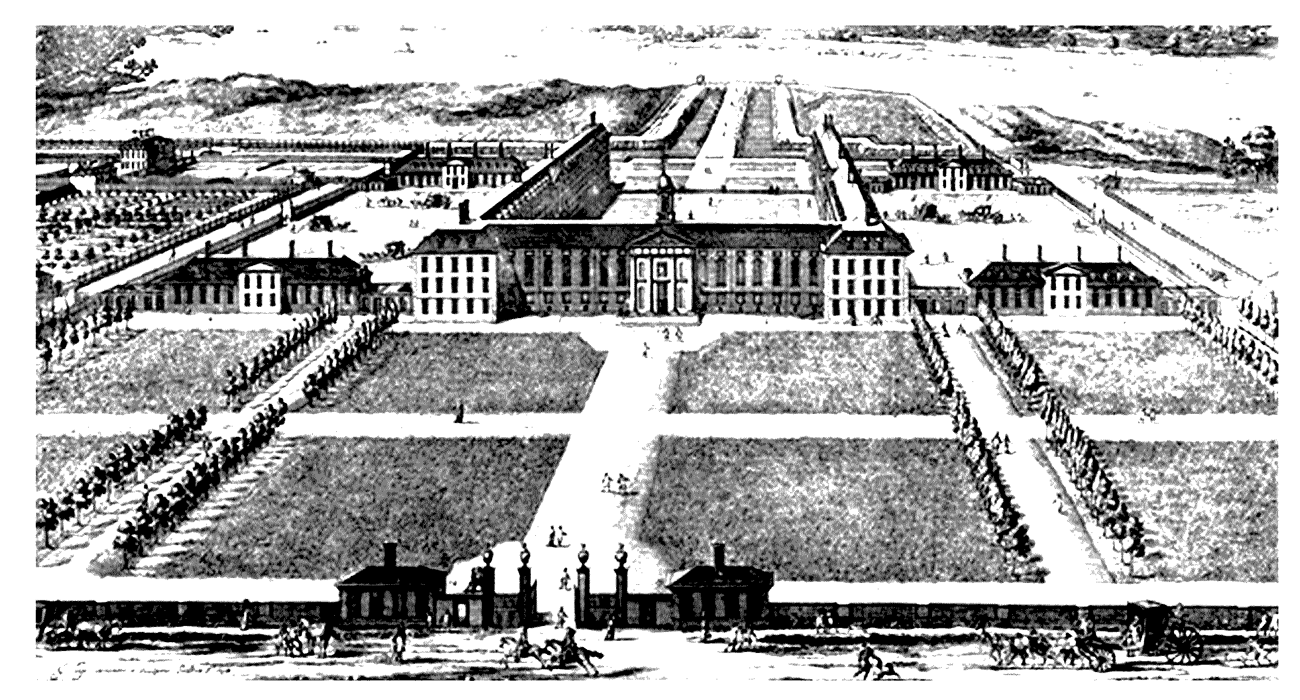
The Royal Hospital from the north 1694, with Ranelagh House in distance (top left)
THE ROYAL HOSPITAL
The building of the Royal Hospital, which continued occasionally to be called Chelsea College, had a striking effect on Chelsea's development. It was the first major new royal building since the Restoration, and gave Chelsea a cachet to counter the aristocracy's dwindling interest in residences in the riverside village. Royal patronage and architectural grandeur almost immediately attracted speculators and ambitious individuals to build houses in its immediate vicinity, the superior houses in the reticent brick Dutch-influenced style used by Wren for the Hospital.
Charles II founded the hospital in 1681 for maimed and aged soldiers following its promotion by Sir Stephen Fox, Paymaster-General of the Army: it was hoped that the Hospital could be funded by charitable contributions, but despite assistance by the king out of the Privy Purse only a few thousand pounds were raised, and Fox had to assist by the creation of a fund from deductions from army pay. The foundation stone was laid in February 1682 and work continued until the central lantern was completed in 1689: 476 non-commissioned officers and men were admitted from that year, and the Hospital was completed in 1691 with the consecration of the chapel and burial ground. Sir Christopher Wren, one of those involved in its foundation, chose the site and, using the Doric order, designed an establishment on appropriately austere masculine lines. (fn. 1) Wren's planning, with one quadrangle facing south to the Thames, continued the fashion, begun in the late 16th century, for Chelsea's prestigious buildings to acknowledge the river, and gardens with avenues and an access canal, designed by London and Wise, extended from the building to the riverside. (fn. 2) On the north side the large open rectangle of land called Burton's Court, created by 1688, (fn. 3) preserved an open aspect to the Hospital; the carriage drive from the central gate across Burton's Court to the north side was linked to King's Road by the Royal Avenue by 1700. (fn. 4) On the east side of the Hospital, south of the burial ground which bordered the south side of the highway, was the walled physic garden with fruit trees and herbs, a small two-storeyed Apothecary's Laboratory, and a 2-acre kitchen garden. (fn. 5)
The building history of the Hospital is well known, (fn. 6) and several craftsmen connected with building in Chelsea were involved, including Thomas Hill, mason, and Henry Margetts, plasterer. (fn. 7)
BUILDING WEST OF THE HOSPITAL
The steady development after the Restoration of mainly industrial premises by the Thames close to Chelsea village continued in the 1680s. In 1686 Lord Newhaven leased to William Kemp junior of Chelsea, brewer, land east of the Physic Garden and stretching between the road and the Thames, with a covenant to spend £600 on building within 10 years. Kemp was prosecuted by the City of London, as Conservators of the Thames, for inclosing 15 feet of the river foreshore into his premises, and by 1689 had built a brewhouse, contrary to his agreement with Cheyne which forbade buildings for brewing, sugar-making, or other offensive trades. (fn. 8) By 1695 there were not only several houses built in this area between the Physic Garden and the College, but also a dye house and wharf by the Thames, and a passage ran back to give tenants access to a stairs or causeway to the river. (fn. 9)
With the building of the Hospital, residential building began away from the mainly industrial developments by the Thames, and became concentrated by the end of the 1680s in the highway leading past the Hospital, called Jew's Row or Royal Hospital Row on the east side of Burton's Court, and Paradise Row on the west side; the highway in front of the hospital was diverted to go around the north side of Burton's Court in 1688, taking about an acre of ground, and remained thus until 1846 when it was relaid straight across the front of the Hospital and renamed Royal Hospital Road. (fn. 10) The reasons why the Hospital generated growth in building are complex. Building work at the hospital probably created demand for accommodation, and some builders may also have seen the prospects for growth in the area. By the early 18th century accommodation was also needed near the Hospital for the out-pensioners who had to attend the Hospital regularly. However, the presence of the Hospital also seems to have attracted notable and aristocratic residents, particularly in Paradise Row: the imposing setting of the Hospital and its royal connections may be partly the reason, as well as the fact that two substantial suburban mansions were created when land east and west of the Hospital was leased by the Crown to favoured officials. On the west side of the Hospital's outbuildings, a lease of 4½ acres of Great Sweed Court was granted by the Crown in 1690, and in the late 1690s rooms in the south-west corner of the stables, which adjoined the leasehold land, became a residence used in association with the leasehold, which was laid out as a garden; the entrance to the house, however, was from the Hospital's stableyard. The house was occupied first by its creator, Edward Russell, earl of Orford, and then by Sir Robert Walpole, PaymasterGeneral, from 1714. (fn. 11) Walpole employed Sir John Vanbrugh to enlarge the house, and design stables and coachhouse and garden buildings including the surviving orangery. Another wing was added to the main house in the early 1720s. After Walpole's death in 1745 the house was the residence of a number of noblemen, before being sold to George Aufrere, a London merchant and art connoisseur, but in 1808 the lease was surrendered back to the Crown and reoccupied by the Hospital.
The buildings of the Hospital, and consequently its surroundings, were much changed after the American War of Independence, when the infirmary premises had proved inadequate. From 1778 temporary premises had been taken on, (fn. 12) until in 1809 John Soane, Clerk of the Works to the Hospital from 1807, built a new infirmary on the site of Walpole House, incorporating part of the house; it was destroyed in 1941. The stables and offices were also rebuilt to Soane's design between 1814 and 1824. Soane's more extensive buildings presented a new, stately, neoclassical and stock brick face to adjacent roads. South of the stables the former orangery of c. 1725 of Walpole House was used for the pensioners' library and RC chapel in 1991. (fn. 13) The southernmost portion of the garden of Walpole House was leased in 1810 for 80 years to Sir Willoughby Gordon, Bt, who built Gordon House there. After the lease expired the building was used for the infirmary nursing staff. (fn. 14)
North Side of Paradise Row
Even before building began on the Crown leaseholds, speculative building was beginning along the highway to the Hospital, particularly on the Chelsea side. In 1691 Lord Cheyne granted several building leases for land on the north side of the highway: Paradise Row, a terrace of ten houses which later gave its name to the stretch of highway there, was built by George Norris in 1691 on the north side near the eastern end and opposite the Hospital stables. The houses, demolished in 1906, were all of two storeys with attic rooms lit from dormers, but some had five bays each and others three. All lay behind walled and railed forecourts. (fn. 15) The large corner site at the eastern end of the Row, 287 feet by 210, was leased to Thomas Hill of Chelsea, principal mason of the Hospital, who built Ormonde House on the site. It received its name when it was occupied by the Duchess of Ormonde, 1720-33; other occupants included Sir Thomas (later Lord) Pelham 1700-3, and the countess of Bristol, 1704-8. It was later used by a naval academy 1777-1829 and then Mrs Elizabeth Fry's School of Discipline. (fn. 16) At his death in 1713 Thomas Hill held building leases in St James Westminster and in London, as well as three leases in Chelsea, on one of which he had built c. 1693 the house in Paradise Row where he was living at his death. This had two rooms on the ground floor plus kitchen, closet, and cellars, three rooms on the first floor and three garrets over, with a brewhouse in the yard, and his possessions at his death included 55 maps and prints, as well as his masonry stock of marble, Portland stone, and several chimney pieces. He was owed money for work by Sir William Milman, Francis Cook, Henry, earl of Rochester, the Royal Hospital, Dr Hans Sloane, the countess dowager of Lindsey, Narcissus Luttrell, Jonathan, bishop of Winchester, Oliver Maddox, and Richard, late earl of Ranelagh; he was also owed £1668 by William III for work done, presumably on the Hospital, a debt classed as desperate. (fn. 17) At the western end of Paradise Row, at the corner of Robinson's Lane, stood Radnor House, which obtained its name from Laetitia Isabella, countess of Radnor, who was living there by c. 1704 and continued there until 1714: (fn. 18) the house existed for some years before 1704, and may have been built in the late 1670s. (fn. 19)

Paradise Row, Royal Hospital Road, built in the 1690s and photographed shortly before demolition in 1906
Between Radnor House and Paradise Row were several other houses and garden ground by c. 1704. (fn. 20) By 1745 the north side of Paradise Row is shown as solid rows of houses which turned the corner northwards up Robinson's Lane. (fn. 21) Between 1794 and 1813 one or more houses was demolished to give access to George Place, a row of 11 small cottages. (fn. 22)
South Side of Paradise Row
On the south side of Paradise Row, a mansion later known as Gough House was built by John Vaughan, 3rd earl of Carbery, by c. 1704, (fn. 23) on the site of Little Sweed Court west of Lord Orford's Crown leasehold, with a garden laid out in terraces down to the Thames. Carbery lived there until his death in 1713, when the property was sold to the Gough family. Sir Richard Gough also held Lord Orford's leasehold 1714-19, building stables at the northern end by the highway, but in 1719 Sir Robert Walpole took over most of that land, leaving only the stables and Lord Orford's gazebo by the river with Gough House. (fn. 24) By 1792 the owner, Sir Henry Gough-Calthorpe, let the western half of his estate from the highway to the river west of the house and garden to James Beattie, jeweller, for building: five houses fronting Paradise Row had been built by 1792, and behind them 17 small cottages either side of the narrow Calthorpe Place, running towards the river, had been built by 1794. (fn. 25) Between 1814 and 1836 Paradise Wharf was built at the southern end of Calthorpe Place. (fn. 26) Gough House remained more or less unaltered until it was converted into the Victoria Hospital for Children in 1866. As part of the embankment scheme, Tite Street was laid out along the south-west wall of the house and garden, obliterating the east side of Calthorpe Place. (fn. 27)
Further west along the south side of Paradise Row at least four houses (later nos 71-4 Royal Hospital Road) were built in the early 18th century west of Bull Walk, (fn. 28) as were possibly the two or three houses in Swan Walk which stood by 1745 and survived in 2003. Philip Miller, curator of the Physic Garden, lived in a house in Swan Walk 1733-40, and at no. 1 Swan Walk 1741-62. No. 3 Swan Walk was built in 1776; the rest of the land formed gardens to the houses. The Old Swan Inn on the riverside at the southern end of Swan Walk became famous as the finish of the annual watermen's race instituted by Thomas Doggett in 1715, but it was converted into a brewery later in the 18th century and another inn called Old Swan was opened on the west side of the Physic Garden. (fn. 29) In 1745 the area still mainly consisted of houses along the highway and wharves and buildings by the river at the end of Swan Walk and Bull Walk, with only a little building in between. (fn. 30) By 1794 Paradise Row from Gough House to Cheyne Walk was lined with houses, except at the Physic Garden. In addition to the cottages and gardens in Calthorpe Place, Bull Walk, renamed Paradise Walk about this time, had two rows of houses at the north and south ends with a few individual buildings including an Independent chapel opened c. 1793. Swan Walk had a large timber yard behind its houses, but both here and in the other alleys was still much open ground. West of the Physic Garden, however, the area was filled with houses and commercial buildings. (fn. 31) The east side of Paradise Walk was nearly filled with cottages by 1813, (fn. 32) and though by 1836 a few more had been added on the west side, most of the remaining open ground was used in connection with the wharves and commercial buildings by 1865. (fn. 33)
BUILDING EAST OF THE HOSPITAL
On the east side of the hospital all the land on the south side of the highway as far as the parish boundary belonged to the Crown in 1690. The Hospital burial ground was created along most of the south side in 1691, with gardens for the Hospital behind. In 1688 Richard Jones, earl of Ranelagh, Paymaster-General of the Army and treasurer of the Hospital, began building an official residence for himself near the south-east corner of the Hospital, laying out gardens on the 7½-acre site of which he was granted a Crown lease in 1690; another 15 acres were added in 1693, also laid out with walks and orchards. (fn. 34) Access to the house was via Wilderness Row, a lane running south from the highway near the Westbourne, which had a row of cottages by c. 1700, (fn. 35) but by 1745 an avenue later called Ranelagh Walk or Grove had been created to run to the house across the Westbourne from Ebury (Westm.). (fn. 36) The house and gardens were greatly admired by topographers and visitors: (fn. 37) Defoe lavished praise c. 1724 on Ranelagh House, its situation, gardens, and pictures. (fn. 38)
In the early 1730s the estate was sold off in lots, and the main portion including the house and c. 12 acres were sold partly as building land but were mainly used to create the Ranelagh pleasure gardens; an enormous timber rotunda was built in 1741 linked to Ranelagh House, and the gardens opened in 1742 to become one of the most fashionable pleasure resorts of the 18th century, attracting royalty and nobility as well as a host of lesser visitors, with access by river as well as by road. (fn. 39) In the 1760s Sir Thomas Robinson, one of the proprietors of the pleasure gardens, built a mansion east of the rotunda to his own designs called Prospect Place, where he lived until his death in 1777; by the 1790s the house had been divided. In 1803 the pleasure gardens closed and Ranelagh House, the Rotunda and other features were cleared. This part of the estate then became gardens in the ownership of the Hospital. Another of the proprietors, Edward Wilford, held land east of Prospect Place, which his son General Richard Wilford acquired and demolished, building a new mansion nearby where he lived until 1822, (fn. 40) which seems to be that called Ranelagh House in 1836. (fn. 41) In 1857-8 Chelsea Bridge Road was laid in a straight line from a widened White Lion Street to the new Chelsea Bridge, sweeping away the later Ranelagh House, Wilderness Row and the eastern end of the burial ground; all the land west of the road was thrown into the Hospital's gardens, including land lying in Westminster. (fn. 42) The land between the new road and the Westbourne was taken for Chelsea Infantry barracks 1860-2. (fn. 43)
On the north side of the highway there was little building c. 1700: at the extreme eastern end of the parish by the Westbourne was Fleet's garden including a house; a few houses stood at the corner of the highway by Burton's Court; and the half dozen houses of Franklin's Row faced the east side of Burton's Court. (fn. 44) The houses at the corner presumably included a tavern, later the site of the Royal Hospital public house, a picturesque plastered building coloured white with a large bay window on the first floor. (fn. 45) Franklin's Row, six houses facing the centre of the eastern side of Burton's Court north of the main highway was said to have been built in 1699 by a Chelsea farmer and contractor, Thomas Franklin, who also built the Angel and Soldier nearby, the first tavern in the neighbourhood. (fn. 46)
The well-to-do may have taken the houses in Paradise Row, and possibly in Franklin's Row, but they were not the only people wanting accommodation near the Hospital. Old soldiers seeking admission or claiming a pension had to apply in person to the Hospital, a regulation which was not relaxed until 1816 and only finally abolished in 1845. Even after being placed on the pension lists, they had to come up to Chelsea regularly for the half-yearly payments or could be summoned for medical examinations or posting. (fn. 47) The rapid increase in building in the first half of the 18th century, including several taverns, seems to be intended to meet the soldiers' requirements.
Gospelshot in Eastfield on the north side of the highway opposite the burial ground was let as garden ground by the 1680s, but in 1693 three parcels of this land were let for building by Charles Cheyne. (fn. 48) Sir Hans Sloane granted building leases for parcels here from at least 1716 to the late 1720s, to builders including Thomas Harding of St Clement Danes, Sampson Biddle of St Giles-in-the-Fields, Henry Tregeare of Chelsea, John Turner, and Robert Luing of London, who built brick houses and a few shops, mainly on 36-ft wide plots fronting the highway with long gardens behind. On the east side of the land a new 30-ft street called Princess Street ran northwards from the highway by 1726, later renamed White Lion Street. (fn. 49) By 1722 10 feet at the north end of each parcel was reserved to create a new 20-ft wide street, (fn. 50) by 1745 known as Turk's Row, running parallel to the highway, which was known as Jew's Row, (fn. 51) both presumably a popular reference to the fleecing of soldiers said to go on there. (fn. 52) By 1745 Morgan's Ground had been built on the remaining land on the east side of the White Lion Street.
In 1723 land on the north side of Turk's Row was let for building, to John Ward, carpenter, and Ralph Appleton, bricklayer, both of Westminster, (fn. 53) and on part of their land Garden Row was built in 1733 facing Burton's Court, (fn. 54) consisting in 1794 of seven houses with long gardens behind. (fn. 55) The rest of Gospelshot north and east of Garden Row up to King's Road was leased for 91 years from 1747, and was the site of a mansion, stable and gardens, held with a parcel of leasehold meadow containing 6½ acres. The house was built by 1745, (fn. 56) and by 1788 the leases belonged to Charles Lord Cadogan; the house was said to have been used by the Cadogan family in the 1770s. In 1788 the mansion was sold at auction and bought by Sir Walter Farquhar, Bt, to whom the owners of the manor granted new 99-year leases. (fn. 57)
Many old, poor soldiers obviously lived more or less permanently in the Jew's Row area, and their funerals had to be paid for by the parish. The Royal Hospital refused to pay parish rates for the gentlemen's houses on the Crown land, until a court case brought by the parish resulted in a fixed assessment of £100 being made in 1751. By 1781 this only covered about a fifth of the amount it cost the parish to maintain poor pensioners and their families. The demand for accommodation seems to have caused building to spread eastwards by 1745 across the Westbourne into Five Fields and Ebury (Westm.), where the famous Chelsea Bun House stood. Many of the buildings fronting the road were taverns and alehouses, and in 1734 the Board which managed the Hospital unsuccessfully requested the local JPs not to licence gin-shops nearby. (fn. 58) By 1794 at least four of the plots between Jew's and Turk's rows had alleys running along their length with rows of tiny cottages and other buildings, and half a dozen narrow courts giving access to more buildings including a second row of houses inserted behind part of the frontage to Jew's Row; (fn. 59) several more courts and yards had been added by 1836. In 1829 the block was condemned as the worse eyesore in the parish. (fn. 60) The remaining frontage to Franklin's Row had been filled with courts adjoining the public house on the corner by 1794, and on the east side of that block White Lion Street, called Little Sloane Street in 1794, was lined with cottages, as was George Street near the Westbourne, a short street with some cottages facing the Westbourne and open ground behind. On the south side of Jew's Row, now renamed Royal Hospital Row, several houses and other buildings stood at the eastern end of the Hospital's burial ground by Wilderness Row. (fn. 61)
WEST AND NORTH OF BURTON'S COURT
Land north and west of Burton's Court was largely unbuilt c. 1700: on the north side the Royal Avenue had been laid down and a house and garden called Robins Garden stood at the corner with the King's Road. (fn. 62) By the north-west corner of the Court stood two or three buildings called 'Mr Franklin's houses', (fn. 63) standing on part of the Greene estate of which Thomas Franklin was the tenant, (fn. 64) and facing the west side just north of the gardens of Paradise Row stood a tavern called the Ship with garden and orchard behind. (fn. 65) By 1745 a couple of houses and gardens stood each side of the junction of Blacklands Lane and King's Road, inclosed from the adjoining fields, and a couple more at the south-western end. More buildings had been added behind Mr Franklin's houses, and possibly an access lane running north to King's Road. On the west side of Burton's Court an alley between the gardens of Paradise Row and the Ship was lined with small buildings and led to a few more at the end of the Ship's grounds. (fn. 66) By 1769 buildings fronting King's Road and called the Royal Dairy had been built midway between Blacklands Lane and Royal Avenue. (fn. 67) They seem to be those later known as Whitelands, which housed a girls' school in 1772 and Whitelands House School in 1797; (fn. 68) by 1836 the buildings had been enlarged. (fn. 69) In 1842 the lease was purchased by the National Society for the Training of Schoolmistresses and it was thereafter known as Whitelands Training College. (fn. 70) Also by 1769 a large house had been built on the Greene estate fronting King's Road, and the five houses called Green's Row, which survived in 2003 as nos 26-30 St Leonard's Terrace, had been built on the north side of the highway facing Burton's Court and the Hospital: (fn. 71) they were said to have been built in 1765. (fn. 72) Another house had been built close to the west side of Mr Franklin's houses, while at the western side of this area in Robinson's Lane the line of houses at the southern end had been extended a little way northwards. (fn. 73)
By 1794 considerable building had taken place, especially on the former Greene estate, which had been divided and sold off by that date. (fn. 74) Thomas Smith acquired a large portion of the land north of Green's Row and laid out Smith Street across the site of Mr Franklin's houses of c. 1700, extending the road on the west side of Burton's Court northwards to join King's Road. Building leases for land on both sides of Great Smith Street from King's Road to the south side of Little Smith Street were granted from 1794 to 1801 and in 1812. (fn. 75) Land in Smith Street leased by Thomas Smith for building in 1801 included six unfinished houses on the west side, a vacant plot 260 ft by 80 ft, and another 1½ a. (fn. 76) In 1812 Smith leased to Jacob Franks land at the south-east corner of Smith Street, bordered on the east by Green's Row, on which Franks was building a house. (fn. 77) Terraced rows of houses on either side of Smith Street had been started at the northern end and near the southern end on the west side, while on the east Little Smith Street ran eastwards with small cottages on the south side and the two buildings of Morley's floorcloth factory on the north lying behind the Smith Street houses. A detached house fronting King's Road lay on the remaining land east of the factory. (fn. 78) By 1813 Smith Street had been completed, and on the land between Smith's development and the Royal Avenue another builder had begun the houses at the southern end of Hemus Terrace facing Royal Avenue and a group of five houses facing Burton's Court near the junction with Royal Avenue, (fn. 79) called Rayner Place in 1836. (fn. 80) By 1859 in addition to houses Smith's former ground included a slaughterhouse, the Phoenix public house, and a stable. (fn. 81) On the west side of Burton's Court a large mansion in its own grounds was built in 1780 by Thomas Richardson facing east down the road on the north side of Burton's Court, and called Manor House by 1836. (fn. 82) Next to that on the south side was a terraced row of seven houses called Durham Place facing Burton's Court; the tavern called the Ship had been renamed Durham House by 1813. South of that the grounds north and east of Ormonde House had been filled by another terraced row of 15 fairly small houses, with another two facing Paradise Row. (fn. 83)
Along King's Road the detached house standing west of Smith Street in 1794 had apparently disappeared by 1813, when another house called Manor House stood further west in King's Road facing Jubilee Place, with another detached house on the west side, and a terraced row of 7 houses called Sidney Place fronted King's Road next to the junction with Robinson's Lane. At the southern end of Robinson's Lane a row of seven more terraced houses had been added by 1794 north of the existing row, and a large building, possibly a farm, had been built to the north of the houses, the gap being filled with more small houses by 1813. (fn. 84)
Sir Walter Farquhar's house and land between Turk's Row and King's Road were acquired for the Royal Military Asylum for the Children of Soldiers of the Regular Army, (fn. 85) founded by Frederick Augustus, duke of York, and a building with two long side wings designed by John Sanders was built 1801-2 across the site from north to south, with the entrance in Franklin's Row, at a reported cost of £40,000. (fn. 86) The brick building had a stone balustrade in centre of the western front ornamented with a Doric portico of 4 columns, pediment and frieze, and the north and south wings were joined to the main building by a colonnade: the latter contained the dining halls with school rooms over, and apartments for officers and for boys and girls in the wings. The Asylum was opened by 1805. The girls were moved to Southampton in 1823, and in 1829 the Asylum had 1,000 boys. (fn. 87) Blacklands or Whitelands Lane ran along the western boundary of the school site, and a strip of glebe belonging to the rector of Chelsea, which lay on the west side of the lane, was bought on behalf of the Crown, confirmed by Act in 1815. In 1816 the lane (later renamed Cheltenham Terrace) was moved to the west of this addition in order to enlarge the school's grounds. (fn. 88) A triangular piece of land on the east side of the school was nursery ground in 1836, but was occupied by the Asylum in 1865. (fn. 89)
In the mid 1840s St Jude's church and a National school were built on the north side of Turk's Row. (fn. 90) By 1847 building along King's Road virtually filled the whole frontage between Robinson's Lane, now called Queen Street, and Royal Avenue, though much land behind the main streets remained open as market or nursery gardens, or the grounds to larger houses. (fn. 91) In King's Road between Sidney Place and Manor House more rows of houses fronted the road with Shawfield Street running southwards and partially built up. Queen (later Flood) Street also had rows of houses at its northern end, leaving only a small portion of unbuilt land in the middle of the east side. Manor House in King's Road had extensive grounds laid out behind it, and to the east houses lined King's Road to Smith Street with Little's Botanic Nursery behind. The floorcloth factory behind Smith Street had been demolished and the area awaited redevelopment. The terrace on the west side of Royal Avenue was nearly complete, but land on the east side was still unbuilt. Facing Burton's Court, Green's Row had been extended to join Rayner Place. (fn. 92) In 1845 the approach from King's Road to the Royal Hospital had been improved by removing old chestnut trees and laying out a garden instead, giving an unrestricted view of the Hospital. A terraced row of houses was being built on the east side on the site of a former nursery garden. (fn. 93) At the same time Radnor Street was being laid out and building leases granted. (fn. 94) In 1847 George Place, north of Paradise Row, was swept away to give access to Christ Church built on former garden ground. (fn. 95)
By 1865 the garden ground occupied by Henry Little in 1847 was a nursery, as was the ground occupied by William Puvey. The grounds of Manor House, Smith Street, stretching west to Queen Street were still unbuilt, but elsewhere the whole area was covered in building or about to be so. The former garden ground around Christ Church was built up with small terraced houses in Elizabeth and Caversham streets and Christchurch Terrace. The Manor House in King's Road had either been demolished or radically altered to allow Radnor Street to run south from the main road filled with terraced houses either side; from the southern end a passage led into Smith Terrace built eastwards to Smith Street over former garden ground. The three sides of Wellington Square had been built on the site of the floorcloth factory between Smith Street and Royal Avenue, open to King's Road. Both sides of Royal Avenue were filled with substantial terraced houses, Walpole Street with similar houses had been built to the east, and St Leonard's Terrace to the south fronting Burton's Court. The grounds south of Whitelands School had also been built over.