A History of the County of Oxford: Volume 12, Wootton Hundred (South) Including Woodstock. Originally published by Victoria County History, London, 1990.
This free content was digitised by double rekeying. All rights reserved.
A P Baggs. W J Blair. Eleanor Chance. Christina Colvin. Janet Cooper. C J Day. Nesta Selwyn. S C Townley, 'Hanborough: Introduction', in A History of the County of Oxford: Volume 12, Wootton Hundred (South) Including Woodstock, (London, 1990) pp. 158-164. British History Online https://www.british-history.ac.uk/vch/oxon/vol12/pp158-164 [accessed 20 May 2024].
A P Baggs. W J Blair. Eleanor Chance. Christina Colvin. Janet Cooper. C J Day. Nesta Selwyn. S C Townley. "Hanborough: Introduction", in A History of the County of Oxford: Volume 12, Wootton Hundred (South) Including Woodstock, (London, 1990) 158-164. British History Online, accessed May 20, 2024, https://www.british-history.ac.uk/vch/oxon/vol12/pp158-164.
Baggs, A P. Blair, W J. Chance, Eleanor. Colvin, Christina. Cooper, Janet. Day, C J. Selwyn, Nesta. Townley, S C. "Hanborough: Introduction", A History of the County of Oxford: Volume 12, Wootton Hundred (South) Including Woodstock, (London, 1990). 158-164. British History Online. Web. 20 May 2024, https://www.british-history.ac.uk/vch/oxon/vol12/pp158-164.
Introduction
Hanborough lies c. 6 miles (9 km.) north-west of Oxford, and about mid way between the market towns of Woodstock and Witney. (fn. 52) It contains two villages: Long Hanborough, which has developed into a dormitory village for Oxford, and the smaller Church Hanborough. The parish, roughly triangular in shape, is bounded by the river Evenlode on the north and east, except for a short section on the north where the river seems to have been diverted by the construction of Combe mill. A small tributary of the Evenlode, called Caverswell brook in the Middle Ages and Eynsham brook in the 16th and 17th centuries, forms the short southern and part of the western boundary. Those boundaries have apparently been unaltered since medieval times, but the remainder of the western boundary, which follows field boundaries from the point at which it leaves the brook, south-west of Church Hanborough village, was changed in 1932 and again in 1948, reducing the area of the parish from 2,270 a. to 2,125 a. (860 ha.). (fn. 53)
The ancient boundary, first shown on a map of 1761, seems to have matched those of Eynsham, described in 1005, and of the eastern portion of Wychwood forest, within which Hanborough lay, described in 1300. (fn. 54) The forest boundary ran up the Caverswell brook to Cavershull meadow, later Chasehill close, then between Mousley wood and le Frith to Walter the vintner's house in Hanborough. Walter held 1/2 yardland in socage in 1279, perhaps on the site of Little Blenheim on the edge of the modern Freeland village where there seem to have been five cottages in 1609-10. (fn. 55) From Walter's house the boundary ran to Robert le Eyr's grange, leaving the grange itself in Eynsham, and to Blowens on the site of the modern Cook's Corner. The next boundary mark, Roweleye, cannot be positively identified but was presumably on Hanborough heath, as the element 'row' usually means 'rough'. (fn. 56) From there the boundary ran to Leyhambrok, presumably the small stream which runs along the western edge of Hanborough heath, and to Colnham, the small tributary of the Evenlode which forms the parish boundary for a short distance north of Abel wood and whose name was preserved in Colnham meadow in Combe. (fn. 57) The building of houses or walled closes across the boundary west of Church Hanborough had led to slight alterations to the perambulation route, if not the boundary, by 1628. (fn. 58) In 1932 Hanborough parish was extended westwards by the addition of 977 a. around the hamlet of Freeland, formerly in Eynsham parish, but the change was reversed in 1948 when Freeland civil parish was created. (fn. 59)
Much of the ancient parish, including both villages, lies on the Thames gravel, the northern part on the Hanborough terrace, the southern part on the Summertown-Radley terrace and the flood plain. In the centre of the parish and along its western boundary the soil is clay; much of that area was wooded in the Middle Ages, and one wood, Pinsley wood, survived in 1986. Along the Evenlode are wide bands of alluvium, limestone of the great oolite series, forest marble, and cornbrash. The alluvium has supplied Hanborough with extensive meadow, and the limestone and forest marble have been quarried intermittently since the Middle Ages. Hanborough heath in the north-west corner of the parish lies on unbedded glacial drift. (fn. 60) The ground rises from the Evenlode valley in the north and east and the smaller valley of the brook in the south and south-west to a T-shaped hill or ridge on which both Long Hanborough and Church Hanborough stand and from which the parish takes its name: Hagena's, Hanna's, or possibly cock's, hill. (fn. 61) The slope is fairly gentle on the south and east, but much steeper in the north and parts of the west. The highest land is near the north-west corner of the parish, 100 m. above sea level at Cook's Corner and on the Church Hanborough road in Long Hanborough, and the lowest, 65 m., in the Evenlode valley on the eastern boundary. (fn. 62)
The parish was within Wychwood forest in the Middle Ages, and a number of Hanborough men were accused of forest offences in the 13th century. Among them was the rector's son, Hubert, who in 1254 was accused of poaching in Woodstock Park and of regularly receiving stolen deer to take to Oxford, presumably for sale. (fn. 63) Hunting rights continued to cause friction in the 19th century when a tenant of the duke of Marlborough complained that the duke's rabbits and pheasants from Pinsley wood ate a large proportion of his crops. (fn. 64)
The Witney-Bicester road, an ancient route which was called port street in the neighbouring Eynsham parish in 1005, runs across the parish from east to west near the northern boundary, and is the focus for the village of Long Hanborough; (fn. 65) it was turnpiked in 1751 and disturnpiked in 1870. (fn. 66) The road branching from it just west of Hanborough bridge and running south was the main route from Eynsham to Woodstock, called the Woodstock way, by 1605, but has never had more than local importance. It has been suggested that the road through Millwood End, which continues by a bridle path to North Leigh, and the road from Long Hanborough to Church Hanborough, which continued to Eynsham until inclosure in 1773 when it became a footpath, were part of a prehistoric route from the North Oxfordshire iron fields to Uffington on the Berkshire ridgeway, (fn. 67) but the evidence is not conclusive. A network of minor roads and paths joined the different parts of Hanborough to each other and to Freeland, North Leigh, and Combe. The surviving road to Freeland was Heathfield Lane in 1605, preserving the name of a boundary mark recorded in 1005, and Heath Lane in 1761; the modern name, Pigeon House Lane, was applied in 1761 only to the eastern end of the road which runs past Hanborough rectory house and its outbuildings. A more northerly road to Freeland was called Powes Lane in 1605 and Fowles Lane in 1761; it seems to have disappeared at inclosure.
Hanborough bridge, over the Evenlode on the Witney-Bicester road, existed by 1141 when the Empress Maud granted Oseney abbey land at Hanborough by the Bladon (or Evenlode) bridge. (fn. 68) Traces of stone piers remain just north of the surviving late 18th-century bridge, and the churchwardens made payments for four days' work 'at the old bridge' in 1783-4. (fn. 69) In 1798 the bridge was completely rebuilt with two flattened stone arches over the main stream of the river and two small flood arches to the west, the cost apparently being shared between the turnpike trust, Hanborough parish, and the duke of Marlborough. (fn. 70) Further repairs in 1828, 1840, and 1867 were carried out by the county. (fn. 71) Between 1952 and 1954 a new bridge was built a few yards north of the 18th-century one, removing a dangerous corner on the road. (fn. 72)
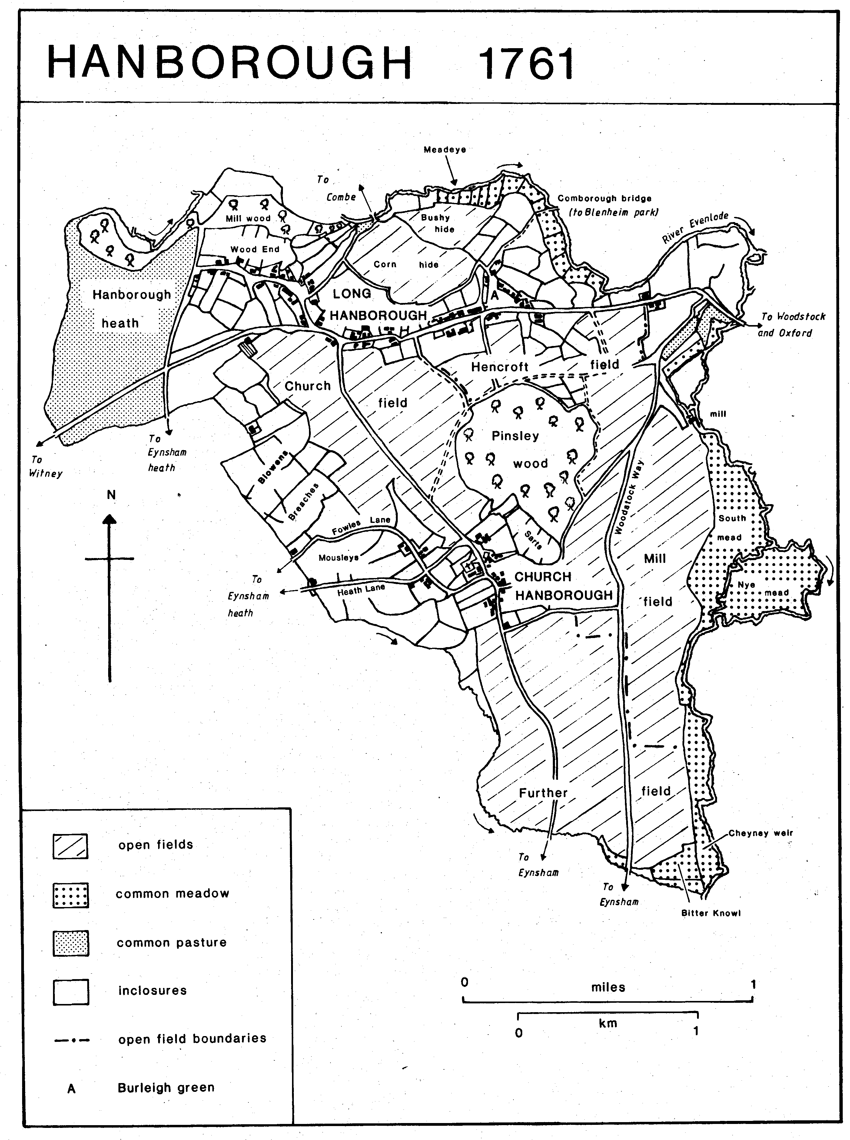
Hanborough 1761
Both roads south to Eynsham crossed the boundary brook by fords in 1605, and the lower ford, presumably on the Woodstock way, was recorded in 1663, (fn. 73) but there was a footbridge across the brook in 1610, perhaps the Tolcon or Token bridge recorded in Eynsham deeds. (fn. 74) The Church Hanborough path crossed the brook by a plank in 1773, when there may still have been a ford for carts on the Woodstock way. (fn. 75) In the 18th century a track running north-east from Burleigh green to Blenheim Park crossed the Evenlode at Comborough bridge, which survived as a footbridge in 1883 but apparently disappeared soon after; stone foundations along the bank remained visible in 1988. (fn. 76)
A station was opened at Long Hanborough in 1853 on the Oxford, Worcester, and Wolverhampton Railway. For a few years from 1854 the station was the junction for a service to Euston using the L.N.W.R. line from Yarnton, and was enlarged to accommodate the extra traffic. Local protests helped save the station from closure in 1964, and it remained open in 1986, although most of the station buildings were demolished in 1966-7. (fn. 77)
Witney and Woodstock seem to have been the usual market towns for Hanborough people in the 16th and 17th centuries. (fn. 78) In the 19th century carriers' carts ran to Witney once a week and to Oxford twice a week. (fn. 79) A bus service to Oxford and Witney was introduced in 1922 and became a daily service in 1955. (fn. 80) There seems to have been no post office in the parish until 1877. (fn. 81)
Wells supplied almost all the water in Hanborough until 1935 when mains water from Witney was connected. (fn. 82) Main drainage was completed in 1963, and a sewage disposal works, at Downhill farm just west of Church Hanborough, was opened in 1964. (fn. 83) Electricity reached the parish c. 1932. (fn. 84)
A palaeolithic hand-axe found in Long Hanborough is important for the dating of the Hanborough gravel terrace, (fn. 85) but the first evidence of settlement in the parish dates from the Bronze Age when a barrow cemetery and a henge monument were constructed on the Summertown-Radley gravel terrace at the southern tip of the parish. Flints of the same date have been found at Long Hanborough, where the Hanborough gravel terrace also attracted early settlement. Two Iron Age farmsteads, one occupied in the 2nd or 3rd century B.C. and the other about the 1st century A.D., were established near the Eynsham boundary. The inhabitants of the earlier settlement may have been iron workers; pits for smelting iron ore, roughly contemporary with the settlement, were found nearby. Further north, near Cook's Corner, which stands on a small patch of gravel terrace, were two early Iron Age and two early Roman pottery kilns. The evidence suggests scattered and intermittent settlement throughout the prehistoric period. (fn. 86)
No early Anglo-Saxon house sites have been found, but in the pagan period the area of the Bronze Age cemetery at the southern tip of the parish was again used for burials. (fn. 87) Early settlement was presumably also on the gravel, perhaps on the sites of Church and Long Hanborough. A swain's croft was recorded in 1005 on the Eynsham boundary, probably at Cook's Corner, and later evidence confirms scattered settlement over much of the north and west of the parish by the 13th century. Church Hanborough, clearly in existence by the 12th century when the existing church was built, was probably the manorial settlement; traces of the fishpond which Henry I or Henry II made on Eynsham abbey's land survive in a field southwest of the village. (fn. 88)
A total of 26 unfree tenants and 5 servi was recorded on Hanborough manor in 1086. (fn. 89) By 1279 numbers had risen to 91 customary and free tenants (excluding the abbot of Oseney), 34 of whom held only assart land. (fn. 90) Surnames indicate that several of them lived in Long Hanborough, and others occupied farmsteads along the western boundary of the parish. Agnes at Wood probably lived in the later Wood End or Millwood End of Long Hanborough, and John, Walter, and another John at Hacche were probably near the 'hatch' or gate at the junction of the Church Hanborough road and the WitneyBicester road. Robert at Bridge was perhaps near Hanborough bridge or possibly Combe bridge, where traces of what may be house platforms survive, and William at Wytheg (willow) is also likely to have lived near the Evenlode. Linnot of Heathfield presumably lived on Heathfield Lane near the later Little Blenheim. All were customary tenants holding land in the common fields, and most of their holdings are likely to have been established by 1086. The same is probably true of the land held by tenants in socage, two of whom bore the surname Blowend, related to the field names Blowens or Blowings located by later maps on the high, and thus perhaps exposed and cheerless, (fn. 91) ground near Cook's Corner. Further south, the submanor of Downhall had been established by 1279 on land west of Church Hanborough village. One tenant of assart land bore the surname at Ford, perhaps referring to a crossing of the Evenlode towards Combe or of the brook which formed the boundary with Eynsham. Great Bondon or Bandon, recorded in 1312, 1376, and 1410, (fn. 92) appears to have been another settlement in or near the parish, but it has not been identified.
Only 143 people over 14 were recorded in 1377, and the population does not seem to have increased greatly by 1609-10 when there were c. 87 tenants on the manor. (fn. 93) Despite a large excess of recorded baptisms over burials in most years from 1560 to 1640, (fn. 94) the population appears if anything to have declined, perhaps because of large-scale emigration or of consistent under-registration of burials. Fifty-nine people were assessed for hearth tax in 1662, and only 142 adults were reported in 1676. (fn. 95) The reduction in the population did not lead to much contraction of the area of settlement. In 1609-10 there were 4 cottages at or near Blowens, and 5 others which seem to have been on the Eynsham boundary near the modern Little Blenheim, as well as c. 52 houses or cottages in Long Hanborough and c. 16 in Church Hanborough. Long Hanborough was usually divided into two 'ends', Burleigh End, first recorded c. 1535, which centred on Burleigh green at the eastern end of the village, and Wood End, first recorded in 1610, the later Millwood End. (fn. 96) The modern names of the farms or hamlets Cook's Corner and Little Blenheim were not recorded until 1820 and 1851 respectively. (fn. 97) Cook's Corner presumably takes its name from an earlier owner or tenant, although in 1763 and 1841 it was occupied by members of the Woodward family. (fn. 98) The origin of the name Little Blenheim is obscure, but may be connected with the Blenheim estate, which acquired nearby land in Eynsham in 1789.
The population rose slightly in the later 17th century and the early 18th, with an increase in both baptisms and burials. The 1720s were years of high mortality, the number of burials reaching a peak of 27 in 1729, but there had probably been some recovery by 1738 when the curate reported a total of 130 houses in the parish, 110 in Long Hanborough and 20 in Church Hanborough. (fn. 99) The rising number of baptisms in the later 18th century suggests that the population continued to grow; in 1801 it was 655, but the number of houses had fallen to 100. (fn. 1) The population rose steadily to a peak of 1,153, including 60 probably itinerant railway labourers, in 1851, then fell fairly steadily to 816 in 1921. Long Hanborough remained by far the largest settlement; separate figures for the villages in 1891 gave the population as 805 in 179 houses in Long Hanborough, 160 in 36 houses in Church Hanborough, and 40 in 10 houses in Little Blenheim. (fn. 2) Since 1921 Long Hanborough has grown rapidly as a dormitory for Oxford; in the decade 1961-71 the population of the parish almost doubled, from 1,380 to 2,460. In 1981 it was 2,697. (fn. 3)
Church and Long Hanborough have developed very differently in the 20th century, Long Hanborough being designated as an area for expansion, Church Hanborough one for conservation. As a result, Church Hanborough is still a small, quiet, village, dominated by its church standing on the edge of what was once a small green but which has been converted into a car park. Most of the houses are mid to late 18th-century cottages or small farmhouses, reflecting the relative poverty of the village in the 17th and 18th centuries and the absence of any gentry families at that date. They are built of local stone, most with slate roofs, although two of a row of cottages on the eastern edge of the village are thatched, as is the house opposite the Freeland road. A house on that site was shown on a map of 1605, and it is possible that the surviving house contains 17th-century work. Just to the south is a small 18th-century farmhouse to which a symmetrical front, in coursed rubble with ashlar window surrounds, was added in the late 18th century or the early 19th. The chief 19th-century additions to the village were the school, north-west of the church, and the new rectory house to the north-east, both private houses in 1986. Two other houses bear 19th century dates, Priest's Close (1834) and Church Cottage (1893); Church Cottage was probably restored in 1893 as the house appears to be substantially older. There has been some infilling, with large, detached, houses, and a small estate has been built north of the church.
The oldest surviving house in Long Hanborough is the Malt House, in Millwood End, once the property of Edward Henmarshe, warden of Durham College, Oxford. It was said to have been built as a refuge for the Durham College monks in time of plague in Oxford, and was described as a fair house in 1553. The core of the surviving house, including the remains of a central smoke-bay, probably dates from that time. The house was altered in the later 16th century, probably by Leonard Perrott, tenant from c. 1550, (fn. 4) when a four-centred stone fireplace was put into a first floor room. It was greatly extended in the 17th and 18th centuries. Baker's Court, on the south side of the road, retains some 17th-century stonework, notably a staircase projection. The 17th-century staircase apparently survived until the conversion of the building into old people's flats in 1971. (fn. 5) Just south-east of Baker's Court is a terrace of 18th- century cottages, two of which bear dates, K:RM 1735, for Richard Keen and his wife Mary, and I:WA 1793, possibly for William Judd. Further north-west is Millwood Farm, a substantial mid 18th-century farmhouse, and another group of cottages, one of which is dated H:RP 21, possibly for Richard Harris, who acquired a cottage in Hanborough in 1720. (fn. 6)
A much-altered cottage at the north end of Park Lane, formerly Burleigh green, bears a datestone apparently of 1618. No. 76 Main Road dates from the 16th century or early 17th; it is a small house, of local limestone with a thatched roof supported by crucks. The original house, the farmhouse for ½ yardland, was of one storey with an attic and had on the ground floor only two rooms separated by the chimney stack, but the house was twice extended westwards during the 20th century and divided into two cottages; it again became a single dwelling in the 1960s. (fn. 7) A house on the site of the Manor House, on the south side of Main Road almost in the middle of the village, was occupied by the Butcher or Bouchier family from the later 16th century until c. 1763. The house had no connexion with any manor, and the name Manor House was not recorded until 1841. (fn. 8) The surviving house was built by Thomas Bouchier in 1628 as a long east-west range with a short cross wing at the east end. Later in the 17th century another Thomas Bouchier remodelled the house, building two detached blocks to the north of the long range to make a symmetrical forecourt; he also enlarged the garden, planting an avenue of trees along the street front. (fn. 9) In the 18th century a short wing was added south of the main range and rusticated gate piers were erected at the courtyard entrance on the main road. The detached later 17th-century block on the east was linked to the original cross wing in the 19th century, and c. 1980 the cross wing was extended southwards. The ground floor of the main range was gutted in the earlier 20th century. In the 1970s the stable block to the southeast was the Blenheim Motel, but by 1986 it had been converted into flats.
The chief 19th-century additions to the village were the new church, Christ Church, built on the north side of Main Road almost opposite the road to Church Hanborough in 1893, and Methodist chapels of 1827 and 1895 a little further east and on the south side of the road. Opposite the manor house is the small school, built in 1879 and still in use in 1986. At the east end of the village, the railway station was built in 1853. Among the cottages built in the 19th century were those in the Row, at the west end of the village, and a small terrace of later 19th century workers' cottages at the top of the road to Church Hanborough.
The Blenheim estate started to sell building plots in Long Hanborough in 1910, and since the 1920s large estates of council and privately-owned houses have been built there, principally in Millwood End and on either side of the Church Hanborough road. Council houses were built on the Church Hanborough road in the 1920s and 1930s, but in 1946 the parish council complained about the lack of housing in the parish. (fn. 10) More houses were built in the late 1940s and 1950s, mainly in the area between the main road and Pinsley wood. In 1963 the Wimpey construction company built an estate of over 100 houses at Millwood farm, and by 1965 the first stage of the Marlborough Fields estate had been completed. Further development was carried out at Millwood End in 1970 and 1973. (fn. 11) Most of the occupants of the new houses came from outside the parish. A survey in 1966 found that 30 per cent of households had settled in Hanborough within the previous four years. Only 16 per cent of those employed had jobs in the parish; nearly half the working population travelled to Oxford, most of them to Morris Motors or Pressed Steel, and the rest worked in Witney or neighbouring villages. (fn. 12) Since 1966 some light industry has been started in Long Hanborough, but most inhabitants still work in Oxford or elsewhere in the county.
There was an alehouse in Hanborough c. 1533, when a litigant claimed that a will had been forged there, and three victuallers were presented for breach of the assize of ale in 1634. (fn. 13) An alehouse called the Katharine Wheel was recorded in 1661, and in 1686 and 1693 the churchwardens spent money 'with the neighbours' at the Holly Bush, presumably another alehouse; at least seven alehouse licences were issued in 1701. (fn. 14) Between 3 and 6 houses were licensed each year between 1753 and 1774, 1 or 2 in Church Hanborough, the remainder in Long Hanborough. In 1775 the houses were named as the Hand and Shears, the George, the Bell, and the Ball. A fifth house, called the Swan from 1778, seems to have opened in 1777, but in 1778 the Ball apparently closed. (fn. 15) A house, later called Shepherd's Hall, associated with the brickworks on Hanborough heath, was a public house by 1851, and the Three Horseshoes, on the corner of the Church Hanborough road and Main Road in Long Hanborough, by 1861. (fn. 16) All six houses were still open in 1986, the Hand and Shears opposite the church in Church Hanborough, the George and Dragon, the Bell, and the Three Horseshoes in Main Road, Long Hanborough, and the Swan on the corner of Millwood End and the road to Combe.
Henry I stayed at Hanborough, presumably in the manor house, in 1105. (fn. 17) Charles I passed through the parish in June 1644 at the end of his night march from Oxford, and drew up his army on Hanborough heath before continuing to Burford, (fn. 18) but otherwise the Civil War does not seem to have affected Hanborough greatly.
In 1795 a cartload of flour and wheat bound from Witney to Chipping Norton was siezed outside the Bell by a crowd reportedly of several hundred, some from Witney and many of them women, who beat the driver and forced him to sell the contents at a low price. (fn. 19) A public meeting of agricultural labourers was held at Hanborough in 1872 during the dispute between farmers and labourers in Wootton and and other nearby villages, and shortly afterwards the union was said to be making rapid progress at Hanborough. In 1877 the union men supported one candidate for churchwarden, the farmers another; after an acrimonious campaign and poll, during which the rector was insulted several times, the farmers' candidate was elected by a narrow majority. The following year the rector reported that the labourers' union had stirred up much ill feeling towards the church. (fn. 20)
In 1741 the churchwardens presented a husbandman for failing to provide the usual food for those who beat the parish bounds, an omission which, they claimed, might endanger the custom. (fn. 21)