A History of the County of York: the City of York. Originally published by Victoria County History, London, 1961.
This free content was digitised by double rekeying. All rights reserved.
'The sites and remains of the religious houses', in A History of the County of York: the City of York, ed. P M Tillott (London, 1961), British History Online https://www.british-history.ac.uk/vch/yorks/city-of-york/pp357-365 [accessed 9 May 2025].
'The sites and remains of the religious houses', in A History of the County of York: the City of York. Edited by P M Tillott (London, 1961), British History Online, accessed May 9, 2025, https://www.british-history.ac.uk/vch/yorks/city-of-york/pp357-365.
"The sites and remains of the religious houses". A History of the County of York: the City of York. Ed. P M Tillott (London, 1961), British History Online. Web. 9 May 2025. https://www.british-history.ac.uk/vch/yorks/city-of-york/pp357-365.
In this section
THE SITES AND REMAINS OF THE RELIGIOUS HOUSES (fn. 1)
ST. MARY'S ABBEY occupied an extensive site immediately outside the city walls, lying between Bootham and the Ouse: the precinct walls enclosed about 12 acres of ground with a circumference of nearly three-quarters of a mile. (fn. 2) On the north-east the abbey wall followed the line of Bootham from Bootham Bar to St. Marygate (now Marygate), separated from the highway by a ditch and a narrow strip of ground; (fn. 3) near the bar, the wall was breached by a postern flanked by a small tower, and at Marygate stood the circular St. Mary's Tower; between them were two other small towers. (fn. 4) On the south-east, the abbey wall was separated from the city wall by the city ditch. (fn. 5) The intervening space was apparently not continuous, for in 1260 permission was given for a wall to be built 'up to the infirmary of the hospital of St. Leonard's', i.e. up to the city wall. (fn. 6)
On the south-west the precinct was bounded by the Ouse but the exact position of an abbey wall on this side is not known. Such a wall is said to have been built in 1334, (fn. 7) and in 1354 the abbey was given permission to complete the building of 'their wall on the said water [Ouse]'. (fn. 8) The precinct wall was set back from the river, running obliquely from Marygate to a point near St. Leonard's Tower, and it may have contained a small gateway. (fn. 9) There is no evidence that a staith existed within the precinct, and the abbey evidently used a landing at the end of Marygate, within the abbey's liberty. (fn. 10)
On the north-west the abbey wall followed the line of Marygate from a tower on the river bank to St. Mary's Tower at the junction with Bootham. The river tower and adjoining stretch of wall prevented access to the ground between the Ouse and the river wall. The main abbey gateway was situated in Marygate, adjoining the church of St. Olave which, together with 4 acres of land, had constituted the foundation gift of the abbey. (fn. 11) Two small towers stood between the river and the gateway, and a third between the church and St. Mary's Tower. (fn. 12)
Beyond Marygate lay Almery Garth which was perhaps the site of the abbey almonry. (fn. 13) It was said in 1756 to contain about 25 acres. (fn. 14) Another piece of abbey ground, a meadow called Little Ing, lay between Almery Garth and the Ouse. (fn. 15)
The foundation stone of the abbey church was laid in 1089; (fn. 16) this Norman church was rebuilt during the abbacy of Simon de Warwick (1258-96) who is said to have laid the first stone of the new choir in 1270. (fn. 17) Simon had completed the precinct wall in 1266. (fn. 18) The main abbey gateway may have been built even earlier than the wall, (fn. 19) but the postern near Bootham Bar was not constructed until 1497. (fn. 20) While the small wall towers were no doubt built with the wall itself, St. Mary's Tower may well have been a later construction: in 1354 it was referred to as the new round tower. (fn. 21)
The abbey church and extensive conventual buildings have been revealed by excavation. (fn. 22) The Norman church consisted of nave, transept, and a short presbytery with an apse, flanked by three pairs of chapels with apses. As rebuilt by Abbot Simon, the church was 350 ft. long, and consisted of a nave with aisles, north and south transepts with chapels in an eastern aisle, and a presbytery with aisles. The cloister lay on the south side of the nave. To the east of the cloister and on the line of the transepts were a vestibule leading to the chapter house, the scriptorium and library, and the monks' dorter. On the west side of the cloister stood the building of the lay brothers; on the south side were the warming house and monks' frater. Beyond these ranges were the kitchen, novices' building, infirmary, and a number of unidentified buildings. The hospitium stood 100 yards south of the west front of the church; the abbot's house lay north-east of the conventual buildings.
A court and prison for the liberty of St. Mary were both contained within the abbey gatehouse (fn. 23) which also housed a chapel dedicated to the Virgin. (fn. 24) There was apparently a substantial building adjoining the hospitium but its nature and purpose are not known. (fn. 25)
The abbey was surrendered in 1539 (fn. 26) and the site was retained by the Crown. (fn. 27) The abbot's house became the headquarters of the Council in the North and was known as the King's Manor; thereafter it has a separate history. (fn. 28) There were substantial remains of the abbey buildings, besides those of the King's Manor, in the time of James I: the church walls and steeple were standing, though the roof had been destroyed; the gatehouse was in a good state although the court house needed repair; and the frater, dorter, conventual kitchen, abbot's kitchen, privy dorter, infirmary, and other buildings all remained, although all were in need of extensive repairs. (fn. 29) In 1692 the abbey site was leased to Robert Waller for 31 years (fn. 30) and, later, to Sir William Robinson. (fn. 31)
During the 18th century much stone was removed from the abbey ruins for building elsewhere: in 1701 for the York County Gaol; (fn. 32) in 1705 for St. Olave's Church; between 1717 and 1720 for Beverley Minster; and about 1736 for the landing stage of Lendal Ferry. (fn. 33) Most of the site was occupied by pasture and gardens in 1736. (fn. 34)
In 1827 the newly founded Yorkshire Philosophical Society (fn. 35) received a grant of the abbey ruins and 3 acres of ground, and the site was carefully excavated (see plate facing p. 357). (fn. 36) In 1836 the society purchased a further 5 acres of the site, together with the abbey wall from the Ouse to the main gateway; it then owned most of the site of the abbey church, together with the gatehouse, hospitium, and river tower. (fn. 37) Restoration work was carried out on these buildings in subsequent years. (fn. 38) Another 3 acres of the abbey site were leased from the Crown in 1862 and in turn let to other tenants: part of this new acquisition was exchanged for the site of the choir of the abbey church which had been leased by the Crown to the Yorkshire School for the Blind as part of the King's Manor. (fn. 39) In 1877 the abbey wall from St. Olave's Church to the abbey postern was granted to the society. (fn. 40)
At various dates the society bought property adjoining the abbey wall and towers in order to expose and preserve them; (fn. 41) in 1896 the corporation assumed responsibility for the upkeep of the entire abbey wall, with the exception of the main gatehouse. (fn. 42) Further excavation of the church was carried out in 1900-2, (fn. 43) 1912-13, (fn. 44) 1944, (fn. 45) and 1952-4. (fn. 46) In 1912 a lecture theatre was added to the society's museum involving the roofing-in of the remains of the vestibule to the chapter house. (fn. 47) The church ruins and hospitium were in 1928 and 1929 inspected by the Office of Works who carried out renovation work in subsequent years. (fn. 48)
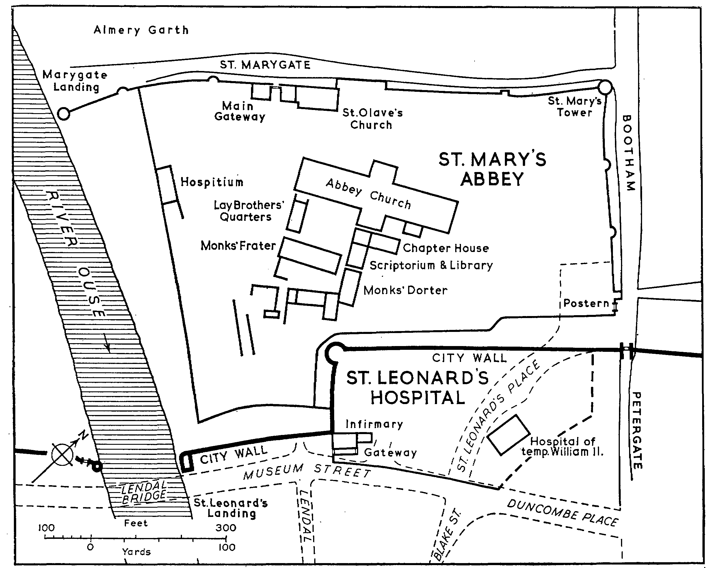
Diagram to show the sites of St. Mary's Abbey and St. Leonard's Hospital.
Modern streets in and near St. Leonard's precincts are shown by broken lines.
A substantial area at the northern end of the abbey site is now occupied by the City Art Gallery, the York School of Art, and an adult education centre. The appearance of the north-east corner of the abbey precinct has been greatly affected by 19th-century changes. In 1833 or 1834 the corporation destroyed about 350 ft. of the abbey wall south-west of Bootham Bar in preparation for the construction of St. Leonard's Place; (fn. 49) and Exhibition Square was constructed within this corner of the precinct for the York Exhibition of 1879. (fn. 50) The result has been to open up a view of the King's Manor, while breaching the abbey wall and leaving the abbey postern standing in isolation.
Substantial parts of the abbey fabric have been preserved: the north-west and north-east boundary walls, the river tower, much of the gatehouse and archway of the gate, St. Mary's Tower, the postern and all the intermediate towers. Two sections of the south-east boundary wall exist: one in the lane on the south-east side of the courtyard of the King's Manor, and a small fragment near the river.
The most striking remains, however, are those of the nave of the abbey church; the foundations of the remainder of the church are exposed, together with part of the cloister foundations. Remains of some of the conventual buildings are preserved in the lower story of the Yorkshire Museum: they include some of the wall foundations and column bases of the chapter house vestibule, the entrance into the chapter house itself, and the fireplace of the warming-house. Very many fragments of masonry lie in the museum and grounds. The present hospitium is a modern restoration of the original building; the archways of the building formerly adjoining the hospitium also remain.
ST. CLEMENT'S PRIORY was situated outside the walls to the south of the city, and on the west bank of the Ouse. The exact position of the precinct boundary is not known, but in modern terms the site extended approximately from Clementhorpe (the street of that name) on the north to Vine Street on the south, and from the Ouse on the east to Bishopthorpe Road on the west. (fn. 51) The nunnery probably had a staith on the Ouse: during river improvement on the Clementhorpe bank in 1730, foundations of a wall, which had often been visible at low tide and which was probably part of the staith, were revealed and destroyed. (fn. 52)
The nunnery was suppressed in 1536; (fn. 53) in 1542 the site was leased to Edward Skipwith (fn. 54) who was licensed later that year to alienate it to Sir Arthur Darcy. (fn. 55) Similar licence was granted to Darcy in 1543 (fn. 56) and the site passed to Richard Goldthorp, in whose family it remained until at least 1599. (fn. 57)
The ruins of the church were standing in the early 18th century; (fn. 58) the remains are shown on the Ordnance Survey Plan of 1850 in a central position within the precinct; part of the northern boundary wall also survived until that time. The site was in 1958 occupied by suburban housing and there were no remains of the priory.
ST. ANDREW'S PRIORY was situated between the River Foss and Fishergate, occupying a site of about 5½ acres. (fn. 59) The precinct is represented on the Ordnance Survey Plan of 1850 as 'Stone Wall Close'; its southern boundary was Blue Bridge Lane, and on the north it abutted upon a glass-works. The priory had a staith on the Foss. (fn. 60) The house was founded about 1200 when the church of St. Andrew, Fishergate, with some adjoining land and houses in the city, was granted to the Order of Sempringham by the Archdeacon of Cleveland. (fn. 61) In 1292 the priory was licensed to enclose a lane on the south side of the precinct and extending from Fishergate to the Ouse. (fn. 62) The situation of church and conventual buildings is unknown.
The priory was surrendered in 1538, (fn. 63) and in 1545 John Broxolme and John Bellowe received a grant of the site, together with the orchard and lands belonging to it; it was then in the tenure of Richard Gowethorpe; (fn. 64) a lease was held by Thomas Goodyear in 1558. (fn. 65) The site was in 1958 occupied by the glass-works which had been moved from its former position outside Stone Wall Close. Part of the northern boundary wall existed in 1850 (fn. 66) and 1864, (fn. 67) and part of the southern boundary wall was still to be seen in Blue Bridge Lane in 1958.
HOLY TRINITY PRIORY occupied a site of about 7 acres (fn. 68) inside the southern section of the city wall. The roughly rectangular precinct was bounded by Micklegate on the north-west, with the priory gateway situated some 100 yards along the street from Micklegate Bar; (fn. 69) by Trinity Lane on the north-east; (fn. 70) by the churchyard of St. Mary's, Bishophill, Junior, and a boundary wall running thence towards the city wall on the south-east; (fn. 71) and by a boundary wall parallel to and about 50 ft. inside the city wall on the south-west. (fn. 72)
The building of the church probably began soon after the re-foundation of the priory in 1089 (fn. 73) and was continued during the following three centuries; the church comprised nave, choir, transepts, and a central tower. (fn. 74) The conventual buildings must have stood to the south-east of the church (fn. 75) but nothing is known of their nature or exact position. (fn. 76)
After the Dissolution the site and buildings were granted to Leonard Beckwith in 1543. (fn. 77) The church was used thereafter as a parish church, (fn. 78) but the central tower collapsed in 1551 (fn. 79) and a gift was made to two Clerks of the Privy Council in 1552 of 'Trinity church in York with all manner the lead, timber, bells, glass, stone and other things . . . belonging'. (fn. 80) The nave remained standing after the fall of the tower and, after suitable repairs to its eastern end, continued to be used as a parish church. The priory site was bought by Sir John Goodrick of Ribston (W.R.) in the 17th century (fn. 81) and was known as Trinity Gardens. It was sold shortly before 1855 for building purposes and for the construction of Priory Street; this involved the demolition of the 13thcentury priory gateway about 1854: it stood where Priory Street now joins Micklegate. (fn. 82)
Little now remains of the priory. Part of the nave of the church is incorporated in the present church, (fn. 83) and sections of the choir walls are preserved in the rectory garden. One section of the boundary wall survives and may be seen from the vicarage garden of St. Mary's, Bishophill, Junior. (fn. 84)
THE AUGUSTINIAN FRIARY stood on a restricted site of about 2 acres lying between the Ouse and Old Coney Street (now Lendal), and stretching from St. Leonard's Landing (fn. 85) to 'Common Hall Lane' near the Guildhall. (fn. 86)
According to an unverified tradition, the Austin Friars came to York from Tickhill (W.R.) and bought seven houses to found the friary. They were certainly in the city in 1272 when Henry III gave them a writ of protection. A messuage was granted to them in 1289, and in 1292 the king made a gift of timber. (fn. 87) Several additions were made to the site in the later 14th century: 5 messuages were added between 1353 and 1370; (fn. 88) and in 1382 the friars were given a narrow plot of land by Old Coney Street, lying near their church and extending from a corner of their old wall to their old gate, on condition that they kept the pavement in repair and did not hinder the course of the river. (fn. 89) Another plot in Old Coney Street was granted to the friary in 1391, possibly for inclusion within the site. (fn. 90)
The precinct was certainly walled, with a gateway opening into Old Coney Street; the church stood near the street, (fn. 91) but the exact positions of the friary buildings are not known. (fn. 92)
The friary was surrendered in 1538. (fn. 93) The site had been declared unsuitable for occupation by the Council in the North on account of sewers running under it to the river, (fn. 94) but it was recommended that its stone and glass might be used to renovate the Dominican Friary for the Council. (fn. 95) This was not approved; some tiles were later used at either St. Thomas's or St. Anthony's Hospitals. (fn. 96) In 1538 Sir George Lawson held the lease of the site and asked Cromwell for a free gift of it; it was, he said, of 'small extent, with no ground but a little kitchen garden adjoining the walls of my house'; (fn. 97) he repeated this request in 1539, (fn. 98) and the site was, in fact, leased to Lawson in 1539 for 21 years. (fn. 99) In 1558 it was granted to Thomas Lawson (fn. 100) who held it at his death in 1568. (fn. 101)
Nothing is known of the subsequent history of the buildings and there are no remains of the friary. (fn. 102)
THE CARMELITE FRIARY was first established near the Horsefair, about 1250. Henry III gave timber for building in 1253, and a grant of land was made in 1258 for the enlargement of the site. (fn. 103) In 1295 the friars were granted a tenement in Stonebow Lane (lost in the present Stonebow) as a permanent site; this property extended from Stonebow Lane on the north to the river on the south, and from Fossgate on the east to a street called 'Mersk' on the west. (fn. 104) The friary church was under construction in 1300, the cemetery was consecrated in 1304, (fn. 105) and a number of extensions to the site was made during the 14th century. In 1314 houses and land in 'Mersk Lane' were acquired (fn. 106) and the king granted permission for a quay to be built within the friary site on his Fishpond of the Foss and for a boat to be kept there so that building materials might be brought in. (fn. 107) Further grants of property for the enlargement of the site were made in 1315, (fn. 108) 1316, (fn. 109) 1331, (fn. 110) and 1350. (fn. 111) Finally, in 1392, land lying on the east and west sides of the friary church was given to the house. (fn. 112) The effect of these additions to the site was to extend the precinct to the line of Hungate on the east.
The friary gateway was in Fossgate near its junction with Pavement, (fn. 113) and within the parish of St. Crux. Compensation was paid to the rector in 1320 for the loss sustained by the friars' occupation of land in the parish, and in order to satisfy him in 1350 the friars removed an image of the Virgin from the chapel over the gateway and the chapel was no longer used. (fn. 114) The friary church stood in the northern part of the precinct, within St. Saviour's parish; in 1301 it was agreed that the friary should pay 30s. a year for tithes and other dues in return for the right to have its recently built church and its graveyard in the parish. (fn. 115) After the acquisition of adjoining land in 1392, the church was rebuilt. (fn. 116) Nothing is known of other friary buildings.
After its surrender in 1538, (fn. 117) the friary was held by John Thorpe (fn. 118) until a 21-year lease of the site was made to Ralph Beckwith in 1540. (fn. 119) The site remained in the hands of this family at least until the death of Leonard Beckwith in 1614. (fn. 120) Nothing is known of the subsequent history of the site which in 1958 was completely built over.
Few traces of the friary remain. In 1850 sections of the precinct wall existed opposite St. Saviour's Church in Hungate and in Black Horse Passage (off Stonebow Lane). (fn. 121) Fragments of the wall were said to be visible behind houses in Fossgate and in Stonebow Lane in 1952, (fn. 122) but in 1958 the only remaining section was that in Black Horse Passage.
THE FRANCISCAN FRIARY lay immediately to the west of the castle, between Castlegate and the Ouse. The precinct wall ran along the south side of Castlegate and along the line of the present Tower Street to Castlegate Postern; from this postern to the river at Davy Tower, (fn. 123) the city wall served as the friary boundary; the precinct wall was continued along the river bank as far as the city staith; and from the river to Castlegate, the wall lay close to Hertergate (now Friargate, but partly lost). It appears that the site did not extend up to Hertergate despite the friars' acquisition in 1314 of property lying between their gateway and that street; (fn. 124) in 1434 a tenement was said to lie between Hertergate and the friary, (fn. 125) and in 1850 remains of the friary wall existed a little to the south-east of Friargate. (fn. 126) The friary gateway, with the church standing just inside it, opened into Castlegate near the cemetery of St. Mary's Church; (fn. 127) the positions of other buildings within the precinct, which included the king's chamber, the chapter house, and a kitchen, are unknown. (fn. 128)
The house was probably founded in about 1230 and in 1236 Henry III gave timber for the building. (fn. 129) In 1237 the friars were permitted to enclose a strip of ground, measuring 12 ft. by 40 ft., which formed part of an adjoining street, and to lengthen their courtyard. (fn. 130) The position of this first site is unknown. In 1243 the site already described was obtained and the king contributed 40 marks for new buildings. (fn. 131) A royal grant of a ditch to the east of the site was made in 1268 on condition that it was enclosed with an earthen bank. (fn. 132) In 1280 the friars were licensed to enclose an adjacent street, (fn. 133) and another lane was taken into the site in 1290. (fn. 134) In the following year leave was given for the completion of a stone wall which had been begun on the river bank; (fn. 135) the flow of the river was so diverted by this wall that another, protective, wall was necessary on the opposite bank in 1305. (fn. 136) Licence was given for the dedication of a church and cemetery in 1303; (fn. 137) the acquisition of houses and land to the north-west of the site in 1314 (fn. 138) probably completed the growth of the precinct.
The friary was surrendered in 1538 (fn. 139) and a 21year lease of the site made to Leonard Beckwith in 1539. (fn. 140) The site was granted in fee to Beckwith in 1543, (fn. 141) and in 1546 he alienated it to William Harper; (fn. 142) it remained in the hands of the Harper family at least until 1571. (fn. 143) Nothing is known of the subsequent history of the site which is now completely built over.
The friary gateway still stood in the late 16th century, (fn. 144) and sections of the south-east, south-west, and north-west walls remained in 1850. (fn. 145) The river wall on the south-west is probably represented by the present stone wall abutting upon the river at that point.
THE DOMINICAN FRIARY was situated within the south-western angle of the city walls. The precise boundaries and extent of the site, which was reported at the Dissolution to occupy 1 acre, (fn. 146) are unknown but in modern terms it lay to the west of Toft Green and is now the site of the Old Railway Station. The friary church stood opposite the end of Gregory Lane (now Barker Lane), (fn. 147) and there were two gateways into the precinct: one, on the west, faced Toft Green and the second faced the Ouse. (fn. 148) Nothing is known of the conventual buildings.
The friars were possibly temporarily housed in Goodramgate before moving to the site at Toft Green. (fn. 149) In 1227 they were granted the chapel of St. Mary Magdalen and land in King's Tofts (i.e. Toft Green) for the new site; (fn. 150) by the end of that year they had enclosed part of this ground with a wall and were given access to the Ouse through the city dike. (fn. 151) Smells arising in the neighbourhood of the site were said to disturb the friars at their prayers. (fn. 152) Henry III made several gifts of timber for the buildings, (fn. 153) and a number of grants of land was made during the 13th century for the enlargement of the site: in 1236, (fn. 154) 1241, (fn. 155) 1268, (fn. 156) 1280, (fn. 157) and 1299. (fn. 158) Towards the end of Edward I's reign, the friars sought a grant of another part of Toft Green, but this was apparently refused because the city used the ground for other purposes. (fn. 159) Part of the precinct wall was destroyed during rioting in 1381 (fn. 160) but was rebuilt in the following year; (fn. 161) in 1455-6 an indulgence was granted to the friary, its cloister and buildings having been destroyed by fire. (fn. 162)
In 1538 the Council in the North asked Cromwell to appoint the Dominican Friary as its headquarters, and to authorize the friary, which stood 'openly and commodiously', to be made fit to receive the king by the use of stone, glass, and other materials from the Austin Friary. (fn. 163) The friary was surrendered later that year, (fn. 164) and the site granted in 1540 to William Blitheman of Monk Burton (E.R.). (fn. 165) In 1543 Blitheman devised the site to his son (fn. 166) who in 1563 granted it to Lawrence Green of York. (fn. 167) Green devised it to his son in 1578. (fn. 168) The site was occupied by a garden during the 18th and early 19th centuries (fn. 169) until the Old Railway Station was built there in 1841. There are no remains of the friary.
THE FRIARS OF THE SACK founded a small house in York about 1260. (fn. 170) Its site was in Spen Lane. (fn. 171) In 1274 the order was forbidden to admit new members and in 1300 there were apparently only two friars remaining in York. At their death, the land was taken into the king's hand and granted by Edward III to Robert de Roston; after again being taken into the king's hand, the land was restored to Robert in 1312, (fn. 172) and nothing further is known of the friary.
There is no evidence to support the tradition that a house of the Friars of the Cross was sited outside Monk Bar. (fn. 173)
ST. LEONARD'S HOSPITAL occupied a site of about 4 acres (fn. 174) to the west of the minster. On the north-west the city wall served as the hospital's boundary wall between Bootham Bar and the Multangular Tower; in 1467 the hospital leased from the corporation the moat outside this stretch of wall, and in 1506 was asked by the lessors what authority it had to build its infirmary up to this same stretch. (fn. 175) The Roman wall, probably raised by medieval building, provided the basis of the south-west boundary from the Multangular Tower to the present Museum Street. (fn. 176) The position of the remaining sections of the boundary wall is not precisely known. On the south-east Museum Street was formerly a narrow lane (Finkle Street) running alongside the boundary wall. (fn. 177) On the north-east the boundary wall ran across from Blake Street to the city wall near Bootham Bar. In 1299 the hospital was licensed to stop a lane leading from Blake Street to Petergate and enclose it with a wall to enlarge the hospital court, (fn. 178) and the extent of the site in this direction is confirmed by the description in 1375 of a tenement on the corner of Petergate and Lop Lane (now Duncombe Place) as extending 'from Petergate to the land of St. Leonard's behind'. (fn. 179) That the hospital site did not extend to Petergate, even near Bootham Bar, is shown by the description of a tenement which in 1286-9 lay within the bar, abutted upon the city wall, and extended from Petergate to the hospital close. (fn. 180)
The first hospital building is said to have been built immediately to the west of the minster, with which it was associated. (fn. 181) William II rebuilt the hospital farther west (fn. 182) and at the same time is said to have erected a small church. (fn. 183) King Stephen built a church dedicated to St. Leonard, changing the name of the hospital from St. Peter's to St. Leonard's; (fn. 184) it was apparently at this point that the hospital acquired a separate identity, unconnected with the minster. One or two small additions to the site were made between 1299 and 1309. (fn. 185)
There were two entrances to the hospital. One faced the river providing access to and from the staith, later St. Leonard's Landing, at which the hospital's supplies were unloaded; (fn. 186) this gate was known in the late 12th century as the lower gate (portam inferiorem) and a century later as the water gate. (fn. 187) The second entrance lay opposite the present Blake Street and was known in the early 13th century as the east gate. (fn. 188) William Robinson's house, on the corner of Duncombe Place and St. Leonard's Place, is said to stand on the site of this gatehouse and, like the adjacent house, contains much stone which was probably taken from the hospital. (fn. 189) It appears that in 1308 the hospital may have attempted to make an additional entrance which would provide direct access to Bootham: it was alleged that it appropriated part of the city's wall and ditch lying between St. Leonard's and St. Mary's Abbey, broke down the wall and removed the stones, and closed a public path leading to the city wall. (fn. 190) Many buildings connected with the conventual life and charitable work of the hospital lay within the site (fn. 191) but little is known of their positions. (fn. 192)
On at least two occasions the hospital fabric was neglected: in 1350 the dwelling place of St. Leonard's was said to be in great disrepair; (fn. 193) and in 1515 the church and other buildings were said to be dilapidated. (fn. 194) After its surrender in 1540 (fn. 195) the hospital was at first held by the late master, Thomas Magnus, before the site was granted to Sir Arthur Darcy in 1544. (fn. 196) Two years later, the house, site, and precinct were sold back to the Crown by Sir George Darcy, (fn. 197) and in the same year the setting up of a royal mint on the site was being considered; (fn. 198) the mint was later built there and that larger part of the hospital site lying south-west of the present St. Leonard's Place long retained the name Mint Yard. The site was leased to Sir Henry Savile in 1561, (fn. 199) granted to Robert, Lord Dudley, in 1564, (fn. 200) and sold to Savile by Dudley later the same year. (fn. 201) During the 17th century the site was occupied by houses, gardens, wood-yards, and stables, with the hospital cloisters in use as stables and wine vaults. (fn. 202) An attempt to erect a market on the site in 1637 was prevented by the corporation (fn. 203) who in 1675 bought it from George Savile, 1st Viscount Halifax. (fn. 204)
In 1845 the corporation leased the southernmost part of the site to the Yorkshire Philosophical Society (fn. 205) which cleared the ruins of the infirmary and incorporated them within its grounds. (fn. 206) The York Public Library now stands on the site of Mint Yard, and the infirmary, having been returned to the corporation by the Philosophical Society in 1937, (fn. 207) has, since 1951, housed the Information Centre. A small part of the hospital site was leased in 1744 for the building of a small theatre there; the present Theatre Royal stands on this site. (fn. 208)
Little remains of the hospital with the exception of the building which now contains the Information Centre; this is believed to have been the ambulatory and chapel of the infirmary, and it adjoins a gateway —the hospital entrance from the river. (fn. 209) The east end of the chapel is of early-13th-century style, and has been suggested to be the work of John Romeyn, then treasurer of the minster, who is said to have restored the hospital. (fn. 210) The building was renovated in 1955. A small remnant of the undercroft of William II's rebuilding of the hospital is preserved beneath the Theatre Royal. (fn. 211)
Little remains of the hospital boundary wall with the exception of those sections represented by the city wall and the Roman wall. The south-eastern boundary wall and some of the hospital buildings were destroyed in 1782 when the present Museum Street was widened (fn. 212) to provide better access to the theatre. (fn. 213) Other remains of the hospital were revealed and destroyed during the making of St. Leonard's Place in 1832. (fn. 214) In 1955 part of the boundary wall was said to be visible behind St. Wilfrid's Roman Catholic Church and in the garden of the Conservative Club in St. Leonard's Place. (fn. 215)
ST. MARY'S HOSPITAL was founded on a site near the Horsefair in 1315, when Edward II licensed the foundation of a chantry in a chapel of St. Mary which Robert de Pickeryng, Dean of York, intended to build on the site of the first Carmelite Friary. (fn. 216) This was enlarged into a hospital in 1318. (fn. 217) When it was leased to John Dawson of Heworth in 1556, the site included a dwelling house, chapel, priest's, fellows', and brethrens' lodging chambers, a close, orchards, and gardens. (fn. 218) The suggested position of the site, in modern terms, was near the junction of Union Terrace and Clarence Street. (fn. 219)
In 1557 the buildings were granted to the chapter for the use of St. Peter's School. (fn. 220) They remained in use until burnt down during the siege of 1644; the school-house was ordered to be rebuilt in 1667, but very little remained of the old building in 1730. (fn. 221) The site was built over in 1958 and there are no remains.
ST. ANTHONY'S HOSPITAL, GILLYGATE, was founded before 1420 on a site near the Horsefair, where a chapel of St. Anthony existed in 1401. (fn. 222) In 1551 two members of the corporation leased the site for 21 years, paying 40s. a year for the house and gardens, and a down payment of 40s. for tiles, timber, and other materials; they were to leave an adequate wall towards the roadway. (fn. 223) No trace of the hospital remained in 1958.
ST. MARY MAGDALEN HOSPITAL, BOOTHAM, was founded before 1481 and stood on the east side of Bootham (the street of that name) near the end of Chapel (later Burton Stone) Lane, close to a stone cross marking the city boundary. (fn. 224) At the Dissolution, the hospital passed to the Burton family. (fn. 225) There were no remains in 1958.
ST. HELEN'S HOSPITAL was situated near the church of St. Helen, Fishergate, and was possibly attached to it; it was built before 1444 when it was under repair. (fn. 226) It was apparently taken down in about 1622. (fn. 227)
ST. NICHOLAS'S HOSPITAL stood outside Walmgate Bar on the south side of Lawrence Street, near to the parish church of St. Nicholas. (fn. 228) The exact date of foundation is uncertain: in 1291 it was stated that the hospital had been built on land given by Stephen, first Abbot of St. Mary's (1088-1112); (fn. 229) but it appears likely that the original grantee was, in fact, Abbot Savary (1132-61) who gave 12 acres of land, a dwelling and yard, a carucate of land near the Foss and 2 acres for a vegetable garden; this gift was confirmed by Abbot Clement (1161-84). (fn. 230) There were no remains in 1958.
LAYERTHORPE HOSPITAL was situated near Layerthorpe Bridge, and is said to be mentioned as early as 1407. (fn. 231) It was probably the same as the maison dieu of John de Craven, first mentioned in 1415, (fn. 232) and should probably also be identified with the hospital described by Leland as being just inside Layerthorpe Gate, of the Bigot's foundation, and allowed by Sir Francis Bigot to fall into ruin. (fn. 233)
A hospital dedicated to ST. LOY is said to have stood on the east bank of the Foss at Monk Bridge, (fn. 234) but there is no definite evidence of its existence. (fn. 235)
MAISONS DIEU.
No remains have been found of the numerous maisons dieu that are known to have existed in the city and little is known of their sites. The founder of Monkgate Maison Dieu desired in 1396 that his heirs should 'uphold a house near Monk Bridge in Monkgate . . . which I have made into a hospital'. (fn. 236) It still stood in 1610, (fn. 237) but the exact site is unknown. It is possible that this house replaced the supposed hospital of St. Loy on Monk Bridge. Two maisons dieu were situated in North Street, one in St. John's and the other in All Saints' parishes. The first stood in a lane opposite St. John's Church, (fn. 238) the second at the western end of All Saints' Church. (fn. 239) Ouse Bridge Maison Dieu stood near St. William's Chapel at the western end of the bridge. (fn. 240) St. Christopher's Guild maintained a maison dieu in its chapel in Coney Street, (fn. 241) and perhaps a second in Fishergate. (fn. 242)
Other maisons dieu stood in St. Andrewgate, (fn. 243) Hertergate (now Friargate), (fn. 244) Peter Lane Little, (fn. 245) White Friar Lane (close to the former Stonebow Lane and now lost), (fn. 246) Fetter Lane, (fn. 247) Little Shambles, (fn. 248) and on the north side of the former Stonebow Lane; (fn. 249) nothing more precise is known of their sites. (fn. 250)