A History of the County of Gloucester: Volume 4, the City of Gloucester. Originally published by Victoria County History, London, 1988.
This free content was digitised by double rekeying. All rights reserved.
'Anglo-Saxon Gloucester: c.680 - 1066', in A History of the County of Gloucester: Volume 4, the City of Gloucester, ed. N M Herbert (London, 1988), British History Online https://www.british-history.ac.uk/vch/glos/vol4/pp5-12 [accessed 9 May 2025].
'Anglo-Saxon Gloucester: c.680 - 1066', in A History of the County of Gloucester: Volume 4, the City of Gloucester. Edited by N M Herbert (London, 1988), British History Online, accessed May 9, 2025, https://www.british-history.ac.uk/vch/glos/vol4/pp5-12.
"Anglo-Saxon Gloucester: c.680 - 1066". A History of the County of Gloucester: Volume 4, the City of Gloucester. Ed. N M Herbert (London, 1988), British History Online. Web. 9 May 2025. https://www.british-history.ac.uk/vch/glos/vol4/pp5-12.
ANGLO-SAXON GLOUCESTER c. 680–1066
Any account of Anglo-Saxon Gloucester must begin with some reference to the Roman town which preceded it. (fn. 1) Although there was no continuous urban life to link the 4th century with the 10th, the physical framework of the Roman colony necessarily affected later development. (fn. 2)
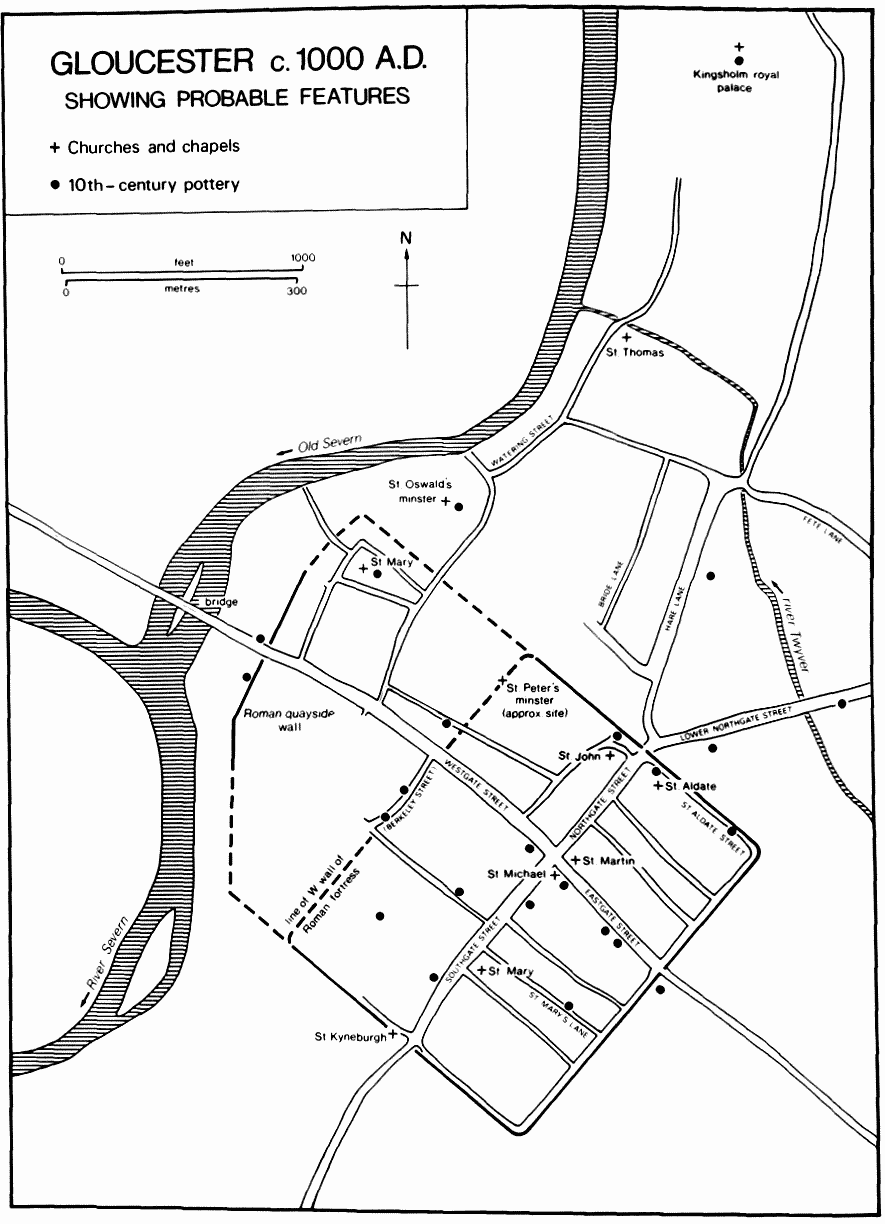
The earliest Roman occupation, the fort built in the 60s A.D. north of Gloucester at Kingsholm, was abandoned after a decade. (fn. 3) The Roman fortress, the precursor of the medieval town, was built in the 70s A.D. in a position commanding the crossing of the river Severn. The river then flowed closer to the town than it does today, in or near the channel later known as the Old Severn and crossed by the Foreign bridge. After the fortress became a colony in the 2nd century, stone walls and gates were provided, as well as a stone quay and quayside retaining wall. The Roman north and east gates survived until the 11th century and the quayside wall until the 12th, while the east, south, and part of the north lengths of the Roman circuit still defended the city in the 17th century. (fn. 4) A suggestion that the riverside retaining wall was, by the 4th century, the western limit of Gloucester's defences has not yet met with general acceptance, (fn. 5) though there is some evidence that the original west wall of the Roman fortress had gone by the 10th century. (fn. 6) The massive public buildings of the Roman town also influenced, though in a less striking way than the walls, the shape of the later settlement.
After the early 5th century the very limited surviving archaeological evidence for Gloucester provides no record of trade or industry and even suggests that until the 10th century or later much of the urban area was used for agriculture. (fn. 7) Gloucester was still, however, regarded as an administrative centre in 577, (fn. 8) and there may have been institutional links between the Roman and the late Anglo-Saxon town. On the Continent, such a connection was provided by the Christian religion, and many late-Roman suburban cemeteries, from being used for Christian burial, acquired chapels which ultimately became parish or even episcopal churches. (fn. 9) At Gloucester it is significant that a Roman cemetery became the site of the late Anglo-Saxon minster of St. Oswald, (fn. 10) and that the church of St. Mary de Lode, which became the parish church for the estates of St. Peter's Abbey around Gloucester, had its origins in a small post-Roman burial chapel or mausoleum, which was aligned, perhaps deliberately, on the Roman house beneath. (fn. 11) Another Roman cemetery, at Kingsholm, which included late-Roman burials of high status, became the site of a late Anglo-Saxon royal palace, whose chapel might, if investigated, prove to have Roman origins. (fn. 12) It is also significant that the remains of the palace complex have a Roman alignment. (fn. 13)
GLOUCESTER c. 1000 A.D.
Besides containing centres of religious significance, post-Roman Gloucester probably kept its reputation and function as an administrative centre. In 577, when it was captured by the Anglo-Saxon invaders after the battle of Dyrham, it was regarded as the head of a district, (fn. 14) and the foundation of a minster c. 679 indicates a similar status. It has been suggested that in 679 the old Roman land tax might still have been in operation. (fn. 15) The fabric of the Roman town was still impressive, but it was decaying and ruined; nothing better demonstrates that than the fact that the Roman street grid vanished entirely. Only the cardinal streets, controlled as they were by openings in the Roman walls, maintained a line that approximated to the Roman grid. Westgate Street diverged more than the others; in the early sub-Roman period it was rerouted through a ruined public building, the columns of which, originally some 30 ft. high, survived for many centuries. (fn. 16) Another surviving feature may have been the open area of the Roman forum. Even in the 10th century buildings in that area had not acquired the alignment of the later street frontage (fn. 17) and the concentration of 9th-century deposits (fn. 18) implies that it was a useful open space.
By the mid 7th century Gloucester had come within the influence of the kingdom of the Hwicce, which passed into the control of Mercia, possibly in 628, with the aid of Northumbrian warlords. (fn. 19) Links with Northumbria are a persistent theme in the history of the town and its shire, culminating in 909 with the translation of the bones of St. Oswald, king of Northumbria, to a final resting place in Gloucester. (fn. 20)
The 9th-century town was not a prepossessing place. Preserved organic material from the forum area demonstrates only domestic and agricultural activity. In contrast to 8th-century mercantile centres such as Southampton, Gloucester received few imports from far afield. The economy, on the evidence, which is admittedly limited, can hardly be termed urban. (fn. 21)
In 877 the remnants of a Danish army camped in the town. (fn. 22) A Mercian council of 896 was held at Gloucester, perhaps in a great hall at Kingsholm, and during the proceedings a priest 'of the inhabitants of the ceastor', presumably meaning the walled Roman town of Gloucester, was mentioned. (fn. 23)
In the 10th century Gloucester acquired, apparently quite suddenly, an administrative and military status which it is tempting to equate with the revival of towns elsewhere in southern England. (fn. 24) Although not listed in the surviving records as a Mercian burh, Gloucester was organized for defence by 914, and the failure of the Mercian register to mention the refortification of Gloucester between 902 and 914 may imply that it was fortified before that period (fn. 25) by Ethelfleda of Mercia. By 909 she had founded in the town the new minster of St. Oswald, a sign of special royal favour towards the town, and by then the town also had a mint. (fn. 26) The royal palace mentioned in the 11th century may have been in existence as the centre of a royal manor, a villa regalis, in the 10th century. When Ethelfleda died at Tamworth in 918 it was not in that traditional centre of Mercia that she was buried, but at Gloucester. (fn. 27)
Ethelfleda's attention to Gloucester may also be demonstrated by the street pattern. There is a striking similarity between the east part of the pattern, with its grid of streets running back to the walls and intramural street, and the burhs of Wessex fortified by Ethelfleda's father Alfred in the late 9th century. (fn. 28) Nevertheless, good evidence is lacking for the date of that street layout. No Gloucester street has a documentary reference before the 12th century, (fn. 29) and archaeological sections produce inadequate or unhelpful dating evidence; for example, the second surface of St. Mary's Lane was of the 12th century. (fn. 30) The distribution of 10th-century pottery (fn. 31) emphasizes the importance of the four principal streets; if the side streets existed, they were not densely built up. There is, however, some evidence that St. Aldate's Street was laid down in the 10th century. (fn. 32) An intra-mural street of that date would strengthen the case for regarding Gloucester as a burh in the Alfredian tradition.
Curiously enough, it is the western part of the town that has produced the best evidence for 10th-century streets. It has been suggested that the Anglo-Saxon burh simply used all the walls of the Roman fortress, (fn. 33) but Berkeley Street, which straddles the line of the west wall of the Roman fortress, is now known to have been laid down during the 10th century, and the extension of the precinct of the old minster westwards across the same Roman line had also occurred by the end of that century. The archaeological evidence so far available suggests that the burh extended to the old course of the river and so was probably defended by the Roman riverside wall, which was not demolished until the 12th century. (fn. 34) How that part of the town was defended to the north and south is not known, but possible lines for the defences are indicated on the plan. (fn. 35) Included in the western part of the Anglo-Saxon burh were houses which were recorded as being destroyed soon after the Conquest to make way for the first Norman castle (fn. 36) and probably also a group of dwellings around St. Mary de Lode church on land belonging to the old minster. (fn. 37) At least two lanes in the lower Westgate Street area adjoining the Old Severn, Myende Lane and Powke Lane, had Old English names. (fn. 38)
As has been suggested, (fn. 39) substantial suburbs were probably built on the north side of the town in the late Anglo-Saxon period. Streets with Old English names existed north of the town on the road to the royal palace at Kingsholm. Hare Lane (from here straet, 'military road') (fn. 40) is assumed to have followed the line of the Roman road out of the north side of Gloucester, though that is not certain. The street layout in the area suggests an element of planning; Hare Lane is a double street, having Back Hare Lane (later Park Street) running parallel, while a third parallel street, Bride Lane, formerly existed further west. (fn. 41) Hare Lane itself has the shape of an extramural market, (fn. 42) with Alvin gate (fn. 43) at its head, though no documentary or archaeological evidence for that has been found.
Also forming part of the northern suburbs in the late Anglo-Saxon period were probably Watering (later St. Catherine) Street running north from St. Oswald's minster and later occupied wholly by its tenants; (fn. 44) lower Northgate Street between the north gate and the northern branch of the river Twyver; and Fete Lane leading between the London road and Alvin gate. (fn. 45)
It has been suggested that the extent of the Anglo-Saxon burh is indicated by those tenements which later paid landgavel. (fn. 46) In a rental of the town in 1455 about the same number of tenements rendered landgavel as c. 1100. (fn. 47) The Gloucester landgavel differs, however, from that in some other towns in that it is not a unitary rent but varies with the value of the property: that may mean that it is a later version of the tax. (fn. 48) Furthermore, the landgavel distribution suggests an 11th- or even 12th-century assessment. For example, it was levied on properties west of the Foreign bridge, an area which both archaeological and documentary evidence suggest was not colonized before the 12th century; the name of the bridge also suggests that it was once the limit of the borough. (fn. 49) It seems that at Gloucester the landgavel payments were altered and updated until the 12th century at least; that they do not represent a pre-Conquest situation; and that the coincidence between the surveys of 1455 and c. 1100 is accidental.
The palace of Kingsholm existed by 1051, and various customary dues rendered in the king's hall and chamber are mentioned in Domesday Book. (fn. 50) It is possible that there was a palace at Gloucester by 896 when the Mercian council met in or near the town. (fn. 51) The later royal manor or liberty of King's Barton seems to have had its origin in an estate which was appropriated to the palace in the late Anglo-Saxon period to supply the royal household with food and administrative services. (fn. 52) A hoard of early 11th-century coins, said to have been found at Kingsholm, was so large that it must represent the taxes of a wide region (fn. 53) and implies a significant administrative centre. Excavations at Kingsholm have uncovered evidence of large timber buildings dating to the 11th century or earlier. (fn. 54)
The old minster of St. Peter, the mother church of Gloucester, was founded by Osric, under-king of the Hwicce, c. 679 and probably had a continuous existence in some form (fn. 55) until it underwent a Benedictine reform c. 1022. (fn. 56) Its church was rebuilt and its site moved in 1058, (fn. 57) but it remained a small establishment until the time of the first Norman abbot, Serlo. (fn. 58) St. Oswald's minster was founded c. 900 by Ethelfleda, Lady of the Mercians, (fn. 59) and in 909 it received the relics of King Oswald of Northumbria. The endowing of more than one of Ethelfleda's royal boroughs with a minster and important relics may have been part of a political policy aimed at conciliation of Mercia during the 'Reconquest' of the Danelaw. (fn. 60) The church was always closely connected with the royal administrative centre at Kingsholm, whose chapel it served. St. Oswald's was later a royal free chapel, and probably had that status from its foundation. Its parish was very large and fragmented and was entangled with the parish of St. Mary de Lode, which itself appears to represent the remnants of the parish of the old minster. The two parishes together, with dependent chapels taken into account, cover a large part of the hundred of Dudstone and King's Barton, and may represent a survival of the original territory with which the old minster was endowed c. 679. (fn. 61)
Without extensive archaeological investigation, it is impossible to tell which of Gloucester's churches were in existence in the Anglo-Saxon period; the earliest documentary record for most of them comes in the 12th century. (fn. 62) There were ten churches by c. 1100, (fn. 63) a total which presumably included those which were technically chapels. A number of the churches may have been recent foundations: even in London very few churches were built before the late 10th century. (fn. 64) The fact that nearly all Gloucester churches acquired burial rights only in the 14th or 15th centuries, if then, is a reminder of the supreme importance of the old minster, which, with its church of St. Mary de Lode, was the parish church of town and suburbs until well after the Norman Conquest. It is clear from a dispute of 1143 about the burial of Miles, earl of Hereford, that the abbey claimed burial rights over the whole town within the walls (as well as the castle precinct), though in that case an exception was made and Miles was buried at Llanthony Priory. By 1197 Lanthony Priory had apparently won partial burial rights over its parishes of St. Mary de Crypt and St. Owen. (fn. 65) The exceptional status of St. Mary de Lode is shown by the fact that it had burial rights by the 11th century. (fn. 66) St. Oswald's minster had burials from its foundation. (fn. 67)
Apart from St. Peter, St. Mary de Lode, and St. Oswald, there were probably other Anglo-Saxon churches, without right of baptism or burial but neverthless maintained by their local communities. The earliest of those churches are likely to be those with the largest parishes and with land outside the town walls, (fn. 68) that is, St. John, St. Kyneburgh, St. Michael, and, probably, St. Mary de Crypt. The centre of a royal estate would certainly have had a chapel, and it is very likely that the chapel at Kingsholm was founded by the time of Edward the Confessor, though there is no documentary evidence for it before the early 13th century. (fn. 69)
St. Mary de Crypt parish lay inside the walls, but an extramural portion may have been assigned by the mid 11th century to St. Kyneburgh. (fn. 70) St. Michael's parish included an extramural area at Barton Street east of the town. St. Mary de Crypt and St. Michael, together with All Saints, a chapel to St. Mary de Crypt, later belonged to the bishop of Exeter (fn. 71) and presumably formed part of an estate that Bishop Osbern held in the town in 1086 and a man called Edmarus before the Conquest. (fn. 72) When St. Michael's church was pulled down in the 1950s excavation produced fragmentary remains of what was almost certainly a Saxon church. (fn. 73) It was in an area of 9th- and 10th-century organic material which had collected in the Roman forum. (fn. 74) The chapel of St. Martin, which belonged to St. Michael's in the 13th century, bore a dedication which suggests that it was another of the early churches. All Saints, which like St. Michael and St. Martin stood at the central crossroads of the town, (fn. 75) has been claimed as a Saxon building, though it could equally well belong to the late 11th century. When it was excavated in the 1890s one of the discoveries was a bear's head in stone which may be Saxon work. (fn. 76)
The chapel of St. Kyneburgh at the south gate was given to St. Owen's church after the Conquest and to Llanthony Priory in 1137. (fn. 77) A mid 12th-century list of the priory's endowments included 'the chapel of St. Kyneburgh and the whole of the parish inside and outside the south gate'. (fn. 78) The wording implies that the parish and chapel were connected. The parish boundary of St. Owen reinforces that impression: it comprised an extramural area and a small area inside the south gate which included St. Kyneburgh's chapel. It seems likely that St. Owen's parish had formerly belonged to St. Kyneburgh, to which a parish may still earlier have been assigned out of that of St. Mary de Crypt. The dedication to the legendary princess Kyneburgh (fn. 79) is clearly apocryphal, but the invention may hide a genuine early dedication to the Kyneburgh who became first abbess of the old minster c. 679. The position of the chapel, sited over the Roman gate, may also imply an early date. Other Roman gates of the town survived until the 11th century (fn. 80) and it is possible that there was an Anglo-Saxon gate-chapel set in the Roman structure. The later alignment, both of the western portion of the chapel and of the almshouses which replaced the rest of it in the mid 16th century, was close to a true east-west alignment (fn. 81) and was not a Roman one, but that is likely to have resulted from a rebuilding of the chapel c. 1147. (fn. 82)
The parish of St. Aldate in the north-east part of the walled area may have housed the 30 burgesses who at Domesday belonged to the church of St. Denis, Paris, (fn. 83) for St. Aldate's church later belonged to Deerhurst Priory, which had been granted to St. Denis by Edward the Confessor. (fn. 84) Its parish boundary, which followed the backs of the tenements on the side streets, was probably not established before the 12th century but the church, in view of its connection with Deerhurst, may well have had a pre-Conquest origin.
The physical appearance of Gloucester in the late Anglo-Saxon period seems to have been that of any small urban community. We know of no stone houses of the 10th and 11th centuries. Domestic buildings were of timber in the 9th and 10th centuries, either built of posts hammered into the ground and interwoven wattle (fn. 85) or of more solid construction. A 10th-century building at the top of Westgate Street incorporated a cellar constructed of a series of upright posts linked by sill-beams. (fn. 86) Such timber cellars were probably more common by the 11th century. (fn. 87) The houses above the cellars were undoubtedly timber-framed, and, like buildings of similar type in other towns, could have had more than one storey. (fn. 88)
It should be possible to chart by the development of crafts and trades the growth of Gloucester from the small, sub-urban or proto-urban settlement of the 9th century to the developed small town which appears in the late 11th century; but insufficient archaeological work has been done. The economy of the 9th-century settlement was purely domestic, including extensive use (and therefore probably manufacture) of wooden objects and leather working. There was no pottery, and no iron nails or other iron objects; by contrast, the late 11th-century town rendered to the Crown a payment of '36 dicras of iron, and one hundred rods of ductile iron for making nails for the king's ships'. (fn. 89) The 10th-century town produced its own pottery, objects of silver, and glass. (fn. 90) Apart from that, economic activity in the town was little different in the 10th century from what it had been in the 9th. The quantity of 10th-century pottery was very small, and its distribution was confined to the principal streets. The true economic upturn seems to have occurred in the 11th century, when pottery becomes more abundant and its types more varied. (fn. 91) It was also in the 11th century that the frontages of the subsidiary streets began to be built up, though only in the 12th do they show signs of being fairly densely occupied. (fn. 92)
It is possible to see as one of the causes of the economic improvement the increase of royal attention. In the 10th century no significant events are recorded after the death of Athelstan at Gloucester in 939, (fn. 93) but 11th-century Gloucester saw a number of royal visits and councils. Edmund Ironside was at Gloucester in 1016 (fn. 94) and Harthacnut came to the town at least once. (fn. 95) Under Edward the Confessor Gloucester was the meeting place of the council nine times between 1043 and 1062. (fn. 96) Those gatherings, some of considerable size, are likely to have been held in the hall at Kingsholm. The strategic importance of Gloucester, the result of the positioning of the original Roman fortress, was also evident in the 11th century. In 1051 Edward the Confessor assembled forces at Gloucester against Godwin's revolt; (fn. 97) in 1055 levies of troops gathered there to meet Earl Alfgar's revolt; (fn. 98) and in 1063 Gloucester was the starting point of Harold's expedition against the Welsh. (fn. 99)
There is, therefore, a contrast between the economic evidence, as provided by archaeology, and the topographical and historical implications of an early 10thcentury foundation. Gloucester in the 10th century was economically a minor centre but the attention of Ethelfleda of Mercia gave it the status and pattern of a burh and provided it with a new minster richly endowed in relics and property. The town had its royal palace and its mint. Its administrative importance is shown by the fact that it became, perhaps by the early 11th century, the shire town. (fn. 100) Like 9th-century Winchester, 10th-century Gloucester had an adminstrative importance belied by its status as judged by trading activity. (fn. 101) The truth seems to be that the patronage of Ethelfleda provided the initial impetus for economic growth, which, though not entirely extinguished by her death, began to bear fruit only a century or more later.