A History of the County of Oxford: Volume 12, Wootton Hundred (South) Including Woodstock. Originally published by Victoria County History, London, 1990.
This free content was digitised by double rekeying. All rights reserved.
'Shipton-on-Cherwell: Introduction', in A History of the County of Oxford: Volume 12, Wootton Hundred (South) Including Woodstock, (London, 1990) pp. 254-257. British History Online https://www.british-history.ac.uk/vch/oxon/vol12/pp254-257 [accessed 26 April 2024]
Introduction
Shipton-on-Cherwell parish covered 1,058 a. on the west bank of the Cherwell, c. 8 miles north of Oxford and c. 2 miles east of Woodstock; it was bounded by minor roads or tracks from Woodstock to Tackley and from Steeple Barton towards Oxford on the west and by a stream and field boundaries on the north and south. (fn. 15) In 1955 it was united with the civil parish of Thrupp, formerly a hamlet of Kidlington, to form the new civil parish of Shipton-on-Cherwell and Thrupp (1,724 a. or 698 ha.). (fn. 16) The following article deals with the parish as it existed until 1955.
A 5-hide estate at Shipton granted to Eynsham abbey in 1005 seems to have extended slightly further west than the later parish. Its boundary, (fn. 17) starting in the south-east corner, ran from the Cherwell westwards, along a small stream, to the southern end of the valley called Shipton Slade. From there it continued westwards along field boundaries to the Wood Way, once part of the road from Steeple Barton towards Oxford and represented in 1984 by a short stretch of the road from Campsfield to Hensington. The 11th-century western boundary ran west of the later one, along a lost way to Bladon and thence to Bigberry, Bica's burh, just south of the point at which Sansom's Lane crosses the Hensington to Tackley road. It then followed another road to the Weaveley boundary. The northern boundary, like that of the modern parish, ran due east back to the Cherwell, which then, as later, formed the eastern boundary.
The change in the western boundary probably took place in the later 11th century or the 12th, perhaps as part of a general reorganization of estate boundaries in the area caused by the creation of Woodstock (later Blenheim) park. (fn. 18) Agreements reached by the lords of the manor with Oseney abbey between 1220 and 1223, in 1261, and in 1263 about rights in the Cherwell and its adjoining meadows in the south-east corner of the parish may have followed a dispute over the exact course of the boundary there. Certainly in 1618 Milham (7 a.) south-east of Shipton church was claimed by both Shiptonon-Cherwell and Hampton Gay. (fn. 19)
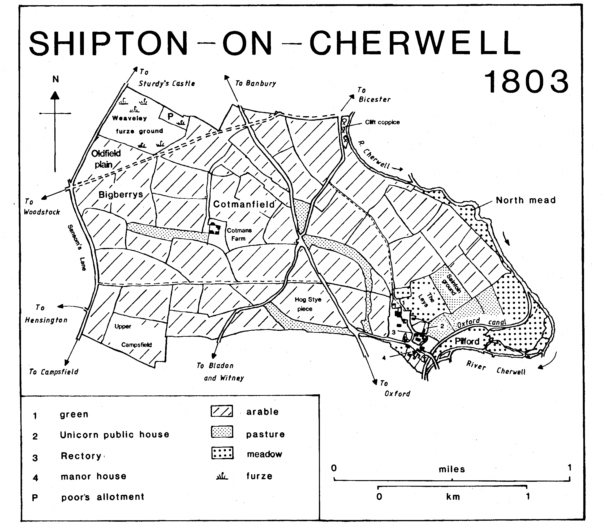
Shipton-on-Cherwell 1803
Most of the parish lies on the cornbrash with the underlying forest marble exposed in the gullies made by three small streams, all of them much reduced by modern drainage and farming methods, which combine to flow into the Cherwill in the south-east corner of the parish. There is some alluvium and river gravel along the Cherwell in the south-east, but in the north the river has cut into the valley bank, forming a steep slope of white limestone of the great oolite series. The stone and gravel have been exploited for cement-making since 1927. (fn. 20) The land rises fairly steadily from 65 m. in the Cherwell valley in the south-east to 100 m. by the Weaveley boundary in the north-west. (fn. 21)
The Banbury-Oxford road, an important early route, runs through the parish; it was turnpiked in 1755 and disturnpiked in 1875. (fn. 22) In the Middle Ages it crossed the stream in the centre of the parish by a rocky causeway which gave its name to Stantebridge, later Stanbridge, furlong. (fn. 23) The Witney-Bicester road, called the ridgeway in the 13th and 14th centuries, (fn. 24) runs across the parish from south-west to north-east; it was turnpiked in 1751 and disturnpiked in 1870. (fn. 25) In the Middle Ages another important route, the Salt Street, crossed the south-west corner of the parish to join the Banbury road just north of Thrupp village. (fn. 26) It had disappeared by the later 18th century. An old road from Woodstock to Bicester survived as a track across the northern part of the parish in the 19th century, (fn. 27) but only the western portion remained in 1984. Minor roads or paths linked Shipton village with Woodstock, Tackley, and Hampton Gay. The Woodstock Way, running almost due west near the southern boundary of the former parish, was marked by a footpath in 1984, as was the road through Pilford (a name meaning the ford over a small stream, presumably the Cherwell) to Hampton Gay. The footpath which had replaced the Tackley road by the later 18th century has been quarried away. (fn. 28)
The Cherwell at Shipton came under the jurisdiction of water bailiffs, presumably the royal officers who controlled the Thames west of Staines, in the 16th and 17th centuries. (fn. 29) A wharf on the Oxford canal, which follows the Cherwell along the eastern and south-eastern boundary of the parish, was opened in 1787. (fn. 30)
The Great Western Railway line along the eastern edge of the parish was opened in 1850; the nearest station, first called Woodstock road and later Kirtlington, was near Enslow bridge, about a mile north of Shipton village. (fn. 31) A branch line to Woodstock was built through the middle of the parish by the Woodstock Railway Co. in 1889 and 1890 and opened in 1890; it was sold to the G.W.R. in 1897. A halt at Shipton, just west of the Banbury road, was opened in 1929. The line was closed in 1954 and the track lifted in 1958. (fn. 32)
Woodstock and Oxford were the markets to which Shipton looked in the 16th century, and no doubt earlier. (fn. 33) No carriers' carts ran from Shipton itself in the 19th century, but presumably carriers from further north stopped in the parish. There was a post office, at Bunker's Hill by the cement works, by 1931. (fn. 34)
In 1867 the only water supply in the village came from a well near a pigsty, and even that sometimes dried up in summer. Mains water was supplied c. 1947. (fn. 35) Gas reached the village in 1924. (fn. 36)
Two long barrows survived in the north of the parish, near the Banbury road, until c. 1970, and there were traces of three other possible barrows in the same area; the medieval field names angelowe, Littelowe, Brokenlowe, and Coppedelowe referred to those or other nearby barrows. (fn. 37) There was a Romano-British settlement, occupied from the 2nd to the 4th century, on the patch of gravel north of the modern village, and a few Anglo-Saxon finds have been made in the same area. (fn. 38)
Field names, combined with the archaeological evidence, suggest a number of small, scattered settlements in the parish in the earlier Anglo-Saxon period, some of them extending into neighbouring parishes. Bica's burh, on the western boundary, was presumably a small fortification, perhaps simply a fortified house. The personal name Bica implies that it dated from the 9th century or earlier, (fn. 39) and it may already have been deserted when it was recorded on the estate boundary in 1005. Immediately north of Bigberry was an area called the Old field, part of which was later in Weaveley in Tackley parish, (fn. 40) which may have been associated with the burh. East of Bigberry, on or near the stream which flows past Shipton Slade Farm, was Sititrop or Fititrop, recorded as a field name in the 1220s, 1310, and 1623. (fn. 41) The first element is obscure, but the second is 'throp', a farm or hamlet. Two furlong names ending in 'ton', Walton recorded in the 13th and 14th centuries and Hilton not recorded until 1588, (fn. 42) may also mark early farmsteads or hamlets, although the meaning 'inclosure' is also possible. The first element of Walton, which lay somewhere near the junction of the Banbury and Bicester roads, might be 'waelle', a well or stream, which would fit the topography, or 'weala', 'of the Britons' or 'of the (British) serfs'. (fn. 43) Hilton was on high ground further north, just west of the Banbury road. No trace of any of those settlements or possible settlements survives on the ground, nor is there any evidence of early inclosures except around the later village.
By the beginning of the 13th century, if not earlier, settlement was concentrated on or near the site of the modern village, the remainder of the parish, except for areas of permanent grass at Campsfield in the south-west and Old Field plain in the north-west, being divided into arable fields. (fn. 44) In 1086 a total of 11 unfree tenants and 8 servi was recorded on the two Shipton manors. (fn. 45) There are no 13th- or 14th-century surveys of the parish, but the names of 21 landowners or occupiers in the 1240s can be recovered from terriers in St. John's hospital deeds, and 20 heads of households had enough goods to be assessed for subsidy in 1316. (fn. 46) Only 43 adults paid poll tax in 1377, and there had been little if any increase in population by 1642, when 23 men over 18 took the protestation oath, or by 1676 when there were 45 adults in the parish. (fn. 47) Eighteenth-century curates reported between 15 and 18 houses and cottages, and in 1801 the population of 106 occupied 18 houses. (fn. 48) The population rose sharply from 104 in 1811 to 147 in 1821 and then remained fairly steady until the last quarter of the 19th century when it began to fall, reaching a low point of 71 in 1891. (fn. 49) There were no outlying farms until after inclosure in 1768 when Cotman Farm, later Shipton Slade Farm, was built near the site of an earlier field barn; three labourers' cottages were built near the farmhouse c. 1860. (fn. 50) The opening of the cement works in the parish in 1929 increased the population to 166 in 1931 and to 264 in 1951, the last year for which separate figures are available. The population of the new civil parish of Shipton-on-Cherwell and Thrupp in 1971 was 402. (fn. 51)
Shipton-on-Cherwell village lies in the extreme south-east of its parish, approached by a narrow lane from the Banbury road; unlike the Thames valley villages to the south it is built on cornbrash, although there is a patch of gravel a short distance to the north. Most of the houses are mid 20th-century council houses. The church stands on the top of a steep slope above the Oxford canal which there follows a minor stream of the Cherwell; it always marked the south-east edge of the village. Both manor houses stood near it, the surviving Shipton Manor to the west, the lost Scorchbeef's Manor to the north-west. In the 17th-century there was at least one house on the south side of the lane to the Banbury road, west of Shipton Manor, and several others on the north; the village then also extended considerably further on the north-east than later, along both sides of a road to Tackley. It had probably been even larger in the Middle Ages. (fn. 52) In 1662, when 13 householders paid tax on 40 hearths, there was at least one substantial house, taxed on five hearths, in addition to the manor house and the rectory house; it may have been the one occupied by Thomas Rathbone's nephew in 1612. (fn. 53) There was a green on the north or north-east edge of the village from the 16th to the 19th century and probably also in the Middle Ages, as the surname at Green was in use before 1234. (fn. 54)
The only 19th-century additions to the village were a bailiff's house on its northern edge and the school and school-house on the east side of the north-south street, all built shortly before 1862. (fn. 55) In 1867 most of the 21 cottages in the village were very poor, 15 of them having only two rooms, and the poor housing combined with the unsatisfactory water supply resulted in outbreaks of typhoid fever. (fn. 56) Three cottages were declared unfit for human habitation in 1913, (fn. 57) and all but one or two of the 19th-century cottages had gone by 1984. Sixteen semidetached council houses were built north of the village in Jerome Way in 1947-8, and another 34 were built in 1953. (fn. 58) In the late 1920s the Shipton Cement Co. built 18 houses at Bunker's Hill for its workers. (fn. 59) One public house, the Unicorn or the Unicorn's Head, was recorded from 1782 until 1807; it stood in the village, just north of the rectory house. (fn. 60)
The water-colour painter William Turner of Oxford spent some time in Shipton-on-Cherwell after his uncle and guardian, William Turner, bought the manor in 1804. The younger William was married in Shipton in 1824 and buried there in 1862. (fn. 61) In a major railway accident at Shipton in 1874, the crowded London to Birmingham express was derailed as it crossed the Cherwell just east of the village. Several carriages plunged down a steep embankment into the meadows between the river and the canal, killing 34 people and seriously injuring a further 65. (fn. 62) An 'Oxfordshire Historical Pageant' performed in the manor house grounds in 1931 included scenes by John Buchan and A.L. Rowse. (fn. 63)