A History of the County of Oxford: Volume 12, Wootton Hundred (South) Including Woodstock. Originally published by Victoria County History, London, 1990.
This free content was digitised by double rekeying. All rights reserved.
A P Baggs, W J Blair, Eleanor Chance, Christina Colvin, Janet Cooper, C J Day, Nesta Selwyn, S C Townley, 'Cogges: Introduction', in A History of the County of Oxford: Volume 12, Wootton Hundred (South) Including Woodstock, ed. Alan Crossley, C R Elrington (London, 1990), British History Online https://www.british-history.ac.uk/vch/oxon/vol12/pp54-59 [accessed 9 May 2025].
A P Baggs, W J Blair, Eleanor Chance, Christina Colvin, Janet Cooper, C J Day, Nesta Selwyn, S C Townley, 'Cogges: Introduction', in A History of the County of Oxford: Volume 12, Wootton Hundred (South) Including Woodstock. Edited by Alan Crossley, C R Elrington (London, 1990), British History Online, accessed May 9, 2025, https://www.british-history.ac.uk/vch/oxon/vol12/pp54-59.
A P Baggs, W J Blair, Eleanor Chance, Christina Colvin, Janet Cooper, C J Day, Nesta Selwyn, S C Townley. "Cogges: Introduction". A History of the County of Oxford: Volume 12, Wootton Hundred (South) Including Woodstock. Ed. Alan Crossley, C R Elrington (London, 1990), British History Online. Web. 9 May 2025. https://www.british-history.ac.uk/vch/oxon/vol12/pp54-59.
Introduction
COGGES lies 9 miles (15 km.) west of Oxford and ½ mile (0.4 km.) east of Witney. (fn. 20) The ancient parish formerly covered 2,285 a. (920 ha.); it included the residual medieval urban plantation at Newland, effectively a part of Witney, and, on the east, the hamlet of High Cogges. Wilcote, to the north, although a separate ecclesiastical parish from the Middle Ages, was a hamlet of Cogges for civil purposes until the mid 19th century. In 1932 Cogges civil parish was dissolved and divided between Witfney (225 a.), South Leigh (878 a.), and Ducklington (1,182 a.). (fn. 21)
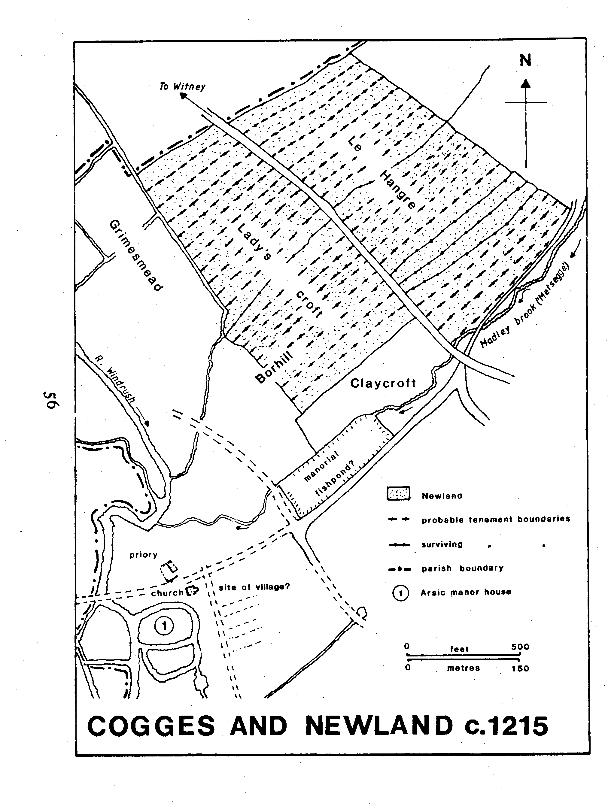
The ancient boundaries corresponded in places to those described in charters for the adjoining manors of Witney in 969 and 1044 and Eynsham in 1005, and in a perambulation of Wychwood Forest in 1298. (fn. 22) The long, sinuous east boundary, called 'the way' in 1005, is in places deeply sunk and embanked, and may be a prehistoric or Roman trackway leading southfwards from the ford at Ashford Mill on the river Evenlode to Gill Mill on the river Windrush; (fn. 23) from Gill Mill a probable Roman road runs south-westwards through Cokethorpe Park towards Bampton. (fn. 24) On the north, the boundary followed the northern perimeter of Cogges wood; from the west corner of Osney Hill, it ran south-west along Madley brook, Madley Lane, and field-boundaries to Witney, and thence south-east along the Windrush to Gill Mill at the southern tip of the parish.
The parish lies mainly on the Oxford Clay, rising to 110 m. in the centre of the parish between High Cogges and Newland. The central eminence perhaps suggested the form of a wheel (O.E. *cogg?), giving the parish its otherwise unintelligible name. (fn. 25) The clay declines westwards to bands of gravel and alluvium bordering the Windrush; the church, priory, and manor houses stand isolated on the edge of the parish beside the river, on a small Cornbrash island in the floodplain. (fn. 26) In 1797, (fn. 27) as in 1987, the only substantial area of woodland was Cogges wood in the north-east. River meadows run along the parish's entire south-western edge.
The Witney-Bladon road, an important Anglo-Saxon route called the port way in 1005 and Woodstock way in 1299, (fn. 28) skirted the parish on the north. Another ancient west-east road, from Witney to Eynsham, may once have traversed the two Cornbrash islands of Witney and Cogges, one of the narrowest crossing points in the Windrush floodplain; (fn. 29) its line runs to Cogges over a footbridge which may be the site of the 'Tidreding ford' mentioned in 969. (fn. 30) The route was insignificant after the early 13-th century, (fn. 31) but the presence of an early major crossing may explain the scale of the 12th-century manorial buildings. The later medieval road, called via regalis in 1212-13, (fn. 32) ran from the north end of Witney through Newland and thence eastwards to Eynsham. That and the Witney-Bladon road were both turnpiked in 1751; the tollgate for the Eynsham road stood at Newland at the bottom of Cogges hill, near Madley brook, and in the 20th century the road survived as the main trunk road from Oxford. (fn. 33) From Newland a valley-side trackway followed the Windrush terraces southwards towards Stanton Harcourt; it seems to have crossed the Thames at Bablock Hythe and continued to Abingdon, and was called Abingdon Lane by 1599. (fn. 34) At inclosure in 1787 it was confirmed as a public highway; (fn. 35) its earlier course is probably represented by the former farm track connecting Manor Farm with the later road. By the 18th century it was linked with the heath and with the Witney to Bladon road on the north by a winding road through High Cogges village, also confirmed at inclosure. (fn. 36) Clay Street, mentioned in the 16th and 17th centuries, ran east from near Shores Green into South Leigh, and may have been connected with the possible Roman or prehistoric trackway running along the boundary; the modern road from Shores Green to South Leigh was apparently newly laid out across the heath at inclosure. (fn. 37)
A network of paths, many of which continued after inclosure, linked the villages with the heath and with Cogges wood on the north, with Hill Houses on the east, with Gill Mill and the river Windrush on the south, and with the surrounding parishes; in 1212-13 Newland tenants had right of way through North field to Cogges wood along the line of Madley brook. (fn. 38) The road through Cogges village, formerly passing south of the churchyard, was redirected in 1860 to pass north of the priory house, crossing the Windrush c. 200 yd. north of the former crossing. (fn. 39)
There was a post office in Newland by 1864. (fn. 40) The Witney branch of the West Midland Railway, later part of the G.W.R., was built across the parish in 1861, the nearest station being at Witney; the line was closed to passenger traffic in 1962 and to goods traffic in 1965, and was dismantled by 1971. (fn. 41)
Neolithic material has been excavated near Manor Farm and the priory. (fn. 42) Aerial photography has revealed several Bronze Age and Iron Age sites near the north-west and south-west boundaries of the parish, including a line of ploughed-out round barrows, (fn. 43) and a bronze palstave has been found near Newland. (fn. 44) A ditch south-west of High Cogges, cutting off the spur of Spring hill, has been interpreted as remains of an Iron Age promontary fort. (fn. 45) A substantial Romano-British settlement site near Gill Mill has yielded some 2,000 coins, metal objects, and building debris; (fn. 46) several urns said to be of Upchurch Ware have been found near Northfield Farm. (fn. 47) A cropmark site immediately south of the Cornbrash island, including two rectilinear buildings, may be Anglo-Saxon. (fn. 48) Finds of pottery suggest that the Cornbrash island was settled for much of the Anglo-Saxon period. (fn. 49)
Cogges and Newland c.1215
Cogges c.1250
In 1086 only 3 servi were listed, other inhabitants perhaps being omitted accidentally. (fn. 50) In 1279 there were 38 tenants on the two manors. (fn. 51) In 1377 the poll tax was paid by 92 people in Cogges and Wilcote, (fn. 52) which suggests that 14th century depopulation may have been below the Oxfordshire average. There were 25 contributors to the subsidy of 1524 and 160 communicants in 1547, and 79 adult males swore the Protestation Oath of 1642; 158 men and women were noted in 1676, although a few probably lived at Wilcote. (fn. 53) There were said to be 80 households in 1759, 74 in 1768, and c. 70 in 1774; (fn. 54) by 1801 there were 66 houses inhabited by 70 families at Wilcote and Cogges, the total population being 343 of whom c. 10 lived at Wilcote. The population fell before 1811 but thereafter grew rapidly; in 1821 it was 452 and by 1851 had reached 814, the increase being attributed to the success of the blanket and glove industries. As in many Oxfordshire parishes the population declined rapidly in the later 19th century and by 1871 was only 664; thereafter it again rose, reaching 790 by 1901 and 888 in 1911. In 1951 the population of the ecclesiastical parish, with almost the same boundaries as the former ancient parish, was 809. (fn. 55)
The main settlement of Cogges was the closegrouped cluster of the church, the priory, and two manor houses. The exceptional character of the group resulted mainly from 12th and 13th-century manorial developments described below. (fn. 56) A small planned town, Newland, was built in 1212-13. The existence of a medieval nucleated village remains unproven; traces of earthworks south of Manor Farm and extending into its curtilage may represent a deserted medieval village, (fn. 57) and it is possible that tenants were moved from there during the 13th-century rearrangements.
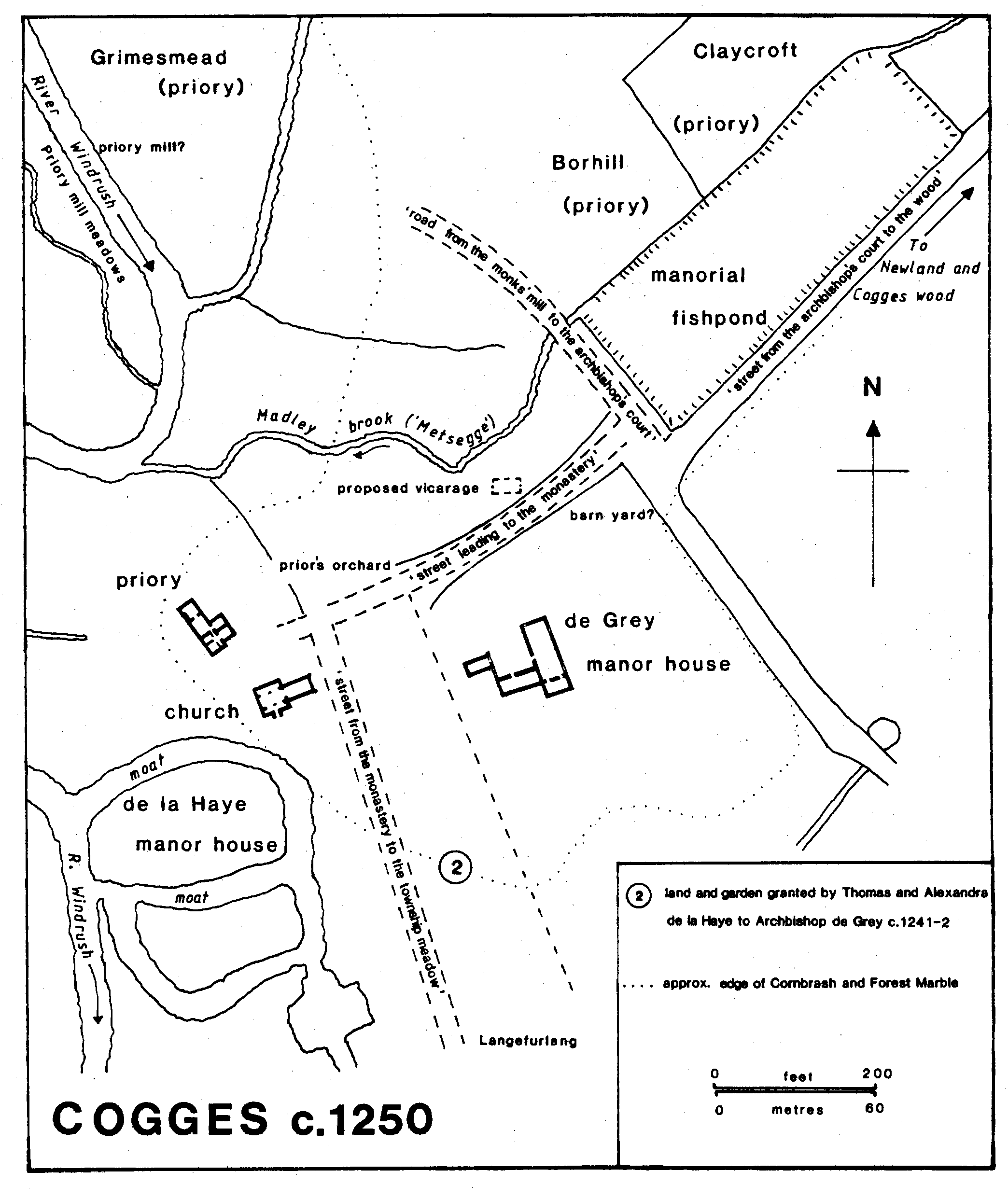
The 11th-century manor house, which Manasser Arsic gave to Fecamp abbey c. 1100 to provide a site for the priory, lay immediately north of the church. (fn. 58) Two oval moated enclosures south-west of the church evidently mark the castle or manor house of the Arsics and the caput of their barony between c. 1100 and c. 1230. In the 17th century foundations were frequently dug up in a ground south of Cogges church called Castle Yard, (fn. 59) and massive 12th-century foundations have been excavated on the northern moated site. (fn. 60)
Another manor house, later Manor Farm, probably originated with Archbishop de Grey's purchase of half the manor in 1241; it was called the archbishop's court in 1242. (fn. 61) The older, moated site remained the capital house of the other half of the manor, and was still called the court of Cogges in 1279; (fn. 62) it may have been abandoned when the manor was reunited in 1338. A royal confirmation of the archbishop's holdings in Cogges in 1242 (fn. 63) described the boundaries of land west of Manor Farm and of the large manorial fishpond to the north-east. The fishpond, mentioned in 1232-3 as the eastern boundary of a proposed vicarage house, (fn. 64) is rectangular with large banks; the banks partly survived house building in 1984, when excavation showed them to be post-medieval in their present form. (fn. 65) Manor Farm (fn. 66) contains a 13th-century range (now the hall, though not necessarily so from the outset) with an original door and window, perhaps built by Archbishop de Grey. There are traces of another medieval range at right angles to it, and the original house apparently had a courtyard plan; the dairy, which abuts a third side of the courtyard, is also medieval in origin, and remains of a fourth range were excavated in 1989. In the early 16th century the hall was floored over, reroofed, and given a substantial double screen and a wall fireplace. In the late 17th century the Blake family added a large east wing. There are extensive farm buildings of the 17th to 19th century. (fn. 67)
Cogges priory (fn. 68) was the English cell of Fécamp abbey between c. 1100 and the late 14th century. By the late 12th century it was nonconventual and functioned mainly as an estate office, from which the priorbailiff with one or two companions administered Fecamp's English assets. The early 12th-century buildings, which were possibly on a claustral or quadrangular plan, were derelict in the 1150s and replaced soon afterwards by a storeyed chamber-block. A small open hall and service-rooms were added in the mid 13th century. After the confiscation of the priory the building fell into decay; in the early 17th century part was remodelled as a farmhouse, with separate rooms for the parochial chaplain. (fn. 69)
In 1212-13 the lord of Cogges, Robert Arsic, founded Newland, a small planned town of a familiar early 13th-century type. (fn. 70) He divided 40 a. of his demesne between 26 named tenants, who were to build a house on each acre and pay for it 3s. on entry and 1s. yearly thereafter. (fn. 71) Since several tenants held more than one acre each it seems likely that they intended to develop and sublet the land, and at least one, Robert, chaplain of Westbury, was almost certainly non-resident. The development was clearly stimulated by the growth of nearby Witney, but unlike Witney it failed: only seven of the 1s. rents may be identified in 1279. (fn. 72) By the mid 18th century there were only a few houses scattered along the street. (fn. 73) The land lay on either side of the royal road from the bishop of Winchester's land, which presumably lay in Witney parish at the north-west end of Newland; 20 plots on Lady's croft, partly next to the bishop's land, and on 'Borhill' (the Burrell close of 1776 and immediately north of the manorial fishpond) (fn. 74) were evidently along the south-west side of Newland street, and 20 in the croft called 'le Hangre' were presumably along the north-east side. Forty strips of c. 1 a. each would have fitted into the available space, and two on the north-east side survived in 1982. (fn. 75)
In 1219-20 the bishop of Winchester acquired part of Cogges priory's Grimesmead, a transaction evidently associated with a rent of 16s., first collected by the bishop that year, 'from 16 messuages in the meadow next the bridge towards Cogges'. (fn. 76) The tenements, presumably those over the parish boundary south-east of the road from Witney bridge to Wood Green, and which backed onto Grimesmead, clearly represented an extension of Witney to link with its neighbour Newland; such developments on both sides of the Windrush may explain the replacement of the direct west-east road through Cogges in favour of the more northerly route through Newland.
There is no evidence for the existence of a hamlet at High Cogges during the Middle Ages, and the village may have originated later as a group of farmsteads on the edge of the heath: in 1604 a small cottage built on the common illegally, perhaps near High Cogges, was allowed to remain. (fn. 77) The village was presumably well established by 1695 when a school was founded there, (fn. 78) and several surviving buildings are 17th-century, including, north of the village street, the north range of High Cogges Farm and the nearby stone granary, and south of the street the cottage called nos. 9-10. By the mid 18th century High Cogges was larger than Cogges; there were then several labourers' cottages and other buildings, many of them later demolished, along both sides of the village street, and there were cottages on the heath west of the road from High Cogges to Shores Green. Most buildings are of coursed limestone rubble with stone slate roofs, although Ladymead Cottage and nos. 9-10 are thatched. In 1829 most of the labourers' cottages attached to Great High Cogges farm were said to be hardly worth repairing. (fn. 79)
There were outlying farmhouses on or near the sites of the later Springhill, Northfield, and Clementsfield Farms by 1767; (fn. 80) Clementsfield may be identical with the earlier Flemingfield, on which a house was built c. 1600. (fn. 81) Following inclosure in 1787 most farms remained centred on existing homesteads. (fn. 82) Springhill Farm was largely rebuilt in the mid 19th century, and extensive repairs and additions were made at Clementsfield Farm c. 1882. (fn. 83) Cholsey Farm was newly built after 1833, (fn. 84) but most new building was confined to Newland, where a large number of stone-built terraced houses were built along the Oxford road in the 19th century to house the rising population employed in the Witney blanket industry and other urban occupations; by then Newland effectively formed part of Witney. (fn. 85) Newland House, on the south side of Oxford road, was built in the late 18th or early 19th century, and was later the home of the Early family of Witney. (fn. 86) Other houses were built in the earlier 19th century along the newly established Witney to South Leigh road, including those later called Broad View, April Cottage, and Field View; adjoining buildings associated with a smithy and agricultural implement works were added later in the century, but have since been demolished. (fn. 87)
The water supply, even at Newland, was from wells until the early 20th century. (fn. 88) By 1939 water was supplied by Witney Urban District Council, and gas and electricity were available, but in the late 1940s some houses on Church Lane, between Cogges and Newland, still had only gas lamps and standpipes and no mains sewerage. (fn. 89)
The site of the Hare and Hounds, mentioned in the 1730s and 1740s, (fn. 90) is unknown. In 1775 there were three public houses, the Star, the Crown, and the Axe, and by 1780 there were six, including the Crown, the Axe, the George, the Swan, and the Plasterers' Arms. At Newland, the Griffin was so named by 1786, and the Carpenters' Arms by 1822; from the early 19th century they were the only two public houses in the parish. (fn. 91) In the later 19th century Cogges vestry met at the Carpenters' Arms. (fn. 92)
In the late 1970s and 1980s large housing estates were built on agricultural land immediately east, north, and south of Cogges village, extending from Newland on the north to Spring hill and the Witney bypass on the south; the road from Stanton Harcourt was redirected to skirt the eastern edge of the estates, joining the Oxford road near Gibbets Close Farm. (fn. 93) Building continued in 1988, and there was infilling at High Cogges and along South Leigh Lane.
In 1974 the Oxfordshire County Council opened Manor Farm and its outbuildings as a museum of farming and rural life in Edwardian Oxfordshire.