A History of the County of Wiltshire: Volume 15, Amesbury Hundred, Branch and Dole Hundred. Originally published by Victoria County History, London, 1995.
This free content was digitised by double rekeying. All rights reserved.
'Parishes: Wylye', in A History of the County of Wiltshire: Volume 15, Amesbury Hundred, Branch and Dole Hundred, (London, 1995) pp. 295-305. British History Online https://www.british-history.ac.uk/vch/wilts/vol15/pp295-305 [accessed 11 April 2024]
In this section
WYLYE
Wylye village is half way between Salisbury and Warminster, 15 km. from each. (fn. 1) The parish, 2,314 a. (936 ha.) until 1934, lies north—south across the Wylye valley with the river flowing from west to east across its middle. It contains the land of Wylye and of Deptford, that of each forming a strip, Deptford's to the north and, twice as wide, Wylye's to the south. (fn. 2) In 1934 the half of Fisherton de la Mere parish containing Fisherton de la Mere village but not Bapton village was transferred to Wylye parish, (fn. 3) thereafter 1,608 ha. (3,974 a.). (fn. 4)
The boundaries of Wylye's land were defined c. 940 and have evidently been little changed; the east boundary of Deptford's land was apparently defined c. 977 and possibly its whole boundary in 988. For much of its length the parish boundary crosses downland and ignores relief and man-made features, but in the extreme south it is marked by an ancient ditch, in the south-east crosses a prehistoric earthwork and follows a coomb and an ancient track, (fn. 5) in the north-west follows another coomb for 800 m., and in the extreme north is marked by a road. In the centre of the parish the river is the boundary with Steeple Langford and for a short distance was with Fisherton de la Mere.
Chalk outcrops over the whole parish. Deposits of clay-with-flints cover it in the extreme south, and wide bands of gravel and alluvium have been deposited across the middle where the Wylye falls no more than 5 m. On each side of the river a tongue of gravel projects into a coomb. The chalk downs reach 198 m. in the south-east, 163 m. on the north boundary. Where it marks the boundary to the east the Wylye is below 70 m. Although they are broken by coombs the downs to both north and south have some flat land on them. (fn. 6)
Land use in the parish was characteristic of the Wylye valley with meadow land on the alluvium, watered from the 17th century to the 20th, settlement sites on the gravel, open fields on the gravel and on the chalk nearer the villages, and extensive pastures on the steeper and further chalklands. Wylye village had more land than most other villages in the Wylye valley and two distinct sets of open fields developed on it, each perhaps of average size for the valley. Some of Wylye's downland was ploughed from the 18th century, some of Deptford's from then or later. (fn. 7) In 940 Wylye was allotted limited rights to take timber from Grovely forest and elsewhere, (fn. 8) suggesting that it then had little woodland of its own; in 1086 Wylye had only 10 a. of coppice wood, Deptford no woodland; (fn. 9) there was no extensive woodland in the later 16th century. (fn. 10) The parish had only 1 a. of woodland c. 1840, (fn. 11) c. 15 a. c. 1918. (fn. 12) Several coverts were later planted on Deptford's downs. Despite having little woodland the part of the parish south of the Wylye and east of the Wylye—Dinton road was in Grovely forest as defined in 1219: it was disafforested in 1300. (fn. 13) The west lodge of the forest may have been in the parish. (fn. 14) The Wylye has long been valued for its fish, and in the later 15th century or early 16th cygnets were reared on an island in it. (fn. 15)
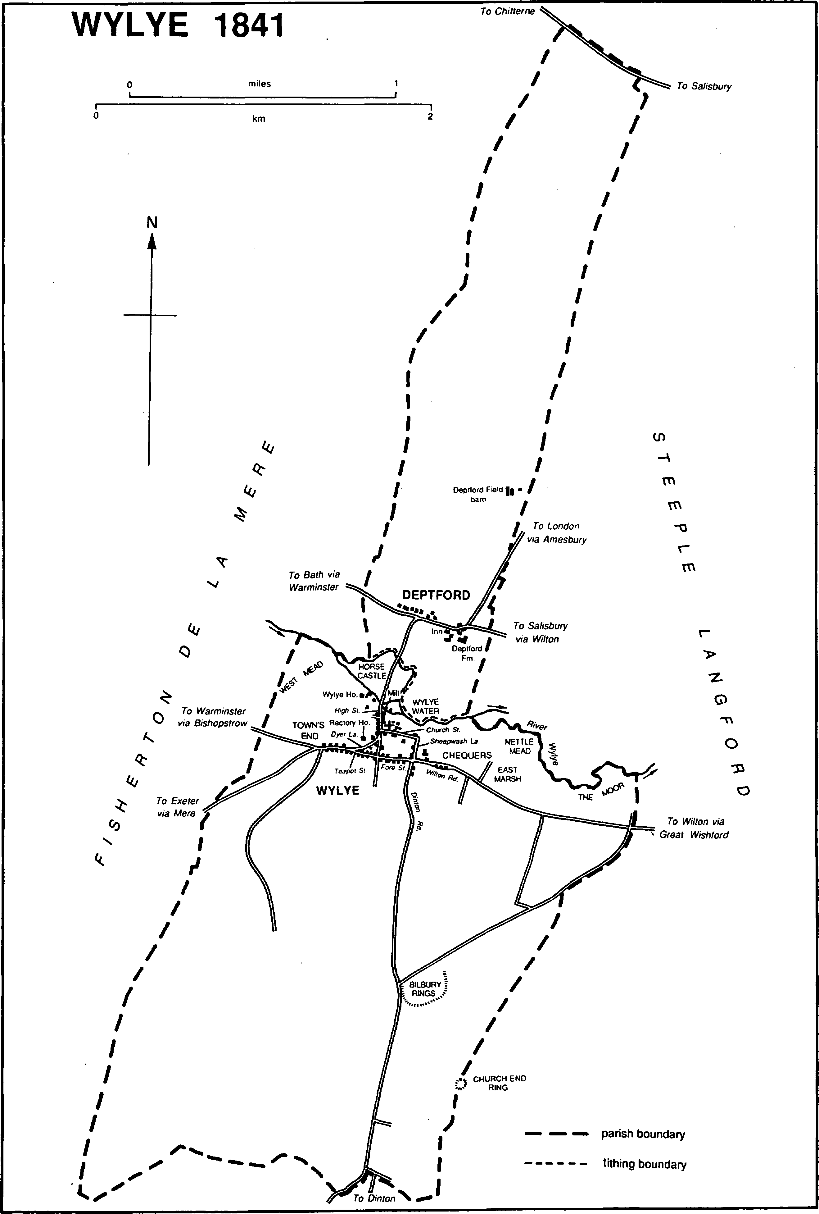
Wylye 1841
Three short stretches of a Roman road from Winchester and Old Salisbury to the Mendips possibly crossed the extreme south of the parish; (fn. 16) the Grovely ridge way on the Wylye—Nadder watershed may also have crossed the parish there; the ancient Harrow way, thought to have linked Kent and Somerset, may have kissed the south-east corner; (fn. 17) a downland road between Wilton and Mere kissed the south-west corner; and the road along the northern parish boundary branched from what was until the 18th century the main Salisbury—Bath road and led to Chitterne. (fn. 18) The downland road between Amesbury and Mere crosses the parish from north-east to south-west through both Deptford and Wylye: it was called the London roadway c. 1600, (fn. 19) London way in 1669, (fn. 20) and was apparently an important route long before it was turnpiked in 1761. (fn. 21) The parish was ordered to repair it in 1736. (fn. 22) At the north end of Wylye village it forded the Wylye at Wylye water east of the mill as late as 1742; (fn. 23) a bridge was built west of the mill before 1773, (fn. 24) presumably when the road was turnpiked. That bridge was replaced in 1964. (fn. 25) A statue in Wylye water allegedly commemorates the drowning of the conductor of a coach which crashed when fording the river there. (fn. 26) South-west of the village a hollow way beside the road (fn. 27) may have marked its pre-1761 course, and in 1856 a new section, with a sharp bend, was made to bridge the new railway. (fn. 28) The road was disturnpiked in 1871. The Wilton—Warminster road on the left bank of the Wylye crosses the Amesbury—Mere road at Deptford: as part of a Salisbury—Bath road it was turnpiked in 1761, disturnpiked in 1870, and in the 20th century it was the main Southampton-Bristol road. (fn. 29) For 300 m. the two roads shared a course. Both were designated trunk roads, the Amesbury—Mere road in 1958 as part of the main London—Exeter road, the Southampton—Bristol road in 1946, and in 1975 their junction was reconstructed: (fn. 30) both were remade as dual-carriageway roads, the Southampton—Bristol road to bridge the London—Exeter road which was diverted away from Wylye village, and several slip roads were made. The parish is also crossed by the Wilton— Warminster road linking the villages between Great Wishford and Bishopstrow on the right bank of the Wylye, turnpiked between Little Langford and Stockton in 1761 and disturnpiked in 1871. (fn. 31) In the south-west part of Wylye village that road too shared a course with the Amesbury—Mere road until in 1975 it was bridged by the new road. A toll house (fn. 32) survives in the shared section. A road leading south from Wylye to Dinton was apparently on its present course in 1219: (fn. 33) a straight section was made across the downs at inclosure c. 1843. (fn. 34) The road on part of the south-east boundary led across Wylye's downs towards Chilmark but went out of use between the late 18th century and the late 19th. (fn. 35)
In 1856 the Salisbury—Warminster section of the G.W.R. was opened across the parish, parallel to and a little south of the minor Wilton—Warminster road, with a station west of Dinton Road. New sidings and loading platforms were built east of that road in the First World War. (fn. 36) The station was closed in 1955. (fn. 37)
Artefacts from the Mesolithic and Neolithic periods and from the Bronze Age have been found in the parish, and there are barrows on the downs of both Wylye and Deptford. To the south Bilbury rings and, on the south-east boundary, Church End ring are Iron-Age settlements which remained in use in the Roman period: nearby field systems of 80 a. and 250 a. were in use as long as the settlements. Along the south boundary Grim's ditch is probably later than the Roman road. (fn. 38)
In 1377 the parish had 112 poll-tax payers (Wylye 86, Deptford 26). (fn. 39) The population was 352 in 1801. It rose rapidly to reach 466 in 1821, was over 500 in 1841 (Wylye 421, Deptford 87), 1851, and 1871, but from 1871 declined. In 1931 it was 313. The decline apparently continued: the enlarged parish had 400 inhabitants in 1951, (fn. 40) 311 in 1981. New housing in the 1980s caused a rise, to 409 in 1991. (fn. 41)
Wylye.
Its name suggests that Wylye was one of the earliest settlements in the valley. It presumably originated where the church, the site of the demesne farmstead east of it, and the demesne mill are in the north part of the village near the river. (fn. 42) Other settlement was in a small grid of streets. North-south are High Street and east of it Sheepwash Lane and Dinton Road; east-west are Church Street and Fore Street. None of the names seems to be older than the 19th century. The development of the grid can be conjectured. The first lands assigned to customary tenants, possibly before 940, were in the west part of the tithing, and evidence from the 16th century and later suggests that they were worked from tenements built on the line of High Street. Lands assigned later were in the east and evidence suggests that some were worked from tenements on the line of Sheepwash Lane. (fn. 43) Each line may have tended to assume an identity as a separate settlement, possibly those alluded to by the names Abbess Wylye and Wylye by Langford c. 1567: (fn. 44) the church was to the west, and the cross which stood in the village from before 1219 to after 1589 was to the east, apparently at the north end of Sheepwash Lane. (fn. 45) The west-end holdings were larger than those of the east end, (fn. 46) and several substantial farmhouses stood in High Street. About 1626 the demesne farmstead was replaced by or converted to a row of eight small farmhouses east of the church on the line of, but set back from, Church Street. (fn. 47) The division of the demesne between eight equally sized farms, each with a farmhouse in the row, adds weight to the conjecture as to how the village developed earlier. Also in the 17th century farmhouses were built, perhaps for the first time, in Fore Street, where long and narrow plots on the north side suggest a subdivision. (fn. 48) By the mid 18th century settlement had extended west of Fore Street into Teapot Street, and cottages had been built on the waste there and further west at Town's End; (fn. 49) east of Fore Street in Wilton Road cottages had been built on the waste at Chequers by 1773, (fn. 50) and a farmstead had been built by 1794. (fn. 51) High Street was the course of the Amesbury—Mere road, and Fore Street that of the minor Wilton— Warminster road: (fn. 52) the two roads may have shared Teapot Street until, before 1742, (fn. 53) Dyer Lane was made to take the Amesbury—Mere road away from it to the west.
In High Street 6–8 substantial farmhouses survive, some having been used as inns. The oldest is apparently that at the junction with Dyer Lane, which is partly timber-framed, partly of ashlar, and late 16th- or early 17th-century in origin. Alehouses were kept at Wylye in the 16th century, (fn. 54) presumably on the main road in High Street, where later there were four inns. The Green Dragon was built shortly before 1631: (fn. 55) it was later on the west side near the north end in Down House, which was extensively altered in the earlier 18th century. The Bull, which had a malthouse, was on the east side at the north end, was open in 1696 (fn. 56) and 1736, (fn. 57) and, like the Green Dragon, was apparently closed before 1796. (fn. 58) The White Lion, opposite the west end of Church Street, was open in 1782 and 1796 (fn. 59) but was replaced by a pair of cottages, of brick and flint in bands, dated 1838. The Bell, in a building of the earlier 17th century immediately west of the church, was first mentioned in 1684 (fn. 60) and was open in 1991. The other surviving farmhouses in High Street are mainly 17th- and 18th-century, and one has chequered walling. In the south part of the street a large house was built in the early 19th century; in the middle on the east side, all of red brick, a school and a schoolhouse were built in the later 19th century, two substantial houses in the early 20th. (fn. 61) Behind High Street to the north-west a new farmstead was built before 1742, (fn. 62) probably in 1709. (fn. 63) Wylye House, a new farmhouse with banded flint and limestone walling and with a Tuscan porch in a symmetrical south front, was built there in the early 19th century: east of it in 1991 were farm buildings and cottages of the 18th and 19th centuries. At the north end of High Street the Wyvern Hall was built c. 1890. (fn. 64) From 1918 to 1957 it belonged to the Order of Oddfellows; from 1957, (fn. 65) altered and extended 1963–4, (fn. 66) it has been a village hall.
In Sheepwash Lane stands an early 17th-century cottage, thatched and of banded flint and stone. In Church Street stand a late 17th-century house with chequered walling and another, probably 18th-century, with some similar walling, but in the earlier 20th century all but one of the houses in the row east of the church were demolished. (fn. 67) The survivor adjoins the churchyard and retains some 17th-century features. A church house near the church in 1567 (fn. 68) has not survived. In Fore Street stand several small houses of the later 17th century or early 18th, some thatched and some with chequered or banded walling. A new farmstead, East Farm, was built in the west angle of Fore Street and Dinton Road 1862–4. (fn. 69) In Teapot Street stand two apparently 18th-century cottages, one with chequered walling, and at Town's End stand a thatched cottage of the 17th or 18th century and the toll house of the later 18th century, but in the 19th century other cottages were replaced in both places and a nonconformist chapel was built in Teapot Street. (fn. 70) There was a public house at Town's End in 1796, (fn. 71) and the Swan, sometimes called the White Swan, was open in 1840. (fn. 72) It was rebuilt, apparently after a fire in 1923. (fn. 73) extended in 1936, (fn. 74) and closed c. 1975 when the village was bypassed. (fn. 75) To the east the farmhouse at Chequers was replaced in the early 19th century. The cottages on the waste there in 1794 (fn. 76) were replaced in the 19th century: of three standing in 1991 two, of which the newer was dated 1832, were derelict. On the south side of the line near the station the G.W.R. built a house and four cottages between 1886 and 1899. (fn. 77) On the downs Wylye Down Buildings was built between c. 1840 and 1864, Bilbury Farm 1862–4: the farmsteads included three and four cottages respectively. (fn. 78) The cottages at Wylye Down Buildings had been demolished by 1991.
Only a few private houses were built in the earlier 20th century. In 1933 four council houses were built in Fore Street, in 1935 four in Wilton Road, and in 1952 four in Church Street and six in Fore Street; in Teapot Street four old people's bungalows were built in 1964, (fn. 79) four c. 1971. Private houses built since then include 9 in and off Church Street and 18 in terraces between Teapot Street and Town's End. The whole village was designated a conservation area in 1975. (fn. 80)
Deptford.
A manor house possibly stood at Deptford in 1267, when 10 cartloads of fencing from Grovely forest were granted to the lord of the manor (fn. 81) and there was probably a small village. (fn. 82) There was almost certainly an inn in 1686, (fn. 83) and one stood there in 1714. (fn. 84) In 1773 buildings stood on both sides of the Wilton— Warminster road, with the principal farmstead and, west of it, the inn on the south side. Those on the north side included, from c. 1840 or earlier to the mid 20th century, a post office (fn. 85) and, in the mid 20th century, a police house (fn. 86) and a commercial garage. The new sections of road built in 1975 made an island of Deptford Farm and caused the demolition of five cottages. (fn. 87) In 1991 all 11 houses on the north side of the road were 20th-century except an early 19th-century stone house with a symmetrical south front of five bays, a small stone house of similar date, and an apparently 19th-century cottage. A pair of cottages was built at Deptford Field barn in the early 19th century (fn. 88) and rebuilt in the later 20th. (fn. 89)
Deptford Farm is an early 18th-century stone farmhouse altered and extended in red brick c. 1810. Near it a building of banded stone and flint now used as a barn may also be of the early 18th century, a long stone stable and hay loft may also be of c. 1810, and a pair of cottages, formerly three, is 19th-century. From 1810 to 1817 the pamphleteer and proponent of reform Robert Gourlay (1778–1863) was tenant of Deptford farm. Gourlay quarrelled with his landlord Edward Seymour, duke of Somerset, before he entered on the farm in 1810 and was at law with him for many years; he persuaded parishioners of Wylye to petition against the poor law and proposed to abolish pauperism in parishes of fewer than 1,000 inhabitants by assigning to the poor 50 a. for a common cow pasture and 50 a. for division into ½a. plots on each of which a cottage was to be built. In 1817 Gourlay emigrated to Canada and was later influential as the author of Statistical Account of Upper Canada. (fn. 90)
The Deptford inn, which may have been called the Black Lion in the mid 18th century, (fn. 91) was the meeting place of the Deptford club, in the 18th century and early 19th an informal political association of the gentry of south Wiltshire. (fn. 92) The first cricket club in Wiltshire was formed there in 1798, the first coursing club in 1819. (fn. 93) The inn was demolished in the mid 19th century. (fn. 94)
Manors and other estates.
An estate of 10 mansae which became WYL YE manor was granted by King Edmund to his thegn Ordwold in 940: it was held with detached land which later may have been in Baverstock parish and with a 'haw' at Wilton, meadow land called Duttenham, hedgebote in Grovely forest, and one tree in three in a wood apparently near the Wylye. (fn. 95) By 1086 it had been acquired by Wilton abbey, (fn. 96) which held it until it passed to the Crown at the Dissolution. (fn. 97) The manor was granted to George Howard, the brother of Queen Catherine, in 1541 (fn. 98) and sold by him in 1547 to Sir William Herbert (fn. 99) (cr. earl of Pembroke 1551). It descended with the Pembroke title (fn. 100) until 1918 and included all but c. 150 a. of Wylye tithing. (fn. 101) By 1567 it had lost the appendages recorded in 940 except for the first cut of hay from 10 a. of Duttenham mead in Little Langford, (fn. 102) which it retained until c. 1860. (fn. 103)
Ernest Courtney bought Manor farm and Wylye Down farm, 628 a., in 1918: (fn. 104) in 1920 he owned only Wylye Down farm, 509 a., (fn. 105) which in 1929 belonged to H. F. Roberts. (fn. 106) That farm, 434 a., had become part of the Bapton Manor estate by 1955, when it belonged to E. Leigh Pearson. As part of that estate it was sold by Leigh Pearson in 1959 to R. H. Heywood-Lonsdale, who in 1975 (fn. 107) sold it to Mr. J. C. Lyall, the owner in 1991. (fn. 108) The remainder of Wylye Down farm, 77 a., was with land in Hanging Langford in Steeple Langford part of a 292-a. holding which belonged to Mr. W. Helyar until 1991. (fn. 109) Manor farm belonged from 1920, when it was 143 a., (fn. 110) to Charles Lush (d. 1956); it passed to his brother Sidney (d. 1957) and to their nephew Mr. E. H. Lush and to his son Mr. J. A. E. Lush, the owner in 1991. (fn. 111) East farm, 588 a., was bought by S. J. Blyth c. 1918 (fn. 112) and belonged to him in 1939. Between 1939 and 1945 he sold part of it as Bilbury farm, which, at 300 a., was bought in 1946 by Barrett Bros., the owners in 1991. (fn. 113) In 1978 the Nature Conservancy Council bought 34 ha. of Bilbury farm. (fn. 114) The remainder of East farm was divided after 1945. (fn. 115)
In 1334 Simon of Wylye was licensed to grant a small estate in Wylye to St. John's hospital, Wilton, for service in Wylye church. The hospital apparently entered on it c. 1336, (fn. 116) but later evidence of the holding has not been found.
Five mansae at Wylye, formerly held by Ethelwold and his brother Aelfhelm, were granted by King Ethelred to his thegn Aelfgar in 988: the estate may have been the land of Deptford. (fn. 117) Osward and Godwin each held 1 hide at DEPTFORD in 1066. Edward of Salisbury held both hides in 1086 and Azelin held them of him. (fn. 118) The overlordship descended to Edward's heirs with his Shrewton estate and with the earldom of Salisbury and the overlordship of Shrewton: (fn. 119) the earls of Salisbury were overlords in the late 14th century and the early 15th. (fn. 120)
In 1242–3 Roger son of Pain held ½ and 1/0 knight's fee in Deptford, and John of Deptford held ½. (fn. 121) Roger's estate was later held by Robert son of Pain, who settled it on his sister Margery and her husband Walter Burgess; Walter held it in 1267. The Burgesses' heir was their daughter Margery, whose husband Ralph Chenduit held the estate in 1316 and son John Chenduit in 1321. (fn. 122) John of Deptford's estate may have been that held by Robert of Deptford in 1346, (fn. 123) but by 1386 had apparently been merged with the Chenduits' as Deptford manor. (fn. 124)
From 1386 to 1919 the manor passed with Little Bathampton manor. In 1386 it was settled for life on Elizabeth and John Knottingley with reversion to Catherine, wife of Thomas Bonham; it descended in the Mompesson family 1420–1751, was held by Thomas Walker (d. 1782) and by John Drummond, and from 1783 belonged to the dukes of Somerset. (fn. 125)
In 1919 Algernon St. Maur, duke of Somerset, sold Deptford farm, 733 a., to James Hooper, (fn. 126) whose son C. L. Hooper sold it in 1955 to F. W. N. Jeans (d. 1972), owner of the adjoining Fisherton de la Mere manor. In 1982 Jeans's executors conveyed it to his stepson Lt.-Col. H. G. Cassels, the owner in 1991. (fn. 127)
In 1403 Richard Pitts, rector of Wylye, was licensed to grant an estate at Deptford including 30 a. of arable to Wells cathedral for masses in the cathedral for John Manston. (fn. 128) If Manston was a form of Mompesson, Pitts may have been an agent of the Mompesson family. The cathedral held the estate in 1473 (fn. 129) but, probably before 1498 and certainly before 1553, it was acquired by a Mompesson and added to Deptford manor. (fn. 130)
Economic history.
Wylye.
In 1086 Wylye had land for 5 ploughteams: 5 hides were demesne with 2 teams and 2 servi, and 9 villani and 10 bordars had 3 teams; there were 12 a. of meadow and 100 a. of pasture. (fn. 131) Almost certainly by 940 and until c. 1860 Wylye had additional meadow in Duttenham mead at Little Langford. (fn. 132) Evidence from the 16th century suggests that early in the history of Wylye, perhaps before 940 when some land of farm servants (hina) was to the west, the eastern half of its land was assigned as demesne, the western half to customary tenants. Small parts of each half were later granted freely, and in the eastern half, presumably before the 14th century, new customary holdings were apparently taken from the demesne. (fn. 133) Other later evidence suggests that the demesne was worked from buildings immediately east of the church, some of the eastern copyholds from farmsteads roughly on the line of Sheepwash Lane, and the western copyholds from farmsteads in High Street and Fore Street. (fn. 134)
In the 16th century the east end of Wylye and the west end each had its own largely separate system of common husbandry, an arrangement probably of long standing. The c. 600 a. of arable were divided roughly equally between the two ends, the east having slightly more arable, the west more meadow. The only inclosed lands were the home closes around the village and the Moor, a 10-a. pasture which was part of the demesne. The east end had three open fields and the west end had two. The east-end fields were of roughly equal size: later evidence suggests that East field and Middle field were in the east part of Wylye tithing and that West field was in the west. Of the west-end fields West was the larger: both were apparently in the west part of the tithing. The strips in the east-end fields were apparently a little larger than those in the west-end fields. On the downs the east and west ends had separate common pastures for sheep, each almost certainly much more extensive than the 100 a. at which it was estimated in 1567, but they shared the common cattle pastures, East marsh and Horse castle near the Wylye, and Cow down. The west end had two common meadows of its own, West mead and Nettle mead. There were c. 36 yardlands in all. In the east end there were the 8 demesne yardlands, with 170 a. of arable apparently in scattered strips, some freeholders' land and glebe, and 6½ copyhold yardlands. The copyholds apparently originated as ½ yardlands and were small. They were poorly stinted, at 20 sheep and 4 beasts to 1 yardland, while the demesne, on which 600 sheep could be kept, was generously stinted. In the west end there were some freeholders' land and glebe and 14 copyhold yardlands. Each copyhold apparently originated as 1 yardland, and 10 were still of 1 yardland in 1567: each yardland was c. 20 a. of arable with 1 a. in West mead, ½ a. in Nettle mead, and feeding for 60 sheep and 8 beasts. In the whole tithing c. 2,100 sheep and c. 215 horses and cattle could be fed in common. (fn. 135)
The demesne farm, which in the late Middle Ages was leased for rent mainly in the form of produce, (fn. 136) was in 1626 divided into eight equal portions: each had 1 yardland with a small farmstead east of the church, and was separately leased on lives. Each new holding had 21 a. in the three east-end fields, the hay from 1¼ a. of Duttenham mead, and feeding for 1 cow and 100 sheep; the Moor, c. 24 a., was divided into small closes. Also between 1567 and 1631 a third west-end field, Middle, was created from land of the other two, and West mead, East marsh, and Horse castle were divided, allotted, and inclosed: in East marsh the west-end copyholders were allotted 2 a., the east-end copyholders 2½ a., for each yardland. Of the riverside grassland only Nettle mead remained commonable. (fn. 137) By an agreement recorded in 1632 the Moor, East marsh, and Nettle mead were adapted so that they could be watered: the work was paid for by the tenants, (fn. 138) and Wylye manor court prohibited individual tenants from interfering with the activities of the paid drowners thereafter appointed. (fn. 139)
The east and west ends kept separate systems of husbandry until 1796, but in the 17th and 18th centuries, especially after the demesne and some copyholds were fragmented, holdings were increasingly accumulated and it became normal for those holding the most land to have arable in all the tithing's six fields. It is also clear that in the 18th century many of the copyholders sublet, and likely that the number of farmsteads in the village was reduced. In 1794 the tithing had 587 a. of arable, all in the open fields and divided into c. 1,060 strips of c. ½ a. West of the village and at the eastern parish boundary the arable extended north of the Great Wishford to Bishopstrow road. Also between the road and the river were most of the home closes, West mead, 28 a., Horse castle, 17 a., the Marsh, c. 21 a., the Moor, c. 24 a., and Nettle mead, 6½ a. South of the arable fields were 800 a. of common down. (fn. 140)
In 1796, by an agreement of 1794, the northernmost arable, that north of the Great Wishford to Bishopstrow road and a greater amount in a strip across the tithing south of the road, 173 a. in all, was divided, allotted, and inclosed, as was Nettle mead. The remaining arable, c. 414 a., was rearranged into four equally sized open fields, the strips were rearranged as c. 140 parcels, and all but the smallest holdings were allotted land in each field. At the south-east and south-west corners of the tithing 171 a. of downland were ploughed to make four new open fields, two at each corner: each field was of c. 43 a., there were 72 parcels in all, and each holding with new arable had an equal amount in each field. Cattle pasture on the downs was ended, and thereafter 2,115 sheep could be fed in common. In 1796 four composite holdings were over 100 a., the largest 165 a., with rights to feed a total of 1,060 sheep; (fn. 141) in 1803 there were only five farms, one of which exceeded 300 a. (fn. 142) By 1840 a further 50 a. of downland may have been ploughed. (fn. 143)
In 1840 it was agreed to inclose the arable and downland and to exchange existing closes. The death of a commissioner delayed a formal award, which was made in 1861 under a general Act, but the allotments had been entered on by 1843 and were thenceforth occupied without dissent. South of the Great Wishford to Bishopstrow road the land was worked as large fields, (fn. 144) and in the mid or later 19th century more pasture was converted to arable. (fn. 145) After inclosure there were three principal farms. The largest, later called Manor, was worked from buildings at Wylye House and from Wylye Down Buildings. (fn. 146) East farm was 248 a. from inclosure, 399 a. in 1863: a new farmstead in the village and a new downland farmstead, Bilbury Farm, were built for it. (fn. 147) Court farm, 112 a., was worked from the farmstead at Chequers. (fn. 148) By the early 20th century most of Manor farm had been added to East farm, then 1,111 a.; Court remained a separate farm and there were two other small farms. (fn. 149) There were c. 900 a. of arable in 1918, when much meadow land was still watered. (fn. 150)
From 1918 to the Second World War East was a mixed farm of c. 575 a. From it 300 a. were taken as Bilbury farm, which from 1946 has been solely pasture: in 1991 sheep and Ayrshire and Herefordshire cattle were kept on Bilbury farm, including the 34 ha. which became a nature reserve in 1978. (fn. 151) Most other land of what had been East farm was arable in 1991. Manor farm was 628 a. when sold in 1918 but was split into Manor farm and Wylye Down farm soon after. (fn. 152) From 1955 or earlier most of Wylye Down farm, 434 a. including 279 a. of arable in 1975, was worked from Bapton. (fn. 153) Another part of it, 77 a., mostly arable, was worked from Hanging Langford until 1991. (fn. 154) In the mid 20th century Manor, 143 a., and Court, 166 a., were mixed farms: in the late 20th neither was worked as a farm and their lands were leased. (fn. 155)
There was a mill at Wylye in 1086, (fn. 156) and one was part of Wylye manor until 1919. (fn. 157) It stands at the north edge of the village and was driven by the Wylye. Apparently in the mid 16th century it was enlarged or converted to be both a corn and fulling mill, (fn. 158) and fulling continued until between 1677 and 1705. The tenants of Wylye manor were required to use the corn mill, and in 1677 the manor court ordered fulling racks erected on waste land to be removed because they were detrimental to the fulling mill. The building housed two corn mills in 1705. (fn. 159) Until 1872 the machinery was incorporated in a T-shaped 17th- or early 18th-century house, most of which survives: the house was extended north twice in the early 19th century, the first time in 1812. In 1872 a new three-storeyed red-brick mill was built, partly on the site of the south part of the house, and from then the mill was powered by turbine. (fn. 160) It was used by C. Carpenter & Son from 1946, and was closed in 1962 when the firm moved to Station Mill, in the buildings of East Farm, where new electrically powered machinery was installed. (fn. 161) The machinery was removed from the old mill in 1963. (fn. 162) In 1991 C. Carpenter & Son continued to prepare animal foodstuffs at Station Mill. (fn. 163)
There were two tanners at Wylye in 1379, (fn. 164) a weaver in 1583, two tailors in 1586, (fn. 165) a tobacco seller in 1637, (fn. 166) and a linen weaver in 1841. (fn. 167) There was fulling in the later 16th century and the 17th, (fn. 168) and malting in the 18th and 19th. (fn. 169) Until 1975 trades and commercial enterprises in Wylye, particularly innkeeping, catered for travellers on the main road through the village. (fn. 170)
Yarnbury castle fair, formerly held on the downs of Steeple Langford, was held on the south side of Wilton Road in Wylye from 1917 to c. 1929. (fn. 171)
Deptford.
In 1086 Deptford had land for 2 ploughteams and 2 were there: 1½ hide was demesne, on other land there were 1 villanus, 3 bordars, and 2 cottars, and there were 8 a. of meadow and 16 a. of pasture. (fn. 172) From the 13th century there is evidence of open field and common pasture at Deptford, (fn. 173) and in the 14th century it is likely that there was both demesne and customary land. (fn. 174) Wells cathedral's estate in 1429 included 60 a. of arable and feeding in common for 12 beasts and 160 sheep. (fn. 175) A reference to Deptford marsh in 1567 suggests that grassland near the Wylye was for use in common. (fn. 176)
In the late 17th century Deptford apparently had only inclosed meadow and pasture near the river; north of that lay three open fields, in which some cultivation was in parcels of 10–20 a., and further north lay common downland pasture for sheep. A holding which may have been the demesne of Deptford manor had 7 a. of meadow, c. 10 a. of pasture, 108 a. of arable, and feeding for 240 sheep. In 1687 the demesne, Deptford farm, was held by Tristram Biggs, who held other farms nearby. (fn. 177)
The arable and downland were inclosed between 1714 and 1756, presumably by agreement, (fn. 178) and by the 1780s nearly all Deptford land had apparently been absorbed by Deptford farm. (fn. 179) The making of Robert Gourlay tenant in 1810 may have been part of an attempt by Edward, duke of Somerset, to improve the farm, and the subsequent disputes between the two were largely over the cost of repairs and improvements. (fn. 180) The farm, 688 a. c. 1840, (fn. 181) 732 a. in 1919, continued to be worked from Deptford Farm and to be for sheep and corn, but in the 19th century, possibly when downland pasture was ploughed, new farmsteads were built incorporating Deptford Field barn and Deptford Down barn. In 1919 the farm had 91 a. of lowland meadow and pasture, of which 60 a. were watered meadows, 480 a. of arable, and 151a. of downland pasture. (fn. 182) From 1955 to 1982 it was worked with Fisherton de la Mere farm, from 1982 as a single arable and dairy farm by its owner. A new dairy was built at Deptford Field barn in 1958 and enlarged in 1972. In 1991 Deptford farm was c. 670 a. and had a dairy herd of no cows. (fn. 183)
There was a mill at Deptford in 1086. (fn. 184)
Local government.
Wylye tithing, which excluded Deptford, (fn. 185) evidently attended the tourn of Chalke hundred, a private hundred of Wilton abbey. (fn. 186) In the later 16th century and earlier 17th Wylye manor court was held twice yearly. The homage presented through a foreman: female tenants were listed among the homage but not sworn. The rules of husbandry in common were enforced and new ones sometimes made, and the court transacted manorial business, hearing reports that tenants had died or buildings were dilapidated, witnessing surrenders and admittances, and choosing a hayward. (fn. 187) In the later 17th century such matters were dealt with once a year at a court held in autumn until c. 1678, thereafter in spring, and the court also met at need to transfer copyholds. The court required tenants to use Wylye mill and appointed additional officers such as overseers of drowning and tellers of sheep. Little business was recorded 1692–1714. Later, common husbandry was again regulated by the court but from the 1720s the orders became stereotyped; copyhold business continued to be enrolled. The court was held yearly until 1817, and four times between then and 1841. (fn. 188)
Deptford and Bathampton together constituted a tithing, usually called Bathampton, in Heytesbury hundred. (fn. 189) Records of a court baron for Deptford manor survive for 1828–50. Most business was tenurial, but a dilapidated building was reported in 1828, and in 1841 a new building was declared to be part of the manor. (fn. 190)
From 1775–6, when £94 was spent, to 1802–3, when 9 adults and 34 children were regularly and 12 adults occasionally relieved for £207, the cost of poor relief in Wylye parish was apparently modest. (fn. 191) The parish owned four cottages at Town's End presumably to be lived in by paupers. (fn. 192) Expenditure on the poor reached peaks of £507 in 1812–13, when 30 adults were regularly relieved, and £538 in 1817–18, but averaged c. £335 between 1813 and 1836. (fn. 193) The parish joined Wilton poor-law union in 1836, (fn. 194) and became part of Salisbury district in 1974. (fn. 195)
Church.
Wylye church may have been standing in the 12th century and had a rector in 1249. (fn. 196) A proposal of 1650 that Deptford should be transferred from Wylye to Fisherton de la Mere parish was not put into effect. (fn. 197) Wylye rectory was united with Fisherton de la Mere vicarage 1929–57, additionally with Stockton rectory 1957–73, and with the benefice of the Langfords in place of Stockton 1973–9: all those benefices, including Stockton, were merged as Yarnbury benefice in 1979. Wylye and Fisherton de la Mere parishes were united in 1974. (fn. 198)
The lords of Wylye manor were patrons of the church. (fn. 199) In the 1370s and early 1380s the rectory was disputed between John Batecombe, whom the king presented in 1377, and John Aspull, the rector before 1377, whose estate as rector the king ratified in 1383 and 1384. (fn. 200) The king presented twice in 1389, (fn. 201) and the archbishop of Canterbury collated by lapse in 1774. (fn. 202) In 1953 Reginald Herbert, earl of Pembroke and of Montgomery, transferred the advowson to the bishop of Salisbury, who from 1957 shared the patronage of the united benefices. (fn. 203)
Valued at £10 in 1291, (fn. 204) £22 in 1535, (fn. 205) £140 c. 1620 (fn. 206) and in 1650, (fn. 207) and £492 c. 1830, (fn. 208) the living was of above average wealth. The rector was entitled to all tithes from the parish, except from the wool of 300 sheep kept on the demesne of Wylye manor, and to the hay tithe of 10 a. of Duttenham mead. (fn. 209) In the late 18th century the wool tithes from all sheep kept in the parish were claimed by the lord of Wylye manor. (fn. 210) In 1842, when they evidently included the wool tithes but no tithe from Duttenham mead, the rector's tithes were valued at £540 and commuted. (fn. 211) In 1249 the rector claimed all of 1 hide, except 17 a., as glebe, but the land was found to be part of Wylye manor. (fn. 212) In 1341 the glebe was ½ yardland with 2 a. of meadow and feeding for 6 cattle and 62 sheep, (fn. 213) a holding which in 1567 included 12 a. of arable. (fn. 214) The rector had 11 a. c. 1840. (fn. 215) The rectory house was probably on its present site c. 1600, when the tiles or slates on its roof were replaced by thatch. (fn. 216) In 1783 the house was of stone and flint with two storeys and attics. (fn. 217) A new house was built in 1827 to designs by John Peniston. (fn. 218) The house was sold in 1957, other glebe in the 1960s and 1970s. (fn. 219)
Deptford had a chapel in the 16th century. It retained a chalice of 7½ oz. and a bell when 13 oz. of plate were taken for the king in 1553, (fn. 220) apparently went out of use between 1583 and 1587, and by 1587 had been profaned. (fn. 221) Its exact site is unknown.
Many rectors of Wylye, including John of Crauford (1253), (fn. 222) Richard Pitts (1390–1411), Henry Mompesson (1480–1509), and Thomas Martin (from 1509), were either pluralists, prebendaries, or both. (fn. 223) Henry Willoughby was rector from 1535 or earlier to 1582: (fn. 224) in 1553 the parishioners complained that no quarterly sermon was preached, (fn. 225) and in 1556 the church had no lamp to burn before the sacraments. (fn. 226) In 1585, while Thomas Bower was rector, (fn. 227) the church was served by a curate who could not read the chapters. (fn. 228) From 1619 to 1759 most rectors were resident. (fn. 229) John Lee (1619–34), treasurer of Salisbury cathedral from 1624, (fn. 230) sought strict religious observance, celebrated communion frequently, and required all to hear the catechism regularly. Lee and his successor Alexander Hyde employed curates, and Lee was assisted by the schoolmaster and Latinist Thomas Crockford, (fn. 231) vicar of Fisherton de la Mere from 1613, who kept Wylye's registers as elaborately as he did those of Fisherton and Stockton. (fn. 232) Hyde was subdean of Salisbury from 1637, a royalist, sequestrated in 1645, and bishop of Salisbury 1665–7. (fn. 233) Thomas Hill was the minister in 1650: he or his curate preached every Sunday and there were two sermons when both were present, but the curate was charged with failing to read parliamentary orders. (fn. 234) Hill was instituted in 1660. (fn. 235) In 1662 the church had no Book of Homilies nor Jewell's Apology. (fn. 236) Neither Thomas Dampier, rector 1759–74, lower master at Eton College (Bucks.) and from 1774 dean of Durham, (fn. 237) nor his son John, rector 1774–1826, rector of West Meon (Hants) and a canon of Ely, was resident. (fn. 238) From 1760 to 1792 John Eyre was resident curate, and his successors included William Moody, 1792–1801, lord of Great Bathampton manor from 1798, and John Seagram, 1801–9, curate of Steeple Langford from 1810. (fn. 239) In 1783 Eyre held two services every Sunday, held weekday services, catechized, and celebrated communion six times a year: he considered the sale of the Salisbury Journal on Sundays to be profane. (fn. 240) From 1826 the rectors resided. J. S. Stock well, rector 1840–69, held several livings in the gift of the earl of Pembroke and of Montgomery (fn. 241) but in 1864 only Wylye. He then held services thrice on Sundays and celebrated communion c. 15 times a year. (fn. 242)
In 1678 Christopher Willoughby endowed yearly gifts of 10s. to the rector for a sermon, 10s. to the churchwardens, 10s. to the parish clerk, and 10s. to the minister to keep the accounts and a register of his charities for the parish. The sums were still being given in the early 20th century but the sermon was not then preached. (fn. 243) In 1931 the whole £2 was spent on upkeep of the churchyard, (fn. 244) and in 1991 with Willoughby's eleemosynary charity. (fn. 245)
The church of ST. MARY, so called in 1333, (fn. 246) is built of coursed limestone and consists of a chancel with north vestry and organ chamber, a nave with north aisle and south porch, and a west tower. Of the church before it was largely rebuilt the nave, which had thick walls, may have been of 12th-century origin, the chancel, from which the triple-lancet east window survives, was added in the later 13th century, the tower was built in the early 15th century, and the porch may also have been 15th-century. (fn. 247) In the later 16th century and early 17th the rector was accused of neglecting and damaging the chancel. (fn. 248) The church was reseated in 1665 (fn. 249) and had a west gallery in 1774. (fn. 250) Apart from the tower and some walling of the chancel the church was rebuilt 1844–6 to designs by T. H. Wyatt and D. Brandon. In 1876 the vestry, built 1844–6, was enlarged to incorporate an organ chamber, (fn. 251) and in 1902 the four pinnacles on the tower were taken down. Both the new font given in 1765 and that which replaced it in 1846 (fn. 252) were in the north aisle in 1991. Fittings brought from St. Mary's church, Wilton, 1844–6, when Wilton's church was replaced and Wylye's rebuilt, include the pulpit dated 1628, the lectern, the reading desk, and two candelabra given to Wilton in 1814: (fn. 253) Wilton and Wylye had the same patron, and the rector of Wylye from 1840 had until then been rector of Wilton. (fn. 254) There was a clock in the tower in 1678: it was replaced in 1775. (fn. 255) In the churchyard a large railed 18th-century tomb is reputed to have been built for, but not occupied by, one Popjay. (fn. 256) The lych gate was erected in 1885. (fn. 257)
The king took 7½ oz. of plate in 1553 and left a high quality silver-gilt chalice, hallmarked for 1525, which belonged to the parish in 1991. A tankard hallmarked for 1674 and an almsdish hallmarked for 1661 were given in 1686, a silver basin for baptisms was given in 1781, a silver-gilt paten in 1864, a silver-gilt flagon probably in 1865, and a wafer box in 1945. After c. 1890 a communion cup hallmarked for 1562 and a paten dated 1570 were given. All that plate also belonged to the parish in 1991. (fn. 258)
Of the three bells in 1553 one, cast in Salisbury c. 1425, remained in the church in 1991 as the fourth bell in a ring of six. The tenor was cast by John Wallis in 1587, another bell by William and Robert Cor in 1697. In 1897 the ring was increased from four to five by a bell cast by Mears & Stainbank, in 1898 a bell of 1755 cast by James Burrough was recast by Mears & Stainbank, and in 1975 the ring was increased to six by a bell brought from Fisherton de la Mere church. (fn. 259)
The registers date from 1581 and are nearly complete. Entries to 1629, those to c. 1600 being transcripts, were written by Thomas Crockford. (fn. 260) An earlier register was burnt c. 1568. (fn. 261)
Nonconformity.
A papist lived in the parish in 1780. (fn. 262) Between 1662 and 1686 Henry Ingram, reputedly a Quaker, failed to attend church and to have children baptized. (fn. 263) Wylye's two nonconformists in 1676 (fn. 264) were presumably Ingram and his wife. A former malthouse in Wylye was licensed for worship by Independents in 1813: (fn. 265) in 1851 the afternoon service was attended by 118 on Census Sunday. (fn. 266) It was superseded by a Congregational chapel built in 1860 at the east end of Teapot Street. (fn. 267) That chapel was opened as a branch of the church at Codford, (fn. 268) was registered for the solemnization of marriages in 1872, (fn. 269) and remained open in 1991.
Education.
In 1818 there was no school, (fn. 270) and in 1833, although a total of 54 children were in three day schools, more than half the children of the parish were not taught. (fn. 271) About 1840 a schoolroom stood at the west end of Teapot Street; (fn. 272) the school was united to the National society and in 1846–7 was attended by 31 boys and 30 girls. (fn. 273) In 1858 it was attended by only 20–30, the room and the teaching were considered poor, and children left at 10 or 11. (fn. 274) A winter evening school was being held in 1863– 4, (fn. 275) and a new National school and a teacher's house were built near the church in 1873. (fn. 276) From 1860 or earlier the Congregationalists had a school, (fn. 277) the teaching at which was also poor; the school was open until 1877 or later. (fn. 278) The National school was enlarged in 1893; (fn. 279) average attendance, 78 in 1902, (fn. 280) gradually declined from 93 in 1906 to 60 in 1938, (fn. 281) and the school was closed in 1973. (fn. 282)
Charities for the poor.
Shortly before her death in 1583 Susan Mompesson built an almshouse at Deptford. (fn. 283) Nothing more is known of it.
Wylye parish shared with Steeple Langford parish the 4 qr. of wheat, 25 ells of canvas, and 25 yd. of blue cloth given yearly by will of Elizabeth Mervyn (d. 1581). Bread and, by the early 19th century, £3 6s. 8d. instead of cloth were given to the poor. From 1875 Wylye's share of the charity was a yearly payment of £8 5s.; the money was spent on bread which was given away, 495 loaves in 1903, (fn. 284) 86 loaves in 1953. (fn. 285) From c. 1960 the number of recipients was reduced and money was given instead of bread. The payment was compounded for in 1990, and in 1991 two gifts of money were made. (fn. 286)
In 1678 Christopher Willoughby endowed life pensions of £3 a year for each of two aged parishioners who were to be badged. (fn. 287) The charity has apparently never lapsed, and two payments of £3 were made in 1991. (fn. 288) In 1681 Willoughby gave a further £20 to the poor of the parish, and the parish added £10 and in 1688 Robert Hyde £10 to the endowment. In the late 1680s and early 1690s the income was spent on clothes given to four people. There is no later evidence of such gifts, and in 1833 the endowment was supposed to have been used in 1793 to buy a house at Chequers to be lived in by the poor: a stone inscription to record the charity was erected c. 1833. The house was occupied in the 1860s but in 1904 was uninhabitable. (fn. 289)
By will proved 1865 William Perrior gave the income from £500 as yearly pensions to five old men of the parish, excluding beneficiaries of Willoughby's pension charity and giving preference to servants of himself, his father, and his brother. The income was £15 in 1904, (fn. 290) and in 1953 £2 10s. was given to each of five old men. (fn. 291) In 1991 the five recipients were given £15 each. (fn. 292)