A History of the County of Wiltshire: Volume 13, South-West Wiltshire: Chalke and Dunworth Hundreds. Originally published by Victoria County History, London, 1987.
This free content was digitised by double rekeying. All rights reserved.
Jane Freeman, Janet H Stevenson, 'Parishes: Tisbury', in A History of the County of Wiltshire: Volume 13, South-West Wiltshire: Chalke and Dunworth Hundreds, ed. D A Crowley (London, 1987), British History Online https://www.british-history.ac.uk/vch/wilts/vol13/pp195-248 [accessed 30 April 2025].
Jane Freeman, Janet H Stevenson, 'Parishes: Tisbury', in A History of the County of Wiltshire: Volume 13, South-West Wiltshire: Chalke and Dunworth Hundreds. Edited by D A Crowley (London, 1987), British History Online, accessed April 30, 2025, https://www.british-history.ac.uk/vch/wilts/vol13/pp195-248.
Jane Freeman, Janet H Stevenson. "Parishes: Tisbury". A History of the County of Wiltshire: Volume 13, South-West Wiltshire: Chalke and Dunworth Hundreds. Ed. D A Crowley (London, 1987), British History Online. Web. 30 April 2025. https://www.british-history.ac.uk/vch/wilts/vol13/pp195-248.
In this section
TISBURY
Tisbury is 20 km. west of Salisbury. (fn. 1) The village is on the river Nadder and, apart from Mere, is the most populous place in south-west Wiltshire; (fn. 2) until the 19th century Tisbury parish was the largest in that area.
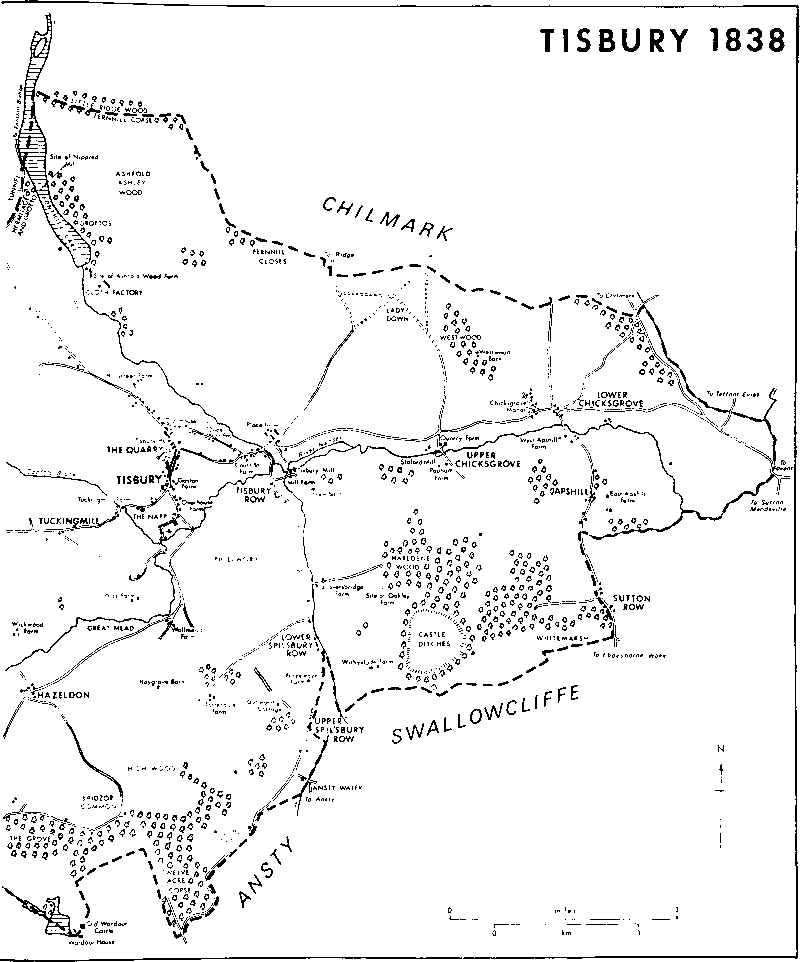
References to the abbot of Tisbury suggest that there was an abbey on what is now the site of the village in the 8th century, (fn. 3) and the origin of Tisbury parish may be as the estate of such an abbey. In the 10th century the abbey of Shaftesbury (Dors.) held an estate called Tisbury (fn. 4) which may have been Tisbury abbey's, and, apparently with three subtractions and one addition, that estate became the parish. In the 10th and 11th centuries the Tisbury estate may have included what became the parishes of Berwick St. Leonard, Chicklade, and Sedgehill. (fn. 5) The Tisbury portion of it was defined in the mid 11th century. In many places the boundaries seem to have been approximate to the later boundaries of the parish: they clearly included West Hatch and Oakley, separate estates of the abbey in the early 12th century, and, since they referred to Whitemarsh to the south-west, may have included the land later Sedgehill's, (fn. 6) joined to Tisbury's by a narrow corridor of low-lying land. They apparently excluded Berwick St. Leonard and Chicklade, the lands of which were detached from Tisbury's. (fn. 7) By c. 1130 Berwick St. Leonard, Sedgehill, and apparently Chicklade had been separated from the abbey's Tisbury estate, (fn. 8) and all three had been by then, or were later, separated from Tisbury parish. Wilton abbey's estate called Wardour was almost certainly not part of the land defined in the mid 11th century, (fn. 9) and Wardour is unlikely to have been one of the places whose inhabitants, in the early 12th century, paid tithes to Tisbury church and were buried at Tisbury. (fn. 10) Most of that estate, from the 15th century called the castle, manor, and park of Wardour, (fn. 11) was in Donhead St. Andrew parish in the early 18th century. (fn. 12) The boundary between Tisbury and Donhead St. Andrew was marked on maps of 1768–9, (fn. 13) when it was on its present course bisecting the old Wardour castle. Whether the boundary was drawn through the castle, which was built c. 1393. (fn. 14) or the castle built on the boundary is obscure. The castle was said to be in Donhead St. Andrew in 1597. (fn. 15) and the modern boundary was possibly drawn later. The owners of the castle, manor, and park of Wardour were lessees of the great tithes of Tisbury for nearly a century from 1576, (fn. 16) and perhaps exaggerated how much of the estate was in Tisbury: in the early 18th century the owner disputed what tithes should be paid from it to the rector of Donhead St. Andrew. (fn. 17) The boundary may have been drawn through the castle in the 17th century as part of a compromise with an earlier rector. In the early 19th century Tisbury parish, c. 7,509 a. (c. 3,036 ha.), was the land defined in the mid 11th century, excluding Sedgehill but including part of Wardour manor, (fn. 18) and, with small additions, that remained the ecclesiastical parish until 1975. (fn. 19) Within that parish detached parts of Ansty and Chilmark parishes were islands, 8 a. at Lower Chicksgrove and 5 a. at Upper Chicksgrove respectively. (fn. 20) In 1835 Tisbury parish was trisected to create three poorlaw parishes, East Tisbury, c. 2,705 a., West Tisbury, 1,134 ha. (2,803 a.), and Wardour, c. 2,003 a., by an inclosure award under an Act of 1834. (fn. 21) In 1885 the detached parts of Ansty and Chilmark at Lower Chicksgrove and Upper Chicksgrove were transferred to East Tisbury parish, and another detached part of Ansty, 12 a. SSE. of Tisbury village, was transferred to Wardour parish. East Tisbury and Wardour were united in 1927 (fn. 22) as Tisbury civil parish, 1,916 ha. (4,733 a.). In 1986 part of Tisbury parish, Apshill and Lower Chicksgrove, was transferred to Sutton Mandeville; and small parts of West Tisbury parish were transferred to East Knoyle and Tisbury. (fn. 23) This article deals with Tisbury parish as it was until 1835, which was the same area as the ecclesiastical parish as it was until 1975 without the additions of 1885.
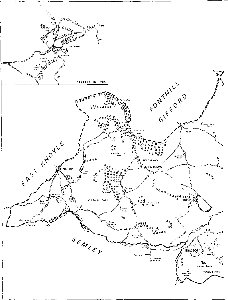
Tisbury parish was roughly rhomboid, 10.5 km. east—west and 6 km. north—south. Streams are the boundaries in the east with Teffont Evias and Sutton Mandeville, in the south-east with Swallowcliffe, and in the south-west with Semley; a ridge is the boundary with Fonthill Bishop in the north; valleys in which streams sometimes flow are the boundaries with Sutton Mandeville in the east and Donhead St. Andrew in the south; an ancient track is a boundary with Swallowcliffe and Ansty, and roads mark boundaries with Sutton Mandeville and Fonthill Gifford. All those boundaries have clearly survived from the mid nth century. (fn. 24) In the north-west, the boundary with East Knoyle runs straight across the contours and that with Fonthill Gifford follows the contours round Beacon Hill. Another part of the boundary with Fonthill Gifford, marked by a stream, was obscured when Fonthill lake was made and later enlarged. (fn. 25) Tisbury village is in the centre of the parish. The other principal villages and hamlets, Lower Chicksgrove, Upper Chicksgrove, East Hatch, West Hatch, Hazeldon, and Bridzor, were also on riverside sites. There have long been small settlements and farmsteads in all parts of the parish, however, and Newtown developed as a small village on high ground in the 19th century. (fn. 26) When the parish was trisected in 1835 half Tisbury village, Upper Chicksgrove, and Lower Chicksgrove were assigned to East Tisbury parish, East Hatch, West Hatch, and Newtown to West Tisbury, and half Tisbury village, Bridzor, and Hazeldon to Wardour. West Tisbury parish was marked off from East Tisbury and Wardour by streams. The boundary between East Tisbury and Wardour followed Vicarage Road, High Street, Cuff's Lane, and Court Street through Tisbury village and the Nadder east of it. (fn. 27)
All Tisbury parish drains to the Nadder which flows northwards and eastwards across it and marks the boundaries with Semley and Sutton Mandeville. The principal tributaries to enter it in the parish are from the west the Sem which marks more of the boundary with Semley, from the north-west Oddford brook which divided East Tisbury and West Tisbury, from the north the stream flowing through Fonthill lake and the stream dividing Tisbury and Teffont Evias, and from the south the stream flowing from Ansty which divided Tisbury and Swallowcliffe. That western end of the Nadder valley is called the Vale of Wardour, and is distinguished by outcrops of oolites. In Tisbury parish outcrops of Portland and Purbeck rocks form the high ground north and south of the Nadder and, especially those of Upper Portland limestone which have been much quarried for building stone, are extensive. Outcrops of Lower Greensand, Gault, and Upper Greensand form even higher ground north of the northern and south of the southern oolites. North of the Nadder the ground is highest in the west, 214 m. west of Newtown and over 198 m. in the north-west corner of the parish; further east it reaches 168 m. on the boundary with Fonthill Bishop, 159 m. north of Tisbury village, and 157 m. on Lady Down. South of the Nadder the ground is highest in the east: 193 m. is reached at Castle Ditches, over 183 m. north of the old Wardour castle, and 130 m. near the house called Wardour Castle. The relief of all the high ground is broken. Flatter land is in the west where Kimmeridge Clay outcrops: the land slopes gently from 137 m. west of Beacon Hill to below 107 m. beside the Sem. The clay has been exposed by the Sem and the Nadder as far east as Tisbury village. The Sem and the Nadder and its tributaries have deposited narrow bands of alluvium in the parish: where the Nadder forms the parish boundary at its lowest point, below 80 m., the band of alluvium in Tisbury parish is 250 m. wide. (fn. 28)
Nearly all the parish is suitable for arable and pasture and nearly all can support woodland: there are meadows beside the streams in all parts of it. There were open fields and common pastures in most parts. They were small, unlike those in parishes where there is extensive chalk downland, possibly because the relief is broken, the land was settled early, and many settlements in the parish had their own fields. The arable had been inclosed by c. 1500 and nearly all the pasture by c. 1600. (fn. 29) The land south of the Nadder was within the outer bounds of Cranborne Chase and possibly subject to some forest laws in the late 12th century and the 13th. (fn. 30) In the later Middle Ages and in the 18th century much land was imparked. The lord of West Hatch manor apparently made a park in the early 1280s, and the king gave him four bucks and eight does to stock his park at West Hatch in 1285; (fn. 31) in the 14th century there was a park west of Tisbury village called Roughcombe which was enlarged in the 1370s; (fn. 32) and land around Wardour castle had been imparked by the early 15th century. (fn. 33) Pythouse was enclosed in a park, (fn. 34) possibly in the earlier 18th century. (fn. 35) In the late 18th century land was imparked and the landscape altered at the north end of the parish around Fonthill House in Fonthill Gifford (fn. 36) and at the south end around Wardour Castle, (fn. 37) and the wall around Fonthill Abbey in Fonthill Gifford enclosed part of Tisbury parish, which was planted with trees. The park of Fonthill House was extended eastwards in the 19th century. (fn. 38)
Unusually for so large a parish no main road crossed Tisbury, and no road in it was turnpiked. (fn. 39) Minor roads and lanes serve all parts of the parish. Tisbury village in the centre is a focus for those from Hindon, Chilmark, Fovant and Lower Chicksgrove, Swallowcliffe, Ansty, Semley, and East Knoyle. The only road to cross the parish is the Chilmark-Fovant road in the east. Until the 19th century a second road led south from Chilmark through Lower Chicksgrove and Sutton Row in Sutton Mandeville over the downs towards Ebbesborne Wake. (fn. 40) Where it forms the parish boundary at Sutton Row the road was mentioned in the mid 11th century. The road which leads from Fonthill Bishop towards Semley was also a boundary in the mid 11th century. (fn. 41) It was apparently the road obstructed in the 1370s when Roughcombe park or a park in Fonthill Gifford parish was enlarged. It may have been diverted then, but seems likely to have remained on its earlier course. (fn. 42) It crosses the Hindon-Tisbury road, which may have been on its present course in the mid 11th century, (fn. 43) and at Newtown crosses Hatch Lane, so called in 1773. (fn. 44) Hatch Lane links Hindon and East Hatch, and from it a road diverges over the highest land in the parish to Donhead St. Andrew. The Semley-Tisbury road was diverted northwards at Bridzor c. 1820. (fn. 45) Between 1773 and c. 1807 a new part of the East Knoyle to Tisbury road, which may earlier have been blocked by Pythouse park, was made from Kinghay: where it joined a circuitous Semley-Tisbury road on the south side of the park several roads were slightly altered. (fn. 46) Between 1838 and 1886 the road from West Hatch (fn. 47) to Kinghay was diverted away from Dennis's Farm, later Park House; and in the later 19th century new roads were built in Tisbury village. (fn. 48) In 1985, however, the arrangement of roads in the parish was nearly as it was in 1773 (fn. 49) and almost certainly long before.
The Salisbury & Yeovil Railway opened a railway across the parish in 1859. The line linked Salisbury and Gillingham (Dors.), was connected to the L. & S.W.R.'s line from Salisbury to London, and was extended to Exeter in 1860. (fn. 50) It closely followed the Nadder and the Sem. A station built at the south edge of Tisbury village, and opened in 1859, attracted commerce and industry southwards towards it. (fn. 51) The line had been doubled by 1870: (fn. 52) the part across the parish was singled in 1967. (fn. 53)
Tisbury parish is not rich in archaeological discoveries. Three upright stones of what may have been a henge monument were removed from a site near Place Farm c. 1792: the name of the field from which they were taken, Lost Stone field, (fn. 54) is, however, a corruption of the earlier Low Stone field. An Iron-Age hill fort was called Oakley castle in the 14th century and later, its ditches and banks, enclosing 25 a., were called Castle ditches in the 16th century, and the whole earthwork afterwards took the name Castle Ditches. (fn. 55) Roman remains and earthworks have been found north of Tisbury village, older artifacts in other parts of the parish. There is a bowl barrow north of Place Farm. (fn. 56)
Tisbury may be named in the Burghal Hidage, a list of the fortresses prepared for defence by Alfred against the Danes. (fn. 57) The form of the name, 'Cissanbyrig', in a copy of the list, and doubts, perhaps unfounded, that a suitable site for such a fort could be in or near Tisbury village, have led to the suggestion that Alfred prepared to defend not Tisbury but Chisbury in Little Bedwyn. The placing of the name between Wilton and Shaftesbury in the Burghal Hidage, (fn. 58) and the fact that like others in the list Tisbury may already have been a notable place, make it slightly more likely that the fort was near Tisbury than at Chisbury: probably 700 hides were assigned for the defence of the fort which may therefore have incorporated 962½ yd. of wall. (fn. 59)
There were riverside settlements throughout the parish in the early Middle Ages. (fn. 60) Tisbury, in the centre of the parish where the Nadder is joined by three other streams, was the largest of seven villages or hamlets beside the Nadder. East of it were Chicksgrove, later called Lower Chicksgrove, and Stoford, later called Upper Chicksgrove. (fn. 61) West of it were Wick and East Hatch north of the Nadder, and Hazeldon and Bridzor south. Also beside the Nadder, Wallmead was a farmstead in the 12th century. Hamlets called Nippred and Fernhill in the north seem likely to have stood beside the northern tributary of the Nadder, with Fonthill Gifford and Fonthill Bishop apparently making a line of four settlements in less than 2 km. Oakley was a settlement beside the southern tributary of the Nadder, (fn. 62) and in the 14th century Roughcombe may have been a hamlet beside Oddford brook. (fn. 63) In the nth century Wardour was probably beside the stream then intermittent, almost certainly a stream flowing westwards to the Nadder. (fn. 64) In the west part of the parish West Hatch village was beside the Sem, and Linley and Billhay, (fn. 65) and later Old Street were farmsteads or hamlets beside its tributaries. The only 12th-century settlements to have been on higher ground were apparently Apshill and Totterdale. (fn. 66) That pattern of settlement in the parish is still discernible, but several of the hamlets or farmsteads beside the streams have shrunk or disappeared. From the 18th century to the 20th most new settlement has been on higher ground: west of Tisbury village Newtown and Tuckingmill have grown into small villages, there has been settlement around Pythouse, and new farmsteads have been built in most parts of the parish, (fn. 67)
Tisbury was a wealthy and populous parish, as might be expected because it was so large and widely settled. The combined assessment of Tisbury and 'Hatch' in 1334 was apparently the fifth highest in Wiltshire for a single parish. (fn. 68) To judge from a court of January 1349 in which the deaths of c. 75 customary tenants of Tisbury manor, a very high proportion, were recorded, (fn. 69) the Black Death was very severe in the parish. Despite that, the number of poll-tax payers, 433, shows Tisbury to have remained among the most populous parishes in the county in 1377. (fn. 70) The parish was again highly assessed for taxation in the 16th century, (fn. 71) but by then Tisbury, in which there was little industry and no market or fair, was not among the most highly rated in Wiltshire. The population of the parish rose from 1,961 to 2,259 in the period 1801–31. (fn. 72) From 1841, when it was 2,419, to 1981, when it was 2,254, the population of the old Tisbury parish has been remarkably stable. It was highest, 2,448, in 1881, and lowest, 2,022, in 1931. Although stable, the population moved within the parish. Of the three parishes created in 1835 East Tisbury with 979 inhabitants in 1841 was the most populous. Its population fell from 940 in 1861 to 862 in 1871 mainly because people moved from East Tisbury to West Tisbury. In 1885 East Tisbury's population, 894 in 1881, was increased by a total of 9 transferred from Ansty and Chilmark. It fell from 869 in 1891 to 769 in 1901, and from 828 in 1911 to 729 in 1921. Wardour parish had 706 inhabitants in 1841. The number fell from 710 in 1861 to 679 in 1871 because the union workhouse in the parish was closed. (fn. 73) Between 1871 and 1891 new buildings were erected in High Street, (fn. 74) 9 people were transferred from Ansty, and the population increased to 861. It had declined to 780 by 1921. West Tisbury parish had 734 inhabitants in 1841, 653 in 1861. The population had risen to 855 by 1871 because people moved thither from East Tisbury and because the new workhouse was built in the parish. It had declined to 712 by 1891 when West Tisbury was the least populous of the three parishes. It remained so in 1921 when it had 691 inhabitants. The decline in West Tisbury's population continued until 1971 when it was 429, and, mainly because council houses were built in Tisbury village, the population of the new Tisbury parish rose from 1,387 in 1931 to 1,870 in 1971. Between 1971 and 1981 Tisbury's population fell to 1,728 and, mainly because of new housing on the edge of Tisbury village, (fn. 75) West Tisbury's rose from 429 to 526. The new housing of the 1970s was transferred to Tisbury parish in 1986. (fn. 76)
No site within the present Tisbury village is known to have been that of an early abbey. Tisbury village was mentioned in the late 9th century. (fn. 77) Tisbury church stood on its present site on the north bank of the Nadder from the late 12th century or earlier, (fn. 78) and until the later 19th century marked the south end of the village. (fn. 79) Tisbury manor and, from the late 14th century, Tisbury church belonged to Shaftesbury abbey, (fn. 80) and, on the east bank of the northern tributary of the Nadder, the abbey erected large and elaborate buildings for residence, worship, agriculture, and collecting tithes. The buildings are in many ways similar to the abbey's at Bradford on Avon, (fn. 81) and like them were slightly apart from the village. They were called the 'manor place' in 1579, (fn. 82) Place Farm from 1717 (fn. 83) or earlier. The house was for the abbess to live in and even when the abbey's demesne was leased the farmer lived in a house near a bridge, presumably west of Place Farm. In the later 15th century the buildings incorporated two chapels, one adjoining the abbess's chamber. (fn. 84) In 1541 walls enclosed the house and its chapel, a building with four upper and four lower rooms, an outer gatehouse and a house built into the walls beside it, two larder houses, stables, houses for oxen, hay, and charcoal, and a fishpond. The great barn and three fishponds were outside the walls. In the later 16th century Place Farm was apparently not leased and may have been little used, (fn. 85) and by c. 1640 it had been divided among three farmers. (fn. 86) It was again a single farmstead in the 18th century. (fn. 87) The medieval buildings to survive are an inner gatehouse and the outer gatehouse, the abbess's house, and the barn. The outer gatehouse and the house (fn. 88) were built in the earlier 14th century, the inner gatehouse and the barn in the 15th. Medieval walling may also survive in farm buildings between the house and the barn. At its centre the house had an open hall entered by opposing two-centred doorways at its north end: north of that was an open kitchen with, in the north wall, a large fireplace which retains its original stone chimney louvres. A room behind the fireplace is now entered through it. South of the hall the house was two-storeyed: it has a roof with cusped arch braces above the upper room which was presumably a solar or great chamber. On the east side of the main range a short wing appears to be 17th-century, but the thinness of the wall separating them suggests that the hall and wing are contemporary. The hall and kitchen were floored over and the whole house was refenestrated in the 15th century or early 16th, and, presumably then, a fireplace was built against the north wall of the hall and a new west entrance made at its south end. The house was much restored in the 19th century. Its south-west corner is joined to the inner gatehouse by a wall which supports a first-floor passage. The gatehouse consists of a narrow passage and a lodge on the ground floor and a room on the first, and formerly extended further west. The outer gatehouse was reconstructed and extended in the 15th and 16th centuries to form a two-storeyed range with large and small entrances from the road. The centre of that range is all that survives. The stone barn, 61 m. by over 9 m., has original central transeptal entrances and a roof of crucks with two tiers of collars, the lower of which are arch-braced. (fn. 89) Almost certainly from the 14th century or earlier a mill stood on the Nadder south of Place Farm. (fn. 90) The surviving mill is mostly 18th-century, and a small, apparently 18th century, farmhouse is nearby. A group of six cottages stood south of Place Farm in 1769. (fn. 91) Two south of the Tisbury-Fovant road survive. Two pairs of cottages, which also survive, had replaced the others by 1838. (fn. 92)
In the early 12th century Tisbury may have been a village of many homesteads from which small holdings of land were worked. (fn. 93) A village street referred to in the mid 15th century (fn. 94) was presumably the north part of what is now High Street. North-west of High Street, Hillstreet Farm, so called in 1353, (fn. 95) was linked to High Street by the Hindon-Tisbury road, called North Street in 1444 (fn. 96) and later Hindon Way (fn. 97) and Hindon Lane: there was apparently settlement along the road in the 15th century. (fn. 98) Two other streets meet at the junction of Hindon Lane and High Street, a junction later called the Cross. (fn. 99) Court Street, leading to Shaftesbury abbey's 'curia', Place Farm, was so called in 1517: (fn. 100) the western part was later called Farrier's or Cuff's Lane. (fn. 101) Duck Street was so called in 1736. (fn. 102) High Street bifurcated at what was its south end in 1769 and settlement extended along both branches. (fn. 103) The western was later called Vicarage Road. The eastern curved westwards to run north of the church, where it was later called Church Street: its northern part is now called the Causeway. In the 14th century a hamlet called Walton was near Tisbury, (fn. 104) presumably in the same area as Wick (fn. 105) and Wallmead Farm: Walton Street, so called in 1474, (fn. 106) may be an earlier name of Church Street. In 1769 both sides of High Street were built up, and there was settlement in Hindon Lane as far as Hillstreet Farm and in Cuff's Lane, Court Street, Duck Street, Vicarage Road, the Causeway, and Church Street. (fn. 107) Among the buildings which stood then and survived in 1985 were several copyhold farmhouses of Tisbury manor. (fn. 108) The predominant building material in them all is local stone. In High Street, Gaston Manor, the largest, has a west range of late-medieval origin. That range was much altered, notably in the earlier 17th century when its south end was apparently rebuilt, new fireplaces, including one re-using a carved stone bressummer of c. 1500, were inserted, and a pair of east wings was added. The inside of the house was greatly altered in the 19th century. Also in High Street, the Old House appears to be 17th-century. Court Street Farm is apparently 17th-century and a house in Duck Street is 17th-century or older. Two small 17th century farmhouses survive in Vicarage Road in an area called the Napp in 1773, (fn. 109) and Overhouse in the Causeway and a farmhouse at the east end of Church Street are also 17th-century. Other 17th-century buildings to survive in what were the village streets in 1773 include the Cross inn, which may be older, part of the Boot inn in High Street, a house and several cottages in Hindon Lane, stone and thatched cottages in Cuff's Lane and Duck Street, a pair of cottages in the Causeway, which may be later, and some five cottages which, with gables and dormers, form a notable group in Church Street. The 18th century buildings in High Street include several cottages at the north end, some of which may be older, two nonconformist chapels, a mid 18th century house called the Elms with a 19th-century wing, and several other houses. There was a church house in Tisbury in 1598, (fn. 110) possibly west of the church on the site of the later church house, a stone structure which was given a new upper storey of red brick in 1887. (fn. 111) The parish workhouse was northeast of the church. (fn. 112)
In the late 18th century and earlier 19th there was much new building in the north part of the village. On the west side of Hindon Lane, Tisbury House is a large house built shortly before 1838; on the east side Hillstreet Farm was rebuilt in the early 19th century as a three-storeyed house which possibly incorporates part of an earlier house in its north, service, end. West of High Street at its north end cottages were built between 1773 and 1838 in an area called the Quarry, (fn. 113) and a nonconformist chapel was built there soon afterwards. (fn. 114) The cottages, small and not of high quality, include two later terraces of four, one called Temperance Row. Weaveland Road bounds them to the south and gives them access to High Street.
[Tisbury in 1838: eastern half, with streets layout of 1985 (inset)]
[Tisbury in 1838: western half]
Tisbury village was changed much between the opening of the railway in 1859 and the First World War, and in that period took on the appearance of a small town. The workhouse which was closed in 1868 was converted into a brewery, and a large new brewery was later built on the site. In 1869 the owner of the brewery, Archibald Beckett, extended High Street southwards by building a new street from where Vicarage Road and the Causeway left the old. (fn. 115) The new street, west of the Causeway, the south end of which was closed, linked the brewery with the old part of High Street, and, by a road which had long diverged from the line of the Causeway and Church Street, directly with the station. The Benett Arms was built in 1875 (fn. 116) at the north end of the new street which by c. 1900 had been lined by houses, (fn. 117) some terraced and incorporating shops, bearing marked architectural similarities. West of the new street Paradise Row, a terrace of 10 cottages of stone with red-brick dressings, was built c. 1875. (fn. 118) Near the station the Arundell Arms was built between 1859 and 1867, (fn. 119) and the South Western Hotel in 1884, (fn. 120) and in the late 19th century and early 20th buildings were erected for trade and industry. (fn. 121) South-west of the church a new workhouse was opened in 1868 (fn. 122) and Union Road was made to it from Church Street. In 1881 New Road, later called the Avenue, was built to link the junction of Church Street and High Street, a junction later called the Square, and the junction of Cuff's Lane, Court Street, and Duck Street; and soon afterwards Park Road was made parallel to it to link the old part of High Street and Cuff's Lane. (fn. 123) From 1887 petty sessions were held at Tisbury: (fn. 124) a police station and a sessions hall were built in New Road in 1889. (fn. 125) New schools were built in Church Street in the 1860s and in High Street in 1873, (fn. 126) the Victoria Hall was built in High Street in 1887, (fn. 127) and a reading room and library beside the school in High Street was opened in 1913. (fn. 128) Two new churches were built in High Street c. 1900. (fn. 129) Sewage works were built in 1908 and waterworks in 1911, (fn. 130) and in 1914 a fire brigade was formed with a station adjacent to the Victoria Hall. (fn. 131)
Several substantial private houses were built between 1838 and 1886. They include a villa called Tisbury Lodge, Canonbury House, in an Italianate style, Italian Cottage, and the Gables, all in Hindon Lane, Arundell House east of High Street at its north end, Albany House at its south end near the new brewery, the Vicarage, and a house in Weaveland Road. (fn. 132) The Gables was lived in by J. L. Kipling, Rudyard Kipling's father. (fn. 133) Belle Vue in Union Road was built in the early 20th century. (fn. 134) Weaveland Farm was built south-west of Hindon Lane between 1838 and 1886. (fn. 135) Later 19th- and 20th-century cottages survive in most parts of the village.
Many new houses were built in Tisbury village after 1918, most after 1945 and nearly all on new sites. Between 1918 and 1939 a total of 36 council houses was built in Weaveland Road, in Doctor's Place off Weaveland Road, and in Hindon Lane. A total of 56 council houses, the Churchill estate, was built between Weaveland Road and Vicarage Road between 1949 and 1953, and five bungalows for old people were built there in 1964. The north side of New Road (the Avenue) and Queen's Road north of it were the sites of 95 council houses, including 44 bungalows for old people, built between 1958 and the early 1970s. In Cuff's Lane a pair of council houses was built, apparently in the 1950s, and six bungalows for old people near those in Queen's Road were built in 1964. A house and 24 council homes for old people were built in the early 1970s as a square, called Nadder Close, on the south side of the Avenue; six more council bungalows for old people were built in Court Street in the mid 1970s; and in the late 1970s a total of 42 council houses and bungalows was built in St. John's Close north of Union Road. New private houses were built in Park Road, most of them apparently c. 1930, 11 private houses were built in Oddford Vale off Union Road after 1945, and there has been infilling in most parts of the village. In the early 1980s an estate of 56 private houses was built south of Union Road on the site of the workhouse of 1868, and eight private houses were built at the south end of High Street. (fn. 136) The county council opened a health clinic in the village in 1930, (fn. 137) and a new fire station was built in Park Road in 1939: a new building to house both a police station and a fire station was erected in the Avenue in 1974. (fn. 138) A new sewage works was built east of the village in 1958. (fn. 139) In 1985 Tisbury retained the appearance of a small town with c. 30 shops and two garages in High Street. Most of it was designated a conservation area in 1974. (fn. 140)
In 1650 inhabitants of Tisbury parish petitioned for an alehouse near the church to be licensed, referring to parishioners who needed refreshment after travelling several miles to attend meetings and do parish business. (fn. 141) That petition may be the origin of the Crown in Church Street, but of the inns in Tisbury in 1985 only the Boot, where John Benett's cause of political independence was promoted in the early 19th century, (fn. 142) bore its present name in 1757. (fn. 143) The Crown was so called in 1859. (fn. 144) The Cross in was open in 1927. Of the other five inns in Tisbury village then, (fn. 145) all but the Arundell Arms were open in 1985.
The south end of High Street is linked to the station south of the Nadder by a three-arched bridge possibly of the early 19th century: the bridge there was called Pool bridge in 1773. (fn. 146) In the east part of the village the bridge over the Nadder, possibly the bridge called Berry bridge in 1520 and later, was rebuilt in 1949, that over the northern tributary, possibly the bridge called Otter bridge in 1520, was rebuilt in 1912. (fn. 147)
South of Tisbury village, in an area bounded east by Haredene Wood and Castle Ditches and west by the lands of Hazeldon and Bridzor, there was settlement in the early 12th century. At Oakley there was then a manor and hamlet, and there were farmsteads or hamlets called Totterdale and Wallmead. (fn. 148) The buildings of Oakley almost certainly stood near the road from Place Farm to Ansty where a farmstead was called Shaversbridge in 1769 and Oakley in 1773. (fn. 149) Presumably from 1458, when several holdings of Oakley land were merged, (fn. 150) Oakley Farm stood east of the road near Haredene Wood: its farmhouse had been demolished by 1769, and the farm buildings were demolished between 1769 and 1773. (fn. 151) Spilsbury, Withyslade, (fn. 152) Dunworth, (fn. 153) and Furzeleaze (fn. 154) were all place names in the Middle Ages and the 16th century, but there is no evidence of buildings then on the sites which later bore those names. Farmsteads called Withyslade (fn. 155) and Squalls (fn. 156) were built in the early 17th century. In 1769 there were three groups of cottages beside the road from Place Farm to Ansty, Tisbury Row near the Nadder and Lower Spilsbury Row and Upper Spilsbury Row further south. (fn. 157) All three survive and each has thatched cottages of the 17th or 18th century and a few later buildings. In 1769 New Barn, to which a farmyard was added between 1838 and 1886, was south-east of Tisbury Mill, there was a farmyard called Highgrove or Haygrove south of Wallmead Farm, and a house belonging to 'Tisbury club' was on the site of what became Spilsbury Farm in the mid 19th century. Between 1811 and 1838 Furzeleaze Farm, where additional buildings were erected in the 20th century, was built west of the road from Place Farm to Ansty, and Dunworth Cottage was built beside the Tisbury—Ansty road. (fn. 158) Eight council houses were built near Ansty Water, apparently in the 1950s. Only a barn stood on the site of Shaversbridge Farm in 1838: two cottages were built near it in the 19th century. (fn. 159) Wallmead Farm and a cottage near it were largely rebuilt in the 19th century: in 1985 the extensive farm buildings were mostly 19thand 20th-century. A 19th-century cottage was all that survived of Haygrove Farm. Totterdale Farm consists of a main north—south range of the early 17th century and a short rear wing surviving from an earlier house: among mostly 19th- and 20th-century farm buildings is a large granary on staddle stones. A new Withyslade Farm was built in the 19th century: in 1985 extensive 20th-century farm buildings stood near it. Squalls Farm is a small 17th-century timber-framed and thatched house, possibly that built in the early 17th century: between 1971 and 1973 it was enlarged and altered to include outbuildings, and a large stable court was built, all for Mr. R. G. Saffron. (fn. 160) East of Squalls Farm a pair of cottages may also be 17th-century.
Settlement in the north part of Tisbury parish in the Middle Ages was in four hamlets or farmsteads, Nippred, Ashfold, Fernhill, and Roughcombe, the exact sites of which are not known. Nippred (fn. 161) was near Fonthill Gifford, (fn. 162) the church of which was then near the northern tributary of the Nadder, (fn. 163) and the names of buildings and fields in the 18th century suggest that Nippred was on the west bank of the stream. A mill and a house stood on such a site in the later 18th century: (fn. 164) both were removed when Fonthill lake was enlarged then. A new house was built further south: (fn. 165) it was replaced by a cottage in the mid 19th century. Ashfold may have been a small settlement in the 12th century: (fn. 166) the well built house standing beside Ashfold wood in 1427 (fn. 167) may have been on the same site. In the 16th century there was a farm called Ashfold Wood and that house or a successor was presumably its farmhouse. (fn. 168) Ashfold, later Ashley, wood was west of the tributary, (fn. 169) an area where no building stood in 1773. (fn. 170) A small farmstead which in 1769 stood east of the stream, a little south of what became the south end of the lake, (fn. 171) may have stood near the site of Ashfold. In the early 19th century it was replaced by a house, cottages, and a cloth factory built on and around its site at what was then the south end of the lake: those buildings had been demolished by 1886. (fn. 172) The mill race of the factory and a few small buildings survive on the site, and the stone-faced earth dam was being reinforced in 1985. Nearby Ashley Wood Farm was built in 1861. (fn. 173) A cottage was built in the new Ashley Wood between 1838 and 1886 (fn. 174) and was restored in the later 20th century. Fernhill may also have stood near Fonthill Gifford since sometimes its lands were said to be in Fonthill Gifford (fn. 175) and sometimes in Tisbury. (fn. 176) In 1559 tithes were paid to the vicar of Tisbury in respect of some of or all the lands. (fn. 177) No building survives to indicate the sites of the tenements of Fernhill manor, which had possibly been demolished by 1425, (fn. 178) but 19th-century field names suggest that they were north of Nippred on the east bank of the stream. (fn. 179) Roughcombe was presumably a small settlement in the late 13th century when a surname was derived from it, (fn. 180) a manor house was called Roughcombe in the early 14th century, (fn. 181) and Roughcombe manor apparently included several tenements and a mill in the later 14th century. (fn. 182) By the 16th century all those buildings may have been abandoned. (fn. 183) The name Roughlawn, in use in 1716 (fn. 184) and applied to an area north of Newtown, (fn. 185) suggests that the land of Roughcombe may have been divided among the farms north-east of Newtown with 'Lawn' in their names: (fn. 186) if so, in the 14th century Roughcombe may have stood beside Oddford brook. Lower Lawn Farm and Upper Lawn Farm were standing in 1773. (fn. 187) The farmhouse of Lower Lawn was replaced c. 1866, (fn. 188) when new farm buildings were erected: some of the buildings were demolished in the later 20th century. A cottage and a farm building, both 19th-century, and a small house of 1961–2 (fn. 189) are on the site of Upper Lawn. Higher Lawn Farm, incorporating a large farmhouse, was built between Lower Lawn Farm and Upper Lawn Farm in 1869: (fn. 190) large farm buildings have been added in the later 20th century. Land in the north-west corner of the parish was called Ruddlemoor in 1419. (fn. 191) A farmstead stood there in the 18th century (fn. 192) and almost certainly earlier: 19th-century farm buildings and a pair of 20th-century cottages remain on the site. Eight cottages on land enclosed by the wall of Fonthill Abbey and demolished in the 1790s were on the east side of Hatch Lane near Beacon Hill. (fn. 193) Several grottos were built beside the lake in the park of Fonthill House in the late 18th century, and a lodge was built in 1860 (fn. 194) for the then new Fonthill Abbey. (fn. 195) There has also been settlement in the north part of the parish on the west side of the Hindon-Tisbury road. Two buildings stood there in 1773, one of which, a 17th-century thatched cottage, survives. Several cottages built further south between 1773 and 1838 (fn. 196) and Prospect House, a large villa built between 1838 and 1886, (fn. 197) also survive. A rustic lodge on the east side of the road at the north end replaced an older building, (fn. 198) apparently in the late 19th century. There has been infilling on the west side in the 20th century and in 1985 settlement on that side, including 14 detached bungalows in Beckford Close built soon after 1970, (fn. 199) was almost continuous from Fonthill Gifford church to Tisbury village.
Settlement in the west part of the parish in the Middle Ages was at West Hatch and East Hatch, and in several hamlets or farmsteads. West Hatch manor possibly included c. 15 small farmsteads in the early 12th century. (fn. 200) Their sites are obscure, but several may have been along the road which leaves the Hindon to Donhead St. Andrew road to the west and is parallel to the Sem. West Hatch was called a hamlet in 1341, (fn. 201) and in the later 16th century apparently consisted of several farmsteads not very closely grouped. (fn. 202) Hatch House was built on high ground north of the road. In 1773 there was no village centre: farmsteads were scattered along the road and beside the Hindon to Donhead St. Andrew road north and south of the junction, an area then called West Hatch. (fn. 203) The only survivors from 1773 are Park House, formerly Dennis's Farm, a 17th- or 18th-century farmhouse which was aggrandized in the early 20th century, and a small stone farmhouse of similar date east of Hatch House. Houses west of Dennis's Farm and beside the Sem at Savage bridge, perhaps formerly farmsteads, were demolished between 1838 and 1886. On the sites of other houses Poulden's Farm is an early 19th-century house with extensive 20th-century farm buildings, there are a pair of 19th-century cottages, a small 19th-century house with outbuildings, and 20th-century farm buildings near the junction, and cottages are near the farmhouse east of Hatch House. (fn. 204) East of the Hindon to Donhead St. Andrew road a farmyard was built before 1773. (fn. 205) In 1985 its ruins and a cottage, built between 1838 and 1886, (fn. 206) occupied the site. Red House was built east of Poulden's Farm in the early 20th century, (fn. 207) and farm buildings were erected south of Hatch House in the later 20th.
In the 16th and 17th centuries Pythouse was said to be in East Hatch: (fn. 208) in 1725 it was a mansion house, soon after demolished, with a terraced garden north of it, on a site now unknown. A house with four rooms to a floor built a mile from it in or shortly after 1725 (fn. 209) was almost certainly the Pythouse built then on the site of, and incorporated in, the present Pythouse. In the early and late 19th century Pythouse was transformed and many buildings were erected near it. (fn. 210) Outside its park a farmstead called Pythouse Farm was built east of the house, mostly in the early 19th century. Its farmhouse, built between 1838 and 1886, survives; a house in vernacular style was built beside the Hindon to Donhead St. Andrew road in the late 19th century; and a pair of cottages was built in the early 20th. East Lodge was built near Pythouse Farm between 1838 and 1886. (fn. 211) West Lodge on the west side of the park was built in 1869, (fn. 212) north-west of it a pair of red-brick cottages was built in the 19th century on the foundations of an older building, and south-west of it is an avenue of Wellingtonias. South of the park a late 19th-century cricket pavilion (fn. 213) has been incorporated in the premises of a club for cricket, tennis, squash, and swimming.
Settlement at East Hatch was more concentrated than at West Hatch. In 1773 farmsteads and cottages stood beside a curving lane, the north-west and south-east ends of which had by then been linked by a straight road, and in a lane running south-westwards from it. (fn. 214) In the early 19th century there were c. 34 houses and cottages there. (fn. 215) The site of the medieval chapel in the village (fn. 216) is unknown. At the south-east end of the village an apparently 17th century cottage incorporates a 14th-century window: the cottage may have been the public house recorded in 1838 (fn. 217) and was the Benett Arms in the later 19th century. (fn. 218) Near it are two small houses apparently of the 18th century. At the north-west end Hatch Farm incorporates a 17th-century farmhouse, 19th-century farm buildings on older foundations, and large 20th-century farm buildings. A nonconformist chapel was built nearby. (fn. 219) South of Hatch Farm is a large early 18th-century farmhouse, and near that are two 18th-century cottages, one of them thatched. In the lane running south-westwards (fn. 220) an 18th-century cottage survives. In the 19th century and the 20th a few houses were built in both parts of the village, but more older buildings were demolished and the population almost certainly declined.
Wick was a settlement in the early 12th century near the site of the present Wick Farm. (fn. 221) It may have been a hamlet in the late 14th century (fn. 222) but was later a single farmstead: c. 1700 Wick Farm was rebuilt and a new farmstead, Wickwood, was built between Wick and East Hatch. Both farmhouses survive, Wick with farm buildings of the 19th and 20th centuries, Wickwood with a 19th-century barn which was converted into a house in the late 20th century.
Linley was a settlement south-west of Beacon Hill. (fn. 223) For most of the Middle Ages it may have consisted of no more than a single farmstead. Later, apparently from the 16th century, there were three farmsteads, (fn. 224) called Upper Linley, Middle Linley, and Lower Linley in the 18th century. (fn. 225) In 1838 there were two: the buildings called Upper Linley Farm when they were demolished between 1886 and 1900 (fn. 226) were possibly those of Middle Linley Farm. Cool's Farm, possibly the earlier Upper Linley Farm, consists of a 17th-century farmhouse and 19th-century farm buildings. A new Linley Farm, including a mill, was built north-west of Pythouse in the early 19th century (fn. 227) and more farm buildings were erected later in that century. Extensive farm buildings were added c. 1983; and in 1983 a large house, Linley Farm, incorporating materials from the old farm buildings, was built to his own designs for Mr. R. G. Saffron. (fn. 228) A pair of cottages was built south-west of Cool's Farm between 1886 and 1900. (fn. 229)
In the south-west corner of the parish four farmsteads have a long history. Billhay was so called in the 11th century (fn. 230) and was apparently a farmstead in the late 12th (fn. 231) and early 13th. (fn. 232) Its buildings were neglected in the mid 14th century and in 1360 were worth no more than their materials. (fn. 233) The farmstead may have been restored, or a new one built, in the late 14th century. (fn. 234) In 1985 Billhay Farm consisted of a mid 19th-century house in Tudor style and 19th- and 20th-century farm buildings. Priors or Priory Farm may have been a small farmstead from the early 13th century, (fn. 235) and was called Priors in 1590. In 1985 it was a house, possibly 18th-century, and 20th-century farm buildings. A farmstead was called Old Street from 1583 (fn. 236) or earlier: its buildings were replaced by a pair of cottages in the 19th century. Tokes Cottages is a possibly 18th-century building from which a small farm was worked in the 19th century. (fn. 237) Those four farmsteads are east and west of a lane, beside which common pasture remained in 1985, called Old Street lane in 1565, (fn. 238) later Tokes Lane. (fn. 239) At the north end of the lane a small settlement, partly in East Knoyle, was called Kinghay in 1773. (fn. 240) In 1985 Kinghay consisted, in West Tisbury, of a house, formerly a pair of 19th-century cottages, and a pair of cottages built in 1873, (fn. 241) and in East Knoyle of a 20th-century house.
A fulling mill stood on Oddford brook west of Tisbury village from the 1590s or earlier: (fn. 242) later a farmstead occupied the site where a new farmhouse, Tuckingmill Farm, was built apparently in the early 18th century. In 1769 there were buildings on both sides of the lane west of Tuckingmill Farm. (fn. 243) The rising ground west of them was called Tuckingmill Hill from c. 1640 (fn. 244) or earlier, and in 1773 a small, apparently 18th-century, farmhouse stood on it. (fn. 245) Of the buildings of 1773 only the farmhouses survive. Near Tuckingmill Farm a cottage which stood in 1838 (fn. 246) also survives, and another cottage and a nonconformist chapel (fn. 247) were built later in the 19th century. Between 1838 and 1886 c. 15 cottages were built on the higher ground. The settlement, called Tuckingmill in 1886, (fn. 248) expanded in the late 19th century when eight estate cottages were built, (fn. 249) and in the later 20th when a total of c. 12 houses and bungalows was built. Several cottages and houses were built beside the road west of Tuckingmill in the 19th and 20th centuries.
Between 1800 and 1823 William Beckford built eight cottages, called Castle Town, beside Hatch Lane at a crossroads south of Beacon Hill, (fn. 250) presumably to replace those enclosed by the wall of Fonthill Abbey. Extended and altered, six survive. A few buildings stood south and south-east of their site in 1773 (fn. 251) and 1838, (fn. 252) and c. 1807 the hamlet was called Newtown. (fn. 253) A school was built there in the mid 19th century and a church in the early 20th. (fn. 254) Two pairs of, and two terraces of four, estate cottages were built in the later 19th century: one pair is dated 1889 but all were apparently standing in 1886. (fn. 255) Two pairs of council houses were built in 1954. (fn. 256) and two private houses later. Of the c. 25 houses at Newtown in 1985 none appeared to have been built before 1800.
In the east part of the parish there were three settlements in the 12th century, Chicksgrove, Stoford, and Apshill. (fn. 257) Apparently in the 14th century, Stoford was described as 'by Tisbury' and 'in Tisbury', (fn. 258) and it was clearly the settlement later called Upper Chicksgrove where Stoford Mill in Chilmark was so called in the 18th century. (fn. 259) In the 14th century the settlement also seems to have been called Popham, (fn. 260) a name which survived in the 19th century. (fn. 261) Stoford was first called Upper Chicksgrove, and Chicksgrove first called Lower Chicksgrove, in the later 19th century. (fn. 262)
In the later 18th century most settlement at Lower Chicksgrove was along a north-south lane west of the crossing of the Tisbury-Fovant and Chilmark to Ebbesborne Wake roads where the farmsteads of what had been several large copyholds of Tisbury manor stood. (fn. 263) The largest to survive, Chicksgrove Manor, is reputed to be one of the farmsteads occupied by the Davies family, copyholders in the 16th, 17th, and 18th centuries, (fn. 264) and the birthplace of the lawyer, poet, and political writer Sir John Davies (d. 1626). (fn. 265) It stands on the east side of the lane at its junction with the road. The central section of its main east—west range is a late-medieval two-bayed open hall with central raised crucks and a screens passage, the timber walling of most of which survives. Late in the 16th century the hall was given an upper floor, a two-storeyed porch was built in front of the south doorway of the screens, and a parlour cross wing, which retains original panelling, was built at the east end. A north service wing was added at the west end in the 19th century. (fn. 266) Of some five farmhouses which stood beside the lane in 1769 (fn. 267) and 1838, (fn. 268) two 17th-century houses on the east side were derelict in 1985. At the north end in 1985 were a small 18th-century house and a 17th-century cottage which had been greatly extended in the later 20th century. There were also farm buildings of the 19th and 20th centuries and two 20th-century houses in the lane. East of the lane, there were a few buildings at the crossroads in 1769. (fn. 269) A cottage, possibly 18th-century, survives, but the others have been replaced by a few houses mainly of the 19th and 20th centuries. A school was built there in the later 19th century. (fn. 270) In 1769 Benston House and other buildings stood on the north bank of the Nadder east of Lower Chicksgrove. (fn. 271) They were replaced by Ham Cross Farm, built on a new site further east between 1868 and 1886, (fn. 272) to which large farm buildings were added in the 20th century. A pair of cottages was built north of the farmstead in the early 20th century. (fn. 273) In 1937 and 1941 the government bought a total of 25 a. of Ham Cross farm. (fn. 274) A station, which was in use in 1985, was built to transfer goods between the main railway line and the narrow-gauge railway serving the R.A.F. stores in Chilmark and Teffont Evias quarries. (fn. 275) Lower Chicksgrove was transferred to Sutton Mandeville in 1986. (fn. 276)
Apart from Stoford Mill, there may have been no more than two or three farmsteads at Upper Chicksgrove in the later Middle Ages. In 1540 there was said to be a mansion house, almost certainly at Upper Chicksgrove, on the estate called Chicksgrove manor. (fn. 277) In 1769 there were three farmhouses apart from the mill. (fn. 278) One was replaced by Quarry Farm, an extensive planned farmyard and a new farmhouse, built east of the mill c. 1835. (fn. 279) North-west of the mill a farmhouse dated 1706 survives, and, south of the Nadder, the third is also apparently 18th century. A few cottages and houses have been added to the settlement in the later 19th century and earlier 20th.
There is no evidence that what was called Apshill in the Middle Ages was more than a single farmstead. Apshill House survives from it. At the centre of its south wing is a two-bayed late-medieval hall house with cusped arch braces beneath raised crucks. A chimney stack and an upper floor were built in the hall early in the 17th century, and about then the north end of the house was rebuilt as a cross wing. From the 16th century the house was part of a farm called East Apshill, (fn. 280) additional buildings for which stood south of the house in 1763: (fn. 281) an old farm building was among others on their site in 1985. Buildings for West Apshill farm were erected in the 16th century (fn. 282) or later. In 1838, and presumably in 1769, they were west of the Chilmark to Ebbesborne Wake road south of the Nadder near Lower Chicksgrove: (fn. 283) they were later called Coleman's Farm. (fn. 284) A small farmhouse, apparently of the earlier 18th century, survives there. The farm buildings are 20th century, and extensive 20th-century farm buildings and a large late 20th-century bungalow are south-east of them. Near Coleman's Farm another small farmhouse is apparently 18th-century. From the 17th century or earlier settlement grew beside the Chilmark to Ebbesborne Wake road near East Apshill Farm. Three apparently 17th-century thatched cottages, one largely rebuilt c. 1980, and an apparently 18th-century house are on the east side of the road. On the west side four cottages may be of 17th- or 18th-century origin, two cottages are 19th-century, and a small bungalow is the only 20th-century building. The Compasses has been a public house there since 1830 (fn. 285) or before. Further south Sutton Row, mostly on the east side of the road, is in Sutton Mandeville: a weatherboarded granary on staddle stones is the only building which was in Tisbury parish. That, and the whole of Apshill, were transferred to Sutton Mandeville in 1986. (fn. 286)
A substantial house may have stood there in the late 9th century when King Alfred was consulted at Wardour. (fn. 287) In the Middle Ages settlement in the south part of the parish and at Wardour was apparently concentrated: Bridzor and Hazeldon were both mentioned in the early 12th century. (fn. 288)
The principal farmstead and three customary homesteads of Wardour manor in the early 14th century (fn. 289) may have been near the site of the castle which, for long after it was built c. 1393, (fn. 290) was apparently the only building at Wardour. (fn. 291) The castle, the home of the papist and royalist Arundell family, was twice besieged and was seriously damaged in the Civil War. It was not afterwards inhabited, though a house south of its south bailey wall in Donhead St. Andrew parish was, and in the 18th century a house of red brick with a three-arch rusticated stone porch was built north-west of it. The castle has been in public keeping since 1936. (fn. 292) The house called Wardour Castle was built near Bridzor in the period 1770–6 and incorporates a Roman Catholic chapel. (fn. 293) New farm buildings stood near it when it was built but were later removed. (fn. 294) From 1960 Wardour Castle has housed a school, (fn. 295) for which several new buildings have been erected.
Bridzor manor included a mill, 2 cottages, and 6 farmsteads, most apparently small, in 1545, (fn. 296) and about the same number of tenements in 1698. (fn. 297) In 1769 Bridzor was a hamlet of c. 6 houses with farm buildings, most grouped near what was then a sharp bend in the Tisbury-Semley road. A 17th-century farmhouse, then beside a lane cutting the corner to the north, survives. A house then near the bend was a presbytery in the 18th, (fn. 298) 19th, and 20th centuries: (fn. 299) it bears the date 1710 on a roof timber. (fn. 300) Agriculture in Bridzor became more restricted in the 1760s and 1770s when Wardour Castle was planned and built (fn. 301) and c. 1769 a farmhouse was converted to a public house, (fn. 302) called the Arundell Arms in 1802. (fn. 303) The hamlet was bypassed c. 1820 when a new northerly section of the Tisbury-Semley road was made, (fn. 304) possibly so that the drive of Wardour Castle could be lengthened, and by 1838 the Arundell Arms had apparently been closed. (fn. 305) There has been a school in the hamlet since the earlier 19th century, (fn. 306) and a house of the late 18th century and another of the early 19th also stand there. Between 1773 and c. 1807 a house was built south of the old Tisbury-Semley road and east of Nightingale Lane, (fn. 307) Bridzor Farm was built nearby between 1838 and 1886, and several cottages were also built in the 19th century. A new farmhouse was built in the late 20th century. A building called the Guildhall was erected between 1886 and 1900 (fn. 308) and was used for theatrical performances and for meetings of a guild to promote the welfare of Roman Catholics. It was a private house in 1985. (fn. 309)
Hazeldon never seems to have been more than a hamlet. Hazeldon manor included three tenements in 1599 (fn. 310) and 1698, (fn. 311) and three farmsteads stood together north and south of the Tisbury-Semley road in 1769. (fn. 312) Two of the three farmhouses, one north and one south of the road, and some farm buildings survive. The farmhouse south of the road is a small house with a central open hall in which an upper floor and a chimney stack were built in the later 16th century. An east service range was added in the 19th century. The farmhouse north of the road is apparently 18th-century. A bungalow was built south of the road in the later 20th century. The farm buildings were being converted to a dwelling in 1985.
An 18th-century cottage survives at the east end of Nightingale Lane, and one of two cottages called Nightingale Cottages north of the lane may be of c. 1800. (fn. 313) In the 19th and 20th centuries, in addition to the spread of Bridzor, there was more dispersed settlement in the south part of the parish. By 1838 four lodges had been built, two beside the new Tisbury-Semley road, where one adjoins a Roman Catholic cemetery, and two at the east end of Nightingale Lane near High Wood; a pair of cottages, later called Beethoven Cottages, had been built beside the Tisbury-Semley road. (fn. 314) Westfield Farm was built south-west of Wardour Castle in the early 19th century: (fn. 315) a new farmhouse was built near it in the mid 19th century, a pair of cottages was built in the early 20th, and the farm buildings were extended in the 20th. Near the old Wardour castle the 18th-century red-brick house was extended in the 19th century, and Ark Farm was built between 1838 and 1886: the buildings of Ark farm, to which others were added in the 20th century, incorporated a row of cottages in 1985. A barn, later housing a sawmill, was built near High Wood in the mid 19th century, and in Nightingale Lane several more cottages and houses were built in the 19th and 20th centuries. (fn. 316)
Manors and other Estates.
Nearly all the land which became Tisbury parish may have belonged to an abbey of Tisbury in the 8th century. There is no reference to an abbot of Tisbury after 759, (fn. 317) and in the earlier 10th century Tisbury was held by Shaftesbury abbey, founded in the late 9th century. It is possible that the land passed from an abbey of Tisbury to Shaftesbury abbey without intermediary. Between 939 and 946 King Edmund took it from Shaftesbury abbey by exchange and gave it to his wife Aelfgifu, but between 955 and 959, after her death, King Edwy gave it back to the abbey. In 984 King Ethelred confirmed Shaftesbury abbey's right to 20 mansae at Tisbury (fn. 318) and the manor of TISBURY belonged to the abbey until the Dissolution. (fn. 319) Free warren was granted in the demesne land in 1293. (fn. 320)
Tisbury's 10th-century assessment was reflected in its assessment as 20 hides in 1066. (fn. 321) The 20 hides may have included Shaftesbury abbey's holdings in what became the parishes of Sedgehill, Berwick St. Leonard, and Chicklade, none of which was unequivocally named in Domesday Book: all three belonged to the abbey in the early 12th century, and all had links with Tisbury. (fn. 322) The abbey's land 'at Tisbury' was defined in the mid 11th century and apparently excluded Berwick and Chicklade. Sedgehill may have been included, (fn. 323) but was a separate estate in the early 12th century. (fn. 324) In 1066 Wardour was a separate estate (fn. 325) and almost certainly outside the boundaries of Shaftesbury abbey's Tisbury estate. Part of Wardour manor was later in Tisbury parish, but all other manors and estates which evolved in the parish were created from Tisbury manor. By 1086 three knight's fees had been created. (fn. 326) About 1100 there were knight's fees consisting of land at Nippred, Fernhill, Hatch (later East Hatch), Hazeldon, Bridzor, Linley, Oakley, and Apshill. The 1/10 knight's fee 'in the home of Tisbury by the Sedge hill' seems likely to have been Billhay, an estate adjoining Sedgehill assessed as 1/10 knight's fee in 1242–3. (fn. 327) The lands of Wick and Roughcombe may have been incorporated in the larger fees, and land at Chicksgrove (Lower Chicksgrove) and Stoford (Upper Chicksgrove) may have been included in the fee called Oakley. (fn. 328) Other land at Stoford was a fee c. 1130. (fn. 329) From, apparently, the early 13th century an estate called Ashfold was held of Shaftesbury abbey by serjeanty. (fn. 330) In the mid 13th century West Hatch was detached from Tisbury manor when the abbey granted it at fee farm, and, about the same time, an estate called Totterdale may have been similarly granted. (fn. 331) From c. 1300 nearly all Tisbury manor was in the centre and east parts of the parish, c. 2,875 a. (fn. 332)
In 1540 the Crown granted the manor to Sir Thomas Arundell (fn. 333) who in 1547 bought Wardour manor and castle. (fn. 334) On his attainder and execution in 1552 Arundell's estates were forfeited. Tisbury manor passed back to the Crown. (fn. 335) In 1554 it was granted to his relict Dame Margaret Arundell for her to pay Sir Thomas's debts, and, after the debts had been paid, to her son Matthew Arundell (fn. 336) (knighted in 1574). Matthew entered on the manor c. 1562. (fn. 337) In 1570 he was given Wardour back in an exchange, and from then Tisbury manor passed with Wardour to his descendants, from 1605 Barons Arundell of Wardour. In the late 16th century Arundell may have bought the small Ashfold estate, which again became part of the manor, (fn. 338) and he received 100 a., parts of Fernhill and Fonthill Gifford manors, from Sir James Mervyn in exchange for part of Ashfold wood. (fn. 339) Parliament confiscated Tisbury and Wardour manors in 1644 or 1645, (fn. 340) and in 1653 sold to the trustees of Henry, Baron Arundell, some of his former estates, including Wardour. In 1654 the Lord Protector expressly permitted Arundell to compound for the estates which he had held, and, because the trustees had paid more for the sale than the amount of the composition fine, the rest of the estates, including Tisbury manor, were given to the trustees. (fn. 341) Tisbury manor again passed with Wardour and the Arundell title. In 1763 most of the Totterdale estate, 74 a., was bought by Henry, Baron Arundell, (fn. 342) and restored to the manor, which amounted to c. 2,950 a. in 1769. (fn. 343)
In 1807–8 c. 800 a. of Tisbury manor were sold. William Wyndham bought all the land of the manor at Lower Chicksgrove and Upper Chicksgrove, c. 525 a., most at Lower Chicksgrove, and later added Chicksgrove manor to it. Other buyers included John Benett who added 22 a. to the Pythouse estate and William Beckford who added Ashfold Wood farm, the former Ashfold estate, 21 a., to the Fonthill Abbey estate. William Burbidge bought Westwood farm, 37 a., James Turner bought part of a farm with buildings at Court Street and part of Hillstreet farm, 72 a. in all, and William Turner bought Old House farm, 60 a. with buildings in Hindon Lane. (fn. 344) In 1819 most of Gaston farm was sold: William Turner bought 105 a. of it, William Beckford 46 a. (fn. 345) In 1833 James, Baron Arundell, agreed to sell Place farm and other land, 776 a. in all, to James Morrison. (fn. 346) The land was conveyed, but possibly not until after 1845, (fn. 347) and has since been part of the Fonthill House estate. (fn. 348) In 1834 a Baron Arundell sold c. 148 a., including part of Duck Street farm, to a Mr. Coombes. (fn. 349) The remainder of Tisbury manor, the south-east corner of the parish, was part of the Wardour estate until it was sold c. 1946, but no distinction was then made between the manors of Tisbury, Bridzor, Hazeldon, and Wardour. Of the farms sold c. 1946 Court Street, 85 a., Mill, 149 a., Withyslade, 235 a., Totterdale, 183 a., Furzeleaze, 27 a., Spilsbury, 34 a., Squalls, 56 a., and Wallmead, 239 a., apparently included most of the land of Tisbury manor, and most of a total of c. 100 a. of woodland and other land sold then had also been part of it. (fn. 350)
Besides Place farm, two of the farms and much of a third sold in the early 19th century, all with land north of Tisbury village, (fn. 351) were added to, and have remained part of, the Morrisons' Fonthill House estate: (fn. 352) much of Duck Street was added before 1850; (fn. 353) Westwood, which belonged to Mary Burbidge in 1838, (fn. 354) and Hillstreet were added before 1892. (fn. 355) William Turner's land, then called Weaveland farm, 159 a., was from 1910 or earlier (fn. 356) to 1924 part of the Shaw-Stewarts' Fonthill Abbey estate. (fn. 357) T. C. Genge bought it in 1924 (fn. 358) and sold it to William Edmondson in 1945. (fn. 359) Edmondson sold it to E. H. H. Allan who in 1964 sold it to Maj. E. M. M. Kenney-Herbert: it was added to Lawn farm. (fn. 360)
Of the farms sold c. 1946 Court Street was bought by Charles Satterley in 1947. In 1969 Satterley's executors sold it (fn. 361) to Mr. W. G. Fry, who, with his son Mr. G. Fry, owned it in 1985. (fn. 362) Mill farm was bought by E. E. Blake (fn. 363) (d. 1974) who devised it to the Methodist Ministers Housing Society, the owner in 1985. (fn. 364) Withyslade farm was bought in 1946 by Mr. C. S. Ridout, the owner in 1985. (fn. 365) In 1961 Furzeleaze farm was sold by Mrs. F. N. Clarke (fn. 366) to Mr. G. E. Maidment who in 1970 sold it to Mr. Ridout's son Mr. J. W. Ridout, the owner in 1985. (fn. 367) Totterdale farm was bought in 1946 by Mr. W. G. Fry who, with his son Mr. G. Fry, in 1985 owned that and Court Street farm. (fn. 368) Miss F. N. M. Parsons and Miss A. R. Parsons bought Spilsbury farm c. 1946, and Miss F. N. M. Parsons owned it in 1985. (fn. 369) E. M. Parsons bought Squalls farm and 38 a. north-west of it c. 1946. (fn. 370) He sold it in 1971 to Mr. R. G. Saffron who in 1979 sold the farm, then 160 a. including land in Ansty, to Mr. D. M. Coombs, the owner in 1985. (fn. 371) Wallmead farm was bought by J. K. Shallcross in 1948 and, at his death in 1982, passed to his son the Revd. M. A. Shallcross, the owner in 1985. (fn. 372)
In 1121–2 the abbess of Shaftesbury proved to the king the abbey's title to 3 hides claimed by Roger Waspail in Hatch, almost certainly West Hatch, and the king confirmed it. The abbey's title was confirmed again in 1136 and in the reign of Henry 11. (fn. 373) In 1200, however, another Roger Waspail claimed the 3 hides from the abbey on the grounds that they had belonged in 1135 to his grandfather Fulk Waspail, possibly the first Roger's son, and implied that the title had passed to him through his father Roger Waspail, possibly Fulk's son. (fn. 374) The abbey's title was finally confirmed in 1205. (fn. 375) Between 1225 and 1243 Shaftesbury abbey granted WEST HA TCH manor at fee farm to Richard son of Alfred of Wick, (fn. 376) presumably the Richard of Hatch who had died by 1241 and left a widow Clarice (fl. 1249). (fn. 377) Hamon of Hatch, possibly the Hamon of Hatch who then held East Hatch manor and possibly a relative of Roger Waspail (fl. 1200) who had a son Hamon, held West Hatch manor in 1242–3, (fn. 378) but Robert of Hatch may have held it in 1255. (fn. 379) A third of it was apparently held as dower in 1281, perhaps by Clarice. Eustace of Hatch then held the two thirds and granted dower in that part to Ellen of West Hatch, presumably the relict of a former owner, perhaps Robert's, and possibly his own mother. (fn. 380) Eustace, from 1305 Lord Hatch, was a servant of Edward I and a constable of Marlborough castle. (fn. 381) He was granted free warren in the demesne lands of West Hatch manor in 1282. (fn. 382) In 1293 he settled the manor on his brother William, (fn. 383) but held it himself in 1303 (fn. 384) and conveyed it to Thomas of Adderbury, apparently a trustee, in 1305. (fn. 385)
The manor passed to John de Segrave, Lord Segrave (d. 1325), presumably by purchase from Eustace, Lord Hatch: in 1308 John Trimenell, a relative of Eustace's relict, and his wife Ellen quitclaimed it to Segrave, (fn. 386) and in 1317 Segrave and his wife Christine were denying a claim for dower of Denise, relict of Walter de la Sale of Adderbury (Oxon.). (fn. 387) Segrave settled the manor on his son Stephen, later Lord Segrave (d. 1325), and his wife Alice, (fn. 388) apparently before 1316, (fn. 389) but after 1320 Stephen granted it to Christine (fl. 1331) for her life. (fn. 390) It passed to Stephen's son John, Lord Segrave (d. 1353), whose heir was his daughter Elizabeth, wife of John de Mowbray, (fn. 391) Lord Mowbray (d. 1368). (fn. 392) It descended to Mowbray's son John, Lord Mowbray, (fn. 393) from 1377 earl of Nottingham (d. c. 1383), and with the earldom of Nottingham to that John's brother Thomas, (fn. 394) from 1397 duke of Norfolk (d. 1399), whose relict Elizabeth (d. 1425) held a third as dower. (fn. 395) The manor passed with the earldoms of Norfolk and Nottingham to Thomas's son Thomas (d. 1405), (fn. 396) and to that Thomas's brother John, from 1425 duke of Norfolk (d. 1432). It descended with the dukedom to John's son John (fn. 397) (d. 1461) and to that John's son John (fn. 398) (d. 1476). From 1394 or earlier the Mowbrays granted life tenures of the manor, (fn. 399) and between 1469 and 1475 John, duke of Norfolk, apparently alienated it. (fn. 400)
In 1475 the executors of Gilbert Kymer (d. 1463), dean of Salisbury, were licensed to give West Hatch manor to support the chaplain of the newly founded Kymer chantry in Salisbury cathedral. (fn. 401) The manor belonged to the chantry in 1535. (fn. 402) Without the king's licence the chantry was dissolved soon afterwards, and the last chaplain and the treasurer and the dean of the cathedral conveyed the manor to Sir Edward Baynton in 1538 or 1539. (fn. 403) Baynton conveyed it to Richard Snell (fn. 404) whose son Nicholas had been the chaplain's tenant from 1532 or 1533. (fn. 405) Nicholas later claimed to have owned the freehold from 1535 or 1536, (fn. 406) and it is therefore possible that Baynton was a trustee or agent of the Snells. Apparently c. 1560 the Crown's title to the manor, as the land of a chantry dissolved without licence, was discovered. The queen granted it in 1563 to Cecily Pickerell, relict of John Pickerell, to repay money borrowed from Pickerell by Edward Seymour, duke of Somerset (attainted and executed in 1552). (fn. 407) In 1565, however, the grant was annulled because a writing dated 1562, bearing a low valuation of the manor to the grantee's advantage, was found to be counterfeit. Also in 1565 the Crown granted the manor and its issues from 1544 or 1545 to Edward Cary in an exchange. (fn. 408) Cary immediately sold them to Nicholas Snell's son John. (fn. 409) To raise the money to pay for them John Snell sold half the manor in portions in 1565: the largest became the Pythouse estate. Snell sold the second half of West Hatch manor to Laurence Hyde in 1570. (fn. 410)
The diminished manor of West Hatch, c. 350 a. in Tisbury parish and land elsewhere, (fn. 411) descended from Laurence Hyde (d. 1590) to his son Robert (d. 1642) whose relict Anne held it after his death. (fn. 412) By 1650 it had apparently passed to Robert's grandson Edward Hyde (fn. 413) who held it at his death in 1669. In 1683 Edward's relict Ethelred sold her life interest to his second cousin Robert, (fn. 414) son of Alexander Hyde, (fn. 415) and Robert then seems to have established his right to the reversion. (fn. 416) Robert (d. s.p. 1722) (fn. 417) devised the manor in tail male successively to his cousin Robert Hyde (d. s.p. 29 March 1723), to his second cousin once removed Edward Hyde, earl of Clarendon (d. s.p.s. 31 March 1723), and to another second cousin once removed Henry Hyde, earl of Clarendon and of Rochester (d. s.p.m.s. 1753), with remainder to his own heirs at law. (fn. 418) The manor was the subject of Chancery proceedings in the late 1720s and the 1730s between Henry, earl of Clarendon and of Rochester, and the executors of Robert Hyde (d. 1722), but the terms of the will seem to have been adhered to. (fn. 419) In 1753 the heir of Robert Hyde (d. 1722) was his grandnephew Sir Henry Parker, Bt. (d. 1771), who seems to have entered on the manor about then. (fn. 420)
From Parker's time West Hatch manor descended in undivided portions. Parker apparently conveyed a moiety to his son John (d. 1769) and a moiety to John page, the father of his second wife, who devised it to his grandson, the same John Parker. The first moiety passed in 1769 to John Parker's stepsisters Margaret Parker (d. 1785) and Anne Parker (d. 1814) as tenants in common. (fn. 421) Although Anne devised the moiety to Sir William Parker, Bt., as the son and heir of her second cousin Sir Harry Parker, Bt. (d. 1812), by 1816 it had passed to her cousin once removed and residuary legatee John Dillon, possibly to satisfy other uses expressed in her will. (fn. 422) Dillon (later knighted, will proved 1837) devised it to his sister Henrietta Dillon, (fn. 423) who sold the moiety in 1837 to John Benett, the owner of the Pythouse estate. (fn. 424) John Parker devised the second moiety in two separate quarters to his sisters Margaret, the wife of John Strode, and Catherine, the wife of Chichester Garstin, in tail for their children, with remainder to his own heirs at law. Both sisters died without surviving issue (fn. 425) but by their deaths both entails had been broken. After his wife's death in 1805 John Strode held a quarter until his own death in 1807 when he devised it to Sir Harry Parker. (fn. 426) Catherine Garstin's quarter passed after 1795 (fn. 427) to her husband's niece Cordelia Colborne, from 1806 the wife of Duke Yonge. (fn. 428) In 1810 the Yonges sold it to Sir Harry Parker. (fn. 429) The second moiety, thus reunited, passed in 1812 to Sir William Parker and at his death in 1830 to his brother Sir Hyde Parker, Bt., (fn. 430) who in 1841 sold it to John Benett. (fn. 431)
From 1841 West Hatch manor, sometimes called Hatch House estate, was part of the Pythouse estate. Of its 405 a. c. 1841, the 359 a. in Tisbury parish were nearly all in a roughly equilateral triangle with the Sem as its south side and with a north apex near Newtown. (fn. 432) The land in Tisbury remained part of the Pythouse estate in 1985. (fn. 433)
Hatch House may have been built in the late 16th century or early 17th, (fn. 434) but, if so, nothing of the fabric is apparent. Much of a large H-shaped house was taken down between 1769 and 1816, and Hatch House was an L-shaped farmhouse in 1816. (fn. 435) In 1908 it was enlarged and altered to designs by Detmar Blow. (fn. 436) Some 18th-century fittings now in rooms at the north end may be in situ. The main front of the house is to the west and is symmetrical, with three spaced-out gables and an open loggia in the centre. Raised garden terraces west of the house had been built by 1816: (fn. 437) the formal gardens seem to be of early 20th-century design.
A house in East Hatch called Pythouse c. 1500 (fn. 438) belonged to Thomas Benett in 1562 (fn. 439) or earlier. Thomas Benett (d. 1591), possibly the same, (fn. 440) bought the largest of the portions of West Hatch manor sold in 1565. It was separated from the rest of West Hatch manor south-east of it roughly by the road from Fonthill Bishop to Semley. (fn. 441) In 1570 and 1575 Benett's son John bought portions sold to others in 1565. (fn. 442) The PYTHOUSE estate, over 200 a. in 1585 when it included land in East Hatch, West Hatch, and Semley, passed to Thomas Benett's son Thomas (fn. 443) (d. 1635) whose heir was his son Thomas. (fn. 444) In 1646 Thomas compounded for his estates. (fn. 445) He was succeeded in 1663 by his son Anthony (fn. 446) who in 1669 sold the Pythouse estate to Peter Dove. (fn. 447) After Dove's death in 1682 (fn. 448) the estate was possibly held by his relict Hannah, (fn. 449) and it passed to their son Richard who sold in 1725 to Thomas Benett of Norton Bavant, (fn. 450) a relative of the earlier owners. (fn. 451) That Benett (d. 1754) replaced the old with a new Pythouse built on the land bought in 1565. (fn. 452) He was succeeded in turn by his son Thomas (d. 1797) and that Thomas's son John (d. 1852). The Pythouse estate was c. 300 a. in 1728 (fn. 453) and c. 1800. (fn. 454) John Benett greatly expanded it, mostly by buying neighbouring estates: he bought Billhay farm, Upper Linley farm, and Lower Linley farm c. 1808, Middle Linley farm in 1824, the Fonthill Abbey estate with much land in Tisbury 1825–38, Lower Lawn farm 1829–38, and West Hatch manor in 1837 and 1841. The Pythouse estate c. 1845, after Lower Lawn farm and much of the Fonthill Abbey estate had been sold, included most of the west part of Tisbury parish: it measured 2,700 a. of which c. 2,000 a. were in Tisbury. (fn. 455) John Benett was succeeded in turn by his grandsons John Benett (d. s.p. 1856) and Vere, son of Arthur Fane. Vere Fane took the additional surname Benett in 1856 (fn. 456) and the further additional surname Stanford in 1868. (fn. 457) After his death in 1894 the estate was held by his relict Ellen (fn. 458) (d. 1932), from 1897 the wife of Charles Thomas who took the additional surname Stanford in 1897 and was created a baronet in 1929. It passed to her son John Fane-Benett-Stanford (d. 1947), (fn. 459) whose relict Evelyn held it until her death in 1957. (fn. 460) The Pythouse estate passed in 1957 to the FaneBenett-Stanfords' heir Sir (Horace) Anthony Rumbold, Bt., a great-grandson of Arthur Fane, (fn. 461) at whose death in 1984 it passed to his son, Sir Henry Rumbold, Bt., the owner in 1985. The estate was much reduced after 1957: in 1985 it measured c. 900 a. (fn. 462) and consisted mainly of West Hatch manor as it was in the Middle Ages and of part of East Hatch manor.
Nothing remains of the Pythouse said to be in East Hatch. The Pythouse built in or soon after 1725 was a plain rectangular building of three storeys with a walled forecourt. (fn. 463) Much of it, including panelled rooms and a stair which incorporates re-used early 17th-century panelling, survives within the present Pythouse. John Benett greatly enlarged the house to his own neo-classical designs in 1805. (fn. 464) He built two long ranges in front of the north and south elevations and joined their four ends with Ionic porticos in antis which passed in front of the refaced 18th century side elevations. The south elevation of the south range has a portico approached by a wide flight of steps. Inside the house an elaborate central staircase was made to connect the different levels of the old and new. New blocks were built at the northeast and north-west corners of the house in 1891. (fn. 465) A mid 18th-century orangery is on a terrace above a lawn west of the house, and an early 19th-century Gothic chapel with a plaster lierne vault is in an ornamental plantation north of the house. Long drives cross the park from East Lodge and West Lodge. That from East Lodge crosses the road from Fonthill Bishop to Semley on a bridge. The stables, which form a hollow square, are dated 1880. The gate piers to the service entrance are early 18th century and may have been in the walled forecourt. Pythouse was bought in 1959 by Mutual Households Association Ltd., later called Country Houses Association Ltd., and was divided into flats. (fn. 466)
Several small manors mainly in the north and west parts of the parish, mostly held of Shaftesbury abbey by knight service in the 12th century, descended together from the mid 14th century in the West family. An estate called NIPPRED was apparently among the 3 hides held by Gunfrid Mauduit in 1086. (fn. 467) Walkelin son of Gunfrid held it c. 1120 and c. 1130, (fn. 468) but by c. 1130 it had been subinfeudated. (fn. 469) The mesne lordship apparently descended in the Mauduit family, possibly to Ancelin Mauduit (fl. 1166) (fn. 470) and to Robert Mauduit (d. by 1243). (fn. 471) It was not mentioned after 1242–3, but presumably it passed in the Mauduit family with Fonthill Gifford manor (fn. 472) and was merged with the undertenancy in 1332. (fn. 473) The tenant in demesne of Nippred c. 1130 was either Turbar or Robert Giffard, (fn. 474) the lord of Fonthill Gifford manor. (fn. 475) In 1242–3, when it was rated as ⅓ knight's fee, Hugh of Nippred held the estate, (fn. 476) and Beatrice of Nippred and her husband Roger of Wick held 2 yardlands at Nippred. (fn. 477) John of Nippred, presumably he who flourished 1275– 90, (fn. 478) held the manor in 1297 (fn. 479) and 1306. (fn. 480) It passed to his son Hugh (fl. 1325), (fn. 481) and in 1332 Hugh's son John of Nippred sold it to Sir John Mauduit, (fn. 482) the owner of Fonthill Gifford and Fernhill manors. (fn. 483) As part of a settlement disputed by Mauduit it passed to John Moleyns on his marriage to Mauduit's daughter Gille. (fn. 484) In 1336 the Moleynses sold it to Sir Thomas West (fn. 485) (d. 1343), who was succeeded by his son Sir Thomas (d. 1386). (fn. 486)
What became EAST HATCH manor was possibly the 2 hides of Tisbury held of Shaftesbury abbey by Aubrey in 1086. (fn. 487) The estate was held of the abbey by knight service c. 1100 and rated as 1 knight's fee. (fn. 488) It was held by Turbert c. 1120, by Osbert c. 1130, (fn. 489) apparently by Jordan of Hatch in 1166, (fn. 490) and by Hamon of Hatch in 1242–3. (fn. 491) In 1249 Hamon conveyed a life interest in half of it and the reversion of all of it after his death to Robert of West Hatch (fl. 1255) and his wife Gillian, (fn. 492) but in 1275 (fn. 493) and 1280–1 (fn. 494) it belonged to Hamon of Hatch (fl. 1287), presumably another. (fn. 495) Geoffrey of Hatch apparently held the manor in 1295 and 1300 (fn. 496) and his relict Margaret apparently in 1316. (fn. 497) Before 1378 and apparently after 1343 the manor was acquired by Sir Thomas West (d. 1386). (fn. 498)
What became HAZELDON manor was possibly among the 3 hides at Tisbury held of Shaftesbury abbey in 1086 by Turstin. (fn. 499) The estate was held of the abbey by knight service c. 1100. (fn. 500) It was held c. 1120 by Roger, almost certainly identical with the Roger son of Turstin who held Easton Bassett in Donhead St. Andrew and with the Roger of Hazeldon who held Hazeldon c. 1130. (fn. 501) Turstin of Hazeldon apparently held the estate in 1166. (fn. 502) It was held by Sir Richard of Hazeldon (d. c. 1250) in in 1242–3, (fn. 503) and by Reynold of Hazeldon, Sir Richard's nephew, in 1275. (fn. 504) Sir Thomas West (d. 1386) acquired it before 1378. (fn. 505)
What became WICK manor may have been held by Alfred of Wick c. 1120. (fn. 506) Alvric of Wick held it c. 1170 (fn. 507) and Alfred of Wick held it in 1242–3. (fn. 508) It may have belonged to Henry of Wick (fl. 1280), (fn. 509) as it apparently did in 1297 and 1309 to Edward of Wick. (fn. 510) John of Wick died holding it c. 1349 when it passed to his brother William. (fn. 511) Before 1378 it was acquired by Sir Thomas West (d. 1386). (fn. 512)
Walter of Roughcombe (fl. 1275–82) (fn. 513) and John of Roughcombe (fl. 1317) (fn. 514) may have held the land called ROUGHCOMBE which belonged to Sir Thomas West (d. 1343) in 1327. West was then licensed to crenellate his house there. (fn. 515) His son Sir Thomas (d. 1386) had a park called Roughcombe which he enlarged between 1376 and 1379. (fn. 516)
In 1386 Sir Thomas West's manors of Roughcombe, East Hatch, Nippred, Wick, and Hazeldon in Tisbury parish, a manor in Fonthill Gifford parish, and the manors of Swallowcliffe, Bridmore in Berwick St. John, and Easton Bassett in Donhead St. Andrew descended to his son Thomas, (fn. 517) Lord West (d. 1405). (fn. 518) They were settled from 1408 on Lord West's younger son Reynold, (fn. 519) from 1416 Lord West and from 1427 Lord la Warre (d. 1450), and thereafter passed from father to son with the la Warre title to Richard (fn. 520) (d. 1476), whose relict Catherine held Hazeldon, Wick, and Roughcombe until 1492, (fn. 521) Thomas (d. 1525), (fn. 522) and Thomas (d. 1554). In 1533 Lord la Warre sold to John Mervyn (knighted in 1547, d. 1566) the Fonthill Gifford manor and land in Tisbury, (fn. 523) in 1537 Wick manor, (fn. 524) and in 1543 East Hatch manor. (fn. 525) Nippred and Roughcombe manors were included in the sales: Hazeldon manor was sold to another. (fn. 526)
An estate later called FERNHILL, in the north part of Tisbury parish and including land in Fonthill Gifford parish, (fn. 527) may have been with Nippred among Gunfrid Mauduit's 3 hides held of Shaftesbury abbey in 1086. (fn. 528) Fernhill was c. 1100 part of the fee which included Nippred, (fn. 529) and the mesne lordship of it apparently descended with that of Nippred. (fn. 530) That of Fernhill was presumably merged with the undertenancy in 1328 or earlier. (fn. 531) The tenant in demesne before c. 1130 may have been either Turgar or Alvric or each in turn, and c. 1130 was either Turbar or Robert Giffard. (fn. 532) John of Fernhill (fl. 1210) (fn. 533) and Robert of Fernhill (fl. 1212) (fn. 534) may have held the estate, and in 1242–3 it was William of Fernhill's. (fn. 535) In 1258 William conveyed it to a younger Hugh Druce, (fn. 536) later apparently called Hugh of Fernhill (fl. 1296). (fn. 537) Walter of Fernhill held it in 1307, (fn. 538) but by 1328 it had been acquired by Sir John Mauduit (d. 1347) (fn. 539) who held Fonthill Gifford manor. (fn. 540) Mauduit was granted free warren in the demesne lands of the manor in 1345. (fn. 541) After his death the manor was held with land in Fonthill Gifford by his relict Agnes (d. 1369), (fn. 542) the wife of Thomas de Bradeston, Lord Bradeston (d. 1360). (fn. 543) It passed in 1369 to Sir John Mauduit's grandson Sir William Moleyns (d. 1381) and descended in the direct male line to Sir Richard (fn. 544) (d. 1384), Sir William (d. 1425), (fn. 545) and William (d. 1429), who demised it to his mother Margery (d. 1439) for her life. (fn. 546) In 1439 it reverted to Eleanor, the daughter of William Moleyns (d. 1429) (fn. 547) and from 1440 or earlier the wife of Sir Robert Hungerford, from 1445 Lord Moleyns and from 1459 Lord Hungerford (d. 1464). (fn. 548) The manor was among lands, including part of Fonthill Gifford manor, conveyed to trustees by Robert and Eleanor in 1460 to raise money to ransom him from Aquitaine. (fn. 549) It passed in the same way as the part of Fonthill Gifford manor to Robert's mother Margaret, from 1462 suo jure Baroness Botreaux, who sold it to John Mervyn, apparently in 1472. (fn. 550) Like Fonthill Gifford manor it passed to Walter Mervyn (d. 1512), Elizabeth Mervyn (d. after 1520), and Sir John Mervyn (d. 1566). (fn. 551)
The estate which Sir John Mervyn owned in the north and west parts of Tisbury parish incorporated East Hatch, Nippred, Wick, Roughcombe, and Fernhill manors, and Ruddlemoor. (fn. 552) It measured 1,616 a. in 1769 (fn. 553) and may have been little different in 1566. Mervyn and his successors held it with the adjacent Fonthill Gifford manor, which encompassed nearly all Fonthill Gifford parish. (fn. 554) Part of Ashfold (Ashley) wood was added to it in the late 16th century in exchange for c. 100 a. of Fernhill and Fonthill Gifford manors. (fn. 555) Wick was later merged in East Hatch manor. (fn. 556) Nippred, Roughcombe, and Fernhill ceased to be reputed manors. Evidence from the 18th and 19th centuries suggests that some of the Nippred and Fernhill lands were included in the lake and parkland near Fonthill House in Fonthill Gifford. (fn. 557) Farms then called Upper Lawn and Lower Lawn may have included the Roughcombe lands. (fn. 558) The estate descended with Fonthill Gifford manor to Sir James Mervyn and Sir Henry Mervyn, was bought by Mervyn Tuchet, earl of Castlehaven, in 1620 and by Francis Cottington, Baron Cottington, in 1632, and was given to John Bradshaw after the Civil War. After the Restoration it passed to Charles Cottington and to Francis Cottington whose son Francis sold it to William Beckford in 1745. Still, with Fonthill Gifford manor it passed to Beckford's son William, who added Ashfold Wood farm to it in 1807–8, (fn. 559) and was sold to John Farquhar in 1823.
When Farquhar's estates were divided c. 1825 the larger part of his Tisbury estate, comprising East Hatch manor, Upper Lawn farm and Roughlawn, and Ruddlemoor, became part of the Fonthill Abbey estate. East Hatch manor still included Wick. (fn. 560) The Fonthill Abbey estate with those lands in Tisbury was bought by John Benett in a transaction, under a contract of 1825, completed c. 1838, and added to the Pythouse estate. (fn. 561) In a transaction under a contract of 1829, also completed c. 1838, Benett bought Lower Lawn farm from George Mortimer. (fn. 562) East Hatch manor, c. 705 a., was merged in the Pythouse estate. (fn. 563) In 1904 it consisted mainly of Hatch farm, 226 a., Wick farm, 101 a., Wickwood farm, 187 a., and part of Poulden's farm. (fn. 564) In 1958 Hatch farm, 240 a. including the western part of Wickwood farm, was sold to Mr. J. F. Flower, the owner in 1985. (fn. 565) In 1960 Wick farm, 156 a. including the east part of Wickwood farm, was sold to W. D. Cary (d. 1980) whose executors sold c. 130 a. of it in 1981 to Mr. V. E. Sidford and Mr. P. J. Sidford, the sons of F. G. Sidford: that land belonged to the Sidfords in 1985. (fn. 566) The part of Poulden's farm and the west part of what had been Hatch farm in 1904 remained part of the Pythouse estate in 1985. (fn. 567) In 1845 John Benett sold Upper Lawn farm, Lower Lawn farm, Ruddlemoor farm, and woodland, c. 480 a. in all, to Richard Grosvenor, marquess of Westminster, as part of the Fonthill Abbey estate. (fn. 568) The land descended as part of that estate to Westminster's relict Elizabeth, to his son-in-law Sir Michael ShawStewart, Bt., to Lady Octavia Shaw-Stewart, and to Walter Shaw-Stewart who in 1924 sold Higher Lawn farm, 178 a., and apparently Lower Lawn farm, c. 100 a., as Lawn farm. (fn. 569) Ruddlemoor farm and woodland, a total of c. 200 a., passed with the Fonthill Abbey estate to Mary Shaw-Stewart and to Mr. N. W. Rimington, the owner in 1985. (fn. 570) Lawn farm was bought by James Street and passed to his son Maurice who in the late 1940s (fn. 571) sold it to W. H. Morgan. In 1961 Morgan sold it to Maj. E. M. M. Kenney-Herbert, the owner in 1985: Weaveland farm and other land were added to Lawn farm which measured 499 a. in 1985. (fn. 572)
The smaller part of John Farquhar's Tisbury estate, c. 450 a., became part of the Fonthill House estate c. 1825. Farquhar's nephew George Mortimer sold that estate with c. 350 a. of its land in Tisbury (fn. 573) to James Morrison and, with the adjacent Place farm, that and other land in Tisbury has passed as part of the Fonthill House estate to Alfred Morrison, to Hugh Morrison, to John Morrison, Baron Margadale, and to the Hon. J. I. Morrison, the owner in 1985. Field and other names c. 1800 indicate that the land included the former Nippred and Fernhill manors and the Ashfold estate. (fn. 574) Much of it remained lake and parkland in 1838: (fn. 575) later the parkland was extended eastwards to the new Fonthill House built in Chilmark c. 1904. South of Fonthill lake the land included Ashley Wood farm. (fn. 576) In 1892 Alfred Morrison owned c. 1,360 a. in Tisbury, in 1985 the Hon. J. I. Morrison c. 1,240 a. (fn. 577)
Hazeldon manor was apparently sold by Thomas, Lord la Warre, in the period 1543–5 to Sir Thomas Arundell, (fn. 578) the owner of Tisbury manor, who bought Wardour manor and castle in 1547. (fn. 579) It passed with Tisbury manor to the Crown on Arundell's attainder in 1552 (fn. 580) and, with Bridzor manor, was granted to his relict Dame Margaret Arundell as dower in 1553. (fn. 581) The reversion was granted to her son Matthew Arundell in 1554. (fn. 582) From the death of Dame Margaret c. 1571–2 (fn. 583) Hazeldon manor descended with Wardour castle in the Arundell family. In the Civil War and Interregnum it was dealt with like Tisbury manor. (fn. 584) It remained a separate manor, c. 205 a., until the 19th century. (fn. 585) By 1910 some of its lands had been merged with others. (fn. 586) Hazeldon farm, 95 a., was sold to the Society of Jesus in 1947. In 1948 J. H. Burt bought it, (fn. 587) and in 1985 the farm, 100 a., belonged to members of his family including his son Mr. F. Burt. (fn. 588)
What became BRIDZOR manor may, like Hazeldon, have been among Turstin's 3 hides at Tisbury held of Shaftesbury abbey in 1086, (fn. 589) and Bridzor was held of the abbey as 1 knight's fee c. 1100. (fn. 590) Afterwards the estate was apparently disputed. In 1121 or 1122 the abbey proved its title to 2 hides of demesne at Bridzor against Turstin son of Reinfrid and his brothers, a title confirmed by four kings, (fn. 591) but Ailietus held the 2 hides as 1 knight's fee c. 1130. (fn. 592) The estate may have been held by William of Bridzor (fl. 1206 (fn. 593) and 1212) (fn. 594) and Sir Robert of Bridzor (fl. 1230). (fn. 595) It was held by Sir John of Bridzor (fl. 1243 and 1255) whose son and heir William of Bridzor held it in 1275, c. 1300, (fn. 596) and apparently in 1305. (fn. 597) John of Bridzor (fl. 1325 (fn. 598) and 1341) (fn. 599) held it in 1316 or later. (fn. 600) Afterwards it seems to have belonged to another William of Bridzor whose heir was his son John. (fn. 601) From 1369 or earlier to 1389 or later the estate was held by Walter Hanley in the right of his wife Nichole, (fn. 602) possibly William's relict. In 1379 John of Bridzor conveyed the reversion to trustees of Shaftesbury abbey. (fn. 603) In 1386 the trustees conveyed it to the abbey to support the chaplain and 12 inmates of an almshouse in Shaftesbury. (fn. 604) In 1389, however, the abbey sold it to John Lovel, (fn. 605) Lord Lovel (d. 1408), the builder of Wardour castle. (fn. 606) Bridzor manor passed with Wardour manor and castle to Lovel's relict Maud (d. 1423), to his grandson William Lovel, Lord Lovel (fn. 607) (d. 1455), and for life to William's relict Alice (fn. 608) (d. 1474), who in 1463 married Ralph Boteler, Baron Sudeley. In 1463 William's son John, Lord Lovel, conveyed the reversion of Bridzor manor to trustees who in 1468 conveyed it to John's brother William, Lord Morley, in tail male. (fn. 609) At Lord Morley's death in 1476 the manor descended to his son Henry, Lord Morley, (fn. 610) on whose death without issue in 1489 it reverted to the Crown because the remainderman, Francis Lovel, Viscount Lovel, the great-grandson of William, Lord Lovel, had been attainted in 1485. (fn. 611) The Crown granted Bridzor manor in 1514 (fn. 612) to Thomas Howard, in that year both earl of Surrey and duke of Norfolk (d. 1524), whose son Sir Edward (d. s.p. 1513) had married Alice, suo jure Baroness Morley, the sister and heir of Henry, Lord Morley. It passed to Thomas's son Thomas, duke of Norfolk, (fn. 613) who gave it back to the Crown in an exchange of lands in 1540. (fn. 614) In 1545 the Crown granted it to Sir Thomas Arundell, (fn. 615) the owner of Tisbury manor, who bought Wardour manor and castle in 1547, but it again passed to the Crown on Arundell's attainder in 1552. (fn. 616) Bridzor manor was, with Hazeldon manor, granted to Dame Margaret Arundell as dower in 1553, (fn. 617) but, unlike Hazeldon, was taken back by the Crown and granted to Matthew Arundell when Tisbury manor was granted to Dame Margaret in 1554. (fn. 618) Matthew's trustees resisted his mother's claim to hold Bridzor for life; (fn. 619) from 1570 the manor passed with Wardour manor and castle, and it did so in the Civil War and the Interregnum. (fn. 620) It remained a separate manor, c. 200 a., until the 19th century. (fn. 621) Bridzor farm, 216 a. in 1910, (fn. 622) was sold in 1947 to the Society of Jesus. In 1951 the Jesuits sold the farm, then 230 a., to F. G. Sidford, (fn. 623) after whose death in 1985 it belonged to members of his family. (fn. 624)
Peter held LINLEY, an estate of 1½ hide, of Shaftesbury abbey c. 1130. Robert son of Peter, whose land in Gussage St. Andrew, in Sixpenny Handley (Dors.), had been held by Peter c. 1130 and later belonged to the owners of Linley, may have held it in the later 12th century. (fn. 625) In the early 13th century Robert le Gentil (d. before 1244) held it, and it passed to John le Gentil, possibly his son, (fn. 626) who held it in 1242–3. (fn. 627) Another Robert le Gentil apparently held it in 1258, (fn. 628) and Robert le Gentil, presumably the same, held it in 1275. (fn. 629) In 1303 the land belonged to Walter Stanley and his wife Joan, (fn. 630) and it thereafter descended in the Stanley family. Walter Stanley, presumably the same, held it in 1316 or later, (fn. 631) Thomas Stanley possibly in 1346, (fn. 632) Christine Stanley in 1369, (fn. 633) John Stanley possibly in 1406, (fn. 634) and Henry Stanley in 1428 (fn. 635) and apparently 1439. (fn. 636) Henry Stanley, almost certainly another, held it jointly with his wife Joan, at whose death c. 1481 her husband's brother Robert Stanley, a minor, inherited it. (fn. 637) Robert had entered on the land by 1490, (fn. 638) and died by 1499 when his kinsman Walter Stanley held it. (fn. 639) Walter (d. c. 1518) left as heirs his daughters Catherine, the wife of John Young, Avice, the wife of Edmund Somerset, and Fabian, the wife of John Alye. His estate at Linley, then called Great Linley manor, was held after his death by his relict Margaret (fl. c. 1535), the wife of John Wynne, (fn. 640) and it passed to Somerset. (fn. 641) In 1568 Avice Somerset settled it on herself for life and in moieties on John Alye, presumably her nephew John Alye (d. 1579), and William Edmunds or Young, perhaps another nephew. (fn. 642) Alye and Edmunds or Young had entered on their moieties by 1578. (fn. 643)
John Alye (d. 1579) was succeeded by his son Henry (d. 1631) whose four daughters and heirs included Cecily, the wife of Gawen Malet, and Catherine, the wife of Michael Malet. (fn. 644) His moiety of Great Linley, apparently the land later called Lower Linley farm, passed to Cecily and Gawen, (fn. 645) belonged to either Cecily or Catherine in 1641, (fn. 646) and passed to Catherine's daughter Joan, the wife of Thomas Fulford who held it in her right in 1646. It descended to the Fulfords' son Thomas (d. between 1661 and 1678) and to that Fulford's daughter Margaret (d. before 1715), the wife of John Williams (d. 1722). (fn. 647) In 1724 Williams's grandson and heir Sydenham Williams sold the moiety to Matthew Frampton (fn. 648) (d. 1742). Under Frampton's will the moiety passed, with Heale manor in Woodford, in turn to his nephews the Revd. Thomas Bull (d. 1743), Edward Polhill (d. 1759), and Edward's brother Simon (d. 1760), and to Simon's cousin twice removed William Bowles (d. 1788), a canon of Salisbury. (fn. 649) From 1744 or 1745 Lower Linley farm and Upper Linley farm, a total of c. 250 a., and Billhay farm descended together. (fn. 650) Bowles's heir, his son William, sold them all in 1807 or 1808 to John Benett, the owner of Pythouse, who in 1824 also bought Middle Linley farm. (fn. 651)
The second moiety of the Stanleys' Great Linley manor, later called Middle Linley farm, apparently descended in the Young family. John Edmunds or Young held it in 1589–90, (fn. 652) William Edmunds or Young in 1598, (fn. 653) and William Edmunds or Young, possibly another, in 1641 (fn. 654) and 1646. It passed to that last William's son William Young and to that William's son John Young. Under an Act of 1699 the moiety was sold in 1702 to Joseph Gifford, and it passed to Gifford's son Richard. (fn. 655) In 1743 Nathaniel Dell bought and mortgaged the land, which was charged with an annuity to be paid to Richard Gifford's sister Dorothy, the wife of Daniel Whitaker. Dell was declared bankrupt in 1747 and foreclosed in 1750. Whitaker may have recovered the land from Dell's mortgagee (fn. 656) and it passed to his son-in-law Henry Lambert (fn. 657) who held it in 1769 (fn. 658) and 1780. (fn. 659) Lambert's heir was his son Daniel. (fn. 660) From c. 1800 John Rogers owned half the land, (fn. 661) but in 1824 he and Daniel Lambert sold the whole farm, 188 a., to John Benett. (fn. 662)
In 1470 a second estate called Linley, that later called Upper Linley farm, was apparently bought by William Maunger and Robert Maunger, presumably father and son. (fn. 663) Robert held it at his death c. 1515, after which it was held by his relict Margaret. (fn. 664) Between 1518 and 1529 the estate was disputed by Robert's daughter Margery, the wife of Thomas Rayner or Webb, and Margaret, her stepmother. (fn. 665) It was held for life by Margaret, later the wife of Benett Jerett from whom she was divorced, (fn. 666) and was inherited c. 1540 by John Webb, (fn. 667) the son of Thomas and Margery. (fn. 668) John seems to have alienated his land at Linley in the 1550s, as he did the reversion of Ashfold. (fn. 669) His estate at Linley was acquired by Thomas Cox in 1566 (fn. 670) or earlier. Cox's estate descended after 1596 to his grandson Thomas Cox. (fn. 671) The Thomas Cox who died holding it c. 1612 (fn. 672) may have been the grandfather or grandson. In 1646 a Thomas Cox, possibly the grandson, conveyed the estate to Edward Ernle (d. 1656) and his son Walter, possibly by way of mortgage, (fn. 673) and a Thomas Cox apparently retained an interest in it in 1660 when Walter conveyed it. (fn. 674) The descent of the farm is uncertain until 1739 when it belonged to Matthew Frampton. (fn. 675) A party to the conveyance of 1646 was Matthew Davies, (fn. 676) and the land may have descended from him to his daughter Catherine (d. 1705) who was the wife of Robert Frampton (d. 1683), rector of Donhead St. Andrew, and the mother of Matthew Frampton. (fn. 677) Upper Linley farm was devised by Matthew to his sister Catherine Bull for life, (fn. 678) but it had apparently reverted to Edward Polhill by 1743. (fn. 679) Lower Linley farm and Upper Linley farm afterwards descended together.
The land of the three Linley farms, c. 440 a., remained part of the Pythouse estate until the mid and later 20th century. Cool's farm, 178 a. which probably included Upper Linley farm, was sold in 1947 to D. W. Murrell. In 1966 Murrell sold it to Peter Dufosee, and in 1969 Dufosee sold it to Mr. K. M. R. Edwards, the owner in 1985. (fn. 680) Linley farm, 212 a. which included Middle Linley farm and the new Linley Farm, was sold in 1982 to Mr. R. G. Saffron, the owner in 1985. (fn. 681)
The estate which became BILLHAY manor, possibly held of Shaftesbury abbey as 1/10 knight's fee c. 1100, (fn. 682) may have been held by William of Billhay (fl. 1194) (fn. 683) and William of Billhay (fl. 1225). (fn. 684) Geoffrey of Billhay held it in 1236, (fn. 685) and in 1242–3 Godfrey Scudamore held it as 1/10 knight's fee of Geoffrey who held it of Shaftesbury abbey. (fn. 686) The land descended like Fifield Bavant manor from Godfrey (d. by 1267) to Peter Scudamore (d. c. 1293), to Peter's daughter Alice, relict of Adam Bavant, to the Bavants' son Sir Roger (d. in or before 1338), and to Sir Roger's son Sir Roger Bavant (d. 1355). (fn. 687) In 1339 Sir Roger settled the estate on trustees on condition that they, not he, should support his wife Hawise and her children for Hawise's life. In 1344 Sir Roger granted the estate to the Crown but the king, in compassion, accepted a grant of only the reversion. (fn. 688) In 1346 the estate was restored to Sir Roger but, after a short time, taken back by the king and returned to Hawise's trustees for her life. (fn. 689) The trustees surrendered it to the king in 1358. While continuing to provide for Hawise (fl. 1362) the Crown granted the reversion and some of the issues from the land to the priory of Dartford (Kent) c. 1358. (fn. 690) The priory entered on the estate before 1371, when it surrendered it to the Crown, (fn. 691) and a new grant of it was made by the king to the priory in 1372. (fn. 692) Billhay manor belonged to the priory until the Dissolution. (fn. 693) It was granted in 1544 to George Chaldicott (fn. 694) who, by a licence of 1546, settled it on his bastard son William Chaldicott. (fn. 695) On William's death in 1584 the manor passed to his daughter Anne and her husband Robert Bingham (fn. 696) who, by a licence of 1586, conveyed it to Anne's sister Edith (d. 1638) and her husband Francis Chaldicott (d. 1636). In 1634 Francis and Edith settled it on their son Andrew and his wife Catherine. Andrew Chaldicott died in 1641 when the manor passed to his brother William. (fn. 697) In 1666 William Chaldicott and his son Francis sold it to Bartholomew Lane (d. 1679). It descended in undivided moieties to Lane's daughters Susanna, the wife of Robert Coker, and Magdalen, the wife of William Okeden (d. 1718). The Cokers were succeeded by their son Robert (d. 1713) who devised his moiety to his cousin William Coker. The Okedens were succeeded by their daughter Mary, the wife of William Glisson, and by Mary's daughters Mary, the wife of John Gould, and Magdalen, the wife of the Revd. Conyers Place. In 1737 William Coker sold his moiety to Matthew Frampton (d. 1742) and in 1744 or 1745 the Goulds and the Places sold theirs to Frampton's executors. (fn. 698) From 1745 Billhay manor, perhaps c. 125 a., (fn. 699) descended with Upper Linley farm and Lower Linley farm. (fn. 700) Billhay farm remained part of the Pythouse estate until 1978: then a farm of 203 a., including land in Semley, it was bought by Mr. W. G. T. Carter and his son Mr. A. G. Carter, the owners in 1985. (fn. 701)
In 1236 St. John's hospital, Wilton, bought 1 yardland at Billhay from Geoffrey of Billhay. (fn. 702) The land, PRIORS farm, 75 a. in 1838, (fn. 703) belonged to the hospital for over seven centuries. It was sold in 1952 to E. G. Griffin, (fn. 704) and in the early 1950s to Mr. F. A. L. Richmond who sold it in 1961 to Miss R. A. Bradshaw, (fn. 705) the owner in 1985. (fn. 706)
Much of the land at Oakley was Shaftesbury abbey's c. 1130 and, although then surveyed as a separate estate, (fn. 707) was later part of Tisbury manor. Other land at Oakley was assessed as 1 hide and was held of the abbey as 1/6 knight's fee c. 1100. (fn. 708) That may have been held by Reynold c. 1130. (fn. 709) It was presumably among the lands of two freeholds, each said to include land at Chicksgrove, Oakley, and Stoford, (fn. 710) which the abbey also added to Tisbury manor. In 1326 Robert Bigge and his wife Lucy settled one of the freeholds on themselves and Robert's sons Walter and Robert. (fn. 711) In 1328 the other belonged to Walter of Shrewton (fl. 1335) and his wife Agnes, (fn. 712) and by 1353 had descended to Walter's son John. (fn. 713) Shaftesbury abbey's muniments refer to the deeds of the two estates in a way which suggests that the abbey bought both. (fn. 714) Later Tisbury manor included nearly all the land of Chicksgrove and Oakley but little of that of Stoford. (fn. 715)
Another estate in Stoford was clearly the hide and ½ yardland held of Shaftesbury abbey by Ralph of Stoford for ¼ knight's fee c. 1130. (fn. 716) Roger of Stoford may have held it in 1166; (fn. 717) Walter of Oakley held it in 1242–3. (fn. 718) The estate, then called Popham, was held in moieties in the earlier 14th century: c. 1349 Christine Collingbourne and Robert Bigge, more likely the younger, each died holding one. One of Bigge's heirs, a granddaughter Margery Bigge, a minor in 1349, (fn. 719) may have held his moiety in 1363, (fn. 720) but its later descent is obscure. Christine Collingbourne's heir was her son Thomas Collingbourne (fn. 721) who had entered on her moiety by 1353. (fn. 722) In 1363 and 1392 it belonged to Margaret Collingbourne, possibly Thomas's relict, and it passed to her son John Collingbourne whose trustees held it at his death c. 1407. (fn. 723) In a way that is not clear Collingbourne's estate at Stoford, later called CHICKSGROVE manor, had passed by 1442 to John Gardener (fl. 1477) and his wife Alice, possibly as Alice's inheritance. (fn. 724) The John Gardener who died holding it in 1481, it was said in the right of his wife Joan, (fn. 725) was possibly the same man. The land passed to another John Gardener (fl. 1499), (fn. 726) whose relict Margaret held it for life c. 1520, and whose son Walter inherited it. Walter (d. c. 1525) left as heir an infant daughter Joan, c. 1545 the wife of Robert Butler. Thomas Mompesson entered on the land c. 1525. He later claimed to have bought it from Walter Gardener, and it was said in 1541, with what justification is obscure, that he held both moieties. (fn. 727) Butler was presumably a relative of Mompesson's wife Anne Butler and he alleged that Mompesson had claimed that Joan was his own natural daughter: he challenged Mompesson's title c. 1545, (fn. 728) apparently unsuccessfully, and in 1551 or 1552 he and Joan acknowledged it. (fn. 729) Anne (fl. 1578) held the manor after Thomas's death in 1560, (fn. 730) and it passed to their son Thomas (d. 1582), whose relict Joan, the wife of John Lamb, held it until 1601 or later. It had passed by 1610 to Thomas's and Joan's son Thomas (d. 1612), and to that Thomas's son Edward. (fn. 731) From 1611 Edward Mompesson was a lunatic, from 1617 to his death in 1632 in the keeping of his brother George, (fn. 732) who died holding Chicksgrove manor in 1635. (fn. 733) The manor was held by George's relict Helen or Eleanor from then until 1648 (fn. 734) or later and passed to his son Thomas. It was settled on the marriage, in 1679, of Thomas's daughter Mary and Christopher Mayne (d. 1701), (fn. 735) and passed, from 1692 with Teffont Evias manor, to the Maynes' son John (d. 1726), to John's son John (d. 1785), to Thomas Mayne (d. 1787), and to Thomas's son Thomas (d. 1819). (fn. 736) Most of Chicksgrove manor, Chicksgrove or Popham farm, later Quarry or Upper Chicksgrove farm, was sold to William Moody of Bathampton in Steeple Langford c. 1795. (fn. 737) Moody was succeeded in 1798 by his son the Revd. William Moody (d. 1827) (fn. 738) whose son Henry (fn. 739) sold Quarry farm, 235 a., to William Wyndham of Dinton in 1826. (fn. 740) Wyndham (d. 1841) (fn. 741) added it to the Chicksgrove land of Tisbury manor which he bought in 1807–8, (fn. 742) and added West Apshill farm to his estate c. 1830. (fn. 743) In 1838 he owned 833 a. in the east part of Tisbury parish. (fn. 744) The estate descended with Norrington manor in Alvediston. (fn. 745) to three more William Wyndhams (d. 1862, 1914, 1950). The last sold the Tisbury manor and Chicksgrove manor lands in 1917–18 as Ham Cross farm, 216 a., Chicksgrove Manor (Lower Chicksgrove) farm, 155 a., and Quarry (Upper Chicksgrove) farm, 309 a. (fn. 746) Ham Cross farm was bought in 1918 by W. J. Sweatman and John Sweatman. In 1942 John Sweatman sold it to Thomas Cook, (fn. 747) and in 1967 Cook's executors sold it to Bourne Bros. (fn. 748) from whom it was bought in 1978 by Robert Andrews. In 1981 Andrews sold the farm, 192 a., to Mr. C. J. Sexton who, with members of his family, owned 118 a. in 1985. Mr. Sexton sold 42 a. to Group Capt. A. C. Blyth and 32 a. to Mr. T. Horsington. (fn. 749) Quarry farm was owned from 1917 to 1932 by Daniel Combes, from 1932 to 1946 by A. S. Brine, from 1946 to 1964 by Thomas Cook, and from 1964 to 1967 by Cook's son R. T. Cook. The farmstead and c. 180 a. were bought in 1967 by J. K. Shallcross and passed with Wallmead farm to the Revd. M. A. Shallcross, the owner in 1985. (fn. 750) In 1967 Mr. G. E. Maidment bought 138 a. which, as part of Coleman's farm, he owned in 1985. (fn. 751) Lower Chicksgrove farm was bought in 1917 by John Combes, (fn. 752) the owner in 1923. (fn. 753) Combes sold it to and later bought it back from Catherine Headley, Baroness Headley (d. 1947): (fn. 754) c. 1940 he sold it to J. W. E. Edwards whose relict, Mrs. M. E. Edwards, owned it in 1985. (fn. 755)
What remained of Chicksgrove manor after c. 1795, 57 a. including Chicksgrove quarry and part of Haredene Wood, descended with c. 25 a. elsewhere in the parish (fn. 756) and with Teffont Evias manor in the Mayne and Keatinge families. (fn. 757) The 25 a. were sold in 1908, (fn. 758) most of the remainder soon after 1946. (fn. 759)
An estate of 1⅓ hide called APSHILL was held of Shaftesbury abbey as 1 knight's fee c. 1100, (fn. 760) and it was possibly the land in Tisbury parish held by Edward Nustelit c. 1130 (fn. 761) and the estate held of the abbey by Gerard Giffard, the lord of Fonthill Gifford manor, in 1166. (fn. 762) The mesne lordship may have descended with the lordship and overlordship of Fonthill Gifford, (fn. 763) and in 1242–3 Simon Giffard held Apshill of Robert Mauduit, he of Geoffrey de Mandeville, and he of the abbey. (fn. 764) In the later 14th century William of Bridzor held Apshill with Bridzor manor, (fn. 765) and Walter and Nichole Hanley held it for life. The reversion of Apshill was conveyed with that of Bridzor to trustees of Shaftesbury abbey in 1379, (fn. 766) but separately in 1386 when the trustees sold it to John Leigh (fn. 767) (d. 1390). Apshill passed with Flamston manor in Bishopstone in Downton hundred to Leigh's relict Agnes (d. 1421), the wife of John Pokerwell in 1395 but later called Agnes Leigh, (fn. 768) who held it in 1412. (fn. 769) Agnes was succeeded by her grandson John Leigh (d. c. 1452), (fn. 770) who held it in 1445. (fn. 771) John's relict Joan held it until her death c. 1481 (fn. 772) when it passed to his son John Leigh (knighted in 1501). (fn. 773) Sir John settled Apshill on himself for life with remainder to his daughter Alice (d. 1515 or 1516), (fn. 774) the relict of John Mompesson (d. 1511 or 1512) of Bathampton in Steeple Langford. (fn. 775) At his death in 1524 (fn. 776) the land passed to Alice's son Edmund Mompesson. (fn. 777) Edmund (d. 1553) (fn. 778) left as heirs his four sisters and Apshill was divided between two of them. (fn. 779)
A farm later called East Apshill was allotted with land at Bathampton to Edmund's sister Elizabeth, the wife of Richard Perkins (fn. 780) (d. 1560) (fn. 781) and Sir John Mervyn (d. 1566), (fn. 782) and descended with it until the later 20th century. Although claimed by her heirs, under a settlement of 1573 the farm, 82 a. in 1763, passed at Elizabeth's death in 1581 to her grandnephew Francis Perkins who was also Richard Perkins's nephew and heir. (fn. 783) Francis Perkins (d. 1616) was succeeded by his son Francis (d. 1661), by that Francis's grandson Francis, and by that Francis's son Francis (d. 1736) (fn. 784) whose sons Francis (d. 1749 or 1750), (fn. 785) James (d. 1755), Charles (d. 1762), and John (d. 1769) held the farm in turn. It was sold to William Moody in 1764. (fn. 786) Moody (d. 1774) was succeeded by his son William (fn. 787) (d. 1798) who bought Upper Chicksgrove farm c. 1795. Both farms passed to the Revd. William Moody and to Henry Moody. (fn. 788) In 1826 William Wyndham, who then bought Upper Chicksgrove farm, declined to buy East Apshill farm. (fn. 789) That farm passed after Henry Moody's death in 1827 to his posthumous daughter Henrietta Moody (fn. 790) (d. 1911), (fn. 791) who was succeeded in turn by her cousin J. H. S. Seagram (d. 1920) and by Seagram's son T. O. Seagram (d. 1958). (fn. 792) In 1985 the farm belonged to T. O. Seagram's trustees. (fn. 793)
A farm later called West Apshill was allotted to Edmund Mompesson's sister Susan. (fn. 794) In 1582 Susan settled it on herself for life with remainder to her cousin once removed Thomas Mompesson, who died holding it in 1587. Thomas was succeeded by his son Sir Giles (fn. 795) (d. 1647 or later), the politician and extortioner, who owned the farm in 1641. (fn. 796) It may have passed to Sir Giles's nephew Thomas Mompesson (fn. 797) and in 1711 was said to belong to Thomas Mompesson, presumably another. (fn. 798) In 1748 and 1769 the farm belonged to George Budden (fn. 799) and it remained in the Budden family until c. 1796. George Read owned it from c. 1800 to c. 1826 and William Read from c. 1826 to c. 1830 when William Wyndham bought the farm, (fn. 800) c. 55 a., (fn. 801) and merged it with Chicksgrove manor. In 1917 West Apshill farm, later Coleman's farm, was bought by Wyndham Green. (fn. 802) In 1924 Green conveyed it to Walter Green who sold it c. 1952. (fn. 803) In 1971 the farm, 43 a., was bought by Mr. G. E. Maidment. In 1985 Mr. Maidment owned, with Coleman's farm, part of Quarry farm, Haredene Wood, woodland near Sutton Row, and other land, a total of 380 a. including 28 a. in Sutton Mandeville. (fn. 804)
Jordan of Ashfold held 1½ yardland c. 1170: it was Shaftesbury abbey's land and held for 7s. 6d. and keeping Ashfold wood. (fn. 805) The abbey granted it, apparently in the early 13th century, to Jordan's son-in-law William of Dinton to be held freely for the same services. (fn. 806) In 1317 the freehold, called ASHFOLD, was settled on John of Ashfold and his wife Constance and in tail on John's sons William, Roger, and Robert in turn. (fn. 807) Joan of Ashfold died holding it c. 1349 leaving as heir a son John, a minor, who, apparently, entered on it in 1359 (fn. 808) and held it in 1370. (fn. 809) Alice Kywell died holding the land c. 1427. She was succeeded by her son John Kywell (fn. 810) who was succeeded c. 1436 by his own son John, a minor. (fn. 811) In the late 15th century and earlier 16th the freehold may have descended with part of Linley in the Maunger family and, as Ashfold Wood farm, it belonged in 1541 and 1555 to Thomas Rayner or Webb (d. by 1579) in the right of his wife Margery Maunger. (fn. 812) John Webb, the son of Thomas and Margery, conveyed the reversion in 1551, (fn. 813) and there were other conveyances of it in 1554 (fn. 814) and 1555. (fn. 815) The land may have been bought by Sir Matthew Arundell in the later 16th century, (fn. 816) was part of Tisbury manor in 1769, and, 21 a. at what was then the south end of Fonthill lake, (fn. 817) was bought by William Beckford in 1807–8. It became part of the Fonthill House estate. (fn. 818)
Shaftesbury abbey granted a small estate at TOTTERDALE to Godfrey Carpenter, apparently between 1225 and 1243, (fn. 819) and a similar grant was made to John of Totterdale about the same time. (fn. 820) One of those freeholds may have been held successively by John Lush (fl. 1333), his son Richard, (fn. 821) and Robert Lush, (fn. 822) and apparently passed to John of Swallowcliffe. In 1353 it belonged to William Moleyns, (fn. 823) whose relict Joan held it in 1382, (fn. 824) in 1391 to John Ellis (fn. 825) (d. by 1413), (fn. 826) in 1416 to another John Ellis, (fn. 827) and in 1432 apparently to William Ellis. The estate, 2 yardlands, was in 1432 said to be in Swallowcliffe, (fn. 828) apparently in error, and the same estate was later said to be in Totterdale. (fn. 829) Robert Norfolk and Thomas Ellis held it in 1444 (fn. 830) and it was possibly James Brown's in 1462. (fn. 831) It was afterwards acquired by an owner of land in Swallowcliffe: it was held with a reputed manor there in 1528. (fn. 832) Thomas Codrington, lord of that manor, owned the 2 yardlands at Totterdale in 1541. (fn. 833) They descended with that manor to Thomas South, his son Thomas (d. 1606), and the younger Thomas's son Edward, and with Swallowcliffe manor to Edward's son Walter and Walter's son William, (fn. 834) who in 1672 sold his 90 a., south of Totterdale Farm, to Robert Barber (fn. 835) (d. 1686). The land passed with Ashcombe in Berwick St. John to Barber's son Robert (d. 1740). (fn. 836) In 1763 it was sold, under an Act of 1754, by that Robert's great-grandson and heir Robert Barber to Henry, Baron Arundell, (fn. 837) and again became part of Tisbury manor.
In 1086 Wilton abbey held 1 hide at WARDOUR and Britmar held it of the abbey. (fn. 838) The estate was that later called the castle, manor, and park of Wardour and was mainly in Donhead St. Andrew and Tisbury parishes. (fn. 839) Wilton abbey remained overlord and in 1200 agreed with the tenant in demesne, Godfrey de St. Martin, that the service of 1 knight should be rendered for Wardour and two other manors. (fn. 840) After the Dissolution the overlordship was acquired with most of the abbey's estates by Sir William Herbert (fn. 841) (cr. earl of Pembroke in 1551). (fn. 842)
Godfrey de St. Martin was succeeded by his brother Jordan, (fn. 843) and he by his son William, who may have died in 1290–1 (fn. 844) and who held Wardour in 1242–3. (fn. 845) William was succeeded by his son Reynold (fn. 846) (d. 1315), and he by his son Laurence (fn. 847) (d. 1318). Wardour was held by Laurence's relict Sibyl, (fn. 848) the wife of John Scures, from 1318 to her death in 1349 when her son Laurence de St. Martin (d. 1385) entered on it. When Laurence's lands were divided between his heirs in 1386 Wardour was allotted to his grandnephew Thomas Calstone. (fn. 849) In 1393 it belonged to John Lovel, Lord Lovel (d. 1408), who built Wardour castle. (fn. 850) The transfer of Wardour from Calstone to Lovel may have been by way of sale, but the two were related by marriage and, like the transfer of Axford manor in Ramsbury, it was possibly part of a family settlement. (fn. 851) Lord Lovel's relict Maud held the castle, manor, and park from 1408 (fn. 852) to her death in 1423 when they reverted to her grandson William Lovel, Lord Lovel (fn. 853) (d. 1455). William held the estate for life jointly with his wife Alice (fn. 854) (d. 1474), from 1463 the wife of Ralph, Baron Sudeley, but when the lands of his son John, Lord Lovel, were forfeited in 1461 for his support of Henry VI, (fn. 855) Wardour was taken with them. In 1462 the Crown granted Wardour in tail male to William Neville, earl of Kent (fn. 856) (d. s.p.m. 1463), (fn. 857) and in 1463 granted it in tail to George Plantagenet, duke of Clarence. (fn. 858) On Clarence's attainder and execution in 1478 (fn. 859) Wardour again passed to the Crown. By 1486 it had been granted to Thomas Ormond or Botiller, earl of Ormond, (fn. 860) the brother and heir of James, earl of Ormond, whose wife Avice Stafford was a cousin once removed and possibly an heir of William, Lord Lovel. (fn. 861)
In 1499 Ormond sold Wardour to Robert Willoughby, Lord Willoughby de Broke (fn. 862) (d. 1502), whose heir was his son Robert (fn. 863) (d. 1521). The younger Robert's heirs were the three daughters of the son Edward (d. v.p.) of his first marriage, but it was claimed that he had barred females from inheriting Wardour and that he had settled it on his wife Dorothy (d. 1553) for her widowhood and in turn on each of the three sons of his second marriage and each of his brothers in tail male. It was also claimed that the elder Robert had settled it on his son Sir Anthony and that the younger Robert had held it unlawfully. (fn. 864) Dorothy remarried in 1523 or earlier, (fn. 865) and in 1530 a conveyance of Wardour by trustees of the younger Robert to his eldest daughter Elizabeth, the wife of Fulk Greville, (fn. 866) was apparently challenged by Sir Anthony Willoughby, (fn. 867) and Elizabeth's sister Blanche, the wife of Francis Dawtrey, also claimed a moiety. (fn. 868) The estate was clearly held by Sir Anthony in the 1530s (fn. 869) and, on the attainder of his lessee in 1539, was regarded by the Crown as his inheritance, (fn. 870) but in 1541, to keep an agreement to end the dispute, he conveyed it to the Grevilles. (fn. 871)
Fulk and Elizabeth Greville sold the castle, manor, and park of Wardour in 1547 to Sir Thomas Arundell, (fn. 872) already the owner of Tisbury, Hazeldon, and Bridzor manors. (fn. 873) On Arundell's attainder in 1552 Wardour passed to the Crown. After a year and a day it escheated to the overlord William, earl of Pembroke, (fn. 874) of whom Arundell's relict Margaret held a third as dower. (fn. 875) In 1570 Pembroke gave the estate to Arundell's son Matthew in an exchange. (fn. 876) Sir Matthew Arundell (d. 1598) was succeeded by his son Thomas, from 1595 a count of the Holy Roman Empire and from 1605 Baron Arundell of Wardour, he in 1639 by his son Thomas (d. 1643), and he by his son Henry. (fn. 877) Wardour was among the estates of Henry, Baron Arundell, sequestrated in 1644 or 1645 after the castle had been first defended and later attacked for the king in the Civil War. (fn. 878) Arundell's trustees bought it from the state in 1653. (fn. 879) It descended in the direct male line with the Arundell title from Henry (d. 1694), to Thomas (d. 1712), Henry (d. 1726), Henry (d. 1746), Henry (d. 1756), and Henry (d. 1808) who built the new Wardour Castle. (fn. 880) The Wardour estate and the Arundell title passed to that last Henry's nephew, James Arundell (d. 1817), in turn to James's sons James (d. 1834) and Henry (d. 1862), and to Henry's son John (d. 1906). The estate was held from 1906 by John's relict Anne, dowager Baroness Arundell, after whose death in 1934 it passed to Gerald Arundell, Baron Arundell, a descendant of Henry, Baron Arundell (d. 1746). (fn. 881) The estate and title passed at Gerald's death in 1939 to his son John (d. 1944). (fn. 882) The Wardour estate passed in 1944 to a great-grandson of James, Baron Arundell (d. 1817), R. J. A. Talbot who in 1945 took the surname Arundell. (fn. 883)
From c. 1393, when Wardour castle was built, (fn. 884) Wardour manor seems to have consisted of only the castle and the park around it. The park measured 850 a. in 1653. (fn. 885) In the early 18th century it may have been smaller and most of it was then in Donhead St. Andrew. (fn. 886) In the early 19th century it measured over 1,000 a. (fn. 887) The new Wardour Castle was built on the Tisbury portion of the park, c. 350 a. in 1910. (fn. 888) Between 1600 and 1800 the Arundells' estates in Tisbury measured c. 3,660 a. (fn. 889) and they owned much land in neighbouring and other parishes. Of the land in Tisbury, some was sold in the early 19th century and nearly all the rest c. 1946. (fn. 890) The old Wardour castle and c. 110 a. of woodland, however, passed from R. J. A. Arundell (d. 1953) to his son Mr. R. J. R. Arundell who owned them in 1985. The new Wardour Castle, its park of 36 a., and 44 a. of woodland, and Westfield farm and Ark farm, a total of c. 230 a. in Tisbury parish formerly parts of the park, were bought in 1947 by the Society of Jesus. The Jesuits owned the woodland in 1985. (fn. 891) They sold Wardour Castle and its park in 1961 to Cranborne Chase School, the owner in 1985. (fn. 892) They sold Westfield farm c. 1951 to R. J. A. Arundell, and Mr. R. J. R. Arundell owned it in 1985. They sold Ark farm c. 1950 to E. N. Rolfe and R. Stokes. Mr. R. J. R. Arundell bought it from Rolfe in 1962 and owned it in 1985. (fn. 893)
In 1393 John, Lord Lovel, was licensed to crenellate and make a castle at Wardour (fn. 894) and Wardour castle was presumably built about then. (fn. 895) In plan it is a hollow hexagon which is regular except for the north-east side. To provide space for the hall on the first floor, that side is thicker, and it incorporates two square towers which rise above roof level to emphasize it as the entrance. The castle is within a hexagonal walled courtyard in which the ground level, now higher than the surrounding land, may have been raised long after the castle was built. The outer and inner elevations are of greensand ashlar and the openings to survive, apart from those of the hall and solar, are small and undecorated. The design of the castle has been attributed to William Wynford (fn. 896) and its resemblance to the château de Concressault (Cher) has been noted. (fn. 897) Wardour castle looks like a tower and may have been built partly for defence, but with higher ground on three sides it is poorly sited for such a purpose: it was almost certainly more notable for its regular architecture and the comfort and convenience of its interior. In addition to the entrance, the ground floor had, on south and west sides, several rooms with garderobes, and there were cellars and storerooms on a north side. From the first floor the hall rose to the roof. Kitchens adjoined it to the south. The principal apartments, including a chapel, were north-west of it. Most of the castle had two or more floors above the first where there were presumably many more rooms with closets and garderobes. The castle was presumably kept in hand by the Lovels. In 1461 and 1478 the Crown granted the keeping of it to John Audley, Lord Audley, (fn. 898) and in 1486 Thomas, earl of Ormond, leased it to Sir John Cheyne (fn. 899) (from 1487 Lord Cheyne, d. 1499). (fn. 900) The Willoughbys seem to have occupied it from 1499 until 1537 (fn. 901) when Sir Anthony Willoughby leased it for 40 years to Henry Courtenay, marquess of Exeter. (fn. 902) On Exeter's attainder in 1539 (fn. 903) the lease passed to the Crown. Thereafter the Crown's right as tenant was exercised by Matthew Colthurst, an auditor of the Court of Augmentations, who lived in the castle and paid rent to the Grevilles; (fn. 904) and a lease by the Grevilles to William Grimston immediately after the castle had been conveyed to them in 1541 (fn. 905) was apparently of no effect. In 1551 the Crown sublet the castle for 21 years to Colthurst (fn. 906) (d. 1559 or 1560). (fn. 907) Colthurst's relict Anne was the wife of Laurence Hyde (fn. 908) who, under the demise of 1551, (fn. 909) lived in the castle, (fn. 910) pre sumably until 1570 when he bought West Hatch manor. (fn. 911) William, earl of Pembroke, bought the 40–year lease held by the Crown and in 1570 conveyed it with the freehold to Matthew Arundell (fn. 912) who was thus in possession from 1572 or earlier.
Sir Matthew Arundell greatly altered the castle, possibly to designs by Robert Smythson, who was in Wiltshire in 1576 and was known to Arundell. (fn. 913) Many windows were enlarged and classical doorways and niches were made. The work was presumably done c. 1578. (fn. 914) The Arundells lived in the castle until the Civil War. Parliament's forces successfully besieged it in 1643: they damaged the castle and despoiled the park. Further serious damage was done to the fabric in 1644 when Henry, Baron Arundell, was a leader of the royalist forces which recaptured it. (fn. 915)
The castle was not lived in after the Civil War, in which the west side of it was destroyed, and the damage was not repaired. In the late 17th century a house, later called Wardour House, was built outside the bailey near its south wall, with outbuildings, some of which may incorporate older buildings, against the outer south and south-west walls of the bailey, mostly in Donhead St. Andrew. Stables were built in 1686 and a banqueting house in 1687. A now ruined building against the outer south wall of the bailey may have been the stables. The banqueting house may have been against the south-west wall of the bailey and have been incorporated in a late 18th-century summer house which stands on such a site, apparently replacing a 17th-century building, and containing possibly medieval walling. (fn. 916) The present Wardour House incorporates at its east end all or part of the 17th-century house. A twostoreyed block was built north of it against the south wall of the bailey in the 17th century. The house was apparently linked with that, and with what may have been the stables east of it, by a range of building which has been demolished. In the early 18th century the castle bailey contained formal gardens with topiary, clipped hedges, and, east of the castle, a bowling green. (fn. 917) By 1753 formal features had been added to the surrounding park: there were avenues on the high ground south of the castle in Donhead St. Andrew, and radiating paths in the Grove north-west of the castle. (fn. 918) By 1764 many more features had been designed for the park by Richard Woods, and by 1770 Woods had executed most of them. They included ponds fed by a tributary of the Nadder in Donhead St. Andrew, a cascade, and a three-arched rustic bridge, new drives and the grand terrace near where a new house was planned, and a D-shaped kitchen garden with greenhouses and hothouses north-west of the Grove. The shape and position to be taken by the new house, Wardour Castle, were marked by Woods on a map in 1764, (fn. 919) and the shape was reflected in plans for the house submitted by several architects, including Woods, after 1764. (fn. 920)
In 1770 Henry, Baron Arundell, received designs for Wardour Castle from James Paine: when in that year he agreed to use Paine's designs the foundations had already been started. (fn. 921) Some features of the house, including the central staircase, occur in several earlier designs and may have been suggested by Arundell and inspired by Sir William Chambers's designs for York House in Pall Mall exhibited in 1761. (fn. 922) The house was built a little south-west of the site proposed by Woods in 1764, possibly to be further from the kitchen garden and nearer to where the level high ground ends in sharp falls to the south and west. At about the time work was started it was decided to make the main entrance in the north, instead of the south, front, and therefore to reverse the first flight of the staircase: Paine's original design otherwise seems to have been followed and the main structure of the house to have been complete within the four years estimated. (fn. 923) The main block is 112 ft. long, the same length as in Woods's design. It is three storeys high with, on the south front, a rusticated basement and a central irregular hexastyle portico with engaged Corinthian columns. Twostoreyed wings join it at the northern corners: to the south the whole elevation of each wing is symmetrical, but to the north the wings have linking quadrants which the symmetry of the two shorter elevations excludes. (fn. 924) The principal rooms are arranged around the central staircase on the tall first floor of the main block. (fn. 925) The east wing housed the kitchen and the principal bedroom suite, and the west wing housed the chapel and suites for guests. Apart from the salon and chapel, most of the interior decoration was designed by Paine. Drawings for the salon were commissioned, through the Jesuit priest John Thorpe who was living in Rome, from Giuseppe Manocchi. For the chapel Thorpe supplied a series of drawings by Italians. The elaborate marble altar, designed by Giacomo Quarenghi, was sent from Rome in 1776. (fn. 926) By then the interior of all parts of the house may have neared completion. The chapel, opened in 1776, (fn. 927) was apsed at both ends. In the late 1780s it was enlarged for Arundell by Sir John Soane (fn. 928) who designed a square sanctuary covered by a shallow dome and flanked by deep apses in which there were galleries. Soane may also have designed alterations in the west part of the main block of the house where plasterwork in a small boudoir, made out of part of one of the rooms of the library, is similar to the plasterwork in the new part of the chapel.
Richard Woods seems to have worked for Arundell no later than 1770, and in 1775 Arundell received proposals from Lancelot Brown for further landscaping in the park. The plans generally followed what had been set out by Woods in 1764, but drives within the park and a haha around lawns south and west of the house were added. (fn. 929) Brown may also have designed the Tudor Gothic summer house beside the outer south-west wall of the old castle bailey. By then the ruined castle seems likely to have been a valued feature of the park landscape, and its formal gardens had presumably been removed; in 1792 Josiah Lane of Tisbury built a grotto within the bailey on the site of the bowling green. (fn. 930)
Outbuildings including a classical dairy were added south of the chapel wing in the early 19th century. Except for that and for the addition of a new fireplace and of mahogany panelling in the salon, the principal room in the east wing, Wardour Castle was little altered in that century. Wardour House, however, was enlarged and refitted.
In the 1960s a new staircase was built in the south-west corner of the main block of Wardour Castle, the kitchens were reconstructed, and the chapel was restored. (fn. 931) New buildings near the house were erected for Cranborne Chase School in the 1970s and 1980s. (fn. 932)
In 1291 and possibly earlier the abbess of Shaftesbury and a deacon of the abbey church took portions totalling £5 6s. 8d. from Tisbury church, (fn. 933) and in 1380 the abbey appropriated the church. (fn. 934) From 1380 the RECTORY estate consisted of a small manor, later amounting to 180 a., (fn. 935) and of the great tithes from most of the parish. (fn. 936) Shaftesbury abbey held it until the Dissolution, (fn. 937) and in 1542 the Crown granted it to the dean and chapter of Bristol. (fn. 938) Three charges on the estate were disputed: a yearly payment of £3 16s. 8d. claimed by the archdeacon of Salisbury was by a decree of the Court of Augmentations in 1550 charged on the Crown, (fn. 939) a charge confirmed in 1598; (fn. 940) a pension of 26s. 8d. granted to the dean and chapter of Salisbury when the church was appropriated in 1380 (fn. 941) was withheld by the dean and chapter of Bristol from c. 1605; (fn. 942) and a pension of 20s. granted to the bishop of Salisbury in 1380 (fn. 943) was, after dispute, successfully claimed by the bishop from the dean and chapter of Bristol in 1629. (fn. 944) The estate was sequestrated after the Civil War (fn. 945) and returned at the Restoration. It was transferred to the Ecclesiastical Commissioners in 1867. (fn. 946)
From 1473 or earlier the demesne of the manor, later 12 a., and the great tithes were leased. (fn. 947) From 1500 or earlier the great tithes of the demesne of Tisbury manor were assigned to the sacrist of Shaftesbury abbey, to whom the farmer of that manor paid £9 a year in place of them. A lease of c. 1537 of the demesne and great tithes of the Rectory estate (fn. 948) was bought by Sir Thomas Arundell, presumably before 1544 when he bought a lease in reversion of the whole estate from the dean and chapter of Bristol. (fn. 949) At his attainder in 1552 the lease of c. 1537 passed to the Crown and was sublet to Sir John Zouche, who in 1560 assigned his title to Arundell's son Matthew. (fn. 950) A 99–year lease of the tithes and the demesne of the manor from 1576 was bought by Matthew Arundell in 1570, and was held by or for Arundells almost until it expired. (fn. 951) A lease was bought by Alexander Cray in 1672, (fn. 952) and later leases were to or for his descendants. (fn. 953) In 1838 a total of 1,422 a. in the parish, the demesne and woodland of Tisbury manor and the woodland and parkland around the old Wardour castle, were tithe free. (fn. 954) There is no evidence that tithes, or a rent of £9, were paid after the Dissolution from the demesne of Tisbury manor, which with other possessions of Shaftesbury abbey was also in the hands of the Arundells; (fn. 955) that the woodland and parkland around the old Wardour castle were tithe free may have been because, in the early Middle Ages, the dead from Wilton abbey's Wardour estate were not buried at Tisbury. (fn. 956) From before 1462, by granting them as part of a customary holding of Tisbury manor, (fn. 957) Shaftesbury abbey transferred the hay tithes of the east part of the parish from the Rectory estate to Tisbury manor, and they remained part of Tisbury manor after the Dissolution. (fn. 958) In 1808 Henry, Baron Arundell, sold those hay tithes, arising from c. 960 a., to William Wyndham (fn. 959) (d. 1841). In 1838 the tithes belonging to the Rectory estate were valued at £890 and commuted. Wyndham's were valued at £50 and commuted. (fn. 960) The last lease of the rent charge payable to the dean and chapter of Bristol was sold in 1853 (fn. 961) and expired in 1883. In 1895 the Ecclesiastical Commissioners transferred the rent charge to the dean and chapter of Salisbury. (fn. 962)
The rest of the manor, comprising 12 copyholds in 1619, (fn. 963) later a total of 168 a., (fn. 964) was leased in 1627 to a trustee of Edward Chetwynd, the dean of Bristol, and his family. (fn. 965) Leases belonged to members of the Dove family including Peter, Hannah, and Richard Dove, owners of the Pythouse estate 1669–1725, from 1670 to c. 1767, (fn. 966) to the Revd. Robert Ashe from c. 1768 to 1772, and to Thomas Reading 1772– 83. Reading assigned his lease to William Beckford (fn. 967) who admitted his trustees to copyholds comprising 78 a. or more. (fn. 968) That land, 28 a. beside Hatch Lane including 13 a. within Fonthill Abbey enclosure, and 50 a. in the park of Fonthill House at the south end of the lake, (fn. 969) was divided between the Fonthill Abbey and Fonthill House estates c. 1825. (fn. 970) The last lease of the copyholds of the manor expired in 1826. (fn. 971) In 1836 the dean and chapter of Bristol gave the 78 a., the 28 a. to John Benett and the 50 a. to James Morrison, in exchange for 57 a. north-west of the church. (fn. 972) In 1861 Alfred Morrison bought 89 a. of enfranchised copyhold land and others 19 a., (fn. 973) and in 1884 the Ecclesiastical Commissioners sold 38 a., most of their remaining land in Tisbury parish. (fn. 974)
The endowment of St. Mary's chantry in Tisbury church, 47 a. and the tithes arising from that land and from the lands of the Rectory estate, passed to the Crown at the Dissolution. (fn. 975) In the 1550s the land was sold, possibly in several portions. (fn. 976) The Crown kept the tithes until 1590 or 1591 when they were granted to Henry Best and John Wells, possibly agents of the lessee (fn. 977) and later owner Philip Tyse (d. c. 1631). Tyse devised the tithes to his son Nicholas. (fn. 978) In 1666 Nicholas Tyse (d. 1672), probably the same, held them, (fn. 979) and they may have passed to Jane Scammell, a minor in 1672, the granddaughter of Nicholas Tyse (fl. 1631). (fn. 980) John Scammell dealt with them by fine in 1690. (fn. 981) They were bought c. 1787, apparently from John Spier, as an endowment of Compton Chamberlayne vicarage. (fn. 982) In 1838 they were valued at £67 12s. and commuted. (fn. 983)
Maiden Bradley priory bought a rent from land in West Hatch from Peter de Northo and his wife Iseult in 1273. (fn. 984) The priory received 2s. a year from West Hatch at the Dissolution. (fn. 985) The land for which it was paid was among concealed lands sold by the Crown in 1575. (fn. 986)
Economic History.
Agriculture. The assessment of Shaftesbury abbey's Tisbury estate at 20 mansae in 984 and 20 hides in 1066 may have included the value of the abbey's lands in what became Berwick St. Leonard, Chicklade, and Sedgehill parishes, but excluded Wardour. (fn. 987) The extensive and fully cultivated estate, with land for 40 ploughteams and 40 teams on it in 1086, seems underassessed. In 1086 a small proportion of the land was demesne, 5 hides on which there were 3 teams, and much was held by the 40 villani and 50 bordars who had 25 teams, and by the three knights holding a total of 8 hides who had 9 teams. (fn. 988) The knights' land was certainly in what became Tisbury parish, (fn. 989) and the abbey's demesne and most of the lands of the villani and bordars were probably there. (fn. 990) Most of the outlying land is likely to have been held by villani and bordars, and the land for 3 teams held by Edward of Salisbury among the lands of the villani was almost certainly at Chicklade. (fn. 991) The estate included four mills, with a total of 40 a. of meadow, and pasture 1 league by ½ league and woodland 1 league square. (fn. 992)
In the Middle Ages there were open fields in most parts of it, but the parish had none of the extensive open fields which characterized the chalkland parishes north and south-east of it and which remained open until the 18th or 19th century. (fn. 993) In all parts of the parish there were common pastures which, in the Middle Ages, may have been more extensive than the open fields. Sheep-and-corn husbandry was practised but more cattle and pigs than was usual elsewhere may have been kept. There were farmsteads in Tisbury village and apparently near all the streams. Sheep-and-corn husbandry continued until the 19th century, but from the 16th century there were only vestiges of common husbandry. Apart from that north-east of Tisbury village nearly all the land was divided into small fields. There was parkland in the parish in the Middle Ages, but the area imparked was greatly increased in the 18th century and early 19th around Pythouse in the west, Wardour Castle in the south, and Fonthill House and Fonthill Abbey in the north. In 1838 there were c. 3,550 a. of arable, c. 2,800 a. of meadow and pasture, and c. 900 a. of woodland. (fn. 994) Less corn and more grass and root crops were grown in the later 19th century and, especially in the west and south, more cows and fewer sheep were kept. (fn. 995) In the later 20th century farming in the parish was mixed: cereal growing and dairying were most widespread.
The central part of the parish, bounded east by Stoford (Upper Chicksgrove), south by Ansty, west by Hazeldon, Wick, and Roughcombe, and north by Nippred, Fernhill, and Chilmark, was from c. 1200 or earlier the land of Tisbury manor, including Oakley and excluding Lower Chicksgrove. The Totterdale estate was the only large freehold within the area. (fn. 996)
Little had apparently been inclosed by 1249 when Shaftesbury abbey claimed that 2,000 a. were pastured in common. (fn. 997) In the 14th century there were apparently open fields of Tisbury called North, South, East, (fn. 998) and West, (fn. 999) and Oakley apparently had its own open field. (fn. 1000) Meadows were used in common, (fn. 1001) and pastures in the east part of the area called Haredene, Withyslade, and Oakley castle (Castle Ditches), in the centre called Hillwork, Dunworth, and Colewood, in the west called Highgrove (later Haygrove), and in the north called Ashfold may have remained open. (fn. 1002) In the 12th century some of the herbage had to be paid for, but all the inhabitants of Tisbury owning animals presumably fed them on such common pastures. (fn. 1003) In the 14th century and early 15th the hayward of Tisbury, the woodward of Ashfold, and the woodward of Oakley reported, and Shaftesbury abbey charged for, excessive use of or misuse of the pastures: (fn. 1004) perhaps by imposing charges and later by denying rights, the abbey seems to have limited the number of animals fed with its own on some of the pastures. The main period of inclosure was apparently the later 15th century, from when the manor courts frequently ordered hedging and ditching. Orders in 1474 and later to complete inclosures in North field and elsewhere suggest that there had been recent inclosure and allotment of arable land, (fn. 1005) and an order to view the arable in 1500 may imply either that inclosure was complete or that more inclosure was contemplated. (fn. 1006) There was no open field in 1541. Wallmead was a meadow then used in common, (fn. 1007) and, as Great mead, it remained in joint use until the 19th century. (fn. 1008) In 1541 Hillwork, 192 a., was a pasture for the cattle of the lord and tenants, and a pasture called Ashfold, 60 a., was for the copyholders' cattle in summer and for the farmer's sheep in winter. Some freeholders were also entitled to use the pastures. The tenants then had rights to feed animals in a demesne pasture called Withyslade, 50 a., (fn. 1009) but that was later a several part of the demesne. (fn. 1010) By agreement in 1579 the tenants of the Rectory manor gave up their rights to use Hillwork in exchange for land elsewhere, the lord of Tisbury manor gave up his right to use Hillwork, his tenants gave up theirs to the Ashfold pasture which also became a several part of the demesne, and 4 a. of common pasture called Dunworth were inclosed. To prepare for its inclosure the rights to use Hillwork were defined: some 30 tenants were entitled to a total of perhaps 100 animals there. The pasture was divided and allotted in 1580. (fn. 1011) Thereafter the farms in the centre of the parish consisted almost entirely of closes, the average size of which was for long between 5 a. and 10 a. (fn. 1012) The most notable of the vestiges of common husbandry to survive was the practice of keeping animals in the lanes, a practice periodically regulated in the manor court in the 17th century. (fn. 1013)
Shaftesbury abbey's manor of Tisbury clearly included much demesne land c. 1130. (fn. 1014) Later evidence shows nearly all to have been in the centre of the parish, (fn. 1015) and the abbey's demesne at Oakley, c. 2 yardlands, (fn. 1016) to have been added to it. To judge from the employment of 12 ploughmen and only 1 shepherd, who each held 4 a. for their service, much of the demesne was arable: the labour services of those and the other tenants, many of whom were required to work three days a week and daily at harvest, may have been enough to cultivate it. (fn. 1017) Cultivation still outweighed animal husbandry in 1225 when 30 oxen and only 17 cattle and 250 sheep were kept on the demesne, (fn. 1018) but in the 14th century, when the use of pastures seems to have been closely scrutinized, more sheep were almost certainly kept. (fn. 1019) The demesne was worked from the buildings later called Place Farm, where the great barn was built in the 15th century. (fn. 1020) It remained in hand until c. 1470. (fn. 1021) In 1449–50 the abbey employed a reeve, a hayward, 2 carters, 3 drivers, 3 ploughmen, an oxherd, a cowman, a shepherd for wethers, a shepherd for ewes, and a pigman: corn was sown on 256 a.; 742 sheep, 43 pigs, but only 9 cows were kept; and the land included 42 a. of several meadow including Long mead, 16 a., and Broad mead, 18 a. (fn. 1022) Some demesne land was included in Oakley farm in 1458, but in 1460–1 the demesne still had 255 a. sown and 588 sheep, and in 1466–7 there were 281 a. sown and over 700 sheep and 50 pigs kept. (fn. 1023) The demesne was leased c. 1470 for 20 qr. of wheat, 20 qr. of barley, and 40 qr. of oats. The buildings at Place Farm, apart from the barn, and Broad mead and other meadow land were excluded from the lease, but by 1541 all the meadows had been included and 12 cartloads of hay added to the rent. In 1541 the farm comprised c. 250 a. of arable, 31 a. of meadow land, 204 a. of mainly several pastures including Haygrove, Oakley castle, and Withyslade, woodland, and rights to feed animals with those of the tenants. (fn. 1024) By the early 17th century the demesne had been divided: c. 1640 Withyslade was a separate farm, 42 a. including Oakley castle and a new farmhouse, the buildings of Place Farm were shared by three farmers, and Haygrove and a presumably grubbed up part of High Wood, a total of 66 a. in the south-west part of the area, were leased as a separate holding. (fn. 1025) In 1653 Place farm, 620 a. including wood land, was leased with all its buildings, (fn. 1026) but later in the 17th century and until c. 1720 part of it was a separate farm. Withyslade and Haygrove remained separate farms. (fn. 1027) By 1744 part of Highgrove coppice had been grubbed up and the land added to Haygrove farm. (fn. 1028) Westwood farm, 37 a., was created c. 1750 by grubbing up and ploughing part of Westwood. (fn. 1029) In 1769 Place farm was 664 a., Haygrove with the part of High Wood was 82 a., and Withyslade farm was 112 a. (fn. 1030) Its owner claimed c. 1830 that Place was one of the best corn farms in Wiltshire. (fn. 1031) Excluding woodland it measured 566 a. in 1838 when Haygrove, 80 a., and Westwood, 37 a., were entirely arable and Withyslade, 135 a., was predominantly arable. (fn. 1032)
The c. 75 villeins of Tisbury manor c. 1130 included perhaps 55–60 of Tisbury, presumably nearly all of them living in Tisbury village. The largest holding was ½ hide at Totterdale, possibly what became the Totterdale estate. There were holdings of 1½ and of 1 yardland but most were smaller and many owed onerous labour services. (fn. 1033) There were eight tenants at Oakley holding a total of 1 yardland and 37 a. (fn. 1034) In addition to those at Totterdale and Oakley, Wallmead was a holding based outside the village c. 1170. (fn. 1035) There remained as many tenants c. 1225, and, as on the demesne, arable farming predominated. The tenants had totals of perhaps 110–120 oxen, 75 cows, and 600 sheep, and fewer than half kept sheep. (fn. 1036) There were still c. 75 customary tenants of the manor in the early 14th century, but by c. 1334, when the number of sheep which those of Tisbury could keep on the common pasture was limited to 100 to a yardland, the balance of their husbandry had clearly changed. (fn. 1037) Flocks of over 100 seem to have been common in the later 14th century and the 15th, (fn. 1038) and from the mid 15th century pig keeping seems to have become widespread. (fn. 1039) The Black Death little affected the size and number of holdings, many of which were very small in 1349, (fn. 1040) but in the 15th century some large holdings were accumulated as some rents were lowered and some holdings became difficult to let. (fn. 1041) In 1458 all the customary holdings and some demesne at Oakley were merged as Oakley farm, which included rights to feed 200 sheep with the lord's on Oakley castle and others with those of the owner of the freehold at Totterdale. (fn. 1042) The rents of customary tenants at Tisbury totalled £22 8s. in 1500. (fn. 1043) In 1541 there were 32 copyholders with a total of 836 a. in closes in the centre part of the parish. Gaston farm, based in Tisbury village, measured 212 a., Oakley farm 118 a., and Wallmead farm 86 a., another farm exceeded 50 a., and 10 farms were of 20–50 a.: all then included rights to feed sheep and cattle on the commons. (fn. 1044) A century later there were as many copyholders, Gaston, Oakley, and Wallmead remained the largest farms, Hillstreet was a farm of 57 a., and Totterdale was one of 50 a.: most of the others were smaller and presumably still worked from Tisbury village. (fn. 1045) The freeholder's land at Totterdale was 90 a. in 1672. (fn. 1046) Apart from those consisting of demesne land, there were c. 17 farms of 20 a. or more in the area in 1769. Those based in Tisbury village included Gaston, Duck Street, Overhouse, and two based at Church Street; Hillstreet, Old House, and another were based in Hindon Lane; and four were based at Court Street. The farmsteads of Wallmead, Mill, Shaversbridge, Oakley, and Totterdale were outside the village. (fn. 1047) Gaston farm was broken up in 1819 and the larger part was later called Weaveland. (fn. 1048) In 1838 the copyholds of the centre of the parish were represented by c. 14 farms and various smallholdings: (fn. 1049) in 191 o the principal farms were Weaveland, 159 a. with buildings south-west of Hindon Lane, Hillstreet, 114 a., Totterdale, 142 a., Court Street, 79 a., Gaston, 24 a., Spilsbury, 32 a., Mill, 148 a. with buildings south-east of Tisbury Mill, Furzeleaze, 28 a., Squalls, 25 a., Dunworth, 32 a., and Wallmead, 199 a. In 1910 Place farm was 655 a., Withyslade 200 a. By then Shaversbridge and Oakley farms had apparently been divided between Mill, Totterdale, and Withyslade farms, and Haygrove farm added to Wallmead farm. (fn. 1050) Little farming was then based in Tisbury village.
In the centre of the parish in the 20th century the farms have tended to grow and arable and dairy farming to prevail. Court Street, Withyslade, and Totterdale farms, 447 a., were worked together in 1924. (fn. 1051) Hillstreet farm was broken up after 1966, (fn. 1052) and Weaveland was added to Lawn farm in the north part of the parish in 1964. (fn. 1053) In 1985 the principal farms in the area were Place, an arable and dairy farm of 737 a. including the former Westwood farm and land in Chilmark, (fn. 1054) Withyslade, including Furzeleaze, an arable and dairy farm of 270 a., (fn. 1055) Wallmead, a mainly dairy farm of 244 a., (fn. 1056) Totterdale, including Court Street, a mainly dairy farm of c. 270 a., (fn. 1057) and Mill, a half arable and half pasture farm of c. 150 a. (fn. 1058) Spilsbury farm, 51 a. of grassland, was worked from another farm. (fn. 1059) On Squalls farm, 40 a. of pasture for cows and 16 a. of woodland in 1946, (fn. 1060) sheep were kept in 1985 when the farm measured 160 a. including c. 46 a. in Ansty. (fn. 1061) Throughout the area fields were much enlarged, and in the later 20th century several large dairies, including one on Lady Down, part of Place farm, were built.
Woodland in the centre part of the parish included part of Ashfold wood and Westwood in the north, Haredene Wood in the east, and Highgrove and High Wood in the south, and the commons of Hillwork and Withyslade were partly wooded. (fn. 1062) That part of Ashfold wood in Tisbury manor had been inclosed by 1438 when the warren in it was leased for 24 pairs of rabbits a year. (fn. 1063) The warren was in hand in 1460 (fn. 1064) and later leased. (fn. 1065) In 1541 Haredene, 60 a., was said to be a wood of 1,000 trees; Westwood and the part of Ashfold wood consisted of eight coppices, a total of 53 a. There was woodland on Oakley castle, and 700 trees were said to grow on Withyslade pasture. (fn. 1066) In 1714 there were c. 150 a. of coppices, (fn. 1067) c. 165 a. in 1769. (fn. 1068) The remainder of High Wood, 23 a. north-west of Squalls Farm, was grubbed up between 1773 (fn. 1069) and 1838. In 1838 Haredene and the woods around Oakley castle were a total of 61 a., the remainder of Westwood was 24 a., and there were smaller woods between Wallmead Farm and Squalls Farm. None of the land called Ashley wood was then wooded. (fn. 1070) The trees in Haredene Wood, 45 a., were felled between 1946 and 1956: between 1956 and 1985 the land belonged to the Forestry Commission, and European larches were planted in 1957. (fn. 1071) In 1985 the wood was used with other woodland east of it for commercial forestry. (fn. 1072) Westwood, 25 a., was also used for commercial forestry in 1985. (fn. 1073)
The north part of the parish, bordering Fonthill Gifford, Fonthill Bishop, and Chilmark, and including Ruddlemoor in the west and part of Ashfold wood in the east, was in the Middle Ages the land mainly of Nippred and Fernhill manors and of the estates called Roughcombe and Ashfold. (fn. 1074) It had in it common pastures, and has been notable for the amount of parkland and woodland in it.
Apparently nearly all the land of Nippred was subject to rights to feed cattle in common in 1241, (fn. 1075) but there had been piecemeal inclosure by 1249. (fn. 1076) There was still common pasture in the later 13th century (fn. 1077) but c. 1300 a common meadow, Broad mead, was inclosed. (fn. 1078)
In 1425 there were apparently three open fields of Fernhill, in which were 160 a. of demesne arable. The tenants of the manor held freely. (fn. 1079) In 1439 there were 50 a. or more of several pasture. (fn. 1080)
The Roughcombe estate may have included a park in or soon after 1327 when Sir Thomas West was licensed to crenellate a house on it. (fn. 1081) The park was enlarged by 58 a. c. 1376 with lands which had been parts of Tisbury and the Rectory manors. (fn. 1082) In 1378 the estate still included open field, some of which was demesne, and rough pasture for use in common. The customary holdings, some tenants of which kept sheep, seem to have been small. In 1378 the park was used to feed 50 or more cattle and wood from it was sold, and in 1380 there was a warren in it. (fn. 1083) The park was described as pasture, woodland, and woody grounds in 1570. (fn. 1084)
The Ashfold estate, 1½ yardland, included feeding for animals on pasture of Tisbury manor. (fn. 1085) It was called Ashfold Wood farm in 1555 (fn. 1086) and was presumably based on the east bank of the tributary of the Nadder where, or near where, a small farmstead stood in 1769. (fn. 1087)
The north part of the parish also included land of the Rectory manor. A pasture used in common by the lord and his tenants at Ruddlemoor in 1419 (fn. 1088) was presumably their common astride Hatch Lane near Beacon Hill later called Tisbury common, (fn. 1089) and Lawley field, beside the road leading west from Tisbury village, seems to have been worked in common by the tenants in the early 16th century, when they tried to exclude all but their own sheep from the pasture and field. (fn. 1090) Tenants of Tisbury manor may have worked another Lawley field in common, (fn. 1091) and other lands at Ruddlemoor were held with Fonthill Gifford manor from 1553 (fn. 1092) and others with Pythouse from 1570. (fn. 1093) In 1579 the copyholders of the Rectory manor, without their lord's consent, gave up their rights to keep animals in the common pastures of Tisbury called Hillwork and Ashfold wood and of Chicksgrove called Whitemarsh for an inclosure of 17 a. on the east side of the Hindon-Tisbury road which their animals used in common and they partly converted to arable. (fn. 1094) The two common pastures and 95 a. were shared by 12 copyholders in 1619 and 1649. (fn. 1095)
From the mid 16th century, especially after the exchange of land by Sir Matthew Arundell and Sir James Mervyn in the late 16th century, (fn. 1096) most of the land in the north part of the parish was held with Fonthill Gifford manor, and some was part of the park around Fonthill House. The Tisbury part of the lake there was greatly extended in the late 18th century, when the land on both shores may have been little used for agriculture. (fn. 1097) East of it the land called Ashley wood seems to have been mainly pasture in 1773. (fn. 1098) North of Newtown 31a. were taken into the Fonthill Abbey enclosure c. 1794–6 and trees were planted on that and other land there outside the enclosure. (fn. 1099) The younger William Beckford was tenant of all the rights in both common pastures of the Rectory manor and in the early 19th century both were part of his parkland, 13 a. of Tisbury common within the Abbey enclosure. (fn. 1100) From c. 1825 the Fonthill House estate included in Tisbury c. 35 a. of Fonthill lake, c. 53 a. of woodland on the east and west shores and in Little Ridge Wood, 37 a. of meadow and pasture at the south end of the lake, 41 a. of pasture west of the lake, and 225 a. of pasture, called Ashley wood, east of the lake. (fn. 1101) The Fonthill Abbey estate included c. 130 a. of woods on the lower slopes of Beacon Hill. (fn. 1102)
In 1715 there was a farm called Ruddlemoor, and two farms, later called Lower Lawn and Upper Lawn, apparently comprised the lands of Roughcombe park. (fn. 1103) Ruddlemoor and Lower Lawn were worked in 1773 from buildings on the sites of farmsteads bearing those names in 1985; Upper Lawn was worked from buildings south-west of Lower Lawn. (fn. 1104) In 1838 Ruddlemoor, 87 a., Lower Lawn, 108 a., and Upper Lawn, 152 a., were mainly arable farms. Much of Ashley wood and the grassland south and west of the lake were then farmland, and 41 a. of Ashley wood were arable. (fn. 1105) Those parts of the Rectory manor not in the Fonthill House and Fonthill Abbey estates included cottages in High Street, small farmsteads beside Hindon Lane, and closes of arable and pasture near Oddford brook. (fn. 1106)
In the mid 19th century 62 a. east of Fonthill lake were made a deer park and a new Ashley Wood, c. 40 a., was planted south-east of it to adjoin Chilmark parish. (fn. 1107) Little Ridge, later Fonthill House, was built nearby in Chilmark in the period 1902–4 (fn. 1108) and, presumably about then, the land between the deer park and the new Ashley Wood was imparked. In 1985 the lake, park, and woods about Fonthill House were in hand and included c. 130 a. in the northernmost part of Tisbury parish. The pasture was used mainly for sheep and the woods were used for commercial forestry. (fn. 1109) At the south end of the lake Ashley Wood Farm was built in 1861, (fn. 1110) and 161 a. around that end of the lake were worked from it in 1910. (fn. 1111) Higher Lawn Farm was built to replace Upper Lawn Farm in 1869. (fn. 1112) The tenant of it also held Ashley Wood farm in 1910, when the tenant of Lower Lawn farm also held Weaveland farm. (fn. 1113) The two Lawn farms were merged c. 1925. (fn. 1114) In 1985 Lawn farm, worked mainly from the buildings of 1869 and 20th-century buildings on the site, was an arable and sheep farm of 499 a. including Weaveland farm and other land: 60 a. were devoted to the cultivation of grass for seed. (fn. 1115) Ashley Wood farm was then 310 a., including part of Hillstreet farm and land in Fonthill Gifford, and was a mainly arable and sheep farm. (fn. 1116) Ruddlemoor farm, still 87 a. in 1910, (fn. 1117) and the surrounding woodland were in the later 20th century a directly managed part of the Fonthill Abbey estate: in 1985 the woods were used commercially and the farm included 50 a. of arable and 30 a. of grassland. (fn. 1118)
The west part of the parish was the land of West Hatch, East Hatch, Wick, and Linley manors, and of the estates called Billhay and Priors farm. There was little common husbandry in it.
A reference to West Hatch field in 1249 suggests open-field cultivation. (fn. 1119) In 1556 part of a west field of West Hatch was inclosed, (fn. 1120) and no later open field there is evident. Some animals may have been fed in common at West Hatch in the Middle Ages, (fn. 1121) but references in the 1560s to 17 a. or more of 'common closes' suggest that the common pasture had been inclosed by then. Common feeding in some of the lanes may have continued. (fn. 1122) West Hatch manor, 3 hides, was about half demesne c. 1130, and the demesne seems to have been cultivated largely by the labour services of the tenants: a ploughman, a shepherd, and a cowman each held 4 a., there were four cottagers, and five customary tenants held a total of 5½ yardlands. (fn. 1123) Cattle rearing may have outweighed sheep-and-corn husbandry on the manor in 1225 when there were totals of 26 oxen, 100 cattle, and 233 sheep. The tenant with 9 oxen, 20 cattle, and 118 sheep may have been the lessee of the demesne. Only two other tenants owned sheep, but all 21 owned at least one cow. (fn. 1124) The demesne, part of which may have been imparked c. 1285, (fn. 1125) included 140 a. of arable, 2 a. of meadow, and several pasture in 1325. Inexplicably, 9 yardlands were then said to be held freely, (fn. 1126) but in the mid 16th century most land of the manor was apparently demesne or copyhold. (fn. 1127) Cattle seem to have remained the most widely kept livestock. (fn. 1128) Much of the 159 a. of West Hatch manor sold to Thomas Benett in 1565 may have been demesne: the land included an arable field of 66 a., a meadow of 36 a. and another of 10 a., and 45 a. of pasture. The four other holdings sold in 1565 totalled 122 a. in 39 closes. (fn. 1129) The remainder of West Hatch manor may have included 11 farms in 1683: one was apparently much larger than the others and some may have been smallholdings. (fn. 1130) Hatch House farm, 177 a., included more than half the land of the manor in 1769 and may have been worked from Hatch House, (fn. 1131) and Cherryfield farm was 100 a. in 1795. (fn. 1132) In 1816 the principal farms of the manor were West Hatch, later Dennis's, 118 a., and Cherryfield, 101 a. Farms of 29 a. (Sanger's) and 15 a. were worked from buildings respectively south-east and east of Hatch House. Cherryfield farm, which included a farmyard but no farmhouse, and other land of the manor may have been worked as parts of other large farms. Only Cherryfield included more arable than grassland. (fn. 1133) By c. 1725 the fields of the Pythouse estate, which included most of the four smaller holdings sold in 1565, had been subdivided. Its 303 a. then in hand included 119 a. of arable, 68 a. of meadow land, and 90 a. of pasture in a total of 30 fields: there were five apparently small leaseholds. (fn. 1134) By 1728 Pythouse farm, 181 a. including 167 a. of grassland and buildings, presumably near Pythouse, had been leased: the 105 a. in hand in 1728 included 93 a. of arable. (fn. 1135) In the later 18th century Pythouse farm was worked as smaller farms called Pythouse Barn farm and South Dairy farm. (fn. 1136) Two farms in West Hatch, Poulden's, 25 a., and an apparently smaller one worked from buildings east of Hatch House, became part of the Pythouse estate between 1816 and 1838. (fn. 1137)
References to small amounts of arable there in the later 14th century suggest open-field cultivation at East Hatch, (fn. 1138) and in the mid 16th century a meadow was used in common and there was pasture in common for cattle and possibly for sheep. (fn. 1139) By 1588 all the land had apparently been inclosed. (fn. 1140) The demesne of East Hatch manor was leased in the later 14th century (fn. 1141) and in the 15th (fn. 1142) and 16th. (fn. 1143) In the early 18th most of the manor was in leaseholds, the largest called Hatch farm, and there were some copyholds. (fn. 1144) In 1769 two farms of over 100 a. and three more of over 50 a. were apparently worked from East Hatch. (fn. 1145) In 1825 there were 6–7 farmsteads in the village. (fn. 1146)
There was apparently open field at Wick in the 14th century when the manor, which was small, consisted of demesne and customarily held land. The demesne may have been in hand in the 1380s (fn. 1147) and in 1380 may have had on it 19 draught beasts, 35 cattle, and 240 sheep, (fn. 1148) figures again suggesting conditions favouring cattle rearing. Wick farm included 70 a. or more of pasture and meadow land in the early 17th century. (fn. 1149) In the early 18th Wick and Wickwood were farms and may have comprised most of the manor. (fn. 1150) In 1825 Wick farm was 99 a., Wickwood farm c. 180 a. (fn. 1151)
How the land of Linley manor was cultivated is for long obscure. The lord of the manor disputed feeding rights with the lord of West Hatch manor in 1303, (fn. 1152) but the substance of the dispute is also obscure. About 1600 the three farms later called Upper Linley, Middle Linley, and Lower Linley may have included all the lands called Linley. (fn. 1153) The largest was Middle Linley, 204 a. in 1769. (fn. 1154) Upper Linley and Lower Linley farms may have totalled c. 250 a. (fn. 1155) The buildings later called Cool's Farm seem likely to have been the farmstead of Upper Linley farm; the farmstead of Middle Linley farm may have been that c. 500 m. south of Cool's Farm in 1773, called Upper Linley Farm in 1886; the site of the third farmstead is uncertain. (fn. 1156)
Four estates in the south-west corner of the parish consisted of single farms. In the mid 14th century Billhay farm may have been much neglected. The farmstead was thought fit for demolition in 1360, 10 a. of meadow were worthless in 1362 because of the brambles and trees growing on them, and no tenant could be found. (fn. 1157) Before 1529 the farm was leased for £4 a year. (fn. 1158) Priors farm included 15 a. or more of arable in 1752, (fn. 1159) and 63 a. of its 75 a. were arable in 1838. (fn. 1160) Old Street and Tokes were farms of respectively 30 a. and 10 a., entirely grassland, in 1603. (fn. 1161) Old Street included 4 a. of arable in 1838. (fn. 1162) All four farms may have originated in early inclosures of pasture: the wide verges of Tokes Lane continued to provide some feeding in common.
In the early 19th century nearly all the land in the west part of the parish was part of the Pythouse estate. (fn. 1163) The owner then, John Benett, was an improving landlord. By 1838, apparently by 1830, he had built a new Pythouse Farm east of Pythouse and a new Linley Farm north-west of Pythouse. Both farms were in hand, and threshing machines were installed at both, driven by horses at Pythouse, by water at Linley. In 1830 rioters destroyed the machine at Pythouse and in the park of Pythouse fought Benett and a troop of yeomanry who defended Linley Farm, a fight in which two died. (fn. 1164) After some farms had been merged, there were 12 main farms on the estate c. 1840. A farm of 299 a., including 202 a. of grassland, comprised Hatch House farm, Dennis's farm, and Cherryfield farm. Another, of 214 a., including 127 a. of arable, comprised East Hatch or Hatch farm and Lower Hatch farm. A third, of 128 a., including 80 a. of arable, incorporated three smaller farms in East Hatch, and a farm of 43 a. was based in East Hatch. Linley farm, 245 a., included the new, lower, Linley Farm, the buildings called Upper Linley Farm in 1886, and 40 a. in other parishes: it was half grassland and half arable, and was tenanted. Pythouse farm, however, remained in hand: it comprised 280 a. including Pythouse park, 102 a. Wick was a farm of 99 a., Wickwood one of 175 a. including 103 a. of arable, Cool's one of 46 a., and Billhay one of 140 a. including 83 a. of pasture in Tisbury and 29 a. in Semley. Sanger's and Poulden's remained small farms at West Hatch. (fn. 1165) Priors farm was drained c. 1887, (fn. 1166) when there was much dairy farming throughout the west part of the parish. (fn. 1167) By 1904 Poulden's farm had been increased to 297 a. and the combined Hatch House, Dennis's, and Cherryfield farm reduced to Dennis's farm, 87 a. (fn. 1168) In 1909 the farms were Wick, 102 a., Wickwood, 186 a., Pythouse, 282 a., Linley, 287 a., Cool's, 143 a., Dennis's, 87 a., Poulden's, 245 a., Hatch, 226 a., Billhay, including Old Street, 151 a., Priors, 75 a., and Tokes, 10 a. T. C. Genge was the lessee of Wickwood farm and Pythouse farm and of Lower Lawn farm and Weaveland farm. James Street held Hatch farm and Higher Lawn farm. A market garden of 2½ a. was then in the kitchen garden of Pythouse. (fn. 1169) In the 1920s and 1930s, when a herd of pedigree British Friesian cattle was kept on it, Pythouse farm was in hand. (fn. 1170)
In 1985 the farmland of the Pythouse estate, c. 790 a., was in hand, worked mainly from Pythouse Farm and Poulden's Farm, where there was a new dairy, and devoted to arable, sheep, and dairy farming. Only the market garden was leased. (fn. 1171) Hatch was a mainly dairy farm of 240 a., (fn. 1172) Linley was a sheep farm of 212 a. with extensive new buildings, (fn. 1173) Cool's was a beef and sheep farm of 180 a., (fn. 1174) Billhay was a dairy farm of 203 a. including land in Semley, (fn. 1175) and Priors was a dairy farm of c. 75 a. (fn. 1176) The 156 a. of Wick farm was used for dairying until 1980: (fn. 1177) in 1985 c. 130 a. of it were arable and worked with Bridzor farm. (fn. 1178)
In the 20th century there have been small farms called Oddford and Tuckingmill, a total of 72 a. in 1925. (fn. 1179) In 1959 Tuckingmill, 82 a., was a mainly pasture farm. (fn. 1180) Since 1964 its lands have been part of Lawn farm. (fn. 1181)
There was woodland at East Hatch in the later 14th century (fn. 1182) and at West Hatch in the 15th, (fn. 1183) and 140 oaks and ashes stood on Billhay farm in the 16th, (fn. 1184) but the west part of the parish was less wooded than the north and south. The Pythouse estate had on it only 3 a. of coppice in 1728, (fn. 1185) West Hatch manor only 7 a. of woodland in 1769. (fn. 1186) More trees were planted after 1773. (fn. 1187) In 1838 there were 80 a. of woodland immediately north of Pythouse, and there were other copses near Linley Farm, at East Hatch, and between East Hatch and West Hatch, a total of c. 25 a. (fn. 1188) Those and other small woods stood in the west part of the parish in 1985: c. 100 a. of woodland were then part of the Pythouse estate. (fn. 1189)
In the east part of the parish the lands of Chicksgrove (Lower Chicksgrove), Stoford or Popham (Upper Chicksgrove), and Apshill were apparently separate. Customary holdings of Tisbury manor included nearly all the land of Chicksgrove; Chicksgrove manor and one or two customary holdings of Tisbury manor comprised most of the land of Stoford; and, in the 12th century or earlier, Apshill was a separate estate. (fn. 1190) Crossed by the Nadder, the whole area contained much meadow land.
There may have been 15–20 villein holdings at Chicksgrove and Stoford c. 1130. Indistinguishable in the records from holdings based at Tisbury, they were small, and labour services done for them were onerous. (fn. 1191) Tisbury manor included demesne arable and pasture at Chicksgrove or Stoford in the 14th century. (fn. 1192) Some was later added to the customary holdings, (fn. 1193) some near Westwood may have been added to Place farm, and there was none at either place in the 16th century. (fn. 1194) In 1225 the customary tenants had totals of perhaps 30 oxen, 200 sheep, and 25 cows, like those for Tisbury suggesting that cultivation preponderated. (fn. 1195) The tenants' arable at Chicksgrove was in open fields, one or more of which was north of the river: they were apparently inclosed c. 1470. (fn. 1196) In 1541 the only Chicksgrove land not inclosed was Whitemarsh, a pasture of 60 a. (fn. 1197) in the corner of the parish south of Sutton Row and east of Castle Ditches. (fn. 1198) The copyholders fed a total of perhaps c. 75 animals there. The pasture was inclosed, divided, and allotted in 1580. (fn. 1199) Allotments were disputed until 1590 or later, (fn. 1200) and an exchange of inclosures was licensed in 1598. (fn. 1201) By 1462 a holding of 3 yardlands had been accumulated at Chicksgrove, (fn. 1202) and in 1541 no more than five copyholds were based there. Including Whitemarsh they comprised c. 400 a.: a holding of 124 a., one of 52 a., and one of 39 a. were primarily arable; one of 63 a. and one of 62 a. were entirely grassland, presumably in the easternmost corner of the parish. (fn. 1203) In 1580 the largest holding was increased by 20 a. of Whitemarsh: it was for long held by members of the Davies family and was apparently worked from Chicksgrove Manor. (fn. 1204) In the early 19th century there were only two farms based at Lower Chicksgrove. Of the holdings of 1541 two made up Chicksgrove Manor farm, 196 a., whose tenant also worked a third, 44 a. His 240 a., worked from Chicksgrove Manor and other buildings on the east side of the lane north of it, was nearly all north of the river and included 138 a. of arable. By 1838 West Apshill farm had been added to one of the holdings of 1541 whose tenant also worked another and East Apshill farm. He had c. 110 a. at Lower Chicksgrove, which included 60 a. of meadow and pasture in the east corner of the parish and was worked from the farmstead near the river east of Lower Chicksgrove. (fn. 1205)
A conveyance of ½ a. of arable in the Middle Ages (fn. 1206) suggests open-field cultivation at Stoford, but there is no other evidence of it and no evidence of customary tenants of the estate called Chicksgrove manor. The estate was apparently worked by its owners as a single and presumably several farm in the later Middle Ages. A flock of 100 or more sheep was kept on it c. 1347 and of 400 or more in 1445. (fn. 1207) The owner then, John Gardener, was also tenant of 3 yardlands in Chicksgrove which he was licensed to sublet. (fn. 1208) The farm has been called Chicksgrove, Popham, and Quarry. It measured 227 a. in 1769, was nearly all south of the Nadder, and was presumably worked from the farmhouse south of the river. (fn. 1209) In the 18th century it was leased as two farms, Seager's and Field House, but as one from 1789 or earlier. (fn. 1210) In 1799 its arable was worked according to a five-field system. (fn. 1211) A new farmhouse and an extensive planned farmyard were built east of Stoford Mill c. 1835. (fn. 1212) The copyhold of Tisbury manor based at Stoford was that to which the hay tithes arising in the east part of the parish were attached. In 1540 it measured 52 a., was mainly arable, and included feeding rights on Whitemarsh. It measured 51 a. in 1769 when it was worked from the farmhouse dated 1706 north-west of Stoford Mill. (fn. 1213) In 1838 it was part of Quarry farm, then 297 a. of which 191 a. were arable. (fn. 1214)
Hedges and ditches at Apshill, including a ditch said in 1445 to have been unlawfully made, were referred to in the 15th century, (fn. 1215) references which suggest that the land of Apshill manor had by then been inclosed. The manor was divided, apparently in the 1550s, into East Apshill (later Apshill) farm and West Apshill (later Coleman's) farm, the division roughly following the road between Chicksgrove and Sutton Row. (fn. 1216) In 1763 East Apshill farm, 82 a. including 3½ a. of Tisbury manor held by copy, was worked from Apshill House and farm buildings south of it later called Apshill Farm: there were 25 a. of arable and 47 a. of meadow and pasture, and all the land was near the buildings. (fn. 1217) The farm was said in 1799 to need underground drainage and a greater acreage of root crops and sown grasses. (fn. 1218) It was worked with West Apshill farm and land in Lower Chicksgrove in 1838. (fn. 1219) The land and buildings of West Apshill farm, 55 a., were south of the river near Lower Chicksgrove and were parts of a composite holding of 245 a. in 1838. (fn. 1220)
Although there were only three holdings in 1838 the fields in the east part of the parish remained small, many of 5–10 a. (fn. 1221) All the farms were given new drainage in the 1860s. (fn. 1222) The holdings of 1838, 240 a., 297 a., and 245 a., soon afterwards increased in number. Quarry farm remained intact and between 1910 and 1917 was increased to 309 a.: it then included 118 a. of arable and a dairy for 50–60 cows. (fn. 1223) There were five other farms in 1863. (fn. 1224) Between 1868 and 1886 the buildings near the river east of Lower Chicksgrove were demolished and Ham Cross Farm was built in the easternmost part of the parish. (fn. 1225) In 1886 Chicksgrove Manor farm was worked with Ham Cross farm, a total of 359 a., (fn. 1226) but in 1910 the two were separate. In 1910 Apshill farm was worked with Quarry farm. (fn. 1227) In 1917 Ham Cross farm, 216 a., included 67 a. of arable and a dairy for 60 cows, Chicksgrove Manor farm, 155 a., included 63 a. of arable and a dairy for 42 cows, and Coleman's, 53 a., was mainly a dairy farm. (fn. 1228) Quarry farm and Ham Cross farm were worked together from 1946 to 1967: both were stock farms in 1967. (fn. 1229) In 1985 Quarry farm, c. 200 a. including the buildings erected c. 1835, was mainly arable. (fn. 1230) Ham Cross farm was 192 a. in 1981 and thereafter divided: 160 a. were used in 1985 to grow cereals, train racehorses, and breed pedigree Suffolk sheep. (fn. 1231) The buildings of Chicksgrove Manor farm were given up, possibly c. 1939, and in 1985 the land, 150 a. of arable and pasture for cattle rearing, was worked from outside the parish. (fn. 1232) Apart from its woodland, in 1985 Coleman's farm, with part of Quarry farm and other land, included c. 200 a. of grassland used for rearing sheep and cattle and worked from Coleman's Farm and the buildings south-east of it. (fn. 1233) Apshill farm, c. 80 a., was then mainly a pasture farm used for rearing cattle. (fn. 1234) The average size of the fields in the east part of the parish had been much increased by 1985.
Westwood, in the central part of the parish, may have been so called because of its relationship to the East wood of Chicksgrove, and the woodward of Chicksgrove sometimes presented offences committed in Westwood. (fn. 1235) Both woods were part of the demesne of Tisbury manor. (fn. 1236) East wood, presumably the woodland beside the Chilmark-Fovant road, was apparently inclosed in the later 15th century (fn. 1237) and allotments were apparently appended to copyholds: 18 a. of coppice were copyhold in 1541. There was also woodland south of Chicksgrove where 300 oaks were said to grow on Whitemarsh common in 1541. (fn. 1238) Both areas of woodland remained in 1773 (fn. 1239) and the southern was increased between then and 1838. There were c. 100 a. of woodland in the east part of the parish, most near Sutton Row, in 1838, (fn. 1240) 1924, (fn. 1241) and 1985. In 1985 that near Sutton Row was used with Haredene Wood, a total of c. 150 a., for commercial forestry. (fn. 1242)
The south part of the parish contained the lands of Hazeldon and Bridzor manors and of the Tisbury part of the castle, manor, and park of Wardour. In 1086 the small estate called Wardour had land enough for 1 ploughteam which, with 4 bordars, was there. The estate included 3 a. of meadow, pasture 1 league by ½ league, and woodland 2 furlongs by 1 furlong. (fn. 1243) Hazeldon and Bridzor manors were also small.
In the 14th century open field and common pasture were apparently parts of all three manors: Hazeldon field was mentioned in 1379, (fn. 1244) strips in open field at Bridzor and an East field of Bridzor were mentioned c. 1300, (fn. 1245) and two open fields of Wardour in 1349. (fn. 1246) There is later evidence of a common meadow at Bridzor, (fn. 1247) but none of later open fields. In the early 16th century the men of Hazeldon and Bridzor fed animals on, and took wood from, Hillwork common in the centre part of the parish, rights which the lord of Tisbury manor denied in 1517. (fn. 1248) The lord of Tisbury manor acknowledged in 1541 that 16 oxen in respect of each of Hazeldon and Bridzor manors, in the case of Bridzor in return for ploughing 2 a., might be fed on Hillwork common with his own oxen, (fn. 1249) but after buying both Hazeldon and Bridzor manors (fn. 1250) he may not have demised such feeding rights. Bridzor manor included a common pasture south-west of Squalls Farm called Twelve Acres, said in 1599 to be 100 a. (fn. 1251) but perhaps 74 a., (fn. 1252) on which 280 oaks were said to grow in 1544–5. (fn. 1253) That land was impaled and added to the woodland around Wardour park c. 1580. (fn. 1254) In that year the remaining common pasture in the area, north of Wardour castle, was divided equally between Hazeldon and Bridzor, (fn. 1255) but the division was apparently accompanied by no agreement to inclose each common.
In 1315 Wardour manor demesne included a farmstead and a dovecot, 140 a. of arable, 8 a. of meadow, 24 a. of several pasture, and a grove; only 1½ yardland was held customarily. Much of the land may have been in Donhead St. Andrew parish. The three ½–yardlanders were required to work on the demesne every working day, but evidence of 1318 shows their work there limited to 1 hour a day. (fn. 1256) Half the arable was sown yearly in 1349, and by then the labour services may have been commuted. (fn. 1257) All the land was imparked, (fn. 1258) presumably c. 1393 when the castle was licensed to be built, and part of Bridzor manor, owned by the lord of Wardour manor, (fn. 1259) may have been imparked with it. Wardour park was inclosed by pales, walls, and ditches, (fn. 1260) most of it in Donhead St. Andrew parish. By the early 17th century it had been divided into Red Deer park and Fallow Deer park, (fn. 1261) and in the early 18th century only part of Red Deer park, including part of Wildbuck park, a total of 60 a., were in Tisbury. Like the Donhead St. Andrew part, the Tisbury part of the park seems to have been used mainly for sport until the Civil War, and afterwards additionally for agriculture, stock rearing, and fishing. (fn. 1262) When the park was landscaped in the later 18th century much was done around Wardour Castle in the Tisbury part; (fn. 1263) and when the parish boundary was first mapped 1768–9 Tisbury took in half the pond west of the old castle and 429 a., including woodland and parts of Bridzor and Tisbury manors, around that and the new house. Stock rearing in the park apparently continued and a farmyard, incorporating a dairy and a poultry yard, was built in the 1760s north-west of the site of the new house. (fn. 1264) By 1838 those buildings had been demolished and Westfield Farm had been built south-west of Wardour Castle. In the early 19th century much of the park was leased for agriculture: in 1838 Westfield was a pasture farm of 54 a., and 115 a. near the old castle, including 13 a. of arable, were worked from outside the parish. In 1838–9 there were c. 183 a. of parkland and woodland in Tisbury parish around Wardour Castle, (fn. 1265) 619 a. in Donhead St. Andrew, (fn. 1266) and woodland in Ansty. (fn. 1267) Ark Farm was built near the old castle between 1838 and 1886. (fn. 1268) Westfield farm was 63 a. in 1910, (fn. 1269) Ark farm over 150 a. in 1923. (fn. 1270) After 1947 the park around Wardour Castle, 36 a., had little agricultural use. In 1985 Westfield farm, 102 a., included 80 a. in Tisbury parish, and Ark farm, 221 a., included 73 a. in the parish: they encompassed the land worked from outside the parish in 1838, were in hand, and were used with other land for arable and dairy farming. (fn. 1271) The Grove or Lady Grove, 44 a. of woodland east of Wardour Castle, had been planted by 1753 as part of the park. It adjoined Twelve Acres and was near High Wood, part of Tisbury manor in the centre part of the parish. (fn. 1272) The Grove and Twelve Acre Copse, a total of 130 a. in 1838, (fn. 1273) of 154 a. in 1985, were used for commercial forestry in 1985, Twelve Acre Copse with other woodland in Donhead St. Andrew and Ansty. (fn. 1274) After High Wood was grubbed up, part of Twelve Acre Copse was called High Wood. (fn. 1275)
The demesne of Hazeldon manor was at farm in the late 14th century. The farmer apparently tried to compel customary tenants to do labour services which may by then have lapsed. Much of the manor may then have been arable. (fn. 1276) His right to keep cattle on Hazeldon common, from 1580 apparently north of Bridzor common, was given up by the farmer in 1580 for exclusive use of ½ a. near Hazeldon bridge, which had formerly been common, and exclusive herbage in 3 a. of wood. (fn. 1277) The farmer held half Hazeldon manor, presumably the demesne, by copy, (fn. 1278) and there were only two other copyholds. (fn. 1279) In 1599 the farm measured 90 a. and the other copyholds 49 a. and 46 a. A total of 16 a. of Highgrove, part of Tisbury manor, had recently been added to the smaller holdings in exchange for land taken into Wardour park. (fn. 1280) The common was apparently divided and allotted in the early 17th century. (fn. 1281) The three farms measured 110 a., 55 a., and 35 a. in 1769 and were worked from the three farmsteads which stood close together at Hazeldon. (fn. 1282) In 1838 the farm of 110 a., including 64 a. of arable, Hazeldon farm, was worked from the eastern buildings north of the Tisbury—Semley road. The other land was worked with Bridzor land as a farm of 151 a., including 64 a. of arable, from the western buildings north of the road. (fn. 1283) Hazeldon farm was 84 a. in 1910, (fn. 1284) and was a separate arable and dairy farm of 95 a. in 1948. (fn. 1285) In 1985 the farm, 100 a., was two thirds arable and a third pasture. (fn. 1286)
The demesne of Bridzor manor was said in 1423 to include 80 a. of arable, 20 a. of meadow, and 12 a. of wood: there were apparently four customary holdings each of 1 yardland, and six cottages. (fn. 1287) The demesne, Bridzor farm, remained large, 131 a. including 32 a. of meadow and 17 a. or more of wood in 1545 when eight copyholders, seven of whom were called Scammell, held a total of 92 a. Only four copyholds exceeded 10 a. (fn. 1288) In 1580 the farmer gave up his right to feed cattle on Bridzor common, 25 a., and in exchange the copyholders gave up theirs to feed cattle in Broad mead in winter. (fn. 1289) The common may have remained open in 1611 when it was declared that only those with rights to feed animals on it might keep pigs or cattle in the lanes. (fn. 1290) The copyholds remained very small in 1698, by when Bridzor common had been divided and allotted. (fn. 1291) Bridzor farm was much reduced in the alterations to the landscape which preceded the building of Wardour Castle. The 123 a. of Bridzor manor in 1769 included farms of 60 a. and 30 a. worked from buildings in the hamlet: the residue of Bridzor farm, 21 a., may have been worked with the larger farm. Bridzor common was then an extension of Wardour park. (fn. 1292) In 1838 most of Bridzor was worked from Hazeldon and a barn north-east of Wardour Castle, but the former common was a small farm worked from buildings near it. No farm was then worked from the old part of Bridzor hamlet. (fn. 1293) A new Bridzor Farm was built on the site of the barn between 1838 and 1886. (fn. 1294) The buildings at Hazeldon were given up but the Hazeldon land remained part of Bridzor farm. The former Bridzor common had apparently been added to the farm by 1910: then and in the 1920s Bridzor farm was 216 a. (fn. 1295) In 1985 it was worked with the land of Wick farm as an arable and dairy farm of c. 360 a. (fn. 1296)
Mills.
More than one of the four mills on Shaftesbury abbey's Tisbury estate in 1086 (fn. 1297) may have been in or near Tisbury village. Tisbury manor included five or more mills held customarily c. 1130 and c. 1170, (fn. 1298) and at both dates there was almost certainly a demesne mill. The demesne mill, Berry Mill, was copyhold in the mid 14th century, when two or more other water mills were also copyholds of Tisbury manor. (fn. 1299) In 1364 a court ordered all tenants of the manor, except those of Chicksgrove, to take their corn to Berry Mill to be ground: (fn. 1300) no other water mill at Tisbury is known thereafter. Berry Mill was almost certainly the mill on the Nadder south of Place Farm called Tisbury Mill in 1618 (fn. 1301) and later. Tenants of Tisbury manor were amerced in 1375, (fn. 1302) 1444, (fn. 1303) 1507, (fn. 1304) and 1655 for not sending their corn to it, and in 1660 tenants refused to send corn there. (fn. 1305) It was held for a corn rent in the 14th century and early 15th, and may have been largely rebuilt c. 1430 (fn. 1306) and in the 18th century. Tisbury Mill remained part of Tisbury manor until 1946. (fn. 1307) Milling ceased in 1919, and in 1921 machinery to convert water power to electricity for Tisbury was installed in the building by the Tisbury Electricity Supply Co. Ltd. Electricity was generated there until 1938, to 1930 by that company and thereafter by the Wessex Electricity Co. (fn. 1308) The mill, apparently mostly of the 18th century, was converted to a house in 1947 or later. (fn. 1309) From 1914 the buildings of the new brewery in Church Street housed the steampowered flour mills of J. H. Bartlett & Sons, afterwards of H. R. and S. Sainsbury, Ltd., of Trowbridge, makers of animal feedstuff. Milling ceased in 1964. (fn. 1310) A mill on Oddford brook was for fulling, and possibly later for grinding edge tools. (fn. 1311)
A mill stood at Bridzor in 1249. (fn. 1312) In 1423 Bridzor Mill was a water mill, (fn. 1313) presumably on the Nadder west of Bridzor hamlet where Bridzor Mill stood in 1769. (fn. 1314) It was part of Bridzor manor and from the 16th century to the 18th copyhold. (fn. 1315) Milling there apparently ceased in the late 18th century or early 19th. (fn. 1316)
Roughcombe Mill, referred to in the later 14th century, may also have been on Oddford brook. (fn. 1317) A mill held by the lord of Fonthill Gifford manor in the 16th century (fn. 1318) may have been Nippred Mill which stood on the northern tributary of the Nadder, then at the south end of the lake near Fonthill House, in 1769. (fn. 1319) The site of the mill was covered soon afterwards when the lake was extended southwards and the water level raised. (fn. 1320) A cloth mill was built at the south end of the enlarged lake between 1825 and 1827. (fn. 1321)
A water mill at Chicksgrove was part of Tisbury manor in 1369 (fn. 1322) and possibly 1392, (fn. 1323) but probably not in 1433 when tenants of the manor with holdings based at Chicksgrove were required to take their corn to Berry Mill. (fn. 1324) Stoford Mill was part of Chilmark manor and, until 1885, of Chilmark parish. It worked from the early 14th century or earlier apparently to the 1890s. (fn. 1325)
A mill at West Hatch was mentioned in the earlier 13th century. (fn. 1326) Linley Mill, driven by a tributary of the Sem, was built as part of the new Linley Farm in the early 19th century and apparently housed machinery for threshing. (fn. 1327) As part of the Pythouse estate it was a sawmill in the late 19th century. (fn. 1328) In 1985 the building, the wheel, and some of the machinery remained. (fn. 1329)
Stone Quarries.
Stone for building was quarried in many parts of Tisbury parish from the Middle Ages to the 20th century. Until the mid 18th century, when a firm of stonecutters, John Moore & Co., quarried, (fn. 1330) presumably speculatively, it seems unlikely that any Tisbury quarry had more than local use. New quarries seem to have been opened in the late 18th century and early 19th, and in 1846 there were 40 stone quarries in the parish though not then all in use. (fn. 1331) Tisbury stone was available in London in the early 19th century but was expensive. (fn. 1332) Stone may have been quarried most actively in the late 19th century and early 20th, when the Wardour, Tisbury, and Chilmark Stone Co., of which T. P. Lilly was the proprietor, and afterwards T. T. Gething & Co., quarried in Chilmark and Tisbury parishes and had a yard at Tisbury station, (fn. 1333) but no quarry in Tisbury parish has been extended by underground working. In the mid 20th century little stone seems to have been quarried in the parish, (fn. 1334) and in 1985 none was.
In the central part of the parish Tisbury manor included three or more quarries in the 15th century. The quarry called St. Mary's, from which stone slates were cut in the late 15th century, (fn. 1335) was presumably that called the Lady quarry in 1643 (fn. 1336) and on Lady Down. In 1846, besides Lady Down quarry, there was a quarry in Westwood, and a small quarry was near Place Farm. (fn. 1337) In the 15th century freestone was taken from another quarry which was part of Tisbury manor. (fn. 1338) A quarry at Oakley, possibly that for freestone, was in use in 1643 when a second slate quarry was part of Tisbury manor: (fn. 1339) one of them, possibly that at Oakley, may have been for use by copyholders and the poor, and in 1654 the right to sell stone from that quarry was denied. (fn. 1340) In 1846 there were six quarries east and west of the road from Place Farm to Ansty, including Shaversbridge quarry east of the road at Oakley and Quarry Hill quarry south-east of Tisbury Mill. A limekiln stood at Shaversbridge quarry in the late 19th century and early 20th. By 1901 the other five quarries had apparently been closed. Chantry quarry, east of Tisbury church, was open in or before 1846 and closed in or before 1901. (fn. 1341)
A quarry called Ruddlemoor in 1570 (fn. 1342) was presumably the quarry in East Knoyle parish west of Ruddlemoor Farm and disused in 1901. (fn. 1343) In the north part of Tisbury parish an unlicensed quarry on the Rectory manor in 1659 (fn. 1344) was possibly Royals quarry, the larger of the two quarries on the west side of Hindon Lane worked by James Bevis in 1838. (fn. 1345) Bevis's was the stone for sale in London, (fn. 1346) but neither of his quarries became large. Royals quarry, south of Hillstreet Farm, was apparently closed between 1886 and 1901. (fn. 1347) There was also a quarry on the east side of Hindon Lane in 1846. (fn. 1348) In the later 18th century and perhaps earlier stone for Fonthill House was quarried east of Fonthill lake at Ashley Wood quarry in Tisbury. (fn. 1349) In 1846 there was a second quarry east of the lake and two quarries, Nippred and Mill Ground quarries, west of it. (fn. 1350) Nippred quarry may still have been in use c. 1900. (fn. 1351) Lawn quarry, near Lower Lawn Farm, part of the Pythouse estate, was in use in 1838, (fn. 1352) and, since the owner of the estate was also lord of Norton Bavant manor, that was presumably the quarry in Tisbury parish which supplied stone for Norton Bavant church in the period 1838–40. (fn. 1353) Two smaller quarries were north of it in 1846. (fn. 1354) Lawn quarry remained open in the early 20th century, (fn. 1355) when it was part of the Morrisons' Fonthill House estate. (fn. 1356)
In the west part of the parish there may have been a quarry on the Pythouse estate in 1725. (fn. 1357) A quarry north of the farmyard of Cherryfield farm had gone out of use by 1816. (fn. 1358) In 1846 there were two quarries near Cool's Farm on land which had been part of Linley manor, another at Newtown, and another north-east of East Hatch. (fn. 1359) A quarry on the south side of the road at Tuckingmill was called World's End quarry in 1769, (fn. 1360) Tuckingmill quarry in 1846. (fn. 1361) Portland stone to repair buildings was taken from Tuckingmill quarry until 1976 or later. (fn. 1362) In 1846 two quarries were south of the Tisbury—Newtown road west of Tuckingmill quarry: at the larger of them, then called Hatch Lane quarry, (fn. 1363) later Tisbury quarry, a limekiln stood in 1886 and 1926 (fn. 1364) and 20 men worked in 1909. (fn. 1365)
Upper Chicksgrove quarry in the east may be the oldest and is the largest in the parish. It seems likely to have been the quarry called Barry's in 1412, a quarry then part of Tisbury manor. (fn. 1366) In 1479 no tenant could be found for Barry's quarry. (fn. 1367) Upper Chicksgrove quarry was being worked in the 1750s, (fn. 1368) in 1802 was extensive, (fn. 1369) and in 1846 was called Chicksgrove quarry. (fn. 1370) It is near the stone quarries of Chilmark and Teffont Evias, and in the 19th century belonged to the lords of Teffont Evias manor: (fn. 1371) some stone attributed to Teffont Evias and Chilmark may have been quarried at Upper Chicksgrove. In the 20th century the quarry was used for road metal: (fn. 1372) it was not worked after c. 1975. (fn. 1373) In 1846 there were smaller quarries north, east, and west of it at Upper Chicksgrove and two quarries east and south of Lower Chicksgrove. (fn. 1374) In the late 19th century and early 20th stone was also taken from a quarry at Lower Chicksgrove. (fn. 1375)
In 1769 a quarry was opened at Bridzor in the south to provide stone for either Wardour Castle or buildings associated with it. (fn. 1376) The quarry may have been in use until the late 19th century. (fn. 1377) In 1846 there were two quarries north-east of it, and, further north-east, Hazeldon quarry and another quarry were east of Hazeldon Farm. (fn. 1378)
Other trades and industries.
A fulling mill was part of Tisbury manor in the early 14th century, (fn. 1379) and two fullers worked at Tisbury in 1379. (fn. 1380) In the later 16th century a new fulling mill was built, or a fulling mill was rebuilt, as part of Tisbury manor on Oddford brook, (fn. 1381) west of Tisbury village where the settlement was later called Tuckingmill after it. The mill was apparently working c. 1640 (fn. 1382) but there is no later evidence of it. References to four weavers in 1379, (fn. 1383) a fustian weaver in 1607, (fn. 1384) and a linen draper of Tisbury in 1616 (fn. 1385) and another of Bridzor in 1762 (fn. 1386) are further evidence of cloth working in the parish before the 19th century. A cloth factory at the south end of Fonthill lake was begun for George Mortimer in 1825 and finished in 1827. The machinery, driven by three waterwheels, was housed in a six-storey factory measuring 105 ft. by 35 ft., in a five-storey building 172 ft. by 21 ft. incorporating a press room, weaving rooms, and a drying house, and in a wash house, a dye house 136 ft. by 14 ft., and a handle house. The factory, in which c. 200 were employed, was designed for the manufacture of superfine woollen cloth and kerseymere: 40–50 ends of cloth were made weekly in 1827. The employees, many of whom were from Gloucestershire, presumably occupied the 24 cottages built near the factory. Clothmaking ended in 1829, the machinery was sold in 1830, (fn. 1387) and the buildings were demolished between 1838 and 1886. (fn. 1388) In the 19th century and early 20th cloth was tailored by Hibberds Ltd. in a workshop in Weaveland Road. (fn. 1389)
Several leather trades have been followed at Tisbury. There was a skinner there in 1379. (fn. 1390) In the later 17th century a glover working there bought buckskin from Cranborne Chase and possibly from Grovely forest. (fn. 1391) There were two glovemakers in Tisbury in the mid 19th century, (fn. 1392) and in the early 1970s gloves were made in the upper room of the church house. (fn. 1393) Shoemakers worked in Tisbury from the 18th century or earlier: (fn. 1394) there were seven in 1867, five in 1889. From between 1889 and 1899 to 1939 or later the firm of Joseph Frisby, later Joseph Frisby Ltd., makers and retailers of shoes, had premises in High Street. In 1939 G. C. Kellet was the only other shoemaker in Tisbury. (fn. 1395) There was a tanner in Tisbury in 1379, (fn. 1396) and a tannery on the northern tributary of the Nadder north of Duck Street (fn. 1397) from 1724 (fn. 1398) or earlier to between 1820 and 1838. (fn. 1399)
Edge tools were made in Tisbury from 1769 (fn. 1400) or earlier to 1819 or later in an old mill, (fn. 1401) possibly the fulling mill. An iron foundry in West Tisbury parish, possibly at Tuckingmill, was in use in the 1850s (fn. 1402) but converted to cottages c. 1871. (fn. 1403) In 1885 P. J. Parmiter began to make agricultural machinery, especially flexible chain harrows for grassland, at Horwood Farm in Ansty. Parmiter claimed to have sold 6,000 such harrows between 1890 and c. 1897: other products in 1897 were rick ventilators, telescopic rakes and hay turners, and telescopic spring cultivators. Coal was taken to Ansty from Tisbury station and the machinery was taken back to the station for distribution: in 1899 or 1900 P. J. Parmiter & Co. moved to premises south of the station. In 1947 the company's turnover was no more than £13,000 and it had only eight employees. Between then and 1952 its works at Tisbury were expanded and more varied and better machines were made. The harrow business of Bedford Ploughs of Bedford was bought in 1955, and P. J. Parmiter & Sons Ltd. continued to expand in the 1960s and 1970s. In 1976–7 a large new factory was built and 150 were employed: the company continued to design and make harrows and other agricultural machinery, much of which was exported. In 1978 the company joined the Wolseley-Hughes Group. Since then a new harrow shop and offices have been built. In 1984 the company had a turnover of £5.5 million, employed 140, and designed and made agricultural machinery of which c. 30 per cent was exported. (fn. 1404)
There were two malthouses in Tisbury in 1838. (fn. 1405) The old workhouse east of the church, closed in 1868, (fn. 1406) was converted into a brewery by Archibald Beckett, who afterwards built a new steam brewery on the site. (fn. 1407) That brewery was rebuilt in 1885 after a fire. (fn. 1408) From 1889 or earlier to 1911 it belonged to F. H. S. Styring, (fn. 1409) and from 1911 to 1914 to Eldridge, Pope, & Co. of Dorchester (Dors.). The building was not used as a brewery between 1914 and 1980. (fn. 1410) The Tisbury Brewery Co. brewed in it from 1980 to 1982, (fn. 1411) and the Wiltshire Brewery Co. began brewing in it in 1985. (fn. 1412)
The Surrey Farm Dairy Co. had premises in Tisbury in 1885. (fn. 1413) Between 1899 or earlier and 1920 Salisbury, Semley, and Gillingham Dairies Co. Ltd. had a depot at Tisbury station, and Wiltshire United Dairies Ltd. built a depot south-west of the station c. 1900. (fn. 1414) In 1920 Salisbury, Semley, and Gillingham Dairies Co. Ltd. became part of United Dairies (Wholesale) Ltd.: (fn. 1415) the milk collecting depot at the station was closed c. 1920, (fn. 1416) that south-west of it c. 1939. (fn. 1417) That at the station was acquired c. 1920 by the Southern Counties Agricultural Trading Society Ltd., a company based at Winchester, to trade in animal feedstuff and fertilizers. From the early 1970s the company has sold materials for gardening from a shop in the station yard. (fn. 1418)
Watches and clocks were made at Tisbury by Thomas Osmond (d. 1833) and his sons Thomas (d. 1869) and George (d. 1888). Watchmaking continued until c. 1920. (fn. 1419) The Compton Press had premises in Tisbury in 1903, (fn. 1420) and from 1907 or earlier to 1953 Tisbury Printing Works Ltd. had premises in the Avenue. (fn. 1421) Another Compton Press printed in the old brewery from 1976 to 1980 (fn. 1422) and Element Books, publishers, were based there 1978–84. (fn. 1423) The Wilton Royal Carpet Factory made carpets in the assembly rooms beside the Benett Arms from 1911 (fn. 1424) until the Second World War: carpet making had ended there by c. 1955. (fn. 1425) The Overhouse laundry occupied premises in the Avenue from 1907 or earlier (fn. 1426) and in 1985 employed c. 30. (fn. 1427) In 1963 a company preparing food for pets, Dinnodog Products Ltd., moved to Tisbury. It belonged to Fisons Ltd. from 1965 to 1973, and to the H. J. Heinz Co. Ltd. from 1973 to 1978. (fn. 1428) In 1985 it was privately owned, had premises at the east end of Duck Street, and employed c. 30. (fn. 1429)
Local Government.
In or before the earlier 15th century and until the early 19th there were four tithings in Tisbury parish, Tisbury, Staple, Chicksgrove, and Hatch. (fn. 1430) The tithings may have been taking shape in the later 13th century when there were two or more Tisbury tithings, (fn. 1431) Hatch was a tithing, and Staple was called a 'vill'. (fn. 1432) Tisbury tithing apparently comprised the south part of the parish, including Wardour, Hazeldon, Bridzor, and the south part of Tisbury village including the church; (fn. 1433) Staple tithing apparently comprised the north part of the parish, part of Tisbury village including Hillstreet Farm, Duck Street Farm, and Place Farm, and land south-east of the village including Oakley Farm and Withyslade Farm; (fn. 1434) Chicksgrove tithing comprised the east part including Chicksgrove, Stoford, and Apshill; and Hatch tithing comprised the west part including East Hatch, West Hatch, Linley, and Billhay. (fn. 1435) A tithingman from each attended the sheriff's tourn (fn. 1436) and the hundred court. (fn. 1437) The tithings were separately assessed for taxation, (fn. 1438) apparently responsible in the 16th century for maintaining their own roads, (fn. 1439) and separately represented at quarter sessions. (fn. 1440)
From the early 14th century to the late 18th courts of Tisbury manor were usually held several times a year. (fn. 1441) In the 14th and 15th centuries the main business of the courts was to defend the lord's rights, property, and income. Pleas between tenants were taken, charges for the use of demesne pasture and woods by the animals of tenants and of others constantly reported, the presentments of the inspectors of carcasses received, and payment of entry fines recorded. (fn. 1442) Offenders were amerced for cutting wood without licence, for bad reaping and winnowing of the lord's corn, (fn. 1443) and for arriving late at haymaking. Payments for licences for bondwomen to marry were sometimes required, (fn. 1444) in 1335 a bondman paid 1 mark for a retrospective licence for his son to take holy orders, (fn. 1445) and the homage was sometimes amerced when a bondman absconded. (fn. 1446) In addition the homage presented the deaths of tenants and buildings in need of repair, and the general business of a large manor was done: (fn. 1447) an attempt was made to compel customary tenants to use the lord's mill, (fn. 1448) an order was made to remove an obstruction from a watercourse, (fn. 1449) reeves were nominated, (fn. 1450) and surrenders and demises recorded. (fn. 1451) In the 15th century cases of failing to repair buildings and of unlicensed absence from holdings and subletting became frequent. Less business was then directly related to the lord's income from the manor, and regulations and orders concerning agrarian affairs with no direct bearing on the lord began to be made and enforced: (fn. 1452) offenders were amerced in 1445 and 1462 for keeping too many animals on a common pasture of the tenants, (fn. 1453) in 1474 for failing to inclose, (fn. 1454) and in 1515 for misusing an open field; (fn. 1455) a new ditch was agreed on in 1444; (fn. 1456) and orders were made in 1457 to prevent pigs wandering in the street, (fn. 1457) in 1483 to clear a pasture of thorns and to inclose, (fn. 1458) and in 1514 to make hedges. (fn. 1459) In the later 16th century and the 17th the courts' business was two-sided. Routine tenurial business included the recording of the deaths of tenants, surrenders of and admittances to copyholds, licences to sublet, and the names of freeholders. On the other side, agrarian practice was supervised and sometimes altered: abuse of the remaining commons and of pasture in the lanes was punished, and many orders were made to repair hedges. (fn. 1460) An order was made in 1601 to regulate feeding in the lanes (fn. 1461) and another in 1654 to prevent cattle feeding on the highway; (fn. 1462) and the keeping of unringed pigs was frequently prohibited. (fn. 1463) The copyholders were ordered in 1602 to plant trees, (fn. 1464) and the scouring of ditches and maintenance of watercourses were often required. (fn. 1465) Subletting to strangers was prohibited in 1578 (fn. 1466) and many orders were made to remove unlicensed undertenants. (fn. 1467) Orders were made to repair buildings (fn. 1468) and to grind at the lord's mill, (fn. 1469) but few of the offences punished were committed against the lord directly. Fishing in his waters in 1602 (fn. 1470) and 1612 (fn. 1471) were among the few. Orders were sometimes made to mend roads, (fn. 1472) and the court crossed the boundary into parochial business in 1615 when it prohibited parishioners from receiving undertenants or pregnant women for childbirth without first discharging the parish. (fn. 1473) In 1657 the court prohibited the inhabitants of cottages built on the waste from keeping cattle in the commons and pigs in the lanes, and in 1660 it was ruled that every copyholder in possession might cut wood for fuel. (fn. 1474) In the 18th century very little but tenurial business was done, and some courts were specially held for particular transactions of copyholds. From 1788 a single court a year was normal, and few courts were held after 1800. (fn. 1475)
Shaftesbury abbey held courts for the Rectory manor from 1399 or earlier. From 1399 until the Reformation the courts were usually held on the same days as courts of Tisbury manor but less frequently, and the business done was rarely extraordinary: (fn. 1476) the homage presented the deaths of tenants, (fn. 1477) buildings in need of repair, (fn. 1478) unlicensed non-residence of customary tenants, (fn. 1479) and unlicensed cutting of wood; (fn. 1480) copyholders were admitted; (fn. 1481) and, as in 1438 when tenants were amerced for not making the lord's hay, (fn. 1482) the abbey's rights were defended. In the early 16th century those allowing pigs to be a nuisance, (fn. 1483) those fishing in the lord's waters, and those keeping too many sheep on the tenants' common pastures (fn. 1484) were amerced, and orders were made to repair hedges, gates, and ditches. (fn. 1485) From 1627 to 1822 courts were held by the lessees of that part of the manor comprising the copyholds. (fn. 1486) In the later 17th century and early 18th they were held on average less than once a year, about once a year from 1774 to 1803. In the later 17th century two-sided business as at Tisbury manor courts was also done at the Rectory manor courts. In addition to their tenurial business the courts made orders to mend hedges and ditches and to control the use of the tenants' common pasture. From the early 18th century, however, the surrender of and admittance to copyholds was the only business. (fn. 1487) Courts were held in 1841 and 1853 but most 19th-century surrenders and admittances were recorded in the court book as memoranda. (fn. 1488)
Records of Sir Thomas West's courts for the manors of East Hatch, Hazeldon, Wick, and Roughcombe survive for the period 1378–84. For each manor a homage presented and courts were held about twice a year. A single court was held for Wick and Hazeldon. The courts were held mainly to protect the lord's rights. Orders were made for bondmen who had absconded to return and bondwomen were amerced for marrying without licence, payment of agistment in Roughcombe park was recorded, buildings in need of repair were presented, use and misuse of pastures, woods, and heath were, respectively, charged for and punished, and the presentments of the inspectors of carcasses were received. The homage and the lord's officers were sometimes amerced for failing to report or remedy infringements of the lord's rights or for incompetence or neglect. Pleas between tenants were heard, deaths of tenants reported, and customary tenants admitted. (fn. 1489)
In the earlier 16th century courts were held to do the routine business of East Hatch manor. (fn. 1490) Courts for Hazeldon manor were then held separately, sometimes at East Hatch or Sutton Mandeville. (fn. 1491) In the later 16th century and the 17th they were held about the same time as Tisbury manor courts but less frequently: there was much less business but it was similarly two-sided. (fn. 1492) The agreements about pasture and the division of commons in 1580 were recorded and dilapidated buildings reported, (fn. 1493) but most business concerned changes of tenants of copyholds. Between 1722 and 1793 only c. 15 courts were held, and the only business was to record the transfer of copyholds. (fn. 1494)
From the later 16th century courts of Bridzor manor were held, until the later 17th with the same two-sided business, and usually on the same days, as those of Hazeldon manor. (fn. 1495) In 1611, for example, the deaths of two tenants were presented and orders were made concerning a watercourse, the feeding of animals in the lanes, and hedges and ditches. (fn. 1496) From the mid 17th century, however, little but tenurial business seems to have been done, (fn. 1497) and nothing else in the c. 20 courts held between 1724 and 1775. (fn. 1498)
In 1283 view of frankpledge in West Hatch was committed to Eustace of Hatch during pleasure, (fn. 1499) and in 1289 Eustace claimed the view, infangthief, gallows, and the assize of bread and of ale. (fn. 1500) Although Eustace may have tried to perpetuate West Hatch's exemption from the sheriff's tourn when he conveyed the liberties in 1293, (fn. 1501) it afterwards lapsed. Courts of West Hatch manor were held in the late 15th century and early 16th, (fn. 1502) but presumably ceased when the manor was broken up in the period 1565–70. (fn. 1503)
The parish had a workhouse in 1769. (fn. 1504) In 1776 £593 was spent on the poor, between 1783 and 1785 an average of £628. In 1802–3 it cost the parish £310 to keep 47 in the workhouse. Regular relief of a further 80 adults and 104 children and occasional relief of 435 cost £1,212. For a parish of fewer than 2,000 the cost and number of the poor were high. (fn. 1505) In 1816 the parish adopted Gilbert's Act. Two salaried governors of the workhouse were appointed. (fn. 1506) The amount spent on the poor rose from £1,953 in 1816 to £3,546 in 1817, and to a peak of over £4,000 in 1818. (fn. 1507) Over £2,000 a year was spent in the 1820s (fn. 1508) and early 1830s. (fn. 1509) There were then three overseers, one for Staple and Chicksgrove tithings, one for Hatch tithing, and one for Tisbury tithing: the three poor-law parishes, East Tisbury, West Tisbury, and Wardour, into which Tisbury parish was divided in 1835, corresponded roughly to the respective areas served by each overseer. (fn. 1510) All three parishes joined Tisbury poor-law union on their creation, (fn. 1511) and the parish workhouse east of the church in Church Street became the union workhouse. (fn. 1512) A new workhouse south-west of the church was opened in 1868 (fn. 1513) and closed c. 1929. (fn. 1514) Tisbury and West Tisbury parishes became part of Salisbury district in 1974. (fn. 1515)
Church.
References to the abbot of Tisbury in the 8th century (fn. 1516) imply that there was then a church at Tisbury. From then until the early 12th century, when one was unequivocally mentioned, (fn. 1517) a church may have stood there continuously. The oldest part of the present church is of the late 12th century. (fn. 1518)
In the early 12th century the church was richly endowed and held in medieties. The two medieties shared 1 hide and the tithes from all parts of the Tisbury portion of Shaftesbury abbey's Tisbury estate, from Berwick St. Leonard, from other places whose inhabitants were buried at Tisbury, but apparently not from Wardour. (fn. 1519) Berwick church later had full rights and its rector received the tithes arising in his parish. (fn. 1520) In the early Middle Ages Wardour may have been served by the incumbent of a church on Wilton abbey's estate, of which it was part: some of it was later in Tisbury parish but tithe free. (fn. 1521) The advowson of the two medieties of Tisbury church belonged to Shaftesbury abbey, and in 1216 the king presented a rector because the abbey was vacant. (fn. 1522) After the death of one of the rectors the medieties were united in 1218. (fn. 1523) The king presented the rector in 1246, again because Shaftesbury abbey was vacant, (fn. 1524) but all other known presentations were by the abbesses. (fn. 1525) The rectors included Henry III's half-brother Aymer de March, presented in 1246, (fn. 1526) and in the mid 14th century John de Holand, a royal clerk and a pluralist, (fn. 1527) and the living, at 50 marks in 1291, (fn. 1528) was highly valued. A vicarage had been ordained by 1249, (fn. 1529) and from then until Shaftesbury abbey appropriated it in 1380 (fn. 1530) Tisbury church was served by a rector and a vicar, from 1380 by a vicar. In 1975 the vicarage was united with the benefice of Swallowcliffe with Ansty and the three parishes were united. (fn. 1531) In 1976 the benefice of Tisbury and Swallowcliffe with Ansty was united with the rectory of Chilmark to form the benefice of Tisbury and a team ministry was established. (fn. 1532)
The advowson of the vicarage belonged to the rectors and in 1380 passed to Shaftesbury abbey. Between then and the Dissolution the abbess presented 11 vicars, and in 1544 Edmund Mompesson presented under a grant by the abbey of a turn. (fn. 1533) In 1540 the Crown granted the advowson with Tisbury manor to Sir Thomas Arundell, (fn. 1534) and in 1542 incompatibly granted it with the rectory estate to the dean and canons of Bristol. (fn. 1535) Although until the mid 19th century the advowson was mentioned in documents drawn up for them, (fn. 1536) the dean and chapter never presented and apparently claimed no right to. When Arundell was attainted in 1552 the advowson passed to the Crown. (fn. 1537) It was not mentioned in grants restoring Arundell's lands to his relict Margaret (fn. 1538) and son Matthew, but in 1566 and 1582 Matthew presented (fn. 1539) and the advowson was his at his death in 1598. (fn. 1540) It passed without dispute in the Arundell family with Tisbury manor until 1877. (fn. 1541) Barons Arundell, though Roman Catholics, (fn. 1542) presented in 1610 and 1678, (fn. 1543) but thereafter none presented. Thomas Marchant presented his son by grant of a turn in 1699. (fn. 1544) A turn was granted in 1701 to Burton Latham (d. 1714) but he did not present. (fn. 1545) In 1739 the advowson was leased on lives to Tabitha Marchant (fn. 1546) who in 1740 presented William Thomas, a relative, and in 1741 assigned the lease to Thomas. (fn. 1547) A new lease was made to Thomas in 1763, the first of several which were made for years and, if no vacancy had occurred by the time they expired, were renewable without fine. Thomas's lease was renewed in 1776 (fn. 1548) and Elizabeth Willmer presented under it in 1779. (fn. 1549) In 1789 Henry, Baron Arundell, leased the advowson to a trustee so that his own nominee might be presented. (fn. 1550) The lease was assigned to Daniel Lambert and John Rogers, (fn. 1551) and the presentment by Rogers of Thomas Prevost in 1791 (fn. 1552) was presumably by the arrangement of 1789. Arundell leased the advowson to Thomas South in 1796 (fn. 1553) and to Prevost in 1801. (fn. 1554) Prevost's lease was renewed several times (fn. 1555) and in 1826 his relict Rebecca Prevost presented his successor. (fn. 1556) A lease of 1836 to Bernard Granville (fn. 1557) was renewed in 1845 when Granville was said to be Maitland Dashwood's trustee. In 1850 Dashwood assigned the lease to the Revd. Samuel Tenison Mosse, to whose mortgagees a new lease was made in 1855. A sale of the lease by Mosse to Charles Hutchinson had been agreed when a vacancy occurred in 1858. By agreement Mosse's mortgagees, John, William, and George Salt, presented Hutchinson's nominee F. E. Hutchinson. (fn. 1558) In 1877 John, Baron Arundell, sold the advowson to Vere Fane-Benett-Stanford, the owner of the Pythouse estate, who sold it in 1888 to Elizabeth Hutchinson, F. E. Hutchinson's wife. By her will proved 1906 it passed to Hutchinson's nephew and curate C. A. Hutchinson. In 1913, presumably by grant of a turn, F. E. Hutchinson presented C. A. Hutchinson to succeed him. (fn. 1559) C. A. Hutchinson presented in 1922, (fn. 1560) the bishop collated by lapse in 1932, and Hutchinson presented again in 1933. In 1939 Hutchinson transferred the advowson to the bishop, (fn. 1561) who was patron of the benefice of Tisbury and Swallowcliffe with Ansty 1975–6. (fn. 1562) The patronage board set up for the benefice of Tisbury in 1976 had on it the patron of Chilmark. (fn. 1563)
The value of the vicarage, 6½ marks, was low in 1291. (fn. 1564) A higher valuation, £14, in 1366, when the wealth of the church was said to be shared equally by the rector and by the vicar and the chantry chaplain, (fn. 1565) seems exaggerated because when the church was appropriated in 1380 the vicarage was said to be worth no more than £ 10. The vicarage was augmented in 1380, (fn. 1566) and in 1535 was, at £19, of above average value among the livings in Chalke deanery. (fn. 1567) After the Civil War the state added to it the income from tithes of the Rectory estate, of which Sir William Arundell, a papist, held the lease, but that augmentation was lost in 1653 when the lease passed to a protestant trustee. The rent of £16 16s. 10d. which until 1649 had been paid to the dean and chapter of Bristol for those tithes was added to the living, (fn. 1568) possibly until the Restoration. With an annual income of £306 in the period 1829–31 the vicarage was of average value. (fn. 1569) After the expiry in 1883 of the lease of the rent charge which had replaced the rectorial tithes (fn. 1570) the Ecclesiastical Commissioners augmented the vicarage, in 1884 by £120 to pay half the salaries of two curates and in 1885 by half the amount for which the vicarage house was mortgaged. (fn. 1571)
Before 1380 the vicar was entitled to tithes of flax grown in gardens, various small tithes and tithes from mills, and personal tithes. A modus of ½ d. was paid for each lamb from flocks in which no more than six were born. In 1380 the vicar was given the tithes of corn, hay, lambs, and wool arising from Billhay, Linley, West Hatch, and Fernhill, a total area of 1,663 a. as defined in 1838, and dairy and fruit tithes from the whole parish except the demesnes of Tisbury manor and the Rectory estate. The vicar was to have none of those tithes if the chantry in Tisbury church had already been endowed with them, (fn. 1572) but that was a restriction of apparently little importance. (fn. 1573) When the vicar's tithes were defined c. 1600, in 1705, and in 1783 they also included those of woodland, apart from that on the demesnes of Tisbury manor and the Rectory estate, and all those from some small closes and gardens in Tisbury, Hazeldon, East Hatch, Bridzor, and Chicksgrove. (fn. 1574) The vicar and several landowners disputed c. 1798 whether moduses, some of which had apparently been paid from the 16th century or earlier, should be accepted for some tithes. (fn. 1575) In 1838 the vicar's great tithes, his small tithes from all but 1,634 a. of the parish, and the moduses of 3d. a cow, 1d. a garden, and 1d. for poultry were valued at £440 and commuted. (fn. 1576)
There was a vicarage house before 1380. (fn. 1577) The vicar had 1¼ a. with it c. 1600. (fn. 1578) In 1783 the house had 11 rooms and incorporated a stable and a barn. (fn. 1579) It stood north of the church in Vicarage Road. (fn. 1580) In 1859 it made way for a large new vicarage house on its site built to designs of James Soppitt of Shaftesbury. (fn. 1581) The stables and coach house of the new house were converted to a cottage in 1928–9. (fn. 1582) A house in Park Road was bought as a new vicarage house in 1951 (fn. 1583) and the old house and the cottage were sold in 1953. (fn. 1584) The house bought in 1951 was sold in 1958 when another house in Park Road was bought. (fn. 1585) That was sold in 1970 when a third house in Park Road was bought: that was the rectory house in 1985. (fn. 1586)
A chapel at East Hatch was licensed by the bishop in the Middle Ages. (fn. 1587) The chaplain serving it was mentioned in 1378. (fn. 1588) In 1553 the king took 2 oz. of plate from the chapel and left a chalice of 9½ oz. There were then two bells. (fn. 1589) The chapel was marked on maps of 1576 (fn. 1590) and 1618, when it was shown with a tower and spire, (fn. 1591) and its remains were referred to in the mid 19th century, (fn. 1592) but there is no evidence that it was used after the Reformation. In 1854 Newtown schoolroom was licensed for divine service, (fn. 1593) and in 1912 a chapel of ease was built at Newtown. The chapel, designed in 14th-century style by E. D. Webb and dedicated to St. Andrew, consisted of a chancel, a nave, and a vestry: the chancel arch and other stone from the disused private chapel at Pythouse were re-used in it. A porch was added in 1920. (fn. 1594) The chapel was declared redundant in 1975 and sold for use as a private dwelling in 1976. (fn. 1595) Lower Chicksgrove schoolroom, built in 1872, (fn. 1596) was licensed for divine service (fn. 1597) but not for the sacraments. (fn. 1598) In 1889 a chancel was added to the building which was dedicated to St. John the Baptist. (fn. 1599) The school was closed in 1926, (fn. 1600) but the building remained in use as a mission chapel until 1964. By 1968 it had been sold. (fn. 1601)
St. Mary's chantry, with a chaplain celebrating at an altar in Tisbury church, had been founded by 1299, (fn. 1602) possibly by Shaftesbury abbey. The chantry or its forerunner may have existed in the early 12th century when a chaplain held tithes and 1 hide in Tisbury. (fn. 1603) The Lady chapel was later in the north transept. (fn. 1604) The right to present chaplains belonged to the rectors and in 1380 passed to Shaftesbury abbey. In 1547 Reynold Fezzard presented under a grant by the abbey. (fn. 1605) At the Dissolution the endowment was valued at £5, (fn. 1606) presumably including the annuity of 2 marks paid by the abbey to the chaplain. (fn. 1607) The chaplain was entitled to all tithes from the land of the Rectory estate, (fn. 1608) c. 180 a., (fn. 1609) and from his own land. His 47 a. (fn. 1610) lay scattered at Chicksgrove, Apshill, Linley, and Wardour, (fn. 1611) and he had a house. (fn. 1612) The chaplains included John Jakes and William Foger who exchanged the chantry and the vicarage of St. Martin's in the Fields (Mdx.) in 1384. (fn. 1613) The last, Richard Cassemore, held no other living. (fn. 1614)
In 1380 the vicar, who had to serve the church daily, was said to need the assistance of a curate, and it was a condition of the augmentation then that he should employ one. (fn. 1615) John Fezzard, vicar from 1544 to 1565 or 1566, was also rector of Donhead St. Mary from 1555. (fn. 1616) In 1548 he was licensed to be absent for a year. (fn. 1617) From 1550 or earlier to 1553 or later he employed a curate. (fn. 1618) The ornaments needed for divine service were lacking in 1556 (fn. 1619) and Fezzard was still absent in 1565. (fn. 1620) John Bowles, the vicar from 1582, (fn. 1621) preached once a month in 1584: services at which there was no sermon were held by his curate. (fn. 1622) New seats were fitted in the church c. 1637 and in that year, following a dispute about the use of them, the chancellor of the diocese ordered the parishioners to sit according to 'ranks, qualities, and conditions'. (fn. 1623) Edward Northey, vicar from 1644, (fn. 1624) was sequestrated c. 1649. Between then and 1662 John Barnes, (fn. 1625) John Hooke, Samuel Watson, (fn. 1626) and William Jay served the church. Jay still preached in it in 1662 when it lacked the Books of Homilies, Jewell's Apology, a chest for alms, and a table of degrees. (fn. 1627) Northey was afterwards restored, presumably before 1668 when the church was served by a curate, the vicar was a non-resident pluralist, and little had been done to make good the deficiencies of 1662. (fn. 1628) In 1674 Northey complained that birds defiled the chancel, sometimes during services, and he thought that the communion table, which had been moved to the middle of the chancel after the Civil War, should again be placed against the east wall of the chancel. (fn. 1629) In 1783 a resident vicar held morning and afternoon services with sermons every Sunday, said weekday prayers in the church in Lent, in Passion Week, and at other times, and catechized in Lent. Communion was celebrated seven times a year. (fn. 1630) The church was described in 1812 as well kept. (fn. 1631) The vicar 1826–58 was Simon Webber who lived in the vicarage house, employed no curate, and was also rector of Fonthill Bishop. (fn. 1632) He ascribed the smallness of the congregations on Census Sunday in 1851, 196 and 251 out of a parish of 2,359, to the poor state of the church into which rain penetrated. (fn. 1633) Webber was succeeded by F. E. Hutchinson who was vicar from 1858 to 1913. (fn. 1634) Hutchinson believed that if better educated many of his parishioners who were Roman Catholics or protestant nonconformists would be converted to Anglicanism, (fn. 1635) and he contributed much to the building of new schools and schoolhouses at Tisbury and Lower Chicksgrove. (fn. 1636) While he was vicar a new vicarage house was built, the church was restored and enlarged, services began to be held at Chicksgrove, and the chapel was built at Newtown. In 1864, when a curate was employed, services at Tisbury were held thrice on Sundays, with congregations averaging 200, 150, and 260, once on Wednesdays, and at the principal festivals. Communion was celebrated twice a month at Tisbury, once a month at Newtown, and at Christmas, Easter, Whitsun, and on Trinity Sunday. There was still catechizing in Lent. (fn. 1637) From the 1880s until one was replaced by a lay reader in 1907, Hutchinson employed a curate each for Chicksgrove and Newtown. (fn. 1638) His successors employed a curate apparently until 1939 (fn. 1639) or later. The incumbent of the benefice of Tisbury and Swallowcliffe with Ansty lived in Tisbury 1975–6, (fn. 1640) as did the rector in the team ministry of Tisbury benefice from 1976. Such rectors were appointed for terms of seven years. (fn. 1641)
The church of ST. JOHN THE BAPTIST was so called in 1420. (fn. 1642) It is of limestone and consists of a chancel with south vestry, a central tower with transepts, and an aisled and clerestoried nave with north and west porches. (fn. 1643) The oldest parts of the building are the late 12th-century crossing and late 12th-century parts of the walls of the transepts. The lower part of the west wall of the nave and the parts of the west walls of the aisles which abut it are not much later. Those features are evidence of a cruciform church standing c. 1200, larger than usual for a village, and with a nave with narrow aisles. In the earlier 13th century the two-storeyed north porch was added: its position implies that the north aisle had by then been widened to align with the north wall of the transept. The lower stage of the tower was built or rebuilt in the mid 13th century. The upper stage and the spire, which fell in 1762, (fn. 1644) may have been of the same date. In the 14th century the church was again greatly altered: the chancel was rebuilt, presumably much larger than its predecessor; both aisles were rebuilt, the south wider to align with the south wall of the transept and with its old south doorway reset; and new windows were made in the north transept. In the 15th century the arcades of the nave were rebuilt and the clerestory and a new roof were made. The roof of the north aisle was renewed or repaired in the 16th century, that of the south aisle in 1616. (fn. 1645) The church was reseated c. 1637. (fn. 1646) A west gallery was removed c. 1860, (fn. 1647) and in 1886–7 the church was restored and the vestry built. (fn. 1648)
W. H. Combes (d. 1907) and F. E. Hutchinson (d. 1921) gave by will respectively £300 and £984 for church repairs. The capital of both funds was spent on a restoration of 1925–7. (fn. 1649) C. A. Hutchinson (d. 1945) gave £400 for repairs, (fn. 1650) and in 1974 a society to maintain and improve the church fabric was formed. (fn. 1651)
Brass in the church, commemorating Laurence Hyde, d. 1590
The parish was unusually rich in church plate until 1553 when the king took 31 oz. and left only a chalice of 13 oz. That chalice was replaced by a chalice given in 1632, a chalice dated 1635, two patens possibly given in the late 17th century or early 18th, two large silver flagons given in 1694, and an almsdish hallmarked for 1704. (fn. 1652) All that plate belonged to the parish in 1985. (fn. 1653)
There were four bells in 1553. (fn. 1654) The tenor was recast at Salisbury in 1594, and bells (i) and (ii) were similarly recast in 1597. (fn. 1655) The four bells were recast at Aldbourne in 1700 by Robert and William Cor and elaborately inscribed. Two bells were added in the middle of the ring: (iii) was cast in 1720 by William Cockey and (iv) in 1783 by William Bilbie. The six were rehung in 1927. (fn. 1656)
The registers begin in 1563. Baptisms are not recorded in the periods 1646–52 and 1677–8, marriages in the periods 1643–52 and 1675–8, and burials in the periods 1643–52 and 1679–88. (fn. 1657)
Roman Catholicism.
From the Reformation to the 20th century Roman Catholicism in Wiltshire was strongest in Tisbury and nearby parishes. (fn. 1658) Tisbury's spiritual adherence to Rome seems to have been unbroken. John Fezzard, vicar from 1544, was deprived of the rectory of Donhead St. Mary, and presumably of Tisbury vicarage, for such adherence, (fn. 1659) John Fezzard or Rawlins of Tisbury was suspected of recusancy c. 1584, (fn. 1660) and several recusants lived in Tisbury parish in the late 16th century. (fn. 1661) The strength of papism in the parish came from the commitment of the Arundell family to it. Thomas Arundell, from 1605 Baron Arundell, was a papist in 1580, and the 15 successors to his title were all Roman Catholics. (fn. 1662) By providing chapels, services, and teaching, and possibly by example and economic and social pressure, the Arundells preserved Roman Catholicism around Wardour. In 1676 and 1767 Tisbury and nearby parishes had in them more than half the papists in the county, in 1839 more than three quarters. (fn. 1663) In Tisbury parish there were 18 or more in 1641, (fn. 1664) 20 in 1662 and 1668, (fn. 1665) 26 in 1676, (fn. 1666) 188 in 1767, and 324 in 1780. (fn. 1667)
There was a chapel at Wardour castle in 1605 (fn. 1668) and, apart from a period in the 17th century when Franciscans were there, Jesuit missioners were at Wardour until the 20th century. After the Civil War the chapel was separate from, but near to, the old castle. (fn. 1669) The chaplains included, from 1662 to 1675, Richard Mason, the author of A Liturgical Discourse of the Holy Sacrifice of the Mass, and possibly, in 1692, John Weldon, the author of Divine Pedagogue. (fn. 1670) From the early 18th century there were usually two Jesuits at Wardour: later the practice was for one to serve the Arundell family as a chaplain, the other to serve the whole congregation. (fn. 1671) They included three Jenison brothers, from 1759 to 1768 John, from 1768 Augustine who apostatized in 1772, and James who wrote Oeconomica Clericalis. John Carroll, who was at Wardour 1773–4, was later archbishop of Baltimore. (fn. 1672)
A large and architecturally elaborate chapel was incorporated in the new Wardour Castle (fn. 1673) and was opened in 1776. (fn. 1674) It was enlarged in the late 1780s. (fn. 1675) Open for public worship, the chapel of All Saints was attended by a congregation of Roman Catholics said to have been the largest outside London. Charles Walmesly, vicar apostolic, confirmed 82 in the chapel in 1781. (fn. 1676) From 1780 or earlier there was a Roman Catholic school at Wardour, (fn. 1677) in 1836 a cemetery for Roman Catholics was opened, (fn. 1678) and in 1837 the chapel was registered for the solemnizing of marriages. (fn. 1679) The three services at the chapel on Census Sunday in 1851 were attended by congregations of 150, 380, and 300, said to be smaller than usual. (fn. 1680) There was a presbytery north-west of Wardour Castle lived in by priests from 1769 or earlier until c. 1970. (fn. 1681) Sisters of Charity, in the order of St. Vincent de Paul, had a convent north of Wardour Castle from 1887 to 1964 and taught at the school. (fn. 1682) A chapel of ease was opened at St. Bartholomew's Hill in Donhead St. Andrew in 1887, (fn. 1683) and in 1898 a new church was opened in High Street, Tisbury. (fn. 1684) Wardour Castle chapel, the presbytery, the cemetery, and the Roman Catholic school were conveyed to trustees for Roman Catholic purposes in 1898 and the chapel became the parish church, (fn. 1685) which it remained until 1934. (fn. 1686) Chapels of ease were opened at Ansty c. 1905 and at Dinton in 1921. (fn. 1687) The Society of Jesus owned Wardour Castle from 1947 to 1961. (fn. 1688) The chapel was restored between 1963 and 1966. (fn. 1689) From c. 1970 it has been served by priests living in Tisbury. (fn. 1690) The plate includes a late-medieval cross, a chalice and paten of 1638, and vessels of the 18th century. The numerous and lavish vestments include the 15th-century Westminster chasuble, an 18th century chasuble incorporating a 15th-century orphrey, and a 15th-century orphrey. (fn. 1691) The registers of the chapels at Wardour record 600 baptisms 1744–91 and some marriages in the period 1749– 67. (fn. 1692)
The church of the Sacred Heart in High Street, Tisbury, was built as a chapel of ease in 1897–8. The outside masonry is Tisbury stone, the inside Bath stone. The church was designed in plain Gothic style by the Revd. A. J. Scoles (fn. 1693) and consists of a chancel and a nave with north Lady chapel. In 1914 there was a sung Eucharist in it every Sunday. (fn. 1694) In 1934 a house south of, later adjoining, it was acquired as a parochial house and the church was consecrated and declared to be the parish church for the districts of Tisbury and Wardour. (fn. 1695) There was a resident priest in 1985.
Protestant Nonconformity.
In the 1660s Presbyterian conventicles were held in and around Tisbury by Thomas Rosewell, John Phipp, and John Strickland, the ejected ministers respectively of Sutton Mandeville, Teffont Evias, and St. Edmund's, Salisbury, (fn. 1696) and there were in Tisbury parish a few Baptists, possibly linked with those at East Knoyle led by John Williams, (fn. 1697) and a Quaker. (fn. 1698) In 1676, however, there were only six protestant nonconformists. (fn. 1699)
A Presbyterian meeting house in Tisbury parish was certified in, apparently, 1689. (fn. 1700) Later, Independents from Tisbury attended the chapel at Birdbush in Donhead St. Mary, and in 1726 an Independent church was built in Tisbury on the west side of High Street at its north end. The church was said to have been damaged by persecutors while it was being built. Henry Lane was among the first ministers. (fn. 1701) There was a congregation of 40 or more in 1783 (fn. 1702) when the teaching of the minister John Morgan (d. 1796) was Unitarian. (fn. 1703) Joanna Turner, a founder of the Tabernacle church, Trowbridge, moved to Tisbury in 1781 and immediately sponsored Congregationalism there. A small stone chapel was opened on the corner of High Street and Weaveland Road in 1781 or 1782. (fn. 1704) The career of William Jay, born in Tisbury parish in 1769 and from 1791 pastor of the Argyle Independent chapel, Bath, (fn. 1705) was promoted by Mrs. Turner. (fn. 1706) The two dissenting causes in Tisbury merged as a Congregational church in 1797. (fn. 1707) Later meetings were held in the chapel built in 1726. (fn. 1708) A new chapel, the Zion Hill chapel in Cuff's Lane, was built in early Gothic style in 1842. (fn. 1709) It was registered in 1843 for the solemnizing of marriages. (fn. 1710) The manse was built in 1854. (fn. 1711) The chapel of 1726 in High Street was used as a schoolroom (fn. 1712) and was restored in 1906. (fn. 1713) It is a plain square building. (fn. 1714) In 1843–4 there was a dispute between Thomas Giles, the pastor from 1839, and the trustees of the new chapel, in which the trustees accused Giles of libel and a committee of dissenting ministers accused the trustees of conspiracy. (fn. 1715) W. C. Woon was the minister in 1851 when, on Census Sunday, the morning and evening services were attended by 165 and 332 respectively. (fn. 1716) The church was closed in 1975. (fn. 1717) A register of births and baptisms begins in 1765. It contains a record, possibly complete, of births from 1722 to 1764. (fn. 1718)
In addition to the Zion Hill chapel, between 1818 and 1848 nine dissenters' meeting houses in Tisbury parish were certified. One at East Hatch was for Particular Baptists (fn. 1719) but, except for the Zion Hill chapel, the only chapels purpose-built in the parish in the 19th century were for Methodists.
In 1846 a small, hexagonal, stone chapel was built for Wesleyan Methodists at the Quarry in Tisbury village. (fn. 1720) On Census Sunday in 1851 the morning service was attended by 82, the evening service by 140. (fn. 1721) The vicar said in 1864 that 150 Wesleyans were in the parish. (fn. 1722) In 1901–2 a new church in High Street was built to replace the old. It is in early continental Gothic style and incorporates two vestries and a schoolroom. It was designed by T. Wonnacott. (fn. 1723) There was a resident minister until 1965, and between 1965 and 1975 several retired ministers lived in the manse. After the Zion Hill chapel was closed, the building was shared by the Methodist and United Reformed churches. (fn. 1724)
Primitive Methodists certified a house at Newtown in 1828, a house at East Hatch and a house at East Hatch or West Hatch in 1846, and a room in East Tisbury parish in 1848. (fn. 1725) In 1851 the house in East Hatch or West Hatch was their only meeting place: on Census Sunday 53 attended an evening service at which Luke Turner, a local cordwainer, preached. (fn. 1726) A small stone chapel was built at East Hatch in 1872, and another small chapel, of red brick with dressings of white brick, at Tuckingmill in 1877. (fn. 1727) The congregation of the chapel at Tuckingmill joined the Methodist congregation of Tisbury c. 1935 and the chapel was closed. The chapel at East Hatch was not used by Methodists after c. 1941. (fn. 1728)
Education.
A school held in Tisbury, possibly in the 1530s, was referred to in 1588. (fn. 1729) By will proved 1740 Alice Coombe gave £400 for poor children in Tisbury parish to be taught to read, especially those of Chicksgrove where she was born. In 1752 it was decided to pay a master £13 a year to teach 26 Tisbury children, presumably living in or near Tisbury village, and a mistress £3 to teach 6 Chicksgrove children. The children were to be between 4 and 10 years old. The master was permitted to teach writing and arithmetic to the older children if their parents provided ink and paper. The children were required to learn the catechism and to read to the congregation of Tisbury church. From 1763 the charity received half the income from the land at Birdbush (fn. 1730) bought with the capital of that and other Tisbury charities. (fn. 1731) In 1778 the master and mistress were paid a total of £17. Rising income had made it possible to employ an additional two teachers by 1784, but the master's salary was reduced because the teaching of writing and arithmetic was stopped. In 1807 £29 was spent on teaching, (fn. 1732) and in 1818 a master was paid £12 for teaching 20 boys, and three mistresses were paid a total of £23 for teaching a total of 40 children. (fn. 1733) In 1833 there were schools for 20 boys and 20 girls in Tisbury village, and a school for 12 children in both Hatch and Chicksgrove tithings. The teachers were competent and the children were at school c. 4 years, but there was no special school building. The catechism was still being taught but the children were not obliged to read in public. (fn. 1734) There were then five other day schools in the parish with no special building. Four were for a total of 59: one of them had started in 1826, another in 1833. The fifth, also started in 1833, was primarily for children living in Fonthill Gifford and may have been at Newtown. (fn. 1735)
In 1840 the trustees of Alice Coombe's charity agreed to give all its income to a National school to be built at Tisbury. (fn. 1736) The school, immediately west of the church, was completed in 1843, and a schoolhouse was built. The school was attended by averages of 52 boys and 18 girls in 1853, (fn. 1737) by 80–100 children in 1858. (fn. 1738) Between 1863 and 1865 the schoolhouse was taken down, a classroom, in late Gothic style, was built to enable the school to be divided into boys' and girls' schools, and new houses, designed by James Soppitt, were built for a master and a mistress. (fn. 1739) A new infants' school in High Street, also designed in Gothic style by Soppitt, was built in 1873. (fn. 1740) Average attendances at the three schools in 1902 were 69 boys, 67 girls, and 78 infants. (fn. 1741) The boys and girls were mixed in 1905. (fn. 1742) Average attendance was c. 150 in the period 1906–22, c. 100 in the 1930s: corresponding figures for the infants' school were 65 and 40. (fn. 1743) Dunworth County Secondary school for children over 11 was built at the west end of Weaveland Road in 1961. From 1983, as Nadder Middle school, it became a school for children aged 9–13. There were 211 on roll in 1985. Older children went to school in Shaftesbury. The junior and infant schools in Tisbury were both closed in 1973 when a new primary school was built beside Dunworth school. In 1985 the school had on roll 82 children aged from five to nine. (fn. 1744)
No more is known of the school for the children of Fonthill Gifford, where a school was built in 1846. (fn. 1745) In 1846 John Benett built at Newtown a school in Romanesque style and a schoolhouse, and endowed the school with land in Tisbury village on which buildings stood or were later erected. Although Benett directed that teaching should be on Church of England principles and permitted services in the schoolroom, he permitted no 'interference of the church' in the school. (fn. 1746) The children of farmers and tradesmen might be admitted, but Benett insisted that all children in the school should be taught as equals. (fn. 1747) An additional classroom was built in 1877 when the average attendance was 45. (fn. 1748) In 1906 the endowment yielded £47. (fn. 1749) Average attendance fell from 51 in 1906–7 to 34 in 1926–7. The school was closed in 1932. (fn. 1750) The building became a village hall in the 1950s. (fn. 1751)
Presumably after Alice Coombe's charity ceased to pay for teaching in Chicksgrove c. 1840, a school there was paid for by a Miss Mayne, possibly Emily Mayne, the lady of Teffont Evias manor from 1852. It had been closed by 1858. (fn. 1752) A National school and a schoolhouse were built at Lower Chicksgrove in 1872. The average attendance was 22 in 1875, (fn. 1753) 23 in 1902. (fn. 1754) It reached 31 in 1907–8 but was 20 in 1921–2. The school was closed in 1926, (fn. 1755) but the schoolroom, to which a chancel in 13th-century style had been added, remained in use for church services. (fn. 1756)
A school for the children of Roman Catholics was kept near Wardour Castle in 1780. It was a mixed boarding school in 1789 but for boys only in 1791. (fn. 1757) By will proved 1813 Christina, Baroness Arundell, gave £200 to increase the schoolmaster's salary which James, Baron Arundell, paid by subscription. (fn. 1758) There may have been no more than a Sunday school in 1833. (fn. 1759) In 1838 a schoolhouse was on the present site of the school, north of Wardour Castle. (fn. 1760) The school was attended by a total of 50 children of Roman Catholics from several parishes in 1858. (fn. 1761) In 1860 new boys' and girls' schools, and in 1874 an infants' school, were built. There were three teachers and 43 boys, 43 girls, and 32 infants at the schools in 1876. (fn. 1762) In 1902, when the teachers were all nuns, a mixed school was attended by an average of 56, the infants' school by one of 22. (fn. 1763) Average attendances had risen to 70 and 33 respectively by 1907–8. The two schools were merged in 1910. Average attendance was 102 in 1913–14, 57 in 1926–7, and 67 in 1937–8. (fn. 1764) There were 50 children aged from 5 to 11 on roll in 1985, when teaching at the school was still Roman Catholic. (fn. 1765)
From 1842 a dame school for c. 20 children of dissenters was held in the old Independent chapel in High Street. The school, which became a British school, was closed in 1875. (fn. 1766) From 1849 or earlier to 1868 there was a school in the union workhouse. (fn. 1767) It was considered generally poor in 1858 when 20–30 children were taught. (fn. 1768) In 1861 the Academy was opened by James Bristol as a day and boarding school for boys. The school was in Hindon Lane and was owned by members of the Bristol family until it was closed in 1925 or 1926. (fn. 1769) A school for girls, called the High school, was opened by Miss C. M. White, the daughter of the Congregationalist pastor. Between 1884 and 1888 it was in Albany House, at the south end of High Street, where boarders were accepted. From 1888 it was in Arundell House, at the north end of High Street, where a schoolroom and dormitories were built. The school was closed in 1897. (fn. 1770) Cranborne Chase School, a boarding school for girls opened in Crichel House in Moor Crichel (Dors.) in 1946, (fn. 1771) moved to Wardour Castle in 1960. (fn. 1772) There were 130 girls, aged from 11 to 18, and 26 teachers at the school in 1985. Additional buildings were erected between 1972 and 1976 and in 1984. (fn. 1773)
Between c. 1840 and 1881 the income from Alice Coombe's charity, £39 in 1847, £55 in 1874, was given to Tisbury National school where children from Chicksgrove and Hatch tithings were taught free. (fn. 1774) The charity was consolidated with other charities in 1881, and the charities of Sir Matthew Arundell, Sir John Davies, and Matthew Davies were added to it. The amount paid to the school was then limited by Scheme to £25, and money began to be spent to encourage the education and training of children over 12, to maintain a library, and to promote evening classes. (fn. 1775) In 1895 the councils of East Tisbury, West Tisbury, and Wardour parishes nevertheless complained that too much was given to the Tisbury National schools and too little to other schools in Tisbury parish, (fn. 1776) and c. 1900 the trustees gave money additionally to the schools at Chicksgrove and Wardour. (fn. 1777) In 1901 £20 was given to Tisbury National schools and £13 to Wardour schools, and £38 was spent on scholarships and exhibitions. (fn. 1778) In 1904 the four educational charities, as the Educational Foundation of Alice Coombe and others, were separated from the other charities. (fn. 1779) By a Scheme of 1910 the income of the foundation was for exhibitions and maintenance allowances for higher education, and for evening tuition or special courses and instruction; up to £10 might be given to a private school and up to £14 spent on school library books. Schemes of 1956 and 1978 permitted more general educational use of the income. In 1968 £103 of an income of £260 was spent. In 1983, when the income was £686, £242 was spent on equipment for training, £140 on equipment for apprentices and on scholarships, and £470 on school visits. (fn. 1780)
Charities for the Poor.
Elizabeth (d. 1581), relict of Richard Perkins and Sir John Mervyn, gave by will a rent charge of 20s. from East Apshill farm and 8 bu. of wheat a year made into bread at Bathampton: the money and bread were to be distributed to the poor of Tisbury parish on Good Fridays. By a deed of 1575 Susan Mompesson, Elizabeth's sister, gave from her death, between 1582 and 1587, a rent charge of £1 6s. 8d. from West Apshill farm for canvas for smocks and aprons, also to be given to poor inhabitants of Tisbury parish on Good Fridays. Sir Matthew Arundell (d. 1598) bequeathed the interest on £100 to be given to the poor of Tisbury parish on St. Thomas's day (21 December). (fn. 1781) His son Thomas, from 1605 Baron Arundell, kept the money and paid the interest but, it was said because of the Civil War, nothing was paid after his death in 1639: (fn. 1782) in 1656 the parish was claiming the £100 in Chancery from Baron Arundell's representatives. (fn. 1783) It had been given to the parish by 1669 when £50 was lent to Robert Hyde (d. 1722), from 1683 the lord of West Hatch manor. No interest was paid on that sum. The remaining £50 was lent at interest but £25 of it was lost. Henry Hyde, earl of Clarendon and of Rochester, then lord of West Hatch manor, c. 1744 gave back Hyde's £50 and added £100. (fn. 1784) No money was apparently distributed to the poor after 1639 but in 1763 the capital of Sir Matthew Arundell's charity was £180. (fn. 1785) By will proved 1626 Sir John Davies gave £50 to provide the marriage portions of five maidens and £50 for five boys to be apprenticed. Davies may not have intended to endow a perpetual charity, (fn. 1786) but the £100 was invested, the interest was used only to apprentice Tisbury boys to masters living outside the parish, and the capital had increased by accumulation to £160 by 1763. (fn. 1787) Sir Giles Mompesson (d. 1647 or later) gave £5 to be added to Susan Mompesson's charity. (fn. 1788) His executors kept the money until c. 1673, from when the interest on a sum of £11 was spent as he directed. (fn. 1789) Matthew Davies, possibly he who died in 1699, (fn. 1790) devised 2 a. in Motcombe (Dors.) to the poor of Tisbury parish. The rent from the land, £2 5s. in 1763, was presumably distributed in cash. (fn. 1791) Albums Davies (d. 1703) gave by will the interest from £50 for distribution yearly on St. Stephen's day (26 December) to six of the poorest and oldest widows living in Tisbury, Staple, and Chicksgrove tithings. (fn. 1792)
From 1763 to 1881 the trustees of Alice Coombe's educational charity managed those seven eleemosynary charities. (fn. 1793) In 1763 the capital of Alice Coombe's, Sir Matthew Arundell's, Sir John Davies's, Sir Giles Mompesson's, and Albinus Davies's charities was used to buy 63 a. at Birdbush: those charities were entitled to respectively a half, nine fortieths, a fifth, an eightieth, and a sixteenth of the rent. (fn. 1794) The trustees distributed the income from all eight charities in accordance with the donors' wishes. In 1778 the £1 from East Apshill and 156 loaves of bread sent from Bathampton were given away, the £1 6s. 8d. from West Apshill was spent on canvas, and the rent of £2 12s. 6d. from Motcombe was distributed. The income from Birdbush was then £34: £7 13s. (Sir Matthew Arundell's) was given to the poor in cash, £6 16s. (Sir John Davies's) was added to an apprenticing fund and a boy was apprenticed, 8s. 6d. (Sir Giles Mompesson's) was spent on canvas, and £2 2s. 6d. (Albinus Davies's) was given to six widows. The income from Birdbush was £58 in 1807. In 1820, when it was £63, the trustees gave away the £1, 154 loaves, the canvas worth £1 6s. 8d., £4 10s. rent from Motcombe, £22 14s. 10d. (Sir Matthew Arundell's and, presumably, Sir Giles Mompesson's), and £4 9s. 6d. to widows, and added £7 10s. to the apprenticing fund which, after two boys were apprenticed, stood at £29. (fn. 1795) In the early 19th century money from Sir Matthew Arundell's charity was added to Dame Elizabeth Mervyn's to buy an extra 6 bu. of wheat so that a loaf could be given to every poor family in Tisbury parish, and to Susan Mompesson's charity to increase the amount of cloth given: a total of 90 men and women, different recipients each year, were each given 4 yd. of calico at a total cost of £9, and 261 loaves were given on Good Friday 1832. On Easter Sunday 1832 the remaining income of Arundell's charity and the income of Matthew Davies's were given in sums of 1s. and 1s. 6d. to 261 recipients. In the same year six widows were each given 15s., and in the preceding 10 years seven boys had been apprenticed. (fn. 1796) In 1861 shirting worth £18, 284 loaves, and £22 in cash, £7 of it to widows, were given. By a Scheme of 1875 a rent charge of £3 6s. 8d. replaced the loaves from Bathampton. (fn. 1797) The land at Birdbush was sold in 1877. (fn. 1798)
By will proved 1859 Charles Nicholson gave £1,000 for money or clothes for the unrelieved poor of East Tisbury and West Tisbury parishes. (fn. 1799) By a Scheme of 1881 Nicholson's, the seven other eleemosynary charities, and Alice Coombe's charity were consolidated. Under the Scheme the incomes of Dame Elizabeth Mervyn's, Susan Mompesson's, Sir Giles Mompesson's, Albinus Davies's, and Charles Nicholson's charities paid for relief of need generally, including subscriptions to dispensaries, hospitals, and friendly and provident societies, clothing, fuel, and tools, in the cases of the last two charities with preference respectively to widows of Tisbury, Staple, and Chicksgrove tithings and to the poor of East Tisbury and West Tisbury parishes. The charities of Sir Matthew Arundell, Sir John Davies, and Matthew Davies were, with Alice Coombe's, devoted to education. (fn. 1800) From 1894 the first group of charities contributed £10 a year to the employment of a nurse for Tisbury parish, and in that year gave £2 to the sick poor, £28 to a boot and coal club, and £32 in cash to poor people. In the same year the second group gave £71 to schools and £10 to the apprenticing fund. The parish councils of East Tisbury, West Tisbury, and Wardour complained in 1895, apparently unreasonably, that such expenditure was not permitted by the 1881 Scheme: (fn. 1801) the pattern of expenditure was little changed by the complaint. (fn. 1802) In 1904 the two groups of charities were separated and called the charities of Susan Mompesson and others and the Educational Foundation of Alice Coombe and others. (fn. 1803)
The income of the charities of Susan Mompesson and others was £43 in 1905: £28 was given to coal and clothing clubs and on St. Thomas's day a total of £15 to nine men and nine women. (fn. 1804) Later less was given to clubs, and in the years 1950–2 nearly all the total income of £119 was given to a total of 126 men and women on the St. Thomas's days. (fn. 1805)
By will proved 1907 W. H. Combes gave £1,000 to help the poor of Tisbury parish at Christmas. (fn. 1806) From the 1920s money was given at times of special need as well as at Christmas. (fn. 1807) In 1950 the income was £33, and £14 was given at Christmas to a total of 21. In 1965 £27 was given at Christmas and £18 at other times in general help to the poor. (fn. 1808)
Under a Scheme of 1968 the charity of Susan Mompesson and others was renamed Tisbury Relief in Need charity and was merged with W. H. Combes's charity. The. Educational Foundation of Alice Coombe and others was managed separately by the same trustees under a Scheme of 1978. The Relief in Need charity gave assistance by special payments to meet occasional need: regular doles were discontinued. In 1983 the charity had a balance of £981, an income of £378, and made two grants totalling £92. (fn. 1809)
By will proved 1945 John, Baron Arundell (d. 1944), gave money to relieve distress, including that caused by sickness and unemployment, among residents on, and employees and tenants of, the former Wardour estate, and among those living in Tisbury village. A Scheme of 1970 permitted gifts of money, goods, and services. In 1977 a total of £1,956 was given to 10 people, in 1982 a total of £2,779 to 12. (fn. 1810)