A History of the County of Somerset: Volume 5. Originally published by Victoria County History, London, 1985.
This free content was digitised by double rekeying. All rights reserved.
A P Baggs, R J E Bush, M C Siraut, 'Parishes: East Quantoxhead', in A History of the County of Somerset: Volume 5, ed. R W Dunning (London, 1985), British History Online https://www.british-history.ac.uk/vch/som/vol5/pp120-129 [accessed 30 April 2025].
A P Baggs, R J E Bush, M C Siraut, 'Parishes: East Quantoxhead', in A History of the County of Somerset: Volume 5. Edited by R W Dunning (London, 1985), British History Online, accessed April 30, 2025, https://www.british-history.ac.uk/vch/som/vol5/pp120-129.
A P Baggs, R J E Bush, M C Siraut. "Parishes: East Quantoxhead". A History of the County of Somerset: Volume 5. Ed. R W Dunning (London, 1985), British History Online. Web. 30 April 2025. https://www.british-history.ac.uk/vch/som/vol5/pp120-129.
In this section
EAST QUANTOXHEAD
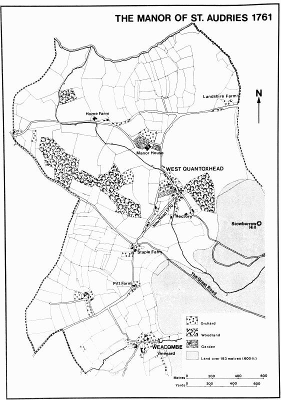
The parish of East Quantoxhead, known in the 13th century as Great Quantoxhead, (fn. 1) takes its name from its position on the headland of the Quantocks 'where seaward Quantock stands as Neptune he controld'. (fn. 2) The parish runs south from the low cliffs on the coast across a vigorously undulating coastal strip, and then up the scarp by ridge or combe to the top of the Quantocks, forming a wedge-shaped area 6.5 km. long and at most 3.5 km. wide. The whole parish comprises 946 ha. (2,338 a.), of which slightly more than half is open land on the hills. (fn. 3)
Most of the boundaries of the parish on the high ground appear to follow tracks, notably the western limit, the prehistoric Quantock ridgeway, which was still in the late 17th century the road to Taunton. (fn. 4) To the east the boundary with Kilve runs for a short distance along Hodders Combe and is thereafter an arbitrary line, often disputed in the 17th century despite a 15-ft. strip and frequent boundary cairns. One heap of stones above Short Combe was then described as 'the place of parley' about an encroachment made by the lord of Kilve manor. Towards the coast Perry Gully formed the limit on the west, and a dispute there in the late 17th century was caused by the diversion of the watercourse into West Quantoxhead. (fn. 5)
Most of the land above the 76 m. contour is on Hangman Grit, (fn. 6) and rises to over 320 m. on Black Ball Hill (Balack Hill 1687) and Thorncombe Hill. By the end of the 17th century the high ground in the parish was divided by the Great Road from Nether Stowey to Watchet: to the south lay 472 a. of the lord's common; to the north were 692 a. of the tenants. (fn. 7) Between the scarp and the coast the parish is on Keuper marls, with an outcrop of Hangman Grit and substantial patches of valley gravels and limestone from Lower Lias and Rhaetic beds. (fn. 8) A limekiln was built near the coast in the north-east c. 1797, (fn. 9) and another there and one a little further west by 1839, (fn. 10) all to burn imported stone, though a fourth near the eastern boundary by 1886 presumably produced lime from stone dug nearby. (fn. 11) The coastal area is crossed by small streams one of which, presumably that flowing through East Quantoxhead village, was bridged by the late 13th century. (fn. 12)
The headland of the Quantocks is rich in Bronze Age burial mounds and twenty-six have been identified in the parish. (fn. 13) No early signs of occupation have been recognized on the coastal strip, but two mounds, one supporting a windmill in the 18th century, (fn. 14) had begun as burial cairns. (fn. 15) There were two main settlements in the Middle Ages, both on major watercourses running from the hills. East Quantoxhead village lies largely on a single street leading south from the manor house and the church, with a westward extension along what was later called West Street, Church Path or Lane, or Underway Lane, (fn. 16) leading to the second settlement, Perry. The lane ceased to be a through route during the 19th century, and the hamlet of Perry contracted at the same time, though it had once been divided into Higher and Lower Perry, and in the early 18th century had contained at least seven dwellings. (fn. 17) The main farm there in the 14th century had a house with a temporary oratory, (fn. 18) and a dovecot and an oxhouse are mentioned in 1407–8. (fn. 19)
East of the main village the road from Perry provided a direct link through Kilve to the Luttrell property in Kilton until the late 17th century or later. (fn. 20) The route in the 1670s ran north to the coast before turning east, but claims for its repair in the manor court until 1723 suggest a more direct route beside East Wood. (fn. 21) There was also a road linking the village with Putsham, its course stopped in 1818. (fn. 22) The substantial number of travellers helped by the churchwardens in the early 17th century is evidence of the frequent use of roads through the parish. (fn. 23)
There were two, and possibly three, other medieval settlements. Combe is mentioned by 1273 and throughout the 14th century. (fn. 24) It had close links with an estate in Holford and may have been near the eastern boundary by Higher Pardlestone. (fn. 25) It was also probably near the contemporary hamlet called Domescombe, later Dennaryscombe (1394) and Dunscombe (1687), where the stream through Dun Combe or Denscombe emerges into the fields on the edge of the common. (fn. 26) The third possible settlement, perhaps representing an extension of the main village north of the manor house, seems to have lain in an area known as Plantesayssh (1407) or Plontesyaysshe (1495), the bounds of which included a field later called Plains. (fn. 27) The bounds themselves extended into the sea 'so far as the lord of the manor could ride on a horse pulling a "slegge" weighing 12 lb.'. (fn. 28) A new house was mentioned there in 1408. (fn. 29) No remains of any settlement have been found there, but closes adjoining the manor house called Town Place and Culverhays in the 17th century suggest that the present isolation of the house may have been the result of contraction of settlement. (fn. 30) In contrast, the spread of houses south of the village to Townsend, first traced in 1616, (fn. 31) and having a smithy by 1688, (fn. 32) is an indication of the growing use of the higher east-west route through the parish away from the original settlements, and the consequent decline of the road between East Quantoxhead village and Perry. Isolated cottages were built in the 18th century along steep lanes leading to the small inclosures on the edge of the common land. (fn. 33) The higher route was straightened and improved c. 1828. (fn. 34)
There is no evidence of open fields in the late 14th and the 15th century; (fn. 35) demesne pasture called West field, recorded in 1404, suggests conversion from arable, (fn. 36) but there remained a wide band of demesne arable and grassland in the centre of the parish in the late 17th century. (fn. 37) Field names of the 16th century and field patterns at Perry and south-east of East Quantoxhead village at the same date suggest the division of fields into small closes. (fn. 38) Closes called Waterleets are recorded in 1273, (fn. 39) and the name survived above Perry in the 1550s. (fn. 40) In the 18th century the mill stream in the village was diverted at weekends to flood a meadow. (fn. 41) The stream's present course is man-made.
Knowle wood and Marshwood are found in the 13th century, Northwood and Morewood in the 15th, (fn. 42) though Northwood was partly cultivated in 1407–8. (fn. 43) Knowle wood, running up the scarp in the centre of the parish, covered twice its present area in the 1680s; (fn. 44) Northwood lay in the north-eastern tip bordering the cliffs, and was surrounded by a pale in the 1490s. (fn. 45) East wood, first so named in 1723, may be the later name for Marshwood. (fn. 46) Bircham wood was established between Sheppards and Slaughterhouse combes on the Quantocks by 1687. (fn. 47)
In 1412 a 6-a. farm was let on condition that a house of three bays was built within two years. (fn. 48) Most of the buildings in the village date from the 18th or 19th centuries, and include three terraces of thatched cottages. Nearly all stand on foundations occupied in the late 17th century. (fn. 49) Nos. 43 and 45 East Quantoxhead, at the extreme south end of the village street, is a late medieval house with former open hall, a first floor having been inserted c. 1600. (fn. 50)
A beer retailer is recorded in 1894. (fn. 51) The village hall was built in 1913 in memory of Mrs. Alice Luttrell. The hall included a library and baths. (fn. 52)
The population of the parish was 151 in 1667. (fn. 53) It was 262 in 1801 and rose only slightly during the earlier 19th century to 281, and then markedly to 339 in 1861. From that year there were losses each decade until 1911 (138) and then slight recoveries until the Second World War. In 1971 the population was 131. (fn. 54)
Sarah Biffin (1784–1850), the limbless painter of miniatures, was born in the parish. (fn. 55)
MANOR.
The manor of EAST QUANTOXHEAD or GREAT QUANTOXHEAD (fn. 56) was held T.R.E. by Merlesuain. By 1086 it was owned by Ralph Pagnell, one of the two owners of the later barony of Hooton Pagnell (Yorks. W.R.). Ralph de Reuilly held the manor as his tenant. (fn. 57) Ralph Pagnell died between 1118 and 1124, and was followed by his son William (d. c. 1146). Their estate, which also included Irnham manor (Lincs.), descended through William's daughter Alice (d. before 1181) to her daughter Avice, wife of Robert de Gaunt, (fn. 58) and then to their son Maurice (d. 1230). (fn. 59) Maurice de Gaunt died without issue, and his heir was Andrew Luttrell, son of Frethesant Pagnell, Ralph Pagnell's grandchild, by Geoffrey Luttrell (I) (d. 1216–17). (fn. 60)
Andrew Luttrell succeeded in 1232, (fn. 61) and his descendants have owned the property ever since. The manor was granted by Andrew to his second son Alexander, (fn. 62) and it was later said to be held of the senior branch of the family as of the manor or barony of Irnham. (fn. 63) The overlordship thus descended from Andrew Luttrell (d. 1265), through his son Sir Geoffrey (II) (d. c. 1270) to his grandson Robert (d. 1297); it was claimed in 1366 by Sir Andrew Luttrell, (fn. 64) and in 1493 was held by the heirs of Geoffrey Luttrell. (fn. 65)
Alexander Luttrell had died by June 1273, probably on crusade. His heir, Andrew, was a minor, and his widow received not only dower but held the remainder at farm. Andrew was still alive in 1310 (fn. 66) but was probably dead by 1324. (fn. 67) The manor then passed in succession to his son Alexander (d. 1354), to Alexander's son Thomas (d. c. 1366), and to Thomas's son Sir John, K.B. (d. 1403). (fn. 68) Sir John was succeeded by his cousin, Sir Hugh Luttrell, owner of Dunster, on whose death in 1428 it passed to his son John (d. 1430). John's son and successor Sir James died of wounds after the second battle of St. Albans in 1461, and soon afterwards was attainted for his support of the Lancastrians. (fn. 69) Ten years earlier his wife Elizabeth had received the manor as part of her jointure, but her claims were over-ridden, and in 1463 the Luttrell estates were given to Sir William Herbert (cr. earl of Pembroke 1468). (fn. 70) Herbert was executed in 1469 and the manor reverted to the Crown during the minority of his heir, but from 1472 it was held by trustees, evidently for Elizabeth Luttrell's benefit. (fn. 71) By 1475 she had apparently regained her jointure. (fn. 72)
Elizabeth Luttrell died in 1493, leaving the manor to her son Sir Hugh, K.B. (d. 1521), who evidently lived there. His widow Walthean held it as her jointure until her death in the following year, having refused to be driven out by her son Andrew. (fn. 73) Andrew, who also lived on the manor, died in 1537, and his widow occupied the property until 1580. Meanwhile their son Sir John Luttrell died in 1551, leaving three daughters. Their uncle, Thomas Luttrell (d. 1571), acquired their shares between 1560 and 1569, (fn. 74) and left the reversion to his son George.
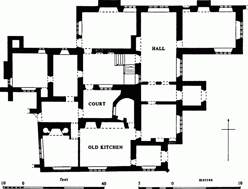
Court House, East Quantoxhead
George Luttrell died in 1629, leaving the manor in the hands of his widow Silvestra. She tyrannized her second husband, Sir Edmund Skory, and outlived both her stepson Thomas Luttrell (d. 1644) and Thomas's son and heir George (d. 1655). The manor passed on her death after 1655 to George's brother Francis Luttrell (d. 1666). (fn. 75) It thereafter descended with the main Dunster estate like the manor of Kilton. The manor house was let to tenant farmers until Alexander Fownes Luttrell went to live there in 1888. His son Geoffrey lived at Dunster, but his grandson, Lt.-Col. G. W. F. Luttrell, lordlieutenant of Somerset since 1978, lived at East Quantoxhead in 1980. (fn. 76)
The manor house, known as Court House from the 19th century, (fn. 77) stands on a knoll between the village and the sea, with the church and farm buildings on its southern side. In 1273 the house was adjoined by two stone-roofed houses, one opposite the hall, and by farm buildings, a gatehouse, gardens, and fishponds. (fn. 78) A great chamber is referred to in 1403–4, a tile-covered 'loigge' in 1421–2, and a buttery garden in 1478–9. (fn. 79) In 1408–9 a carpenter made a 'stresschold' for the oriel door and a new 'enterclose' for the oriel. (fn. 80) The plan of this evidently substantial house cannot now be recognized in the present building, but its strategic position, overlooking the Bristol Channel, might suggest that the form of the early building was determined as much by the requirements of defence as by domestic conventions.
The surviving medieval portions are an embattled four-storeyed tower and a wall adjacent to it at the south-east corner, and the short west range. The contemporary intervening buildings were removed or altered beyond recognition in a major rebuilding of the early 17th century. (fn. 81) This rebuilding appears to have taken place in two stages. The first provided a new south range with a northern return at its west end and a newel staircase at the east end of its north side. The stair turret is in the angle with the later hall range, which implies that the hall replaces an older building on its site. In the south range the principal room on the ground floor was the kitchen; on the first floor two rooms have plaster friezes and decorated overmantels, one of which is dated 1614. The second phase of rebuilding must have been separated from the first by only a few years and provided the new or reconstructed range which now forms the north and east sides of the house and a well staircase in the angle between them. The east range contains the hall, the screens passage which is entered through a two-storeyed porch, and the study which is adjacent to the old kitchen (now the estate office) and may formerly have been a service room. The upper end of the hall extends to the north wall of the house and the drawing room is in a wing which projects to the east. The decoration of the rooms in the hall and drawing room ranges is of the earlier 17th century, and one fireplace is dated 1629. Both stages of rebuilding were thus undertaken by George Luttrell (d. 1629), perhaps finished after his death by his widow; one room behind the kitchen was built by Francis Luttrell in 1689. (fn. 82)
East of the house is a walled forecourt, and gardens extend down the slopes east and south-east. To the north-east a long rectangular pond has been formed from a group of fishponds.
ECONOMIC HISTORY.
The estate in 1086 measured 7 hides; it was one of those holdings where the ploughlands, 20 in number, far exceeded the number of teams, and where the value had fallen since the Confessor's time. The demesne farm of 5¼ hides may have been predominantly under grass or uncultivated moorland, since there were only 2 ploughteams there, while the tenants had 7 teams for their 1¾ hide. (fn. 83)
The demesne in 1273 included 112 a. of arable, 10 a. of meadow, 15 a. of several pasture, and 160 a. of common pasture on Quantock. There were 2 free tenants paying rent and 9 villein tenants. Some of the arable was described as in furlongs, while the size of other areas varied from a single unit of 45a. and 20 a. in two crofts, to a small piece of 2 a. (fn. 84) During the period 1402–33 (fn. 85) the income from the manor averaged just over £41, and the sales of grain (mostly of wheat) and stock accounted for up to a third of the total. The demesne farm then included at least nine large arable inclosures, cropped in rotation; the extent of arable thus varied each year, averaging 132 a. Until 1433 sheep farming yielded usually between £4 and £5 from the sale of wool and skins, and the size of the flock (fn. 86) fluctuated, producing 644 fleeces in the best year, 1418–19, though only 18 fleeces came from reared lambs and most from wethers recently bought in Wales. Wool was sold either through the Luttrell estate surveyor or direct to purchasers, including a man from Stogursey.
The demesne farm in 1404 was staffed by a hayward, a shepherd, 4 ploughmen, 4 drovers, 2 grangers, and a dairy keeper. The dairy was mentioned infrequently: butter and cheese were produced from 11 cows in 1405–6, there were 9 cows in 1413, and the milking of 5 was sold in 1415–16. Other stock were usually few in number. Crops sown in 1405–6, reflecting the normal balance, were 104 a. of wheat, 15 a. of oats, and 24 a. divided between peas, barley, beans, and rye. Customary works were not of great significance. Services were owed according to the standard sizes of holdings: a 24-a. tenant in 1403, with an additional pasture holding, owed 2 days for ploughing and 2 for reaping, his harrowing was commuted for 1d., and he gave to the lord annually a bushel of wheat. (fn. 87) The theoretical total of works was 146 in 1402–3, but already by the 1380s cash rents had been introduced, and by 1412 all works were commuted for cash. (fn. 88)
The economy began to change in the early 1430s. The sheep flock was transferred permanently to Carhampton in 1431–2, and there was a slight decrease in demesne arable. By 1450 parts of the demesne were let, and all grain and stock were sent to the lord's household and not sold. More demesne was let in the next few years, producing over £5 in new rents; among other changes a small flock of sheep was again kept and, in 1457–8, customary works were revived. The total cash income after these changes averaged only just over £27, though the net value of the estate was probably greater than thirty years earlier. (fn. 89)
Tenant farms were reckoned by the late 14th century at 24 a., 12 a., or 6 a., and some were then being let for two lives. (fn. 90) In 1403 there were 14 holdings of 24 a., 3 of 12 a., 4 of 6 a., and there were 11 cottagers with 2 a. or 3 a. (fn. 91) Holdings like that of William Poulett called Tresouresplace in 1427–8, (fn. 92) or of John Pury, which united two customary holdings and some demesne, (fn. 93) show relatively frequent change of tenant and the engrossment of holdings. From the 1540s land was leased in relatively large units, and by the 1570s there were 8 holdings ranging in size between 40 a. and 124 a. Wheat still predominated as a crop in the 16th century, the wheatlands covering some 466 a. in the 1570s, while ryelands, probably on the hills, amounted to 55 a. (fn. 94) The legal status of tenants retained its traditional pattern, with 22 customary leases, a holding by widowhood, and 3 tenants at will in 1581. (fn. 95)
By the 1680s the demesne farm or barton, measuring 406 a., was followed in size by 4 farms of between 40 a. and 55 a. and by 11 more over 20 a. The total number of holdings, which included altogether 1,028 a. of inclosed land, was only nineteen. (fn. 96) The demesne farm was kept in hand throughout the 17th century, but for most of the 18th it was let for periods of 5, 10, or 14 years, (fn. 97) while the tenant farms were held at the beginning of the 18th century either by copyhold or leasehold for lives, on the same pattern as thirty years before. (fn. 98) Licences granted in the manor court from the 1670s onwards allowed customary tenants to let their holdings for seven years or more. (fn. 99) Leases for lives still continued on small holdings in 1834, but consolidation of larger ones was achieved, for example, at Perry under a 14-year lease in the 1790s. (fn. 100) By 1839, with a demesne farm slightly reduced in size to 381 a., there were three other substantial farms, Bakers (253 a.), Perry (196 a.), and Townsend (155 a.). (fn. 101) Those four holdings, known in 1978 as Court House, Court, Perry, and Townsend farms, continued the pattern in the 1970s.
Farming practice as revealed in covenants of the late 18th century was affected by national improvements; the growth of flax, hemp, and rape was discouraged, and turnips eaten by sheep were not regarded as a crop. (fn. 102) Lime was to be added in the usual precise quantities. (fn. 103) In 1839 there were 700 a. of arable and 273 a. of grass in the parish, with 1,135 a. of commonable land on the high ground. (fn. 104) By 1905 the land, excluding the higher parts of the parish, was almost equally divided between arable and grassland. (fn. 105) By 1976 arable had increased to about 60 per cent of the total. (fn. 106) Farming was almost the sole occupation in the parish by the mid 19th century, and the four main farms employed 52 men between them in 1851. (fn. 107) The stock on Court farm in 1853 included 315 sheep, 63 head of cattle including 16 oxen, and 5 colts. (fn. 108) Farming in the 1970s involved dairying, cattle, and sheep. (fn. 109)
The value of the commonable half of the parish is difficult to assess. General rights to graze and dig turf existed in the Middle Ages, (fn. 110) and the manor court supervized the repair of a common way there. (fn. 111) Unspecified areas of the common were noted as cultivated in 1454–5 and in the early 17th century, both probably on what was described as the lord's share of the common, in the 17th century for growing rye. (fn. 112) Unlicensed removal of furze, stones, and turf is recorded in the 16th and 17th centuries, and burning heath was prohibited in 1716. (fn. 113) In 1608 grazing on the northern part of the common was ordered to be restricted to customary tenants, (fn. 114) while the lord's share in the 1680s comprised pastures for wild bullocks. (fn. 115) The lord was responsible for all access gates, (fn. 116) and in 1724 he let a site for a cottage in Quantock Hill lane in return for maintaining the 'lord's bounds and banks' there. The new tenant was given 1,000 turves a year from 'the outer common called Lady's common'. (fn. 117) Common rights on the Quantocks were long established by the 18th century; for example a holding of 2 a. in the village had common for 20 sheep, 1 bullock or colt, and 2 days cut of turf by one man, (fn. 118) and the miller, with 4 a., could graze horses or cut turf. (fn. 119)
The beach and the sea contributed little to the income of the manor, but the lord used stones from the beach for building, (fn. 120) let certain fishing grounds, controlled the burning of seaweed, and until the end of the 18th century claimed wrecks. (fn. 121) Fishing from the ridge, an offshore bank, was let in the early 15th century, (fn. 122) but tenants could presumably fish from the shore, and until the 20th century used dogs to search for congers under the rocks. (fn. 123) The foreshore was let from the early 16th century for the collection and burning of seaweed. Surviving leases divided the coast into two or three areas and restricted burning to prevent smoke reaching the manor house. (fn. 124) The practice still continued in 1602. (fn. 125)
A clothing industry was established in the parish by the early 17th century. There was a dyehouse on the manor by 1611, (fn. 126) and by the 1670s it was held by the Shurt family, who were described as clothiers. (fn. 127) Two producers of serge were also there in the 17th century, (fn. 128) and cloth was racked in the village. (fn. 129) Clothiers, weavers, and tailors occur in small numbers throughout the 18th century, and include Philip Hellicar, formerly of Bicknoller, who had an interest in mining speculation in East Quantoxhead and later moved to Williton. (fn. 130) In the 1770s manor officers noted that courts should not be held in the village to clash with Wells fair, since the clothiers would be absent. (fn. 131) The industry evidently died out soon after 1800.
Search for copper ore in the parish, and also in Kilton, began shortly before 1713, and in the following year a mining lease granted to a London merchant and a group of local tradesmen refers to pits and mines already opened 'at Perry hill or Quantock'. (fn. 132) No further reference to mining has been found in the parish.
Six masons in the parish in 1851 probably worked at the quarries at West Quantoxhead, but the 3 carpenters and 3 blacksmiths found employment enough at home. There was then one shop. (fn. 133) By 1906 apartments were being offered to holiday makers, and by 1931 tea rooms had been opened. (fn. 134) The picturesque village was a popular attraction for visitors in the 1970s.
Mill.
There was a mill on the demesne in 1086; (fn. 135) by 1341 it had two pairs of stones. (fn. 136) By the late 17th century it was usually let for periods of 7 years, (fn. 137) and by 1711 was held for a time by the tenant of the demesne farm. (fn. 138) In 1725 it was described as lately burnt, and the present mill house, a two-storeyed building of rubble with a thatched roof, is dated 1729. (fn. 139) The mill continued in operation as a flour mill until the early 1920s. (fn. 140)
LOCAL GOVERNMENT.
The tithing of East Quantoxhead, which included the manor of Beggearn Huish in Nettlecombe, was constituted in the time of Maurice de Gaunt (d. 1230). (fn. 141) There are rolls or extracts from courts held for East Quantoxhead manor for most years in the period 1382–1428, and for scattered sessions in 45 years between 1446 and 1592; for the periods 1593–1615 and 1675–80 the records are continuous. (fn. 142) Extracts, copies of presentments, and precepts survive for 1655 and for the periods 1682–1728, 1755–79, and 1820–90. (fn. 143) Courts were normally held twice a year and were usually described as leet or manor courts. The phrase 'view of frankpledge' was introduced by 1520 and was used regularly twice a year from the 1580s. (fn. 144) From 1691 until 1728 or later the Easter or Hockday court was discontinued, but it was revived again in the period 1755–9. (fn. 145) Thereafter annual courts, described in the 1760s as 'court leet and baron for the manor and borough', were normally held in late October. (fn. 146)
Sessions were held at the church house, the 'ancient and customary place', by 1722. (fn. 147) By 1772 the church house had become dilapidated, and in that year and in 1779 courts were held at the home of one of the court jurors. By 1865 and until 1886 sessions were held at the manor house, hence its name Court House, but from 1887, when Alexander Fownes Luttrell was preparing to take up permanent residence there, until 1890 or later, the court sat at Blanchflowers Farm. (fn. 148)
By the early 15th century the Michaelmas court was submitting names for the office of reeve, and itself appointed the hayward. The choice of tithingman seems also to have been made by the Michaelmas court by 1417. The reeve was probably no longer chosen by the court after the early 16th century, when the manor was administered with Kilton, but the court continued to appoint the tithingman and one or more haywards. The office of manor hayward is not found after 1604, and by the 1680s tenants served as tithingman in rotation or by deputy. The office continued until replaced by that of constable in 1842, and the constable served the precept on suitors until the 1870s. The office of pound keeper occurs between 1820 and 1890.
Like the court at Kilton, the manor court in the early 15th century seems to have been closely involved with the sale of grazing, stock, and produce, and regularly from 1408 for nearly 20 years included details of sales of wool and losses of sheep by disease. (fn. 149) The maintenance of watercourses and trespasses on common were regular concerns in the 15th and 16th centuries, and from the 17th the survival of rights of way from the village to Kilve church and to the shore. (fn. 150) House and bridge repairs were frequently demanded from the 17th century. The court ordered the parish to provide a new pair of stocks in 1688, (fn. 151) and presented the tithing in 1708 for allowing the cucking stool and pillory to become damaged. The stocks were reported as out of repair in 1756. (fn. 152)
Parish accounts in 1605 were agreed by 6 men and 'all the rest', (fn. 153) and the rector, the wardens, the tithingman, and 7 others signed the appointment of highway surveyors in 1690. (fn. 154) In the 18th century nominations of wardens and overseers were made by the minister and between 2 and 6 people. There were normally two wardens, both nominated by the parish except between 1769 and 1799, and two overseers. There were two highway surveyors for some years after 1689. The office of overseer was held in rotation according to property qualifications. (fn. 155) The overseers regularly paid house rents and bought goods and clothing, and in the 1650s rented the church house, presumably for paupers. (fn. 156) In 1818 a house in the centre of the village was used as a poorhouse. (fn. 157) The parish became part of the Williton poor-law union in 1836, and joined Williton rural district in 1894 and the West Somerset district in 1974. (fn. 158)
CHURCH.
There was a church at East Quantoxhead by 1259 when the advowson formed part of an estate bought by Henry de Gaunt for St. Mark's Hospital, Bristol. Possession was confirmed to the hospital in 1268, (fn. 159) but Andrew Luttrell (d. 1265) also claimed ownership, and gave the advowson to his second son Alexander. (fn. 160) The bishop of Bath and Wells appointed to the living in 1265 by authority of the King's council, (fn. 161) presumably before a settlement was reached. The Luttrells had established their claim by 1329 (fn. 162) and thereafter the advowson descended with the manor. Trustees of James Luttrell appointed in 1442, Thomas Malet presented in 1484 in right of his wife Elizabeth, James Luttrell's widow, John Wyndham in 1543 as a trustee, and William Foster, clerk, in 1799 by grant of Francis Luttrell. The bishop appointed by lapse in 1766 and 1779. (fn. 163) The living was a sole rectory until 1975; it was held with Kilve and Kilton until 1978 and then became part of the benefice of Quantoxhead. Lt.Col. G. W. F. Luttrell is one of three joint patrons of the benefice. (fn. 164)
The rectory was valued at £10 13s. 4d. in 1291 (fn. 165) and at £10 0s. 4d. net in 1535. (fn. 166) The reputed value was £80 c. 1668, (fn. 167) and the net income was £325 in 1831. (fn. 168) The tithes in 1535 amounted to £8 16s. 4d. (fn. 169) and were commuted in 1839 to a rent charge of £265. (fn. 170) In 1630 the tithes included the right shoulder of every deer taken in the park, and were payable in kind on wool, lambs, calves, pigs, geese, apples, pears, hops, honey, and wax. There were moduses for hay from ancient meadow, milk, and first calves. (fn. 171) The glebe was worth 24s. in 1535, (fn. 172) and measured 27 a. in 1571 and apparently over 30 a. in 1630. (fn. 173) By 1839 the land was in a compact unit of just over 28 a. (fn. 174)
In 1635 the parsonage house included a hall and a great buttery with two chambers over it. Outbuildings comprised two barns, a stable, and a square house in the outer court gate. Many of the buildings were then dilapidated, and an additional wing on the house was unfinished. (fn. 175) That house stood until 1763, when it was virtually uninhabitable, and by 1799 there was said to be no house on the benefice. (fn. 176) A new house, designed by George Gale of Dunster, (fn. 177) was largely built between 1806 and 1810. (fn. 178) It was altered and extended in the 1830s or 1840s, and a verandah was added after 1880. The house was occupied by successive rectors until 1975, and was subsequently sold and renamed West House. The remains of the former house stand below the stable block.
Andrew Luttrell, presented as rector by his elder brother in 1329 before he was in major orders, was absent for study for at least two years, and in 1337 spent a year in his brother's service. (fn. 179) Richard Puldon, rector by 1366, surrendered to the Fleet prison in 1370 after outlawry for debt. (fn. 180) Richard Pynwyn, rector by 1440 and until 1442, was given three years leave of absence for medical treatment for his eyes. (fn. 181) The parish clerk was reported in 1612 as usually reading divine service when the minister was away, and at certain times also reading a homily. (fn. 182) William Bisse, rector 1634–77, escaped sequestration by the 'interest of a great man of the times', but his property was plundered 'several times'. (fn. 183) During the vacancy before his arrival the Laudian furnishings were installed, (fn. 184) but the communion rails were broken up in 1646 and the royal arms defaced in 1650. (fn. 185) The church was extensively repaired and decorated in 1698. (fn. 186)
During the later 18th century absentee rectors left most of the work to curates, partly for lack of a house. (fn. 187) At least two rectors, Leonard Herring (1763–6) and Laurence Luxton (1816–18), undertook to resign the living in favour of any member of the Luttrell family. Alexander Fownes Luttrell, rector 1818–88, was presented on Luxton's resignation. (fn. 188) In 1776 there were nine regular communicants, (fn. 189) and the pattern of quarterly celebrations was unchanged from the 1600s until the 1870s or later. (fn. 190) Two Sunday services were normal during the 19th century, and on Census Sunday 1851 there were congregations of 27 in the morning and 120 in the afternoon, with 37 Sunday-school children at each service. (fn. 191)
By 1597 the church house, standing on the south side of the mill pond, was let by the lord of the manor. (fn. 192) In the 1650s it was occupied by the overseers and later by individual tenants, and by 1722 part was used for the manor court. (fn. 193) It was still standing in 1794, when it comprised three rooms on the ground floor, two occupied as shops, and a single room above. (fn. 194) It had been demolished by 1839. (fn. 195)
There was a light before the image of the Virgin from 1403, (fn. 196) and by 1548 there were other endowed lights. (fn. 197) Blessed bread and a candle were given to the church by the manor in 1427–8 in respect of a tenement then in hand. (fn. 198)
The church of ST. MARY comprises a chancel with north vestry, nave with south porch, and west tower, and stands close to the south side of Court House above the village. The vestry stands on the site of a larger north chancel aisle. An altar recently dedicated in 1329 (fn. 199) and the surviving tower arch suggest an early 14th-century date for the origin of the present building. Foundations dug on the site in 1427–8 may have been connected with new work during refenestration. (fn. 200) The vestry was probably added during restoration in the 19th century. The rood screen may date from the late 14th century, and was formerly topped with a wide loft. The elaborate canopied tomb chest in the chancel, used as an Easter Sepulchre when the chancel aisle was standing, commemorates Hugh (d. 1521) and Andrew Luttrell (d. 1537). Andrew requested burial before the picture of Our Lady on the north side of the altar, and the window above was to be newly made. (fn. 201) The pulpit, reader's desk, communion rail, and benches date from the early 16th and the 17th century. (fn. 202)
The registers date from 1559 and are complete. (fn. 203)
NONCONFORMITY.
There was one family of recusants in 1636, and it had been joined by Dame Silvestra Skory and a married couple by 1642. One recusant at least remained in the parish in 1654. (fn. 204)
EDUCATION.
There seems to have been a school in the parish in 1646. (fn. 205) A school established by 1819 (fn. 206) had 60 children by 1825, of whom 50 attended on weekdays and all on Sundays. (fn. 207) The school was affiliated with the National Society by 1835, (fn. 208) and by 1839 was held in a building in the village street adjoining the cottage known in 1978 as no. 38 East Quantoxhead. (fn. 209) In 1846–7 there were 47 children on the books, of whom 33 attended both day and Sunday school and the remainder the Sunday school only. The school was largely supported by the rector, with parental contributions. (fn. 210) In 1876 G. F. Luttrell provided a new building on the road between East Quantoxhead and Kilve, to be shared between the two villages. Kilve and East Quantoxhead Council school, on its transfer to the county council in 1903, had 44 children on the books. (fn. 211) From 1930 only infants and juniors were taken. It was closed in 1971 and children have since attended school in Williton. (fn. 212)
CHARITIES FOR THE POOR.
James Houndrell, possibly the benefactor to Kilton or his namesake at Kilve, (fn. 213) gave £20 to the second poor of East Quantoxhead, producing £1 a year. (fn. 214) The charity was said c. 1824 to have been augmented by a gift of £5 by a Mr. Pugsley at 'some distant period'. (fn. 215) William Hawkes (d. 1792) gave £100 and John Feltham (d. 1816) a similar sum. (fn. 216) In 1819 the capital, formerly in private hands, was invested to produce just over £10 a year, given in clothing at Christmas by the wardens. (fn. 217) In 1869–71 the income was £10 1s. 10d. (fn. 218) Alexander Fownes Luttrell, rector 1818–88, bequeathed £200 to the trustees of what was then known as the Parochial Charity, (fn. 219) and the annual income in 1891 was £15 14s. 10d. (fn. 220) In 1965 the charity was distributed between 11 recipients; in 1981 2 people received £7.50p. each. (fn. 221) Between 1700 and 1749 twenty people described as almsmen and almswomen were buried in the parish. (fn. 222)