A History of the County of Somerset: Volume 9, Glastonbury and Street. Originally published by Victoria County History, London, 2006.
This free content was digitised by double rekeying. All rights reserved.
M C Siraut, A T Thacker, Elizabeth Williamson, 'Parishes: West Bradley', in A History of the County of Somerset: Volume 9, Glastonbury and Street, ed. R W Dunning (London, 2006), British History Online https://www.british-history.ac.uk/vch/som/vol9/pp75-82 [accessed 30 April 2025].
M C Siraut, A T Thacker, Elizabeth Williamson, 'Parishes: West Bradley', in A History of the County of Somerset: Volume 9, Glastonbury and Street. Edited by R W Dunning (London, 2006), British History Online, accessed April 30, 2025, https://www.british-history.ac.uk/vch/som/vol9/pp75-82.
M C Siraut, A T Thacker, Elizabeth Williamson. "Parishes: West Bradley". A History of the County of Somerset: Volume 9, Glastonbury and Street. Ed. R W Dunning (London, 2006), British History Online. Web. 30 April 2025. https://www.british-history.ac.uk/vch/som/vol9/pp75-82.
In this section
WEST BRADLEY
The parish of West Bradley, formerly a chapelry within the parish of East Pennard, lies south of Pennard Hill, 6 km. south-east of Glastonbury. It contained three small settlements, West Bradley, including the church and West Bradley House, in the centre, Plot Street to the west, and part of Parbrook to the east within a roughly rectangular area measuring 1 km. from north to south and 2.5 km. from east to west. (fn. 1) East Bradley, recorded in the 17th and 18th centuries, seems to have been the south-eastern part of the chapelry which lay outside the boundary of Glastonbury Twelve Hides. (fn. 2) There were detached fields to the west in West Pennard and to the south in Baltonsborough resulting from inclosure, probably in the later 17th century. (fn. 3) West Bradley measured 626 a. in 1843. (fn. 4) Lottisham was joined to it in 1879, (fn. 5) but in 1884 it lost those areas surrounded by Baltonsborough. The resulting parish measured 1,410 a. in 1901. In 1933 Hornblotton was added to create a civil parish which in 1991 covered 1,017 ha. (2,513 a.). (fn. 6)
The parish lies on Lower Lias clay and slopes gently from just over 40 m. (131 ft.) on the northern boundary to the Coxbridge brook which marks the southern boundary, and which itself flows from below the 30-m. (98-ft.) contour near Parbrook to just above the 10-m. (33-ft.) contour. The Bradley brook runs south-west across the grounds of West Bradley house. (fn. 7)
A network of small roads and footpaths crosses the parish and the principal route between East Pennard and Glastonbury forms much of its northern boundary. A branch from that road follows the Bradley brook to Plot Street and thence, via modern footpaths, to Havyatt in West Pennard and thereafter Glastonbury. (fn. 8)
Population, Settlement And Buildings
There were 30 households in 1563 (fn. 9) and in 1641 48 males. (fn. 10) In the late 18th century there were said to be c. 110 inhabitants in 20 houses. (fn. 11) In 1801 the population was 116 and had risen to 132 by 1831. There appears to have been a shortage of housing with no increase between the 1780s and 1830s. (fn. 12) The population fluctuated thereafter, reaching a peak of 176 in 1871 before declining to 132 in 1881 and to 103 in 1901. The addition of Lottisham and Hornblotton increased the population to 250 at which it remained during the 20th century. (fn. 13)

FIG. 35. West Bradley parish in 1843
The development of three small settlements instead of one village may be due to the position of the arable land, especially the North field between Plot Street and West Bradley, and the need to utilise the land along the brooks for meadow which left little suitable building land. (fn. 14) Parbrook, the largest settlement, was shared with Ditcheat and East Pennard; Plot Street has signs of shrinkage. (fn. 15) At least one medieval house site lay east of the church (fn. 16) in West Bradley whose name indicates its early situation surrounded by woodland. (fn. 17) In the 17th and 18th century there were several houses at Kenter's Green, a small common shared with Baltonsborough, south of Plot Street. (fn. 18) The larger houses such as Newhouse Farm, Higher Farmhouse, and Bradley Farm date from the 19th century. The medieval Court Barn, part of Glastonbury rectory, (fn. 19) in the extreme west of the parish, housed six labouring families which in 1871 numbered 28 persons, including three lodgers. (fn. 20) Conditions were insanitary in 1875 when most of the poor relied on rainwater pools and of the few wells two were stinking. (fn. 21)
Events And Social Life
The actress Henrietta Keasberry died at West Bradley in 1812. (fn. 22) The West Bradley Amateur Dramatic Company was mentioned in 1894 (fn. 23) and there was a tennis club in the early 20th century. (fn. 24) A hut capable of seating 50 people was used as a social centre in 1947 but the parishioners were said to show little desire for a social life and there were no recreational facilities in 1981. (fn. 25)
MANOR AND ESTATE
West Bradley Manor
In 746 King Ethelbald is said to have sold an estate in Bradley to Glastonbury abbey. (fn. 26) It was claimed that Abbot Aethelnoth appropriated land there in 1079 to benefit the poor. (fn. 27) The hide of thegnland in Pennarminster which Ailmar held in 1066 and Serlo de Burci held of the abbot of Glastonbury in 1086 has been identified as West Bradley. (fn. 28) On Serlo's death c. 1086 the estate probably reverted to the abbot. (fn. 29) Overlordship remained with the abbey until the Dissolution. (fn. 30)
Robert Cumin did homage to the abbot of Glastonbury for a hide in Bradley in 1189 (fn. 31) and the land may have been held by his widow in 1196. (fn. 32) By 1233 it appears to have been held by William Carbonel and his wife Denise. William was dead by 1256 when Peter Carbonel gave Denise, wife of Thomas of Bradley and probably William's widow, a life interest. (fn. 33) Hugh de Waleys was said to hold the fee c. 1260, (fn. 34) possibly by curtesy, as in 1264 it was held by Sir Thomas Carbonel. (fn. 35) Thomas was followed in turn by John (fl. c. 1285) (fn. 36) and by John's sons Robert (d. s.p. by 1299) and Peter, although Robert's widow Joan may have had a life interest, as Peter did not do fealty until 1304. (fn. 37) Peter died in 1328 leaving a widow Isabel (fl. 1346) and a son John. (fn. 38) John was dead by 1363 (fn. 39) when Bradley manor was divided. One half passed to (Sir) John Kentwood through his marriage to John Carbonel's widow Alice, and he held it for her life with remainder to Alice, wife of Nicholas Barun (d. 1375). The other half was shared between Joan, wife of Roger Smale, and Isabel, wife of Henry Merston. Joan released her quarter share to John Kentwood in 1368 and Isabel her quarter in 1375. Kentwood acquired Alice Barun's rights in 1379 from William of Barton to whom she had sold them. (fn. 40)
Sir John Kentwood died in 1394 but his wife Alice survived until 1404 or later. (fn. 41) Nicholas Kentwood, probably their son or grandson, died in possession of Bradley manor c. 1412 leaving a widow Isabel. (fn. 42) By his former wife, Maud Sackville, Nicholas had a son Robert (fl. 1468) (fn. 43) whose son John died without male issue in 1487. In 1499 John's heirs were his sisters Elizabeth, wife of John Swaffield, and Frideswide, wife of Richard Fetiplace. (fn. 44)
By 1503 the manor was occupied by Richard Norreys (fn. 45) who with his wife Eleanor acquired in 1507 the half share held by John Swaffield and his wife Elizabeth. By 1525 the whole was in the possession of Henry Brydges (d. 1538–9) who seems to have settled it on his son (Sir) Richard and Richard's first wife Anne. (fn. 46) Anthony, son of Sir Richard (d. 1558), succeeded as a minor (fn. 47) but in 1566 made a release to his brother Edmund under the terms of their father's will. (fn. 48) Edmund leased it to Robert Foliat (d. 1610) with reversion to his own son William. William, however, was in 1617 declared a lunatic and ownership passed to his brother Anthony. (fn. 49) In 1619 Edmund Brydges, perhaps Anthony's brother, seems to have been in possession with Katharine, possibly his mother. (fn. 50) Edmund Brydges died in 1634 (fn. 51) and was followed by John Brydges (fn. 52) who died c. 1673 having already in 1662 sold a substantial amount of land to John Peirs. (fn. 53)
The land and lordship not sold were subject to an order in Chancery. (fn. 54) In 1679 the lordship and a small estate were bought by Tobias Chandler, who in 1691 conveyed them to Edmund Dawe to whom he had offered them some years before. (fn. 55) Dawe appears to have settled the manor on his daughter Elizabeth (d. 1699) for her marriage to Dr. Claver Morris in 1696. Morris (d. 1727) remained in possession and in 1705, following his third marriage, seems to have made a new settlement with Dawe, presumably for the benefit of Dawe's granddaughter Elizabeth Morris. (fn. 56) Elizabeth (d. 1760) survived her husband John Burland and was succeeded by her eldest son, also John Burland, but in 1768 the manor was settled on his sister Anne (d. by 1797) for her marriage to the Revd. William Keate of Wookey (d. 1795). (fn. 57) In 1797 Anne's son Thomas Morris Keate sold his share to Thomas Keate who in 1801 with the other four children of Anne and William sold the manor and lands to Thomas Maidment. (fn. 58) Thomas died in 1826 and in 1831 his widow was in possession, but by 1836 his son Levi held the manor. (fn. 59) Levi (d. 1865) left his estate to trustees who conveyed them to Levi's son Thomas Maidment (d. 1887) and to the latter's trustees including his son Charles (d. 1920). (fn. 60) Lordship was not recorded again.
The former manorial land was sold to John Peirs in 1662, presumably in trust for William Peirs (d. 1670), bishop of Bath and Wells. Ownership descended in the direct male line to the bishop's son William (d. 1682), successively archdeacon of Bath and Taunton, and to his grandson William (d. 1687). (fn. 61) William Peirs (d. 1764), son of the last, was succeeded by his son, also William (d. 1765), who left West Bradley to his sister Elizabeth, wife of Lord Montagu Bertie. (fn. 62) In 1768 Elizabeth sold the house to the Revd. Richard Symes for life with remainder to his son Richard. In 1781 it was settled on the younger Richard's marriage. (fn. 63) Much of the estate had already been sold (fn. 64) and by 1842 the house had been bought by Frederick Grey and was let. (fn. 65) In 1859 it was bought by William Allen (d. 1900) who was followed by his son, also William (d. 1950), and grandson William. (fn. 66) In 1998 it was the property of Mr. and Mrs. E. CliftonBrown.
Manor House
The court and dovehouse of the capital messuage were recorded in 1503 and were then in the possession of Richard Norreys. It was said to have been the former residence of Almery, steward of Bradley. (fn. 67) It was evidently let to members of the Foliat family during the 16th century (fn. 68) but in 1662 passed with most of the manorial land to the Peirs family. In 1665 it was occupied by people too poor to pay hearth tax although there were 11 hearths in the house. (fn. 69) Its exact site is unknown but it may have been near the site of the present house.
West Bradley House is a small house of c. 1720 built by William Peirs using workmen from Wells. (fn. 70) It has three storeys and attics, each storey built of different coloured coursed rubble with limestone string courses, quoins, and window surrounds. It has an irregular octagonal plan, of great curiosity for its date, formed by a square with two-bayed sides, each corner having a slightly projecting bay at 45 degrees. Internally the angled bays have little significance to the shape of the rooms, and fireplaces are positioned so that flues run up either side of each bay with those on the top floor placed against blind windows. By c. 1785 sashes had replaced mullioned windows, (fn. 71) the mullions being used to form windows when the cellar was converted into a service basement. The staircase hall had been created by 1810 (fn. 72) when a new central doorway was provided on the south side, in place of a large four-centred arch, and a tall staircase window on the north. It may have been at that date that the roofline was altered, exposing a double-pitch roof running east-west. Tudor-style chimneypieces in the drawing room, formerly two rooms, appear to be of similar date. Later in the 19th century the roof was altered to a single pitch and broader chimney stacks were built. The north-east room was remodelled as a dining room and was given two new windows. A single-storey service wing was built to the north-east and bathrooms added in the former stairwell, necessitating the remodelling of the staircase. A wing parallel to the service wing was added in the late 20th century.
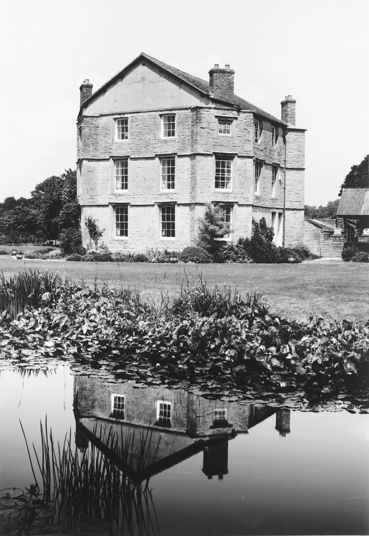
FIG. 36. West Bradley House, 2001
In 1726 Mr Long, a Dutchman, was employed to work on the gardens, constructing canals, waterworks, walks, and 'knots', but those were later allowed to go to ruin and before 1750 the newly-planted oak, ash, and elm had been cut down and an avenue of young oaks removed to Baltonsborough. (fn. 73) Ponds and wilderness were mentioned in 1768. (fn. 74) The long canal parallel with the south front and aligned on the church is likely to be contemporary with the house; the present water stairs at its east end seem to be a modern version of earlier ones. Also probably of early 18th-century origins were an avenue aligned on the north-west angle of the house, and a walled garden north of the house with a lodge by the gate. The other three angles of the house may have been planned to relate to other avenues or vistas including one ending with the church. By 1810 there was a railed forecourt to the house, and another to the church. (fn. 75)
Rectory Estate
Tithes and glebe in West Bradley were part of East Pennard rectory, appropriated by Glastonbury abbey and assigned to the sacrist c. 1200. (fn. 76) By 1540 the Bradley tithes were farmed with West Pennard (fn. 77) and from 1548 were held by the bishop of Bath and Wells with the rectory of St John's, Glastonbury. (fn. 78) In 1705 they were known as the Sexton's, probably a corruption of Sacrist's. The small tithes of the west of the parish also belonged to the rector. (fn. 79) In 1842 the rectorial tithes were commuted for a rent charge of £34 to the bishop's lessees. (fn. 80) About 12 a. in the extreme north-west of West Bradley was held by the bishop's lessees with West Pennard rectory, including the medieval Parson's Barn, now known as Court Barn. (fn. 81) It is not clear if this had been West Bradley's part of the East Pennard glebe granted to the sacrist. (fn. 82) Court barn is a 15th-century building of coursed rubble with a double tier cruck roof and a few remaining windbraces. It was restored in the 1930s. (fn. 83)
ECONOMIC HISTORY
Agriculture
In 1086 the estate identified as West Bradley was assessed at one hide and there were four villeins with two teams. No demesne arable or stock was recorded but there were 8 a. of meadow and 30 a. of wood. The whole estate was worth 30s. (fn. 84) The manor was said to be worth £20 in 1412 (fn. 85) and in the 1530s Glastonbury abbey received from the rectorial estate over £8 in rent and £5 in tithes. (fn. 86)
Open-field arable must have predominated during the Middle Ages and the principal open arable lay in North and South fields in the centre of the parish, Bower field, also known as Bower wood, north of Parbrook in the east, Chedbreach in the north-west, and Kenter's Green in the west. (fn. 87) Lack of pasture meant that grazing was found through intercommoning arrangements in Common moor in Baltonsborough, Kennard moor in West Pennard and Glastonbury, and Baltonsborough North wood. Common was for all beasts without stint. (fn. 88)
Most land was in closes by the later 17th century when there were many small holdings. By the 1680s and 1690s, following the sale of the manor, some cottages had been demolished and a rental of 1691 listed less than half as many tenants as one of 1671. Some rents were much higher. (fn. 89) Most of the holdings purchased with the lordship in 1691 were of 3 a. or less and the largest tenement contained 22 a. (fn. 90) In 1734 the Bradley House estate had been increased to nearly 330 a. and a further four holdings were over 20 a. but ten measured 5 a. or less. (fn. 91) Arable land appears to have been converted to grass during the 18th century or early 19th century. (fn. 92) By c. 1785 there were 9 scattered farms (fn. 93) whose rents had been increased by 1770; even small holdings were let at rack rent. (fn. 94) In 1835 31 a. of orchard was recorded with c. 62 a. of arable, 7 a. of garden, and 527 a. of grass. Of 25 families, 22 were engaged in husbandry. (fn. 95) By 1842 there were only 26 a. of arable and 24 a. of orchard; 389 a. were under grass. Only two farms were over 100 a.; a further three were between 50 a. and 100 a., two between 25 a. and 50 a., and three between 10 a. and 25 a. There were no major landowners although the Maidment family held over 275 a. (fn. 96)
In 1691 two tenants paid increased rents if their apples did well. (fn. 97) Dairying was of considerable importance in the 18th century and in 1726 a large quantity of cheese from the Bradley House estate was sent to St. Giles's fair at Winchester. In 1768 there were 209 a. of mowing meadow. (fn. 98) In 1801 a farm had a field called Milking pen (fn. 99) and a farm account recorded breeding cows, sales of butter and cheese including large quantities to a cheeseman, and purchase of veterinary medicine. (fn. 100) Two dairymen were recorded in 1851 (fn. 101) and Cheddar cheese was said to have been made extensively in the parish. William Allen of Bradley House was noted for his cheesemaking (fn. 102) and created New House farm (95 a.) east of the house before 1881 when Bradley farm covered 350 a. (fn. 103) In 1900 the Allen family's large herd of cows and farm equipment were sold and they turned to cider production. (fn. 104) However, dairy farming continued to predominate in the 20th century and in 1998 Bradley farm (c. 300 a.) was a dairy farm. Apples were also grown on the Bradley House estate and elsewhere in the parish. (fn. 105)
Mill
There was a mill in 1468–9 (fn. 106) and a watermill south-west of the church in 1503. (fn. 107) It was known as Marsh's mill in 1674, (fn. 108) was still in use in 1720, (fn. 109) and was sold with Bradley House in 1768. (fn. 110) It may already have gone out of use and had been demolished by 1842. The former mill pond may account for the sharp bends in the lane. (fn. 111)
There was no record of a windmill but a field south-east of the church was known as Toot field and contained a clay mound now largely destroyed. (fn. 112)
Trades And Services
The surnames Roper, Brewer, and Cooper were recorded in 1327 and there was a cooper in the parish in 1599. (fn. 113) In 1841 a butcher and a mantua maker were recorded and in 1851 and 1881 two glovers. (fn. 114) In 1919 there was a large bakehouse on Parbrook Lane next to a wheelwright's shop. (fn. 115) During the 20th century there was no local employment other than agriculture and there were no shops or services. (fn. 116)
In 1315 two men were accused of selling ale by false measure. (fn. 117) In 1632 a couple sold beer and had dancing in their house. (fn. 118) Victuallers licensed in 1674, 1675, and 1753 (fn. 119) probably all kept an inn, known by 1711 as the Bradley Inn and recorded in 1768, which stood east of the church beside the lane to West Pennard. It appears to have closed by 1842 although the name Inn Orchard survived. (fn. 120)
LOCAL GOVERNMENT
West Bradley was divided between Glastonbury Twelve Hides and Whitstone hundreds, the boundary in part approximating to the lane past the church. (fn. 121) In the 14th and 15th centuries the tithingman attended some sessions of the Whitstone hundred court. (fn. 122) The division continued into the 19th century for land tax purposes. The land in Whitstone hundred was sometimes known as the East tithing or East Bradley tithing. (fn. 123)
No manor court records have been found but courts were held for Glastonbury's land in the chapelry in the 1530s (fn. 124) and an annual court for Bradley manor in 1599. (fn. 125) The manorial pound lay south of the road between the church and Parbrook. (fn. 126)
Two churchwardens and two overseers for West Bradley were recorded in 1641, and operated separately from East Pennard. (fn. 127) By the early 18th century there were only one churchwarden, one overseer, and one waywarden and the overseer and waywarden shared an account book. (fn. 128) A vestry met in the 18th and early 19th centuries to order poor relief and to place parish apprentices. A spinning turn was bought in 1777 and in 1814 a midwife was paid to attend a pauper. A poorhouse was recorded in 1714 and a new house for the poor, at Parbrook, of stone, brick, and tile, was built in 1793 at a cost of over £107. This house remained in use in 1834. The poorhouse had been disposed of before 1842. (fn. 129)
West Bradley formed part of the Wells poor-law union from 1836 until 1882 when it was transferred to the Shepton Mallet union. From 1894 it was part of Shepton Mallet rural district which was absorbed into Mendip district in 1974. (fn. 130)
CHURCH
Origins And Endowment
West Bradley was until 1875 (fn. 131) a chapelry of East Pennard and its church had the status of a dependent chapel. A chapel was first recorded in 1168. (fn. 132) In 1875 the chapelry was detached to form a new parish of West Bradley and Lottisham. (fn. 133) From 1965 until 1980 the parish was held with West Pennard, (fn. 134) and from 1980 it was held with Butleigh and Baltonsborough. (fn. 135)
Successive vicars of East Pennard were responsible for serving the chapel until 1875, the vicars themselves being appointed before the Dissolution by Glastonbury abbey and afterwards by members of the Coward family until c. 1713 when patronage passed to the bishop of Bath and Wells. (fn. 136) The bishops appointed vicars to West Bradley after 1875. (fn. 137)
By 1705 payment to the vicar for the west part of West Bradley was taking the form of offerings of 2d. from each parishioner there. (fn. 138) In 1746 the church was worth c. £10 a year. (fn. 139) In 1842 the vicar of East Pennard as perpetual curate of West Bradley received a rent charge of £50 in lieu of small tithes. (fn. 140) In 1345 the resident chaplain had a house which contained an oratory, (fn. 141) and from 1449 the parishioners provided the chaplain with a house to the west of the church. (fn. 142)
Pastoral Care And Parish Life
In the 14th and 15th centuries the chapelry was served either by resident chaplains (fn. 143) or by vicars of East Pennard. (fn. 144) In 1438 the vicar was required to serve the chapel every Sunday and feast day and on the fourth and sixth days of the week. (fn. 145) A decade later the vicar was required to provide a chaplain at his own expense. (fn. 146) After the Dissolution there is no record of resident clergy. In the early 18th and the early 19th centuries there were services only once every three weeks, and the churchwardens sometimes had to pay a minister to serve. (fn. 147) By 1827 there was a service each Sunday. (fn. 148) On Census Sunday 1851 c. 105 people attended an afternoon service but some may have been from East Pennard; services were normally held alternately morning and afternoon. There were 12 Sunday schoolchildren. (fn. 149)
There was an endowed light in 1548. (fn. 150) In 1637 the church was well furnished with linen, surplices, and books. (fn. 151) A west gallery was considered in 1840 but it is not clear if it was built. In 1849 there were a paid organist and singers. (fn. 152) The former chaplain's house may have been used as a church house (fn. 153) and in 1571 was described as two houses in the churchyard belonging to the glebe, but was not claimed as glebe in 1634. (fn. 154) In the later 18th century and until 1869 it was the home of the parish clerk. (fn. 155) It was demolished after 1910. (fn. 156)
Church Building
The church, dedicated to St. Andrew only since the late 20th century and probably before then having no dedication, may well until restoration have had a piscina and corbels in the chancel which dated to the 13th century. (fn. 157) The earliest parts of the surviving fabric indicate the rebuilding in the late 14th or the 15th century of the nave, perhaps 12th century in origin, and the addition of the south porch, and west tower with lierne vault. The kingpost roof of the nave with embattled tie beam, the rood stair turret and the formerly traceried south door (fn. 158) suggest work in the late Middle Ages. Parts of the building were reported decayed in 1552, 1557, and 1612. (fn. 159)
The church was renovated in 1852, (fn. 160) and completely restored in 1873–4 when the organ chamber was added on the north side of the chancel. (fn. 161) The tower was repaired in 1893, and the chancel arch required underpinning in 1898. (fn. 162) All the windows and furnishings, apart from the plain tub font, are of the 19th century.
There are two bells of 1706 by Thomas Purdue and Thomas Knight and a third of 1815 by James Wells of Aldbourne (Wilts). (fn. 163) A clock was bought in 1739. (fn. 164) The plate includes an Elizabethan cup and cover by 'I.P.' found and restored c. 1852 when a second paten was made to match. (fn. 165) The octagonal socket of the churchyard cross remains. (fn. 166)
NONCONFORMITY
Ebenezer Bible Christian chapel at Plot Street was licensed for worship in 1837. (fn. 167) It seated 112 and on Census Sunday 1851 50 people attended in the morning and 100 in the afternoon. (fn. 168) It became part of the United Methodist circuit in 1907 but appears to have closed by 1932. (fn. 169) The building was a private house in 1998. It is built of coursed rubble under a pyramidal slate roof in an early 19th-century Gothick style re-using salvaged materials. There are Y-traceried windows and a carving of the Agnus Dei on its main front.
EDUCATION
There was no school in 1819 (fn. 170) but a parochial school had been established by 1847 with 19 children on weekdays and an additional boy who attended on Sundays only. (fn. 171) There were two teachers in the parish in 1851 (fn. 172) and the church infant school was recorded in 1866. (fn. 173) In 1875 a school board for West Bradley and Lottisham Green was formed, (fn. 174) and children attended a school at Lottisham in Ditcheat parish. (fn. 175)