A History of the County of Somerset: Volume 1. Originally published by Victoria County History, London, 1906.
This free content was digitised by double rekeying. All rights reserved.
'Geology', in A History of the County of Somerset: Volume 1, (London, 1906) pp. 1-33. British History Online https://www.british-history.ac.uk/vch/som/vol1/pp1-33 [accessed 8 May 2024]
In this section
GEOLOGY
Few counties in England present so great a diversity of scenery as Somerset, and none possesses a greater variety of geological formations. Although the land nowhere attains the dignity of a mountain, yet the older rocks which form the more solid framework of the county stand out boldly on Exmoor and in the Quantock Hills of west Somerset, in Crook Peak and other portions of the Mendip Hills, and rise to a lesser elevation on Broadfield Down in north Somerset. Along the borders of the county to the east and south-east there are ranges of secondary rocks, connected north of Bath with the Cotteswold Hills, and extending southwards in a series of escarpments to the neighbourhood of Wincanton and Yeovil, and thence along the Blackdown Hills to near Wellington. They form a kind of crescent, from the centre of which the older rocks of Mendip proceed westwards. Between these hilly grounds fertile vales and rich moorlands stretch irregularly inland from the shores of the Bristol Channel.
The stratified and igneous rocks met with are as follows:—
With such a list of formations the great diversity of soil and feature in Somerset will readily be understood. The soils indeed are but little modified by material drifted from a distance; they are due so directly to the outcropping formations that geological boundary lines may be traced across ploughed fields from the evidence of weathered fragments of the underlying rocks. On the elevated moorlands of Exmoor and the Quantocks the heather, dwarf oak and whortleberry abound, and the red deer in places runs wild. On the tablelands of Mendip and Broadfield Down, amidst wild and cultivated tracts, we find excellent pasturage for sheep. The Oolitic and Liassic uplands are partly under plough cultivation, while the slopes of these stonebrash hills are studded with orchards. The clay vales of Lias and New Red Marl form rich pastures, and the levels in particular are noted grazing and dairy lands, one of the products being the famous Cheddar cheese. More than half the land is under permanent pasture, and the county is essentially an agricultural one; but it is by no means wholly so—there are mines of coal and iron, famous building stones, fullers' earth, peat moors or turbary lands, lime and cement works, and formerly there were important mines of lead and zinc of which the refuse heaps are now worked.
As might be expected Somerset has had a considerable share in the development of geological knowledge. As early as 1719 the relations of its Coal Measures to the overlying 'Red earth' and 'Lyas' were pointed out by John Strachey, while towards the close of the eighteenth century William Smith, 'the father of English Geology,' was actively engaged in setting out and superintending the works for the Somerset coal canal, thereby gathering much of that knowledge of the succession of the strata and of their characteristic fossils which formed so important a part of the foundation of geological science. (fn. 1) Subsequently Buckland, W. D. Conybeare, Thomas Weaver and William Lonsdale determined the geological structure of various portions of the county in the masterly way characteristic of those old workers. The Geological Survey under the direction of De la Beche depicted on maps the superficial areas over which the many different strata are exposed, a task aided by William Sanders of Bristol, who afterwards personally surveyed a large part of Somerset between Bristol and the Mendip Hills, and published in 1862 a map on the scale of 4 inches to a mile.
The researches of numerous other observers during the latter half of the nineteenth century largely increased our knowledge, and among these we are indebted especially to Charles Moore of Bath. Since his death local interest in geology has ever been fostered by the Rev. H. H. Winwood, also of Bath. (fn. 2)
DEVONIAN
Geologists are far from unanimous with regard to the age and correlation of some of the grits and slates met with in that large and picturesque moorland region of west Somerset which extends from the Quantock Hills on the east to Exmoor on the west. (fn. 3)
The rocks classed as Devonian are there so folded and faulted that no reliable estimates can be made of their thickness, but the main lithological groups can be traced across country through Exmoor with generally an east and west strike to the Quantocks, where the general trend is north-west and south-east; and these divisions, first marked out by Etheridge, have been surveyed in more detail by Mr. W. A. E. Ussher. Later researches have however thrown considerable doubt on the regularity of the succession which they depicted. (fn. 4)
On parts of Exmoor and the Brendon Hills (1,344 feet high) there is a group of much folded and highly cleaved slates, known as the Morte Slates, which for many years were regarded as an unfossiliferous set of beds overlying the Ilfracombe group in the Middle Devonian series.
In 1890, however, the late Dr. Henry Hicks discovered fossils in these Morte Slates at Woolacombe in north Devon, and elsewhere in the neighbourhood. Although the specimens were much distorted and in a bad state of preservation, he was able to recognize Lingula, Orthis, Stricklandinia, Cardiola, and some others of Silurian aspect, and he maintained that the rocks were the oldest in north Devon. (fn. 5) Continuing his researches into west Somerset, Dr. Hicks was successful in finding fossils in the Morte Slates of the Oakhampton slate quarry near Wiveliscombe, and in calcareous bands in the slates at Treborough on the Brendon Hills. Here he obtained the trilobites Homalonotus and Dalmanites, also Strophomena, Chonetes, and other forms suggestive of the Lower Devonian period. (fn. 6) These observations led Dr. Hicks to conclude that in the Morte Slates we have life-zones belonging to both Upper Silurian and Lower Devonian, and although his views have not as yet been fully accepted, his discovery of fossils in beds previously regarded as barren is of the utmost importance, while his contention that the beds in west Somerset are Lower, rather than Middle, Devonian has received the support of the Rev. G. F. Whidborne and Mr. J. E. Marr.
The famous iron ores of the Exmoor and Brendon Hills occur in these slaty rocks, and for the most part above certain calcareous bands which are impersistently seen in the slates. The late Sir Warington Smyth observed that these 'ores of iron occur both in regular strata and in veins; and it is evident that they were known and worked by our forefathers, although the common tradition of their having been opened by the Romans, and the term "Roman Vein" attached to one locality would seem, I think, of less weight than the probability of their having been wrought about the time when Queen Elizabeth invited German miners to England, supported as it is by the name Eyesen Hill by which one of the ancient workings is still known.' (fn. 7) Nodules of iron ore have been met with in the shales in the Exe valley north-east of Simonsbath, but the ore has been obtained mainly from lodes which have been extensively worked at Raleigh's Cross in the Brendon Hills, where one lode is from 2 to 20 feet wide. The lodes yield brown iron ore, with also goethite and much manganese ore, occasionally copper pyrites, and some hæmatite (red iron ore) at the surface, whilst at a depth the brown ore passes into sparry ore (carbonate of iron). According to Smyth a series of parallel fissures must originally have been opened in the slaty rocks, nearly concordant with the general planes of stratification. These, after being filled with carbonate of iron, some quartz and fragments of the containing rock, were dislocated, while much of the ore was changed from carbonate to peroxide of iron. The occurrence of pebbles of hæmatite in the New Red strata of west Somerset seems to indicate that the infilling of the fissures was of earlier date than those red rocks.
Elsewhere among the older Devonian Rocks the Foreland Grits, comprising the fine grained red, grey and purplish grits, extending from the Foreland in Devonshire to Porlock Hill, rise up in North Hill and Grabbist Hill to the west and south of Minehead, and again appear in Dunster Park. On the coast they form bold precipitous fronts to the stormy seas of the Bristol Channel. Resting apparently upon these grits, though in faulted relationship with them in west Somerset are the slaty grits and schists known as the Lynton Beds, which yield Spirifer hystericus, and appear at Oare and the north end of Luccot Hill. The connection between these rocks and the Morte Slates has yet to be determined.
The Lynton Beds are surmounted by a great series known as the Hangman Grits, which include fine and coarse grained grits, speckled with red, and contain some slaty bands and occasional fossils such as Natica and Myalina. These rocks, which may possibly be equivalent to the Foreland Sandstones, form fine moorland ranges, including the prominent Dunkery Beacon (1,707 feet), Croydon Hill (1,251 feet), and the higher portions of the Quantocks with Wills Neck (1,261 feet).
Above the Hangman Grits is a series known as the Ilfracombe Slates, comprising slates with occasional bands of limestone, which are sometimes conspicuous, but elsewhere occur in strings, and these in many places have been entirely dissolved away along the outcrop.
These rocks are described by Mr. Ussher as forming high longbacked ranges, with frequent conical hills of lesser elevation than the grits below and above them. They extend from Exmoor towards the Brendon Hills, and occur on the eastern borders of the Quantocks, where at Great Holwell, Asholt and Dodington the limestones are best developed. Here the Rev. H. H. Winwood found a number of fossils, including crinoids, brachiopods, and the coral Favosites cervicornis. Gritty beds locally occur in this division as noted by Mr. Ussher, and these appear in inliers among the New Red rocks east of the Quantocks.
Still higher in succession is a third series of grits, the Pickwell Down Sandstones, variously coloured green, grey and purple grits with slates, which form barren moorlands intersected by the river Barle north-west of Dulverton, and extending eastwards by Winsford and Exton Hills and over Haddon Down.
To the south of Dulverton there is a tract of the higher Devonian slaty and gritty rocks grouped as Baggy and Pilton Beds, which pass upwards into the Lower Culm Measures near Brushford. These Lower Carboniferous rocks, so well known to the south at Bampton in Devonshire, do not enter conspicuously into the geology of west Somerset, although strata of equivalent age occur elsewhere in the county as noted further on.
In the great mass of Devonian rocks, which represent the hardened sands and muds of ancient sea bottoms, there are evidences of local volcanic activity in certain ashy beds which occur at the base of the Ilfracombe Series between Cockercombe and Adscombe on the Quantocks.
In the Morte Series there is a rock referred to by Mr. Ussher as the Bittadon felsite, which outcrops east of Exton Hill at Armoor and Withiel Florey 'apparently at or near the same horizon' (fn. 8); while a syenitic rock was observed many years ago by Leonard Horner in the Ilfracombe Series at Hestercombe, north of Taunton, where the adjacent slates have been altered into a kind of hone stone.
The economic products of the Devonian rocks include the iron ores before mentioned, as well as slates and other materials employed for local building purposes and road metal.
If the Lower Devonian rocks merge into the Upper Silurian, so do the Upper Devonian into the Carboniferous, and there is every probability that the usually accepted Devonian group of Devonshire is in reality a more comprehensive system than the Old Red Sandstone which it has been taken to represent. Mr. Ussher indeed has remarked 'that the Upper Devonian Beds may be in part at least equivalent to what is called the Lower Carboniferous Slate Series of the south of Ireland; and if so, such correlations as the Pickwell Down Beds with the Upper Old Red Sandstone are natural.' The strata may be grouped as follows :— (fn. 9)
UPPER OLD RED SANDSTONE
The Old Red Sandstone which forms a nucleus to the Mendip Hills, and rises at intervals from near Frome to Black Down north of Cheddar, consists for the most part of red and variegated sandstone, with sandy marls and towards the upper part beds of quartzose conglomerate. The conglomerates are conspicuous between Downhead and Beacon Hill to the north-west of Shepton Mallet, where in places they have been disintegrated into a loose gravel.
The Old Red Sandstone also occurs at Portishead and along the shores of the Avon near Abbots Leigh. Remains of the fish Holoptychius have been recorded from Portishead, otherwise but few traces of fossils have been found in this formation in Somerset.
On the Mendips the rock forms tracts of moorland together with pasture and arable ground, but the soil, a reddish stony loam, is not rich. Springs issue at the junction with the Lower Limestone Shales, which flank the Old Red Sandstone and hold up water in the joints and weathered portions of that formation. Economically the rock is not much used, except for building walls and for local road mending.
On the summit of the Mendips, extending westwards from Downhead to Beacon Hill, there are masses of igneous rock (andesite) sufficiently hard to be quarried for road metal at Moon's Hill south of Stoke Lane. Attention was first called to these exposures by Charles Moore, and they have since been frequently examined. According to Sir A. Geikie and Mr. A. Strahan they appear to rise intrusively through the Old Red Sandstone, and may possibly belong to the Carboniferous volcanic series referred to later on.
CARBONIFEROUS LIMESTONE SERIES
The lowest Carboniferous strata in east Somerset are the Lower Limestone Shales which occur between the Old Red Sandstone and the Carboniferous Limestone. They form passage-beds and are well shown above Burrington Combe on the Mendips and in the Avon gorge. In the ascending series we find that the higher beds of Old Red Sandstone alternate with shales and thence merge into the main mass of greenish grey and bluish-grey shales, above which the shales alternate with bands of limestone, which pass gradually into the Carboniferous Limestone.
Fossils are not uncommon in these beds; they include the trilobite, Phillipsia, also many fish-remains, crinoids, bryozoa, and brachiopods such as Spirifera, Chonetes and Strophomena.
The shales which occur between the harder masses of Old Red Sandstone and Carboniferous Limestone have suffered erosion so that they occupy belts of lower ground often wet and boggy from the direct rainfall or from springs which issue from the bordering rocks. In bygone days these shales, which are sometimes black, have led to fruitless trials for coal.
The Carboniferous or Mountain Limestone forms some of the more picturesque parts of Somerset, and it well deserves the name of 'Scar Limestone,' which it received in the north of England on account of the numerous scarps of rock which characterize the land. In Somerset it forms the mass of the Mendip Hills, with its many charming rocky gorges, combes and caverns, as at Cheddar, Ebbor, Burrington and Frome on the Mendips, at Cleeve and Brockley on Broadfield Down. While however the rock frequently appears at the surface, there is elsewhere a rich red soil, a residue from the decomposition of the rock, and this supports an excellent herbage for sheep.
A fine section of the rocks is to be seen in the gorge of the Avon, where it cuts Leigh Down in Somerset, and Clifton and Durdham Downs in Gloucestershire. The upward succession from the Old Red Sandstone and Lower Limestone Shales may be traced from Cook's Folly towards Clifton, where the Upper Limestone Shales and Millstone Grit appear. The Carboniferous Limestone is there to a considerable extent repeated by the Great Clifton fault, which has thrown down the beds on the north to an extent estimated by Prof. C. Lloyd Morgan at 1,100 feet. (fn. 10) This great dislocation has produced much disturbance in the strata. The lower portion of the Carboniferous Limestone, seen in the Black Rock quarry, comprises dark bituminous limestone crowded with crinoid remains, Spirifera, etc.; higher up there occur bands with many fish remains, then a series of oolitic limestones, and some shaly beds; while in the upper beds we find layers with Terebratula hastata and Productus, others with the trilobite Phillipsia, also Orthoceras, Bellerophon, Murchisonia and Euomphalus, and corals such as Lithostrotion and Cyathophyllum. The upper beds are worked in the Great quarry of Durdham Down, where fluor-spar occurs in crevices of the rock.
Near the Suspension Bridge at St. Vincent's Rocks the famous Hotwell Spring of Clifton issues from the higher beds of the Limestone 'at the rate of 60 gallons per minute, at a tolerably uniform temperature of 70° Fahr.' Its principal constituent is carbonate of lime; it contains also salts of soda and magnesia, but only to the extent of 44 grains to the gallon. (fn. 11)
The thermal waters of Bath which issue through the Keuper and Rhætic Beds probably arise also from the Carboniferous Limestone. (fn. 12) Judging by their temperature, 104 to 120° Fahr., Prestwich suggested that the depth from which they come is about 3,500 feet. Hence they may be regarded as natural artesian wells, fed perhaps to some extent from the sea, which in the Severn estuary is bordered in places by Carboniferous Limestone, and this rock also rises up in the Holmes islets. The chief ingredient in the waters is sulphate of lime, with also sulphate and chloride of sodium, and chloride of magnesium, etc. Altogether they contain from 144 to 168 grains per gallon, and the discharge is about 385,000 gallons daily. Traces of copper and other metals have been found in the Bath waters, and in connection with them it is interesting to bear in mind that almost every element is contained in sea water, while in the Carboniferous Limestone of Walton near Clevedon traces of gold as well as silver have been found. It should also be mentioned that at Bathampton Spa tepid saline waters were encountered in a boring, and saline waters were tapped in a coal-shaft at Twerton.
The Bath waters often bring up sand as well as nuts, insects and even fossils from the alluvial deposits and other strata through which they emerge; moreover they leave a deep red ochreous deposit, and tinge with a red colour the bordering rocks.
The surface of the Carboniferous Limestone is so fissured and jointed that water readily finds its way downwards, and impurities also are readily washed in; hence while considerable reservoirs of water occur in fissures and caverns below ground, there is no certainty of finding a copious and wholesome supply at any particular spot.
Since British and Roman times ores of lead and zinc (galena and calamine), as well as ochres, have been obtained from the Carboniferous Limestone and Dolomitic Conglomerate. In the time of Edward IV. there were established certain 'Laws and Orders of the Mendip Miners,' which contain interesting clauses connected with the working of the ores. (fn. 13) The extent of the old workings is shown by the 'hills and hollows' that occur here and there on the Mendip plateau, from Green Ore, Egar (or Eaker) Hill and Priddy, northwestwards to Charterhouse Warren, Rowberrow and Shipham.
In old times shafts were sunk to depths of 6 or 12 fathoms, and rarely to 20 or 30 fathoms. The ores were sometimes found in regular courses or grooves, whence the old miners were known as 'groovers,' and the mineral veins were found especially in the Carboniferous Limestone, and occasionally in the Dolomitic Conglomerate. At other times the ores occurred in large masses or hulks lying horizontally; in these cases in the Dolomitic Conglomerate. Particular accounts of the methods of mining have been published by Giles Pooley and others. (fn. 14)
For many years no fresh material has been obtained from the rocks, lead being procured in sufficient quantities from the slags and slimes left by the old workers. Large accumulations of this kind have been found here and there at Stoke Hill, near Priddy, Charterhouse, East Harptree, and in the Tar valley near Chewton Mendip. In all cases the deposits are found on or near areas of Lower Limestone Shales, as in such situations water was held up and could be utilized for washing the material that had been brought from the mines. The fine silty material or slime, when calcined, yields about 5 per cent of lead, and the slags yield about 20 per cent, the average being about 12½ per cent. The slags left by the Romans have proved to be the richest.
In 1890 manganese-ore and iron-ore (hæmatite) were worked at Dursdon at the head of Ebbor Gorge. Trenches excavated in the Dolomitic Conglomerate showed nests of manganese-ore, associated with a little copper-ore, cerussite (carbonate of lead) and mendipite (oxychloride of lead). The occurrence of mendipite was interesting, as it had hitherto only been recorded from Churchill. Quite recently Mr. L. J. Spencer has detected crystals of leadhillite (sulphate and carbonate of lead) in the ancient slags.
A small mass of Carboniferous Limestone, at one time thought to be Devonian, appears at Cannington Park, north-west of Bridgewater. It has yielded Lithostrotion and other Carboniferous fossils. (fn. 15) Its relations to the Devonian rocks near by are not clear owing to coverings of Trias, and although there is no evidence of unconformity Mr. Ussher is inclined to think that a pre-Triassic fault of great magnitude may occur there and stretch eastwards between Glastonbury and Shepton Mallet. This might affect the underground extent of Coal Measures, and there fore he would commend trial-borings for coal at Highbridge, Burnham, Wedmore, or Mark, rather than in the area to the south of the supposed fault. (fn. 16)
There is evidence of volcanic activity in Carboniferous times in Somerset as in Derbyshire, and further particulars have recently been gathered by Sir A. Geikie and Mr. A. Strahan, who observe that successive outflows of vesicular lava and showers of volcanic detritus were here and there spread over the floor of the sea in which the Carboniferous Limestone was deposited. (fn. 17) No evidence of any central vent was observed, but it is probable there were orifices near Weston-super-mare, Uphill and Wrington Warren. Near Weston the volcanic rocks appear at Spring Cove and at Middle Hope.
The Upper Limestone Shales, although not represented on the Geological Survey map, were long ago recognized by Buckland and Conybeare; they comprise shales with bands of limestone and grit, and are exposed in the Avon gorge, where their thickness is estimated at 600 feet by Prof. Lloyd Morgan.
Representatives of these beds should be looked for between Mells Green and Ashwick, as well as near Emborrow and to the south-west of Ebbor Rocks, where doubt has been thrown on the occurrence of Lower Limestone Shales locally marked on the Geological Survey map. It would be interesting to find evidence of beds corresponding in character with the chert beds and culm limestones with Posidonomya becheri, which occur near Bampton and Burlescombe in Devon.
These Lower Carboniferous strata were all deposited in marine areas, with in places bands and reefs of coral.
MILLSTONE GRIT
This formation comprises beds of hard close-grained grit or quartzite with ferruginous specks, and with subordinate beds of shale and occasional seams of coal. It has received the name of 'Farewell Rock,' from the fact that when reached in mining there is no longer any chance of getting profitable coal.
Fossils mostly in the form of casts are met with, and they have been described in an essay by Fort-Major Thomas Austin. (fn. 18) Shallowwater conditions prevailed at this period, the formation being probably of estuarine origin.
The stone has in places been quarried for building material and road stone, and here and there it has yielded a good deal of hæmatite. It appears in the Avon gorge by the Hotwells, on the western side of Ashton Vale, at Leigh Down near Winford, and between Binegar and Mells on the northern side of the Mendip Hills. Traces occur near Ebbor and Dinder on the southern side of the range. The absence of any outcrop of Millstone Grit near Clevedon, Clapton-in-Gordano and Tickenham may be due to faulting.
COAL MEASURES
The Carboniferous Limestone and other strata, including the Coal Measures, have been bent into folds, in the hollows of which we find those portions of the conformable Coal Measures that have escaped denudation.
Three of these Coal basins are exposed or partially exposed at the surface: (1) That of Radstock, which is connected with the Bristol Coalfield; (2) that of Nailsea; and (3) that of Clapton-in-Gordano. To the south of the Mendips there is doubtless another tract of Coal Measures beneath the vale which extends from Brent Knoll to Glastonbury and Evercreech.
The limits of the basins to the north of the Mendips can be fairly well defined, but those of the probable basin on the south are wholly unknown (see p. 10). Nevertheless there is no unexplored tract in England from which coal might so confidently be expected as in this southern area beneath the Lias and New Red rocks, at a depth approximately of about 1,000 feet; and it will be observed that to the north of the Mendips the Coal Measures occupy the lower grounds and are there largely concealed by Lias and New Red rocks which were deposited to some extent in a broad channel hollowed out of the softer Carboniferous strata.
The scenery of the coal districts in Somerset is far more agreeable than in some other coalfields in this country, because so much of the area is covered with the fertile Red Marls and other secondary strata. These indeed are locally so reduced in thickness that coal is worked near Radstock beneath the Inferior Oolite.
Some picturesque parts of the Coal tract are formed by the Pennant Grit which stands out boldly in wooded heights near Temple Cloud, Pensford, and along the Avon between Keynsham and Bristol. These sandstone rocks hold much water, but it is not as a rule serviceable for domestic supplies. The soil, a sandy loam, is not very fertile, nor is that on the shaly portions of the Coal Measures which give rise to a yellow clay. In places where there is much iron ore in the strata the soil is a bright red, often brighter in colour than that yielded by the New Red rocks.
For our knowledge of the Coal Measures we are indebted largely to the observations of the late G. C. Greenwell, J. Anstie, and J. Prestwich, but chiefly to Mr. J. McMurtrie of Radstock, who is still at work in the area.
The strata are generally divided as follows:—
The district about Radstock is noted for the variety and excellent preservation of the fossil plants in the Coal Measures.
In the Upper Series the best seam of coal does not exceed 2 feet 4 inches in thickness; in the Lower Series there is a seam 8 feet thick. As remarked by Mr. McMurtrie it is mainly owing to its geographical position, being (at present) the most southerly coalfield of England, that the thin seams met with, especially in the Upper Series, have been worked with profit. He adds that 'one favourable feature connected with the Somerset and Bristol coalfield deserves to be mentioned, namely, the absence of fire-damp, which in practice has not been met with at all in the Upper Division, and in the Lower Division is chiefly confined to the deeper seams of the Vobster and the Nettlebridge valley, Ashton Vale and Bedminster, so that the district has to a large extent been spared from those disastrous explosions which unhappily occur in other parts of Great Britain.' (fn. 19) The deepest mine at Farrington is 1,794 feet, where some of the lower seams in the Farrington series are now being worked.
Many remarkable dislocations and disturbances have affected the Coal Measures, especially in the vicinity of the Mendip Hills, where the beds are so crushed and folded that the same seam has been passed through two or three times in a shaft. The softer Coal Measures have been much more contorted than the bordering hard rocks. The Radstock slide-fault or overlap-fault is a dislocation or overthrust whereby the strata are locally duplicated over a breadth of 350 yards in a fairly horizontal manner, the vertical displacement amounting to about 60 yards.
Connected with these disturbances and with the folds which occur in the Mendip Hills are the isolated masses of Carboniferous Limestone which occur at Luckington and Vobster. These masses have been attributed to overfolding from the Mendip Hills, to an independent inverted and faulted anticline, and to a thrust-plane. (fn. 20)
Although the general structure of the Mendip Hills is usually expressed in the term 'Mendip anticlinal,' the tableland is in reality formed of a series of denuded anticlines which trend in an easterly and westerly direction, and thus do not coincide with the north-westerly and south-easterly direction of the range. There is evidence of at least five folds, the summits of which in four instances, Beacon Hill, Pen Hill, North Hill and Black Down, have been laid bare sufficiently to expose the Old Red Sandstone. As in the case of other noteworthy folds in the secondary rocks of the south and south-east of England, the strata on the northern sides of these anticlines usually plunge downwards more steeply than on the southern side, and there are vertical strata and symptoms of overfolding at Churchill Batch, near East End, Leigh-uponMendip, and in the Steep Holme which is a continuation of the Black Down anticline.
In the Clapton-in-Gordano district there are also tracts of Carboniferous Limestone overlying Coal Measures, and the structure has in Professor Lloyd Morgan's opinion been produced by a double system of faulting. (fn. 21)
The disturbances in the Somerset coalfield are of a character similar to those well known to have affected the coalfields of Belgium and the north of France, where faults, contortions and overthrusts are the rule rather than the exception.
The highest strata in the coalfield, as remarked by Mr. McMurtrie, occur probably near Pensford, where there is a considerable thickness of unproductive strata above the Radstock series. (fn. 22)
The formation was laid down over an extensive estuarine and fluviatile area, with marshy tracts where luxuriant growths of giant clubmosses, horsetails (Equisetaceæ) and ferns furnished material for the seams of coal.
There is abundant evidence of great unconformity between the Carboniferous and other older rocks and the secondary strata. Excellent examples are to be seen in the vales near Frome and Wells, and in the Avon gorge near Bristol; moreover remarkably even eroded surfaces of highly inclined strata are sometimes preserved beneath a mass of Dolomitic Conglomerate, Lias, or Inferior Oolite. These old platforms occur at various levels beneath the main plain of denudation of the Mendips, and for the most part represent different stages of erosion, although locally they may be displaced by faults.
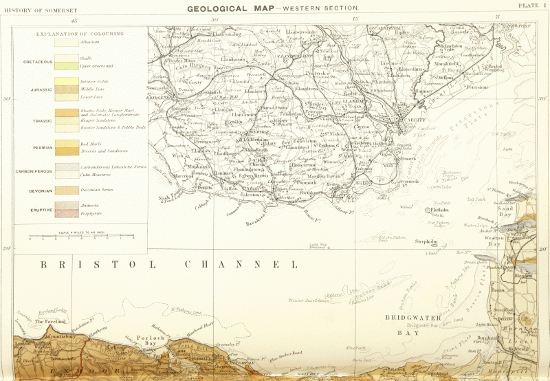
Geological Map of West Somerset
The break between the Coal Measures and the New Red rocks was marked by considerable disturbance of the older rocks, the Mendip anticlines and coal basins were produced with their attendant dislocations, and the whole area suffered vast denudation. Ramsay calculated that the loss from Mendip amounted in places to 6,000 feet. (fn. 23) In any case the present tableland is a plain of erosion, dating originally from PermoTriassic times and being perhaps again and again buried up and revealed and further wasted away during later periods.
The secondary strata commencing with the New Red rocks were for the most part deposited in a subsiding area so that newer layers stretched over a wider tract and overlapped those previously laid down.
NEW RED SANDSTONE SERIES OR PERMO-TRIASSIC
Resting for the most part irregularly on the worn surfaces and upturned edges of the older rocks is the great series of New Red rocks, which in west Somerset probably include strata of Permian and Triassic ages. These were for the most part accumulated in a large inland sea area, an arid region with sand drifts and saline waters.
A traverse of the country from Wiveliscombe to Taunton shows the following succession:—
These divisions are again met with in the vale which extends to Stogumber, but in Mr. Ussher's opinion the higher strata overlap and entirely conceal the lower as we proceed from Williton westwards to Porlock. (fn. 24) Throughout this district the rocks are a good deal faulted, and although the main sequence is well established the subdivisions are themselves subject to so much local change that it is difficult to interpret some areas.
The Breccias are made up mainly of fragments of Devonian slate and grit, and are well seen near Stogumber. They are irregularly interstratified with sandstone. The Lower Marls are used for brick making near Wiveliscombe.
The Conglomerates are of a more mixed character than the Breccias and contain, in addition to fragments of grit and slate, large pebbles of Devonian and Carboniferous Limestone which are picked out in the quarries for lime burning; while the rock itself is worked for building purposes, as at Tipnoller near Wiveliscombe and Vellow near Stogumber. In aspect it resembles the Dolomitic Conglomerate of the Mendips, but is in the main of older date.
The Upper Sandstone forms a pleasant country with deep sandy lanes near Wellington, Milverton, Halse, Williton and Minehead, and also in places along the southern and eastern sides of the Quantocks. It may be seen again near Yatton, Chew Magna, Brislington and St. Anne's by Bristol. Both sandstones and conglomerate are usually good waterbearing strata.
The Upper (Keuper) Marls which extend over the vale of Taunton border the Devonian rocks along the western side of the Quantocks with a steep easterly dip. Here however we find no evidence of an ancient cliffmargin, and probably the older rocks of Quantock were not above water during the Triassic and Liassic periods. The Marls extend to Carhampton, Dunster, Minehead and Porlock, but they are best exhibited in the cliffs on either side of Watchet and also on the foreshore, where they occur in faulted relationship with the Rhætic Beds and Lower Lias. Here much gypsum or alabaster occurs in the cliffs: it appears in nodules, bands and also in veins which traverse the beds in all directions. It is found also near Somerton.
Over this intervening area the Marls fringe the marsh lands and form islands in it. At Compton Dundon a boring was carried to a depth of 519 feet in search of Coal Measures, but although the locality is a promising one the boring was not carried deep enough to reach the base of the Upper or Keuper Marls.
Approaching the Mendip Hills we find evidence of marginal accumulations in the Dolomitic Conglomerate—beds of breccia and conglomerate formed mainly of angular and rounded fragments of Carboniferous Limestone, cemented sometimes by a dolomitic (or magnesian limestone) matrix, more often by ferruginous matter and carbonate of lime. Much of the limestone material is evidently due to subaerial waste of the land, being talus or angular detritus cemented at or near the spots where it accumulated, while other portions have been more or less rolled. Remnants of this Dolomitic Conglomerate occur along the higher grounds of Mendip as well as along the borders of the range, where the marls and conglomerate dovetail one into the other ; while in the Radstock coal field to the north of the Mendips the conglomerate is generally found at the base of the marls.
These facts indicate that while the conglomerate originated at the early stages of the Keuper period, its formation continued along the margin of the area of deposition until the close of the period.
At Draycot near Cheddar the stone has been quarried for building purposes, while near West Harptree some hard siliceous beds occur in association with the marls and conglomerates.
Fine sections of Conglomerate have been opened in the Avon gorge, where Dinosaurian remains were found. Here too, as near Wells and elsewhere, celestite (sulphate of strontian) and baryto-celestite have been found, as well as 'potato-stones,' geodes lined with calcite and quartz crystals (known locally as 'Bristol diamonds'). The Marls extend over the Vale of Wrington and Ashton Vale, and everywhere they yield a fertile soil, supporting good meadow and pasture land as well as orchards.
At Winford there are 'reddle pits,' or ochre and umber works, in ferruginous deposits which occur at the base of the New Red rocks and in joints and hollows of the subjacent Carboniferous rocks.
The Rhætic Beds, the latest stage of the Trias, form a connecting link between that system and the Lias. In general they comprise the following subdivisions:—
These beds are well exhibited on the coast at Blue Anchor, Watchet, St. Audries and in many an inland section, notably at Queen Camel, Puriton, Shepton Mallet, Uphill, Saltford and Pylle Hill south of Bristol. They occur in the escarpment of the Polden Hills, where as elsewhere the junction of the green and grey marls with the underlying red marls is often conspicuously shown in the ploughed fields.
The green and grey marls are linked by some authorities with the Keuper marls into which they graduate, but they indicate the beginning of the change which ushered in the Rhætic fauna, they have yielded similar fish remains, while the black marly bands and the pale limestone bands seen in the green and grey marls at St. Audries foreshadow the black shales and White Lias.
The fossils indicate conditions of an inland salt lake subject to irruptions of the sea, a phase which occurred between the inland sea or lacustrine conditions of the Keuper and the open sea conditions of the Lias. Among the characteristic fossils are Avicula contorta, Pecten valoniensis, Cardium rhæticum, Pleurophorus and Gervillia, as well as fish remains and plant remains (Naiadita). (fn. 25)
In fissures of the Carboniferous Limestone near Frome many Rhætic fossils were obtained including the oldest known mammal Microlestes, and teeth of the fishes Acrodus, Hybodus, Gyrolepis and Saurichthys.
One of the most remarkable bands in the Rhætic series is the Landscape Marble so well known to visitors at Clifton near Bristol. (fn. 26) The stone, which is from an inch or two to about 8 inches in thickness, occurs at the base of the White Lias and is sometimes represented by a persistent layer of banded limestone of compact texture. Where this limestone occurs in isolated and more or less nodular masses with a crinkly surface, there the aborescent markings which pervade the stone are met with. The darker patches which represent the landscape are tinted by carbonaceous matter, and the features have been attributed to the escape of bubbles of gas; while the crinkly surfaces and some modifications of the landscape, which varies considerably, appear to be due to the changes produced amid the variously tinted calcareous mud during its solidification.
Sandy beds with Pullastra arenicola occur on Harptree Hill and near Wedmore, a locality where there is a hard shelly limestone used for building stone.
A sulphur spring at Queen Camel rises probably at the base of the White Lias from the decomposition of pyrites in the Rhætic shales. Limited supplies of good water are sometimes obtained from the White Lias.
LIAS
The Lias formation occupies a considerable portion of Somerset and is one which from its fossiliferous character offers many attractions to the collector. The beds were formed in marine areas and under somewhat varying conditions as regards depth, the sandy beds in the Middle Lias being shallow-water deposits. The argillaceous limestones were to some extent due to the mechanical waste of old cliffs formed of Carboniferous Limestone.
The Lower Lias almost everywhere rests conformably on the White Lias of the Rhætic Beds, but near Bristol and northwards it rests directly on the Cotham or Landscape Marble, and there probably the higher Rhætic Beds have been subject to contemporaneous erosion. The Lower Lias comprises two main divisions—the lower of limestones with alternating bands of clay or shale presenting a 'riband-like appearance'; the upper of clay and shale with occasional bands or nodules of limestone.
The fossils, which are many and varied, include large saurians, fishes, many ammonites, belemnites and other mollusca, corals, crinoids, etc.
So marked in vertical distribution are many of the ammonites that they have been taken to indicate life-zones, and these, although not rigidly separated one from another, are yet fairly constant, and the order of sequence is never inverted. (fn. 27) The following are the main zonal divisions :—
In the southern part of the county the Lower Lias is exposed along a scarp overlooking the vale of Taunton where the lower division is quarried here and there as at Thurlbeer and Curry Rivel.
The higher clayey beds extend over the area below Castle Neroche, at Ashill and Isle Abbots, to the west of Ilminster and near Chard. At the last-named locality the presence of dark bituminous shales led many years ago to a fruitless trial for coal. Similar trials were also made at Badgworth and near Glastonbury. Further on at Langport and Somerton the stone beds are exposed in many places, and at Keinton Mandeville they are largely quarried for paving and building stone.
At Queen Camel the limestone beds are well developed, being over 100 feet thick, but their thickness is less along the Polden Hills where the stone is extensively quarried, especially at Street. This locality is famous for its saurian remains, Ichthyosaurus and Plesiosaurus, some of them described in a rather fanciful work, The Great Sea Dragons, by Thomas Hawkins, who at one time resided at Sharpham Park, and collected many specimens which are now in the Natural History Museum at South Kensington.
At Dunball near Puriton Blue Lias lime and cement are manufactured. Here some of the lower beds are pale and resemble White Lias, but the mass of the limestones is little more than 20 feet thick, the higher beds with Ammonites bucklandi, elsewhere mainly limestone, being locally represented by clays and shales.
The clayey division is present over a large area from Ilchester to Castle Cary and Evercreech, and at Marston Magna the famous Ammonite Marble, consisting of nodular masses of limestone packed with small examples of Ammonites obtusus and A. planicosta, was at one time found.
At Pylle by Pennard Hill the limestones are seen at the lime and cement works, and the country northwards by Pilton to Shepton Mallet shows many a quarry in a region much broken by faults.
Approaching the Mendip Hills near Shepton Mallet we come upon curious pale granular and shelly limestones precisely like the Sutton Stone of Glamorganshire, yielding Ammonites johnstoni, Pecten pollux, Lima, Ostrea multicostata, etc. Like the beds in South Wales the Lias assumes different characters in proximity to the Carboniferous Limestone, which locally formed shore-lines. Here and there also we find conglomeratic beds with pebbles of the older rock.
On the summit of the Mendips south of East Harptree there are cherty beds yielding an assemblage of Lower Lias fossils similar to that above mentioned, with also Ammonites planorbis. Ochre has been worked from the ferruginous clay partings associated with the chert.
In west Somerset, along the coast from near Stolford by Kilve to Watchet and Blue Anchor, and inland near Selworthy west of Minehead, we find interesting exposures of the Lower Lias limestones. Again on the western extremity of the Mendips near Uphill we find a tract of Lower Lias, Rhætic Beds, and Red Marls faulted against the Carboniferous Limestone.
North of the Mendips near Radstock and Paulton the Lower Lias is much attenuated as pointed out by Moore, who considered that the hill range formed a barrier which prevented the accumulation of much sediment. The zones are crowded within small limits, there is evidence of reconstruction of layers and of pauses in deposition accompanied by phosphatic nodules and phosphatized fossils. In some cases, as E. B. Tawney observed, 'there really was not sufficient sediment to be the burial ground of distinct zones of life.' In this region Spirifera walcotti is a common fossil. There are also bands of ironshot limestone, the grains in which were found by Dr. G. J. Hinde to be mostly fragments of echinoderms. Further north there are modifications of the Lower Lias limestone at Downside on Broadfield Down, where there is a massive sparry rock with Cardinia, Modiola and Ostrea, approaching in character some of the beds seen near Shepton Mallet.
At Twerton and Weston near Bath, at Saltford and Keynsham, there are fine quarries in the Lower Lias limestone and many ammonites have been obtained. Hence arose the tradition that St. Keyna of Keynsham resided in a wood full of serpents, and her prayers converted them into stone.
The limestones as a rule form a brashy clayey soil whereon turnips are grown, while the clays form land suitable for pasture, wheat and beans.
The formation is not calculated to yield a large amount of water owing to the intercalation of shales, but wells at Street, Somerton and other places have afforded limited supplies. Saline waters have been met with at Horton near Ilminster and at Alford Well, Castle Cary; chalybeate water at Capland Spa near Ashill ; and sulphuretted water at Shapwick and Burnham.
The Middle Lias occupies a lesser area than the Lower Lias, being usually exposed on the slopes of escarpments. It comprises the following sub-divisions:—
Hard iron-shot limestone known as the Rock-bed or Marlstone.
Micaceous sands with indurated masses of calcareous sandstone.
Laminated sands and clays passing down into blue micaceous clays.
The lower beds are characterized by small examples of Ammonites margaritatus, but the more sandy or loamy beds yield as a rule few fossils, and when present they are often tender and difficult to preserve.
The Marlstone has yielded a large series of fossils for our knowledge of which we are especially indebted to C. Moore. The commoner fossils are Ammonites spinatus, Pecten æquivalvis, Gryphæ cymbium, Rhynchonella tetrahedra and R. acuta.
The beds are exposed in many a quarry opened for road metal near Ilminster, South Petherton, Yeovil, Pennard Hill and Glastonbury, and they occur also on Brent Knoll.
North of the Mendips in Somerset the Marlstone rock-bed is not often to be seen, and the beds in general appear to be mainly represented by clays in the neighbourhood of Bath ; but it is possible that here as near Yeovil the thin rock-bed has been dissolved away along the outcrop. At Ilminster the Marlstone was found by Moore to yield locally 15 or 16 per cent of metallic iron. Elsewhere in the midland counties the calcareous beds have been more wholly replaced by iron ore, and have been extensively worked.
Springs are thrown out from the sands, which usually yield a fair amount of water. The Holy Well and Chalice Well at Glastonbury are thus supplied, the water being chalybeate, while at Dillington near Ilminster there is a saline well.
The Upper Lias comprises at its base bands of pale earthy and nodular limestone and clay, and higher up clays and sandy shales which pass up into the Midford Sands. The formation has attained much fame as a fossiliferous division from the labours of Moore, who collected extensively from the basement beds. In the neighbourhood of Ilminster and onwards to that of Yeovil he discovered many saurians and remarkable fishes, as well as cephalopods, insects and crustaceans; and among them were specimens of fossil cuttle-fishes with the ink-bag containing fossil sepia. These fossils he obtained from yellow limestone nodules, the shape of which roughly conformed to the enclosed organism, so that he could often predict before breaking the block the nature and even the genus of the fossil that was preserved. Many of the nodules however yield no fossils.
Ammonites annulatus, A. communis, A. bifrons and A. serpentinus (falcifer) are usually to be found in the basement beds of the Upper Lias. The limestone was formerly used for building purposes at Yeovil. The beds occur here and there on Pennard Hill, at Glastonbury Tor and Brent Knoll, where the stone and its fossils have been used for road mending.
North of the Mendips there are few clear sections of the Upper Lias.
MIDFORD SANDS
The Midford Sands, so named from the hamlet of Midford about 3 miles south of Bath, form a connecting link between the Lias and the Oolites. Where the sequence is complete there is a gradual passage from the Upper Lias clays through sandy clays into yellow micaceous sands. These sands contain bands and nodular masses of sandy and shelly limestone, which mark the incoming of those conditions which characterized the Inferior Oolite. The hard bands are conspicuous in the railway cuttings near Yeovil, while the more shelly bands occur at North Perrot, and coalesce at Ham Hill to form a mass of famous freestone, a brown stone of pleasing appearance, worked since Roman times, and seen to advantage in the old mansions of the district. Deep sandy lanes or hollow ways characterize the country near Yeovil and Crewkerne, and these trackways, which are often bounded by thick hedgerows, are deeply excavated beneath the bordering ground, the erosion being due mainly to the wear and tear of rain and streams along old bridle-paths.
The lower beds of the Midford Sands yield Ammonites jurensis, A. striatulus, and A. variabilis; the higher beds are usually much more fossiliferous and yield A. opalinus and more abundantly Rhynchonella cynocephala, Terebratula infra-oolitica and other brachiopods. In many localities we may obtain no fossils. The sands occur along the borders of the oolitic hills from Crewkerne to near Doulting ; they cap the Tor at Glastonbury and Brent Knoll, and appear less persistently to the north of the Mendips. Springs are thrown out at the junction with the Lias clays beneath.
INFERIOR OOLITE
The Inferior Oolite, which consists of a variable series of limestones, shelly and oolitic, forms a conspicuous belt in the county.
The lower portion is characterized by Ammonites murchisonæ (named after Lady Murchison), and the higher portion by A. humphriesianus and A. parkinsoni.
As we proceed from the neighbourhood of Yeovil and Bruton northwards the lower beds disappear, and near the Mendips and further north by Radstock and onwards to Bath only the higher portion with A. parkinsoni is represented, except in the outlier of Dundry.
In the southern part of the county near Yeovil the series is but poorly developed as regards thickness, but it is remarkably fossiliferous, as is the Lias under similar conditions.
The beds are quarried near Crewkerne, Misterton and Haselbury in south Somerset, while along the eastern borders the higher beds are quarried in many places from Milborne Port to Castle Cary and onwards, and they yield in abundance Rhynchonella spinosa.
Near the Mendips the Doulting stone is extensively worked; it consists of oolitic and sparry limestone—much of the latter being detrital and formed of fragments of crinoids cemented by calcite. Near Frome the Inferior Oolite becomes conglomeratic where it rests on the older rocks of Mendip. Northward it occurs through the Radstock district to Bath, but it presents no features of special interest. In some of the quarries near Bath the stone exhibits cavities due to the dissolution of shells.
At Dundry Hill (765 feet) we find a conspicuous outlier of Inferior Oolite where the main subdivisions are well represented and have yielded a rich harvest of fossils. The principal freestone, a hard pale brown and imperfectly oolitic stone, is in the highest strata (zone of Ammonites parkinsoni) with coral beds on top; lower down there are richly fossiliferous iron-shot oolites with A. sauzei, A. brocchii and many other forms of mollusca; lower still are beds with A. concavus, A. murchisonæ, etc., and representatives of the Midford Sands with A. opalinus, A. aalensis, A. striatulus, etc. (fn. 28)
Mr. W. H. Hudleston has pointed out the close connection between the Dundry Inferior Oolite and that of the neighbourhood of Sherborne in Dorset, and this clearly indicates an open sea communication during the period around what is now the western end of the Mendip Hills. (fn. 29)
Springs are abundant at the base of the Inferior Oolite and Midford Sands. Chalybeate springs occur at Lyncombe Spa, Bath, and at Goathill, south of Milborne Port; while at East Chinnock between Yeovil and Crewkerne saline water has been met with.
GREAT OOLITE SERIES
Above the Inferior Oolite there is a great clay formation known as the Fullonian or Fuller's Earth because at Midford and Wellow there occur in it beds of economic fuller's earth 4 to 7 feet thick. In mass the formation is 150 feet thick and more, and it includes bands of soft earthy limestone some 20 or 30 feet thick in places, known as the Fuller's Earth Rock. These bands of rock as well as the clays yield numerous fossils, amongst which are Ammonites subcontractus, many lamellibranchs such as Ostrea acuminata, Isocardia and Pholadomya, and brachiopods such as Rhynchonella varians and Waldheimia ornithocephala.
The formation is well developed near Crewkerne, where it is worked for brick-making, and it extends from near Milborne Port to near Bruton on the slopes beneath the fine escarpment formed of the Forest Marble, and thence onwards by Frome to the neighbourhood of Bath. The Fuller's Earth Rock is seen in railway cuttings near Milborne Port and south-east of Shepton Montague, also at Egford Bridges near Frome and Lansdown, Bath. The soil as a rule is cold and wet, but it yields good meadow land and well timbered hedgerows.
The peculiar detergent properties of the fuller's earth are due rather to the physical character than to the chemical composition of the earth; it is not plastic like ordinary clay, but falls to a powder under water.
The Great or Bath Oolite forms an important and conspicuous part of north-east Somerset, in the high grounds of Lansdown, Little Salisbury Hill, Bonner Down, Bathampton Down (672 feet) and Odd Down. It consists of a mass of limestones, with some marly and clayey partings, and the stone beds are oolitic and shelly.
Broadly speaking there are two main divisions, the upper comprising false-bedded shelly oolites and marls, some freestone and very hard rag beds; and the lower comprising fine oolitic beds comparatively free from shells and furnishing most of the best freestone. The full thickness to the east of Bath is from 100 to 110 feet.
The mass of the freestones which have been worked are included in a thickness of about 50 feet, but the main freestone or ground bed is from 12 to 14 feet thick and is the lowest bed worked. The beds diminish in thickness towards Bradford-on-Avon and finally disappear to the south-west of that town, near Farleigh Hungerford and Norton St. Philip. The evidence leads to the conclusion that the Great Oolite has suffered erosion locally and to a certain extent contemporaneously during the succeeding period of the Bradford Clay and Forest Marble. (fn. 30)
Although the fauna and flora of the Great Oolite period are rich and varied when we take into account the Stonesfield Slate, yet that portion of it though feebly represented by certain beds on Lansdown is not locally very fossiliferous.
The shelly beds and rags are largely made up of comminuted shells, fragments of echini and crinoids, and there are many bryozoa and minute gasteropods in some layers. The principal fossils are Ostrea sowerbyi, Pecten vagans, Lima cardiiformis and Terebratula maxillata, while here and there, as on Farley Down above Bathford, and Combe Down, a coral bed yielding many species has been described by Mr. R. F. Tomes. (fn. 31)
Although Bath stone is quarried on Combe Down, Odd Down and other places, by far the larger quantity of stone is obtained at a depth by shafts and tunnels at Box, Corsham and Bradford-on-Avon in Wiltshire. (fn. 32)
Old terraces of cultivation known as lynchets occur on some of the oolitic scarps in the Avon valley, as well as on the Liassic slopes of Brent Knoll; and Canon H. N. Ellacombe has drawn attention to the former presence of vineyards on the slopes of Claverton Down and other places near Bath. (fn. 33)
The Forest Marble is remarkably false bedded and current bedded. No more variable formation is to be met with. In its changeful series we find clays and shales, sands and sandstones, shelly and oolitic limestones and much lignite. The curious track-marks and ripple-marks on the surfaces of many slabs show that it was deposited under shallow-water conditions. Ochreous clay-galls probably originated from rolled masses of clay, while the structure of the oolitic beds, the grains being irregularly mingled with comminuted shells and lignite, or scattered in a sandy as well as in a calcareous matrix, suggest the notion that they may have been derived from the local erosion of the Great Oolite.
At the base of the Forest Marble there is usually found in the south-west of England a bed known as the Bradford Clay about 10 to 12 feet thick, with at its base a fossiliferous band yielding the pear encrinite (Apiocrinus parkinsoni), and many brachiopods such as Waldheimia digona, Terebratula coarctata, etc. (fn. 34) Although not well exposed in Somerset it has been observed at Farleigh Hungerford, Charterhouse Hinton, and in a boring for coal at Buckland Dinham.
The limestones which as a rule form a central mass in the Forest Marble, underlaid and overlaid by clays and shales with bands of limestone, stand out in a bold escarpment at Windmill and Charleton Hills near Charleton Horethorne, at Bratton and Scale Hill near Bruton, near Wanstrow, and thence by Cloford to Frome. Many a quarry may be observed and the stone is extensively used at Frome. In this neighbourhood the occurrence of sandy beds is noticeable, and they are to be seen at Buckland Dinham, and especially at Charterhouse Hinton, where large concretionary masses or 'doggers' of sandstone occur. The beds were noticed by William Smith under the name 'Hinton Sand and Sandstone.' On the Wiltshire borders some of the thin bands of limestone have been employed as stone tiles for roofing.
CORNBRASH
This formation was so named because it yields a brashy soil suitable for the growth of corn, and where exposed in quarries it is a rubbly yellow limestone which in most localities yields numerous fossils. Ammonites macrocephalus is characteristic, but more abundant though seldom well preserved are many lamellibranchs such as Avicula echinata, Myacites, Gresslya, Pecten vagans and Pholadomya; brachiopods, especially Terebratula intermedia and Waldheimia obovata; and the echinoderm Echinobrissus clunicularis. These may often be picked up on the ploughed fields. The formation was probably slowly deposited in tranquil waters and at a greater depth than other members of the Great Oolite series.
The Cornbrash is exposed at Closworth, Sutton Bingham, East Coker and again at Henstridge, Templecombe, Wincanton and Upton Noble, where hard limestone suitable for building purposes is obtained. Further on it is seen at Marston Bigot near Frome, at Road and Tellisford.
The Cornbrash yields water in shallow wells above the clays of the Forest Marble. It will be observed that a succession of villages on this account arose on the formation, but owing to unsatisfactory sanitary arrangements these supplies have nowadays often to be condemned. At Templecombe a boring carried to a depth of 172 feet encountered saline water.
OXFORD CLAY
This great clay formation, so well developed near Oxford, forms the extensive vale of pasture and meadow land below Penselwood, and thence by Witham Park to Berkley near Frome.
It is a marine formation divided for convenience into zones characterized by species of ammonites, which in upward succession are Ammonites calloviensis, A. ornatus and A. cordatus. Large examples of Gryphæa dilatata occur in the upper beds. The lowest zone includes locally some bands of calcareous sandstone known as the Kellaways Rock, from Kellaways in Wiltshire, where its numerous fossils early attracted attention. The rock bands are nowhere conspicuous in Somerset, but their occurrence at South Brewham has been recorded.
Septaria are found in the formation, and the dark shales, which are sometimes bituminous and contain a good deal of lignite, led to a fruitless trial for coal at Brewham.
CORALLIAN
These rocks, which are well exposed in north Dorset, extend into Somerset at Cucklington and Stoke Trister to the east, and in an outlier at Higher Hatherley, to the south-west of Wincanton. They are the highest Jurassic strata exposed in Somerset.
There is a gradual passage upwards from the Oxford Clay, and large oysters Gryphæa dilatata are found in the sandy clays which mark the incoming of the Corallian. These clays give place to sands with concretionary masses of calcareous sandstone, which yield Ammonites perarmatus, A. cordatus, etc.
The upper Corallian Beds include oolitic freestones, sandy and shelly limestones, clays and sometimes ferruginous beds, as near Sturminster Newton in Dorset and Westbury in Wiltshire. In these upper beds Ammonites plicatilis, Chemnitzia heddingtonensis, Cidaris florigemma and Echinobrissus scutatus are usually to be found.
The strata are water-bearing, but at Horwood Wells, south-east of Wincanton there are saline waters which probably issue from lower strata.
Prior to the overspread of the Upper Cretaceous rocks the Jurassic strata were tilted, faulted and folded, and to a great extent eroded. These phenomena took place after the deposition of the Wealden strata and during or prior to the accumulation of the Lower Greensand, while afterwards during the Upper Cretaceous period a more extensive plain of denudation was formed when Gault, Upper Greensand and Chalk were spread successively across the worn outcrops of the Jurassic and Triassic series.
Of all the present escarpments none of course were formed until after the Cretaceous strata were so far removed as to expose the Jurassic plain.
CRETACEOUS
The Gault and Upper Greensand, which have been grouped together under the name Selbornian by Mr. Jukes-Browne, (fn. 35) appear in Somerset along the northern borders of the Blackdown Hills south of Wellington; also near Chard and Crewkerne; again at Penselwood and Kilmington north-east of Wincanton, and thence they extend to near Frome.
The Gault itself, grey sandy micaceous clay with occasional phosphatic nodules, is the clayey lower portion of this group. It is from 70 to 90 feet in thickness in east Somerset near Penselwood, but it is hardly perceptible in the Blackdown Hills, where the sandy conditions of the Upper Greensand prevail and replace the clayey beds. These beds in east Somerset represent only the Lower Gault zones of Ammonites interruptus and A. lautus. They have also yielded A. splendens, A. beudanti and A. denarius, but although not well exposed they have been recognized along the borders of the Greensand hills from near Penselwood to the east of Frome, in a band which at one time was regarded as Kimeridge Clay. A brickyard at Flintford near Rodden has been opened in the Gault.
The Upper Greensand is more important, and forms a bold scarp in the Blackdown Hills overlooking the vale of Taunton, and extending thence by Buckland St. Mary to Chard and Crewkerne.
As observed by Mr. Jukes-Browne the thickness increases from about 100 feet near Crewkerne to 180 feet near Chard, and it is about 150 feet in east Somerset. It comprises in descending order calcareous sandstone, chert beds, and green, grey and buff sands; and among other fossils it has yielded Ammonites rostratus, Arca, Pleuromya, Exogyra conica, Pecten (Neithea) quadricostata, P. quinquecostata and Cardiaster fossarius.
The Upper Greensand is an important water-bearing formation, springs being thrown out at its base where it rests on the Lias near Chard or on the Gault north of Wincanton. Bruton is supplied from springs near Kilmington. The region is naturally a healthy one, though in some places pollution of water arises from defective sanitary arrangements.
Penselwood has long been famous for the old Pen pits whence nodules of hard cherty sandstone were formerly dug for the manufacture of whetstones. The pits from which they were dug have been regarded as early British pit-dwellings, and much has been written on this subject. (fn. 36)
The soil on the Greensand is variable, that near Kilmington being more fertile than it is near Crewkerne and Chard.
The Chalk occupies small areas in Somerset, including the western extremity of Salisbury Plain and tracts between Chard and Crewkerne.
The Chloritic Marl, a fossiliferous glauconitic marl from 1 to 2 feet thick, occurs at the base of the Chalk at Snowdown by Chard, (fn. 37) and Kilmington. It yields Ammonites rotomagensis, A. varians, Holaster subglobosus, var. altus, also the sponge Stauronema carteri, and it contains phosphatic nodules.
The Lower Chalk, including the Chalk Marl, is about 200 feet thick, and occurs near Chard, Crewkerne, and at Long Knoll, while above it on White Sheet Down there are beds of Middle Chalk with the Melbourne Rock at the base. (fn. 38)
PLEISTOCENE AND RECENT
A great break occurs between the Chalk and the next records which have been preserved in Somerset. The Chalk as a deep sea deposit no doubt overspread the entire county. Whether any Eocene strata extended over the area it is impossible to say; the nearest repre sentatives occur within twenty miles of the eastern borders, while patches of flint shingle, probably of Eocene derivation, lie on the Chalk at Chitterne St. Mary near Heytesbury. (fn. 39) Eocene pebble beds indicate that locally the Chalk was upraised to form land areas, and this being the case agents of erosion partly marine and estuarine, largely subaerial, must have commenced the work of destruction which ever since, amid changing conditions and with greater or less potency, has been going on. The Miocene period, characterized by great earth movements which upraised Chalk and Eocene strata, was one during which subaerial erosion occurred on a large scale. The Severn drainage may have been defined; and there can be little doubt that the mass of the Chalk and other Cretaceous strata were removed from the greater part of Somerset before Pliocene times.
The removal of these formations unbared a plain of Jurassic and Triassic strata through which perhaps only in west Somerset the older rocks protruded, the inequalities elsewhere being filled up. Along this plain, and fed by springs from the Chalk and Greensand and ultimately from other sources, the Avon and its tributaries in the north, the Brue and Parret in the south, have carved out their courses. The Avon cut through hard and soft rocks, deeply trenching its course along what is now the Avon gorge before the bordering lowlands of Lias and New Red Rocks had been excavated (fn. 40); and this lower part of its course was naturally deepened before the river had completed its picturesque channel through the Oolites above Bath. The long continued erosion has enabled the rivers to reach what is termed the base level of erosion over the greater length of their courses, and their channels are subject now to widening rather than to deepening processes.
Waste along the present hills and scarps is seen in the landslips which now and again occur along the oolitic hills near Bath. Thus at Hedgemead below Lansdown, and again at Beechen Cliff on the south side of Bath, the Inferior Oolite has slipped over the Lias clays; while at Bathampton and Claverton there have been slips of Great Oolite over the unstable foundation of Fuller's Earth Clay.
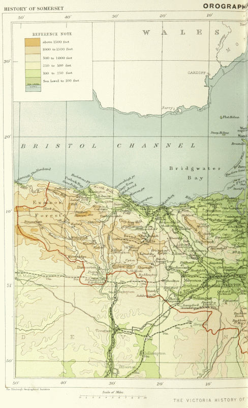
Orographical Map
Knolls like Glastonbury Tor and Brent Knoll are striking monuments of denudation. Others near Ilminster, Montacute, South Cadbury and Castle Cary, not far removed from the main escarpment, indicate how the severance of such outliers may take place. Subterranean drainage and erosion in the first instance lead to the formation of underground channels in the impervious Lias clays beneath the porous Midford Sands and the limestones of the Inferior Oolite. The limestones themselves may be in part wasted by chemical dissolution, and if channels are formed in subjacent strata slight subsidences must take place here and there, and pave the way for the disconnection of portions of the main limestones to form outliers. The subsequent more complete isolation of the severed masses is due to the superficial and subterranean erosion by rain and streams. In the case of Brent Knoll and Glastonbury Tor the influence of estuarine waters that once spread over the Somerset levels must have helped to complete the denudation. The slightly basin-shaped arrangement of the strata in both these outliers has helped in their preservation. The effects of subterranean erosion are also seen where valley gravel rests on furrowed surfaces of clays such as those of the Lias near Bath.
Elsewhere along the Mendip plateau and that of Broadfield Down the effects of chemical as well as mechanical erosion are evident in the deep ravines and caverns. A few of the ravines may have been initiated in the Triassic period, and have been re-excavated and deepened in later times, but Cheddar, Ebbor, Burrington, Brockley and Cleeve and most others probably belong in the main to the post-Pliocene period. Many of the great fissures on Mendip originating along joint planes or lines of fracture have been so enlarged as to form a series of caverns, and in some cases where erosion has proceeded further a deep ravine has resulted. The solvent action of carbonated water, aided by frost and streams, mainly contributed to produce the effect.
In the case of Cheddar the dip has exercised much influence on the shape of the cliffs, the one side with the inward dip standing up boldly and precipitously, while the other, the dip slope, affording abundant evidence of disintegration, showers of detritus now and then falling on to the road and in old times into a deep natural gully. The cliffs are perhaps the finest of their kind in England, and they rise at one point to a height of 420 feet above the level of the road.
Several of the streams which issue at the foot of the Mendip Hills take their rise from swallet holes in the Carboniferous Limestone of the plateau. Among these are St. Andrew's and other springs at Wells, the Axe (derived from Priddy) which issues at Wookey Hole, and the Cheddar water.
These waters flowing through limestone areas carry away much carbonate of lime in solution, but under certain conditions they redeposit it on the roofs and floors of caverns in the form of stalactites and stalagmites, or elsewhere in pipes; and in some instances, as near Coleford, Darshill near Shepton Mallet, and Chilton-upon-Polden, there are deposits of tufa left by petrifying springs.
While the Avon was cutting its rocky course the area of the Bristol Channel was evidently a great vale of Lias which spread from Watchet to the Glamorganshire coast, while the Inferior Oolite of Dundry and and the Midford Sands of Brent Knoll were connected with the main escarpments. This broad vale was trenched by the Severn drainage and afterwards widened by estuarine and marine action. The plain of marine erosion is now well seen in the wide rocky platform which is exposed at low tide at Watchet, but the sea must in Pleistocene times have cut its way up to some of the Limestone cliffs near Weston-super-Mare, as there we find traces of raised beaches.
In this brief sketch no reference has been made to the Glacial period, prior to which the main features throughout England were produced. Evidences of the Great Ice Age in Somerset are few and local. Unlike many other areas it was not buried beneath a mantle of ice, nor overspread with deposits of boulder clay or drift gravel. For this reason the soils of Somerset are for the most part local, bearing a direct relation to the sub-strata. No doubt the area has been affected by Pleistocene climatic changes and fluctuations in level, but from later Tertiary until comparatively recent times it has been subject chiefly to waste by rain, rivers and sea rather than to deposit.
The striated surfaces of Devonian sandstone observed near Porlock by W. C. Lucy, and the 'terminal curvature' of the slaty rocks near Wiveliscombe noted by D. Mackintosh, (fn. 41) are features which may have been produced by local agents.
Relics of early stages in denudation are met with in the shape of chalk flints, and pebbles of quartz and quartzite, which have been found here and there on the surface and in chinks of the Oolites on Farley, Bathampton and Claverton Downs. Small patches of gravel have also been observed on Clevedon Down.
Valley gravels here and there fringe the rivers and occur in scattered patches in the vales, but the only extensive superficial deposits are those which occupy the alluvial moorlands.
Along the Avon valley there are here and there small areas of river gravel, and these have yielded in places remains of Pleistocene mammalia such as we find in the older deposits of the Thames valley. These include mammoth or Elephas primigenius, also E. antiquus, rhinoceros, musk ox and reindeer. (fn. 42) Thus at Freshford, Bathampton, Bath and Keynsham there are deposits of gravel made up of local materials, the limestones of the Lias and Oolites, together with harder materials of the Carboniferous group and Old Red Sandstone derived from tributary streams which rise in the Mendips. At Larkhall, Bath, as much as 30 feet of gravel and loamy beds have been observed.
Valley gravel occurs at Wells and Wookey, along the Brue valley near Bruton and Castle Cary, and over the Lias vale bordering the rivers Yeo and Cary near Ilchester and Langport, at Babcary, Milton, Puddimore and other places. Patches of clayey gravel largely composed of chert detritus from the Greensand hills occur from near Chard to Broadway, at Ashill and other places.
At Taunton the valley gravel has yielded rhinoceros and Irish elk, as well as remains of alder, ash and oak timber; and in this neighbourhood one Palæolithic implement was obtained by W. Bidgood. In the vale extending to Williton there are patches of gravel largely derived from the New Red conglomerates.
Possibly of the same age as some of the valley gravels into which they may have merged, are the remnants of raised beaches made up mainly of Carboniferous Limestone pebbles with occasional flints, and preserved on platforms of the limestone at Anchor Head and Woodspring Hill north of Weston-super-Mare. (fn. 43) They lie from 20 to 30 feet above high-water mark, and are covered by blown sand, by rubble or talus of ancient date, and by recent talus. The beaches yield Mytilus edulis, Cardium edule, Tellina balthica, Ostrea edulis, Buccinum undatum and Littorina littorea. All these species and others such as Scrobicularia are found in the so-called Burtle Beds. These comprise sands with occasional pebbles, sometimes cemented into hard bands, which occur in patches on the Lias or Red Marl in the moorlands at Burtle between Glastonbury and Highbridge, and at Middlezoy and Chedzoy near Bridgewater. Whether these Burtle Beds were contemporaneous with the raised beaches or were due to later incursions of the sea over the low lands is not certain.
The older rubble drift above the raised beaches has yielded remains of hyæna, bear, mammoth and rhinoceros. Hence these deposits may be compared with some of the valley gravels, with the older cave deposits, and with bone fissures such as occur on the Oolitic hills near Bath, where remains of rhinoceros, bison and lemming have been obtained. It must be remembered however that the Pleistocene period was a long one and attended by considerable physical changes, and that in South Wales Mr. R. H. Tiddeman has pointed out that subsequent to the raised beaches and the infilling of some of the caverns in Gower the local boulder drift was accumulated. (fn. 44)
Many caverns occur in Somerset, the more noteworthy being those of Cheddar, which contain fine stalactites, Wookey Hole, Burrington, Banwell and Uphill. (fn. 45) The Lamb Cavern near East Harptree is an extensive one, in which formerly there were lead workings.
The hyæna den of Wookey Hole, worked out by Professor W. Boyd Dawkins, is a fissure in the Dolomitic Conglomerate distinct from the large cavern in the Carboniferous Limestone. It has yielded remains of hyæna, cave lion, bear, badger, mammoth, rhinoceros, Irish elk, etc., together with implements of flint and chert of somewhat rude workmanship. Many of the bones bear evidence of having been gnawed by hyænas. Professor Dawkins expressed the opinion that at the time of the occupation of these caves a great plain extended over much of what is now the Bristol Channel. The land must indeed have stood higher previous to the accumulation of the more recent alluvial deposits, probably to the extent of 50 or 60 feet. Proof of this is to be gathered from the depth of these more recent deposits, and from the evidences of old forest growth at their base at Porlock (fn. 46) and elsewhere. The marshlands as near Bridgewater are made up of a succession of fluviatile and estuarine mud deposits, gravel and sand, and peat, with evidence of plant growth at more than one horizon. Remains of an old forest at Stolford were long ago recognized. Occasionally the peat is found in a compressed and indurated condition known locally as pill coal.
Peat is extensively dug to a depth of 14 or 15 feet on the moors between Glastonbury and Highbridge, especially near Ashcot, Shapwick and Edington. It is largely composed of the common sedge, bog moss, reeds and rushes.
The alluvial deposits have yielded remains of existing land and freshwater mollusca, and of such animals as Bos taurus var. longifrons, roe deer, goat, sheep, horse and dog.
The estuary of the Severn is noted for the extensive mud flats bordering it at low tide, and which are liable, as near the mouth of the Parret, to constant changes. The turmoil of the tidal waters agitates this silty material, and Weston-super-Mare has gained the name of 'Weston-super-Mud' from the fact that at low tide there is an extensive area of sandy silt and the waters are clouded with the suspended matter. This is borne down to a large extent by the rivers which drain into the Severn Sea, but is partly derived from the waste of the cliffs. (fn. 47)
At Bridgewater the material is utilized in the formation of the celebrated scouring bricks, named Bath bricks from the original manuturer, Mr. Bath. Tanks or slime-batches have been constructed on the borders of the Parret, into which the tidal waters are admitted and the slime is allowed to subside. This slime contains about 70 per cent of fine siliceous matter.
The marshlands over considerable areas lie beneath high water level, in some places as much as 8 or 10 feet, but they have since Roman times been more or less protected by artificial embankments, while the dunes of blown sand between Burnham and Woodspring, north of Weston-super-Mare, have likewise checked the inflow of the sea. The rivers too have been embanked and their courses have locally been modified, but in times of long continued heavy rain the dykes and sluggish rivers are unable to carry off the land drainage which is held up by the tidal waters; and from these causes and the occasional bursting of a bank or overflow of a stream the marshes are sometimes inundated for many square miles. (fn. 48) The fine silty material then deposited helps to fertilize these large areas of dairy and grazing ground. In times of flood Athelney, a low hill which rises from the alluvial moors between Langport and Bridgewater, is liable to become an island; but Glastonbury Tor, the Isle of Avalon, has probably never been surrounded by water in the historic period, though situated in the midst of marshes and bogs.
In ancient times the uplands were extensively wooded, and remains of the Mendip forest above Wells and Cheddar, of Selwood forest which stretched from Frome to Wincanton, and of the forests of North Petherton, Neroche and Exmoor which occupied much of southern and western Somerset were long unenclosed, some portions until the middle of the eighteenth century. The most prominent heights were early fortified, and the history of these earthworks and of the still older lake dwellings near Glastonbury link geology with human history. Indeed since Roman times some geological changes have taken place, and alluvium and peaty beds have been accumulated to a depth of 12 feet at Bath and on the levels of Burnham and Huntspill.