A History of the County of Somerset: Volume 1. Originally published by Victoria County History, London, 1906.
This free content was digitised by double rekeying. All rights reserved.
'Romano-British Somerset: Part 3, Other Locations', in A History of the County of Somerset: Volume 1, ed. William Page (London, 1906), British History Online https://www.british-history.ac.uk/vch/som/vol1/pp289-356 [accessed 30 April 2025].
'Romano-British Somerset: Part 3, Other Locations', in A History of the County of Somerset: Volume 1. Edited by William Page (London, 1906), British History Online, accessed April 30, 2025, https://www.british-history.ac.uk/vch/som/vol1/pp289-356.
"Romano-British Somerset: Part 3, Other Locations". A History of the County of Somerset: Volume 1. Ed. William Page (London, 1906), British History Online. Web. 30 April 2025. https://www.british-history.ac.uk/vch/som/vol1/pp289-356.
In this section
PART III.
1. CAMERTON
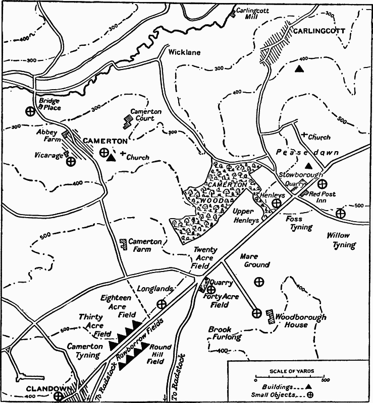
Fig. 56. Plan of the Neighbourhood of Camerton.
About six miles south of Bath the Fosse Way runs for more than two miles along a lofty plateau just 500 ft. above sea-level, which divides the Dunkerton and Radstock valleys. On the southern edge of this plateau, immediately above Radstock and close to the hamlet of Clandown, in the parish of Camerton, is a spot beside the Roman road which has yielded remarkable remains (fig. 56). It is first mentioned, as it seems, by Collinson about 1790, who records briefly a tessellated pavement and coins (fn. 1) in this neighbourhood. It was explored in 1814 and succeeding years by the Rev. John Skinner, rector of Camerton from 1800 to 1839. It is still marked by Roman potsherds and tiles that lie about the fields, as I found when I visited the spot. But substantially all that we know of it is due to Skinner, and is contained in his papers and diaries. Skinner was an enthusiastic and industrious worker. But he seems to have been impulsive and unmethodical; he had received no proper archaeological training, and his imagination not seldom ran away with his natural powers of observation. It is therefore difficult to extract from his materials any precise account of his finds, or to deduce any certain estimate of their significance. It would seem, however, that he discovered parts of a small village, and possibly also a local shrine which was regarded as holy both before and during the Roman period. (fn. 2) (fn. 3)
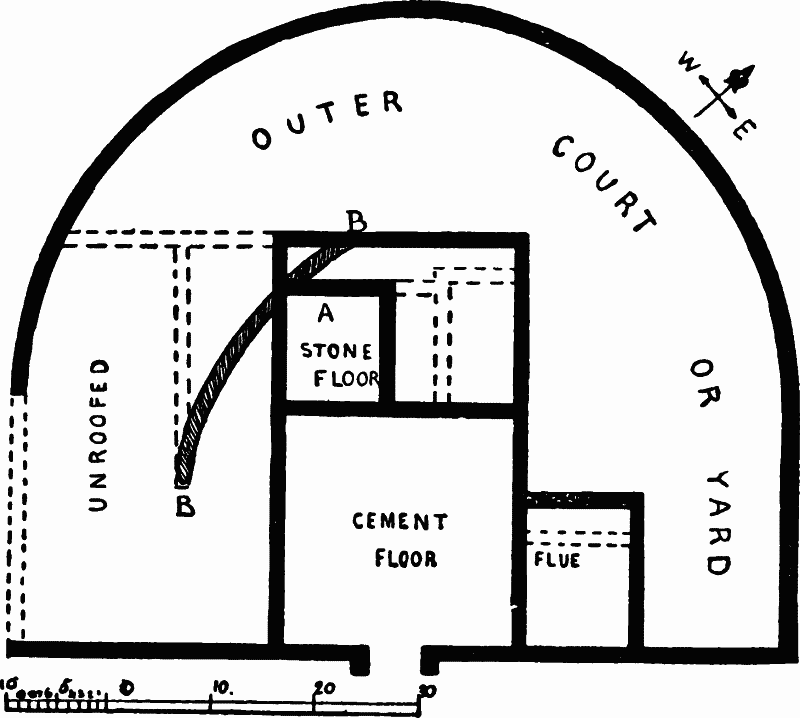
Fig. 57. Plan of Larger House, excavated 1814–5. (From Skinner.)
The chief scene of his labours was in some fields beside the Fosse, north-east of Clandown, near the Round Hill tumulus. These fields were and still are called Thirty Acre Field, Eighteen Acre Field (these two now one field), and Longlands, on the north side of the Fosse, and Rowbarrow on the south side. The principal finds were made in Eighteen Acre Field. In total they consisted of a very uncertain number of small houses or other buildings, estimated by Skinner at eighteen, and many interesting lesser objects. The largest house, excavated in 1814–5, faced the Fosse, standing about 150 feet north of it, and contained five rooms and a semicircular open yard, of which the outline can best be gathered from fig. 57. It is not a normal outline, or one to which I can quote any precise parallel, though a building outside the Saalburg is somewhat similar. Nor can we now ascertain how far it is exact, for when the excavation was completed, the greater part of the walling was led away by Mr. Skinner or the farmer of the land as building material. More important are the smaller finds. The little 9 ft. room, marked A on the plan, yielded the lower part of a broken inscription; part of a freestone statuette 12 inches high; a pedestal with the feet of two adults and two children; a stone spear-head 5½ inches long; the capital of a freestone column 20 inches in diameter, and some painted stucco. The inscription is a bit of white lias, 7 inches long by 2½ inches high. It reads, so far as intelligible, in letters 5/8; inch high (fig. 73).
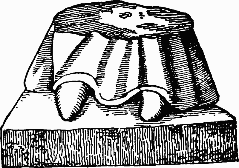
Fig. 58. Base of Statuette.
ΛIIVS
cONDEDIT
Severo ETQVINTIANO COS
'Set up (by some one whose name is lost but perhaps ended in —anus) in the consulship of Severus and Quintianus,' a.d. 235. (fn. 4)
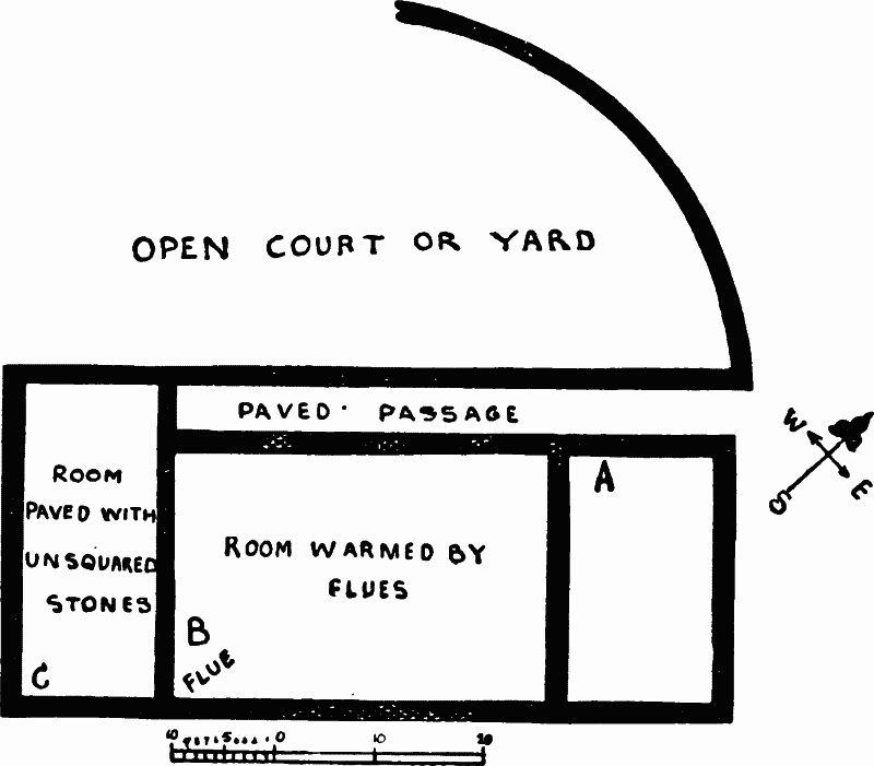
Fig. 59. Plan of Smaller House, Excavated 1817. (From Skinner.)
The statuette and stone spear-head suggested to Skinner the theory of a figure of Minerva with her spear. The pieces unfortunately do not fit in size, but the notion that we have here the vestiges of a local shrine is not impossible. Other discoveries, made in one part or other of the building, include Samian, some stamped CLVPPIM (or GL—) and OF SECVN, some embossed in second century style, a specimen of New Forest ware, a British coin and issues of Vespasian, Marcus, Tetricus, and Constantine, many fibulae, some glass, a leaden bracelet with a snake's head on it (an Italian device), a quern and many roof-slabs with nails.
A second and smaller house was found in 1817 about 50 feet west or north-west of the first, and about 200 feet from the line of the Fosse Way. Here also we find rooms and a circular yard, but the yard now lies wholly behind and not around the building (fig. 59). The finds made in this house show that it was intended to be warmed and inhabited, and its outline bears some relation to that of a corridor house. The principal objects found here were a bit of lead ore, 4 lb. in weight, much Samian and other pottery, including a thumb-vase, fibulae, bones, an iron lampstand (?), and three hoards of coins, all buried apparently just before the end of the third century. At the point A on the plan, 60 third brass were unearthed, dating from Gallienus, Valerian, Victorinus, Tetricus, Claudius Gothicus, Carausius and Allectus. At B, near or under the 'flue' which warmed the room, 114 third brass were found 'deposited in a small trench'; many were of Gallienus, Probus and Tacitus, a few of Claudius Gothicus, Quintillus, Aurelian, one of Carausius. At C a larger hoard of 334 coins was extracted from below two large stones, placed (as it seemed) purposely above it: the coins were of Gallienus, Probus, Tacitus and Claudius Gothicus.
Traces of other buildings were excavated to the south and west of the two just described, both in Eighteen Acre and in Thirty Acre Field, and others eastwards in Longlands, and Mr. Skinner estimated ten habitations in all on this side of the Fosse. But no definite remains could be made out. Broken walls, coarse pavements, flat-headed nails, roof-slates, coins and the like were found freely but no continuous walls or intelligible houses. Equally obscure were remains taken by Mr. Skinner to represent six small cottages, or the like, in Rowbarrow Field on the opposite side of the Fosse. Here he thought that he detected 'a connected line of habitations of artificers; there being a number of flues and pieces of iron and lead ore found amongst the rubbish. also sepulchral urns let into the ground, within the walls of the houses. There were the remains of terras (cemented) floors to some of the houses, and fragments of painted stucco, red, yellow and green. Some of the foundation walls of these buildings were found under the road now called the Fosse.' (fn. 5) Samian was also found inscribed ALBVCIANI and SACIRO and a pelvis marked SBI on the lip, probably the same as a piece now in the Bristol Museum which seems to read [symbol]SB[symbol].
Of miscellaneous remains found in one part or another of this settlement, coins were the most abundant. They cover all periods. Two British ones occurred in Eighteen Acre Field; other early issues are of Augustus, Agrippa, Drusus, Claudius, and Nero (1 each), Vespasian (6), Titus (4). Many belonged to the Constantinian family, and the series of those found up to 1818 ends with 2 Magnus Maximus, 7 Theodosius, 7 Arcadius and 8 Honorius. (fn. 6) Potsherds—Samian and coarser ware— abounded to the extent of 'bushels of every description,' and among the potters' stamps were V✝ALIS, OFLCVIRIL, OFCELI, DRVCVRSV, MARTIIO, CLAIIIIAE, CORNOI, ORPARRNT, IIIIXORI and ACVMR/S, these last perhaps misread. Much window and bottle glass, 40 fibulae, 7 spoons, 3 keys, 12 styles, many other iron and bronze pieces of various kinds, bone instruments, jet, two blue-stones, one with a dolphin and one with 'eastern characters' (possibly Abraxas), and so forth, are also recorded. In general the remains, as known to us by the copious sketches of Skinner, both attest by their number a fair-sized village and illustrate by their Roman character the general dominion of Roman culture in Britain. But especial interest attaches to a bronze object of Late Celtic design found in Eighteen Acre Field. (fn. 7) It may well be of earlier date, than the Roman conquest (fig. 61). A similar object, but of Roman style and date, has been found at Novaesium (Neuss).
Fig. 60. Fibula shewing Celtic Affinities. Found in Eighteen Acre Field (Skinner, Add. MS. 33661, fol. 142. From the original in the Bristol Museum (1/1).
Fig. 61. Bronze Piece of Late Celtic Work (1/1), (From the original in the Bristol Museum.)
The Roman remains of Camerton lie thickest in the area which we have just been considering. But if Mr. Skinner is correct, they extend widely beyond its limits. Much was noted by him further north-east on the line of the Fosse, and in particular in Stowborough Field, opposite the Red Post Inn, better known in coaching days than now. (fn. 8) Here foundations, coins, pottery (including Samian stamped CAIVS.), and graves dug in the rock were observed, and a silver coin of Vespasian was picked up close by. To the north, in Camerton village, coins (including a Tetricus, a Constantius, and a Constantine), potsherds, iron arrowheads, and a small bronze figurine of Vesta were noted. To the east, under Eckwick Hill on Oldbury, coins, potsherds and 'foundations of several houses' were recorded, and much the same was seen in Underdown Field on White Oxmead Farm. To the west near Clandown, in a field called Great Stanley's, 'foundations and roofing stones,' from local quarries were seen scattered over the surface, and ploughmen picked up coins and pottery, and further on two buildings, probably the residence and outhouses of a villa, were noted in the direction of Paulton (p. 315).
The general impression made by Mr. Skinner's list is that he saw Roman foundations everywhere. But this impression is perhaps a little unjust. A critical survey of his statements suggests rather that a loosely settled village did exist in Roman times on the Fosse Way near Clandown. The nucleus of this village was near Eighteen Acre Field, where (as we have said) there was possibly the shrine of some local god or goddess. But its houses may have been spread over a considerable area, (fn. 9) and some at least of Mr. Skinner's Roman masonry may be genuine vestiges of it. The period of this village is indicated fairly well by coins. It begins before or at the very opening of the Roman period. It ends only with the end of things Romano-British. During these four centuries the civilization of the site is predominantly Roman. A few objects suggest Celtic influences. In general we see that predominance of Roman fashions and Roman conventionality which marks the whole or almost the whole of Romano-British civilization.
2. ILCHESTER
Ilchester lies beside the river Yeo, in the centre of the broad, low expanse which intervenes between the higher lands near Somerton, Yeovil and Castle Cary. The marsh comes up to its western edge and the neighbourhood is liable to flood. But it occupies a central position and commands a crossing of the river, and hence at least in mediaeval times, it possessed some real importance. This importance has coloured the views generally held of its character in the Roman period. It was thought by early archaeologists, such as Camden, Gerard and Stukeley, to have been a large Roman town. But our survey will show that it more probably was what it is to-day, a poor and unimportant village, situated where the Fosse Way threw out a branch to Dorchester.
The remains actually recorded are few. Camden mentions coins, Gerard adds foundations, and emphasizes the preponderance of fourth century coins. (fn. 10) Stukeley visited the place himself and gives a much fuller account. He thought that he saw an enclosure with walls and ditches, measuring 200 by 300 paces. But these seem to be either mediaeval or imaginary. More solid finds which he records are brick and tessellated pavement, tiles, and coins, including one of Pius. (fn. 11) Later additions to this list are scanty. Another pavement was discovered in the grounds of Ivel House, Northover, in 1887, (fn. 12) and among smaller objects are a gold ring set with an aureus of Severus Alexander (fn. 13); a bronze ornament of a face, inlaid with silver, (fn. 14) a fibula, (fn. 15) and two indications of burials, one, part of a skull with a coin from the Manor Farm, and the other, part of a leaden coffin from Northover House. (fn. 16) This is a brief list, and it is all. (fn. 17) Of Phelps' prætorium, amphitheatre and equestrian camp there is no sign whatever. If the bridge over the Yeo is Roman, as it might possibly be in origin, there is no evidence to prove the fact. (fn. 18) No certain date can be assigned to the old causeway in the river, which is also said to be Roman, or to the earthworks mentioned by Buckler. (fn. 19) Even the enthusiastic Skinner, visiting the site in 1829, had to confess that hardly a vestige of the Roman occupation could be traced. (fn. 20) Here, we may be sure, stood no large Romano-British town.
Lastly, the name. Servetus in 1535 suggested Ischalis, or, as it should be spelt, Iscalis. He took this name from Ptolemy, and Camden and almost every one has since followed him. (fn. 21) Yet in reality little can be said for his view. In the first place Iscalis was only chosen because it began with the same letter as Ilchester. This similarity between the names is not great in itself, and etymologically it is delusive. For Ilchester was originally 'the Chester on the Ivel,' and that form of the river name appears in its ancient forms. For example, Florence of Worcester calls it Givelcaster, and others style it Ivelchester, which is a long way from Iscalis. And in the second place, Ptolemy is very likely here inaccurate. His name Iscalis may well be a confusion between Isca Silurum and Isca Dumnoniorum, as several scholars have conjectured. We must therefore be content to assign to Ilchester no Roman name.
3. HAM HILL
Ham or Hamdon Hill (fig. 62), forms the north-western extremity and almost the highest point in the irregular upland which rises three or four miles west of Yeovil. Jutting out from the main mass of this high ground, towering nearly 300 feet above the neighbouring plain of Martock, and fenced around three sides by a precipitous escarpment, its position is strong and stately beyond any in Somerset. Naturally it has been occupied from the earliest times. Round its summit runs a ring of huge entrenchments three miles in length, defending an area of 200 acres. Within this enclosure antiquities of many periods have come to light: Neolithic, Bronze Age, Celtic, and lastly Roman. Most of these have been discovered near the western face of the hill in the course of quarrying the Ham stone, with which innumerable Somerset churches and houses have been built. The Roman remains belong principally to a triangular peninsula which springs out at the north end of this western face. Unfortunately no record has been kept of the circumstances under which the different discoveries were made. Quarrymen have unearthed them in the course of their work, and local collectors, especially the late Mr. W. W. Walter, of Stoke-under-Ham, have preserved them. But neither quarrymen nor collectors have adequately described the finds, and the detached and individual objects do not of themselves unfold the story of the hill. (fn. 22)
Plainly, however, the site was occupied in British and Roman times. Of Celtic remains assignable to a pre-Roman period we have such striking instances as pottery similar to that of the Glastonbury lake-village (figs. 3 and 63), a small bronze head of a bull (fig. 63, 12), an uninscribed British bronze coin, a comb, bits of a chariot wheel and weapons, and some of those iron bars resembling unfinished swords, which may perhaps be specimens of the iron coinage of the Britons mentioned by Caesar. (fn. 23)
Roman remains are more plentiful, and no less interesting. Among the bronze objects are some 38 scales, 1 inch in length, and 9/16 inch in width, belonging to a breastplate. They are tinned alternately for decorative purposes, connected by tiny wire rings, and provided with holes by which they could be sewn on to a leather bodice. Similar pieces of scale armour have been found at many places in Britain—Hod Hill, Colchester, Catterick Bridge, Walltown and Great Chesters on Hadrian's Wall, Newstead near Melrose—and various sites abroad. (fn. 24) Other bronze objects are a dozen or more bow fibulae, including two uninscribed 'Aucissa' specimens, and one inscribed AVCI[symbol][symbol]A (see p. 343), a few penannular brooches, rings, buckles, a bell, a lamp found in 1848, and a bit of thin répoussé work of Late Celtic affinities and possibly of pre-Roman date (fig. 63, 4). Iron is also frequent in the shape of keys, knives, nails, chains, and the like; the age of these, however, is not always certain. Various small objects in bone, including a die (fig. 63, 8), fragments of glass, a clay sling-bullet (fig. 63, 9), spindlewhorls, a few Samian potsherds including one stamped inside the base ERTIVSF, Tertius fecit, and many specimens of plainer grey ware, have also been preserved.
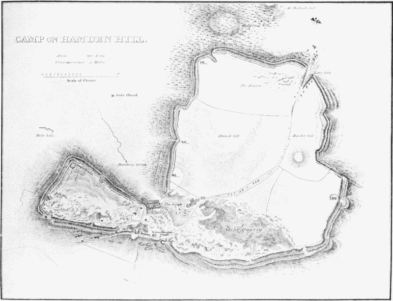
Fig. 62. Plan of Ham Hill. (From Archæologia.)
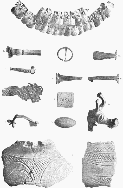
Fig. 63. Remains from Ham Hill, in Taunton Museum. (From Photographs by Mr. Gray.) 1. Scale armour (2/3). 2, 3, 5, 6, 7, 10, 11. Fibulae. 4. Thin Repoussé Bronze of Late Celtic Style. 8. Roman Die. 9. Clay Slingbullet. 12. Bronze Head, Late Celtic. 13. Potsherds (resembling those of Glastonbury, fig. 3).
The recorded coins extend over all the first four centuries of our era from Augustus to Theodosius I, and are numerous. But in this point appearances may be deceitful. Unfortunately, those who have preserved them have not distinguished between coins discovered sporadically on the hill and coins found in two large hoards. Of these hoards, the most notable was discovered in 1882 at Bedmoor or Batemoor Barn, a site in Montacute parish just outside the southeast corner of the camp, at the point where a lane ascending from Montacute reaches the plateau. The hoard was contained in three good-sized amphorae. One of these, now at Taunton, is a large eggshaped jar of coarse buff ware, about 11 inches high, with two very small handles. The coins are said to have numbered over 2,000, and to have consisted of Large Brass. No proper list was ever made, and most of them passed unregistered into collections in which they cannot now be distinguished. But Mr. C. R. Smith records 293, all much worn except the latest, a coin of Philip.
10 Domitian
4 Nerva
40 Trajan
133 Hadrian
2 Sabina
1 Aelius
35 Pius
18 Faustina sen.
25 Marcus
16 Faustina jun.
3 Lucius Verus
2 Lucilla
2 Commodus
1 Crispina
1 Philip
To these Mr. Franklin adds a First Brass of Severus Alexander, Mr. Norris had second century First Brass from Hadrian to Commodus, now at Taunton; and Mr. Phelips of Montacute has coins of Augustus, Trajan and his successors to Albinus, Julia Mamaea, Severus Alexander and Postumus, which, or some of which, are said to come from this hoard. It would seem that the hoard was wholly of First Brass, and buried about the middle of the third century. (fn. 25) A second hoard was dug up about 1816 at some little distance south of Ham Hill. It was contained in a large earthen vase, and comprised coins of copper and white metal, many of them probably cast in moulds, from Volusian to Constantine (251–337), or according to another account from Aquilia Severa to Tetricus (220–272). (fn. 26)
It can hardly be doubted that, besides these two hoards, many coins have been discovered sporadically in the camp. But the indifference of finders, and perhaps even of collectors, has left us unable to distinguish such sporadic finds. We have a few statements that indicate their occurrence. But records of definite coins, found on Ham Hill and yet certainly different from the hoards just mentioned, are fewer than might be expected. We have therefore to rely on the general probability of such sporadic finds, and on the vague statements of our authorities, if we assert that coins have occurred not infrequently in the camp. (fn. 27)
After all, however, the character of the occupation remains obscure. Here, as at Hod Hill in Dorset and Borough Hill in Northampton shire, men of the Roman period occupied an earlier site. But here their remains, however interesting, are comparatively few, and they lack indications of luxury. The scale armour may have been lost in the early years of the Roman conquest, when troops were pacifying southern Britain and constructing the Fosse to Exeter. The rest of the inhabitation may have been a survival from British days, or, in later times, a village of quarrymen working the excellent building stone, which was even then well known and used.
4. VILLAS AND RURAL DWELLINGS
From towns and villages we pass to the country outside them, and to the dwelling-houses of one sort or another which stood alone, or almost alone, scattered up and down the land.
Somerset is rich in such dwelling-houses. No less than 58 are known to us with more or less certainty and will be described below. Some of these are doubtful instances. But even when those are deducted, the total remains impressive. It is plain that Somerset was not a thinly inhabited or thinly civilized district in Roman days. But this conclusion is not true of the whole county. The Roman villas of Somerset occur almost wholly in its eastern half. Hardly a single example lies west of longitude 3°. Nor is this surprising. The marshes of West Somerset and its hills, Quantock and Exmoor, are ill adapted to a country population. Even the pleasant little vale of Taunton Deane lay too remote from roads, and too exposed, it may be, to the hill tribes and the Irish pirates to form a centre of rich and peaceful life. We find at Taunton some traces which suggest a village (p. 367). But, apart from this, the vale is almost as empty of remains as the very hills and marshes.
Within East Somerset we may group our 58 villas, at least for convenience, into five main divisions. These are (1) the villas near the Avon and the north-east edge of the county; (2) those in or near the Vale of Wrington and the basin of the northern Yeo; (3) those near and east of the Fosse between Bath and Ilchester; (4) a large series planted mostly on the irregular sweep of high land which runs round the marshes of the Parrett and the Carey, past Langport, Somerton, Street, and the Polden hills; and lastly (5) the villas in the extreme south, near South Petherton, Yeovil, and Chard.
Very few of these dwelling-houses have been excavated at all completely, and of many we know so little that we cannot feel sure of their exact character. Still it may be worth while to attempt—what has never been attempted as yet—to summarize and tabulate the chief recorded discoveries. Thus only can a reader gain some faint conception of this vanished rural civilization, with its country-houses and farms, its hamlets and its isolated cottages. Many of the houses, we shall find, were large and luxurious, though none of them rank in the very first class of Romano-British villas with Bignor and Chedworth and Woodchester. Others, again, were small and insignificant, and rather farmsteads than the residences of wealthy and highly civilized owners. In ground plan, so far as we know, they were normal. The two ordinary types, courtyard and corridor (p. 213), occur freely. Once only, at Yatton, does a distinct and different form of house seem to intrude (No. 11). The mosaics, again, appear to be normal. Their figures and their geometrical designs are often artistically good. But only one scene (No. 50) is really remarkable in subject, while of a local fashion, such as appears in Northamptonshire, (fn. 28) we meet hardly a trace (No. 19). One interesting piece of evidence is, however, supplied by these villas. Several have yielded Roman inscriptions, and one of these is a graffito on a potsherd (No. 23). This would seem to prove that even in the west of Britain the inhabitants of these houses used Latin, and the scratched potsherd suggests that this knowledge was not confined to the upper classes.
Some conclusions may also be drawn from the coins which have been recorded as discovered in these villas. Our lists of such coins are doubtless incomplete. Here, as elsewhere, we must allow for finds that have been forgotten and finds that have yet to be made. But in about two dozen cases we chance to possess fairly full accounts, such as may be used provisionally for historical purposes. They may form a basis for conjectures as to the periods when the Somersetshire villas were first built, were inhabited and were finally abandoned. It is, I fear, not easy to say when the settled life of the country districts began. Early coins are naturally rare in houses that have been continuously inhabited in after ages, and the absence of early coins is therefore not a conclusive proof that the house was built at a late period. Nor on the other hand is the occurrence of one or two early coins altogether decisive, since a few such issues lingered on in circulation long after their minting. The silver legionary coins of Mark Antony, for example, are known to have been current 100 or 200 years after his death. In the present case nine sites, Combe Down, Banwell, Chew Stoke, Paulton, Shepton, Chesterblade, Stanchester near Drayton, Coker and Wadeford have yielded coins of the first or second centuries, and these, or some of these, may have been occupied by a.d. 150 or earlier. On the other hand fourteen sites—Farley, Lansdown, Newton, Brislington, Long Ashton, Yatton, Wellow, Ditcheat, Street, Littleton, High Ham, Drayton and Chard contribute only third and fourth century issues, and those mostly later than a.d. 250. But after about 250 a.d., coins are commoner. Almost every villa yields specimens of the years a.d. 270–350. This is the period which must have seen the greatest extension and prosperity of Romano-British rural life and then, we may think, the villas were most definitely occupied. This conclusion is what we might expect on other grounds. The period in question was, as we chance to know from various evidence, a fragment of a happy age for Britain. It can be no accident that the farms and country houses of the province were then most numerous and, as it seems, most fully inhabited. It is, however, less easy to decide how long the occupation lasted. Ten sites were plainly inhabited till near the end of the fourth century—Lansdown, Newton, Combe Down, Shepton, Wellow, Chesterblade, Somerton, Coker, Chard and Wadeford. Others show no evidence of life later than a.d. 350–360—such as Farley, Brislington, Yatton, Banwell, Wellow, Ditcheat and Drayton. This may be due to the imperfection of our records. But it can be otherwise explained. The middle of the fourth century is the period when Saxon, Celt and Scot first became generally formidable to Britain. Perhaps it is no accident that country houses, even in remote Somerset, began, as it seems, to be burnt or abandoned about that date.
I. THE VALLEY OF THE AVON AND THE NORTH-EAST OF SOMERSET (1–11).
(1) Farley Hungerford. A Roman villa has been found in Temple Field half a mile north of Farley Hungerford near the farm road to Iford, 250 yards from the river Frome and close to the boundary of Hinton parish. It was partly excavated by the Rev. John Skinner of Camerton in 1822, and was reopened between 1850 and 1860. No plan of it seems to exist. It is described as a structure measuring 33 feet by 114 feet in extent, containing a well constructed bath and tessellated pavements. Coins of Tetricus, Magnentius and the Constantine family have been discovered here at one time or another. (fn. 29) This villa is to be distinguished from another which stood half a mile east of Farley, across the Avon and perhaps across the Wiltshire border, above Stowford on a site which I have not been able precisely to identify. (fn. 30)
There is no reason to suppose that a villa occupied the site of Farley Castle. A First Brass coin is said by Skinner to have been found there, but no other evidence exists of its inhabitation in Roman times.
(2, 3) Bathford. Two houses or buildings have been noted in this parish, both situated at the foot of Bathford Hill on the east bank of the Avon, but about half a mile apart.
One of these was found in 1691 or 1692 in a field called Horselands, between the church and the river, or, more precisely, about 100 yards below the Low House farmstead, near an ancient ford. The discovery is said to have consisted of a pavement 14 feet square, supported by a pillared hypocaust which, in its turn, seems to have stood on a mosaic floor. A spring of water was found beneath the building, and we may conjecture that the lower floor proved too damp and that another was, therefore, erected above it. Here perhaps, as in some other cases, the hypocaust may have served not for heating but for a dry basement Two altars and an urn of coins are said to have come to light about the same time. (fn. 31)
The second building stood in Mumford's or Mompas Mead, between Bathford and Warleigh, near the point where Wansdyke reaches the Avon. This has yielded an elaborate square capital of the Composite order, discovered in the eighteenth century, as well as a stone coffin and various tiles or pipes, found more recently. (fn. 32)
Other Roman remains have been recorded from the parish which may be connected with one or other of the preceding. In particular, the seventeenth century antiquary John Aubrey tells us that a mosaic floor was laid open by drainers in May 1655. It was, he says, worked in the usual white (chalk), blue (lias) and red (brick) : in the centre was a rudely figured bird and in each of the four corners a " sort of knot." Below it was a hypocaust with stone pillars and also a spring of water. The mosaic was destroyed by visitors : another mosaic was noted near it but not excavated. Aubrey does not give the site of this discovery, but we may obviously connect it with Horselands and suppose that the floor left untouched in 1655 was that opened in 1691. (fn. 33) In addition, Collinson records a coin of Allectus as found in the vicarage garden in his own day.
(4) Langridge. Traces of a villa are stated to have been found near Langridge Rectory on the eastern declivity of Lansdown looking eastwards over the valley towards Swanswick. Singularly little, however, is recorded about it. In fact the only definite finds seem to be two or three stone coffins found near the rectory. These supply no evidence of their date and need not necessarily be Roman. As traces of a villa are said to have been found, it is difficult to imagine that there was not a villa. But until we can learn what these traces comprised, we cannot repress a lurking doubt as to its existence. (fn. 34)
(5) Lansdown. Traces of a Roman building were excavated by the Rev. H. H. Winwood and others in the late summer of 1905 on the north side of Lansdown just within the Somerset boundary, near the Grenville monument, and immediately south of Battlefield House and grounds. The field in which the remains occur is steeply scarped on north and east and south, and the only easy approach is from the west. The remains include black soil, foundations of buildings, flagged floors, portions of columns and a female head in oolite, bricks and tiles, 59 coins ranging from Salonina to Valens (a.d. 253–378), many potsherds, but only a few pieces of Samian, fibulae—in particular, a circular disk-fibula enamelled in white and blue,—other bronze and iron fragments, some bits of glass, animals' bones, two rough-hewn stone coffins containing skeletons and iron nails, and some iron slag and ironstone. One fragment of grey ware, apparently the hough of a cup, has stamped on it inside, in the manner of a very rude Samian stamp, the letters XIMV. This may be borrowed from the name Maximus. But, as used here, it has probably no other object than to give the general idea of a potter's stamp. The exact character of the building does not seem clear. But it is probable that we have to do with some late 'villa.' The excavations are to be continued. (fn. 35)
(6) North Stoke. Just below North Stoke Church, and between it and the village, there was found in 1888, under a mediaeval barn belonging to the Manor farm, a building measuring 11 feet by 102 feet, with an apse at one end. Other walling was noticed quite close and also bricks and tiles and three bases and one capital of oolite (indicating shafts of 6½–7½ inches in diameter). The site was well chosen, for it is well watered and sheltered from the east and the north, and enjoys a good view over the west and south-west. A quarter of a mile east of the church on Little Down some interments were discovered in 1887: they included three skeletons, one in an oolite coffin with a few small nails. The Roman road—the so-called Via Julia—from Bath to Bitton and Sea Mills is supposed to have run close by, but a little lower down the hillside than the site of the villa. (fn. 36)
(7) Newton St. Loe. A Roman villa was brought to light here and partly uncovered about 1837, during the construction of the Great Western Railway from Bath to Bristol. It stood on ground that sloped gently towards the Avon, not far from the point where the Bath and Bristol road crosses the railway and on the south side of that road. Two distinct buildings were traced. One was lower down the slope than the other and was considered the more interesting. The portion of this which was excavated measured 55 feet by 102 feet, and consisted of a long corridor paved with mosaic, and rooms opening off it, some of which were provided with hypocausts. One of these rooms, in size 17 feet square, contained a figured mosaic in five colours—red (burnt brick), white and blue (local lias), brown (pennant grit), and green (lias marl from Bitton). Its subject was Orpheus seated within a central circle and surrounded by a circular series of beasts and trees. This was contained (as usual) in an oblong filled up with ordinary geometrical devices (lozenges, variations on the svastika pattern, etc.), noteworthy only for the patchwork fashion in which they are used (see No. 20, Wellow). Nichols states that the mosaics were found to be carefully covered up with slabs of stone to protect them, as if the last dwellers in the villa, when they abandoned it, still hoped one day to return and reoccupy it. Other mosaics were simpler. Smaller finds included painted wall plaster, window glass, tiles, potsherds, lead, nails and a few coins—1 silver Macrinus, bronze of Constans and Valentinian, 1 gold Honorius. Of the adjacent building nothing is recorded. It probably contained the servants' quarters and store rooms. Such second buildings are not rare in Roman villas (compare No. 22, Paulton). (fn. 37)
Burials have been detected in the neighbourhood of the villa. In 1869 quarrymen, working about a quarter of a mile away and nearer to Newton village, met with eight or nine interments, an urn with burnt bones, part of a wooden coffin with a 2-inch nail still in it, and also potsherds, coins of Probus and Constantine, and some bronze bits. More finds of the same character were made here during the next few years by Mr. Glover; the coins are said to have included ' Galba, Augustus, Pertinax, Constantine, Probus.' Finally in 1903, Mr. Falconer discovered more burnt bones, potsherds, a silver ring-key, a coin of Victorinus and some sandal nails. Some other burials have been found lately at Saltford, two miles to the north-west of Newton. But they can hardly be connected with this villa. (fn. 38)
(8) Burnett. At Burnett, in the parish of Corston and about halfway between that village and Marksbury, a Roman villa was discovered about 1830. A tessellated pavement and several small rooms, many potsherds and tiles, and, close by, two coins of Tetricus, have been recorded. An oolite coffin containing a woman's skeleton and iron nails (as of boots) near the feet, was found about 1890 in Lower Botmore Field in the same vicinity, and may possibly belong to one of the inhabitants of the house. (fn. 39)
(9) Brislington. A villa was discovered here in December 1899, during the construction of a new road close to the junction of Wick Lane and Bath Road. It was excavated at first by private efforts, and afterwards by the Bristol Museum Committee. The house was of the corridor type, facing south-west, and occupied an area of about 120 feet in length and 70 feet in depth (fig. 64). The walls were constructed of local stone: they were in parts much destroyed. Few, if any, traces of reconstruction or alteration were observed. Three apartments on the east side of the house, Nos. 1, 2, and the intervening passage, were floored with mosaics of conventional patterns—geometrical devices containing a cup or simple flowers—and probably the hypocaust and bath rooms (9, 10) at the other end of the building were similarly adorned. The central room, No. 5, had a flagged floor, a rubbish pit, and an open fire place. It was thought by the excavators to have been an open court, and, indeed, parallels can be cited for unroofed spaces in such a position, though they do not appear to be common in Romano-British villas. (fn. 40) Among the smaller finds are painted wallplaster; pennant roofing slabs; much pottery of the commoner sorts, though comparatively little Samian; bottle and window glass and glass beads; bronze pins and rings, and two bow fibulae; many iron objects, such as nails, tools, horseshoes; many broken bones of edible animals; a lump of yellow ochre; leaden weights, and a large tile eleven inches square, faintly scratched [symbol]H/ / /, or the like. Few coins were found, and those late and of copper (a.d. 267–361)—1 Victorinus, 1 Allectus, 1 Constantine the Great, 1 Constantinus II, 2 Constans, 3 Constantius II, and 1 illegible.
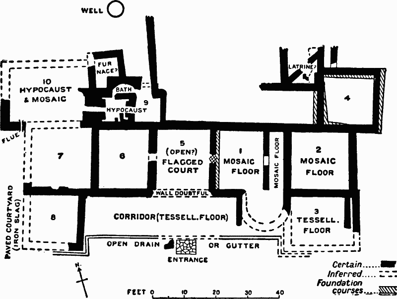
Fig. 64. Plan of Brislington Villa.
Notable objects were also taken out of the well, which was cleared to its full depth of 38 feet. Besides much indistinguishable rubbish, it yielded débris of building stone (at 24 and 36 feet), and tesserae (35 feet), a coin of Constantius II (14 feet), 4 skulls and other human bones (32 feet). Beneath these were 7 pewter vessels, more or less fragmentary, (fig. 65) and, at the bottom, bits of wooden buckets. The pewter vessels were of shapes not uncommon in the fourth century: their metal, when analysed, proved to contain lead (62.5), tin (36.0), and a tiny trace of antimony (0.8). The largest pewter jug has scratched underneath it VIIIS, probably 8½ ; a smaller jug has IIII, which may, however, be accidental. It is plain that the well at some time ceased to be used as a well, and was then filled with rubbish. The finding of building material in it suggests that this took place at the close of the history of the villa. Another interesting find was a considerable amount of iron slag and roasted ironstone, detected outside the west end of the house. This must not be taken to indicate any special industry in the modern sense of the phrase. We may think rather that those who dwelt here made iron objects for their own use, and perhaps also for their neighbours, though on a humble scale. I have failed to discover whence they obtained their ironstone; no deposits of this substance occur near Bristol.
As a whole, the remains found at the villa point to a late date and a comparatively brief existence. It may have been built about the end of the third century, and it was apparently abandoned soon after the middle of the fourth. The occurrence of burnt roof tiles and the like suggests that it was burnt down. (fn. 41)
(10) Long Ashton. When the Bristol and Exeter Railway was constructed in 1838–9, traces of Roman buildings were found in the deep cutting between Long Ashton and Flax Bourton, just at the point where the Bristol and Weston road crosses the line, and apparently near what is now called Cambridge Batch, 300 yards east of Bourton station. Here foundations, worked stone, including capitals, a steined well, two oak coffins, coins, potsherds, and bronze spoons were found in the railway works. The coins appear to have been principally of the third and early fourth century, reaching from Severus to the Constantine dynasty. Some subsequent excavations promoted by the Rev. George S. Master, of Bourton Grange, yielded only Samian and other potsherds. (fn. 42)
(11) Failand Hill. Mr. Skinner states that in 1819 he noticed Roman remains near Failand on the high ground north-west of Long Ashton—vestiges of buildings, dark soil, potsherds and coins, mostly Third Brass. These may perhaps be connected with the coins of the Lower Empire, massive foundations, and ' a military way leading towards Axbridge,' which Collinson records as found in Portbury parish. Col. Bramble has eight copper coins found long ago on Failand Hill— First Brass of Nero, Vespasian, Hadrian, Marcus, and Severus Alexander and Second Brass of Hadrian. The whole record is unsatisfactory, but it appears to point to some sort of house on Failand Hill. (fn. 43)
II. THE VALE OF WRINGTON AND ADJACENT DISTRICTS (12–18)
Fig. 65. Pewter Vessels found in the Well at Brislington, and Enlarged Sketches of the Patterns on them. (See p. 305.

Fig. 66. Plan of Roman Villa at Great Wemberham, near Yatton
(12) Yatton. A Roman villa was detected here and excavated in 1884. It lies to the west of Yatton, among the low marshes near the Yeo, in a large meadow called Wemberham. So close is the site to the river that the eastern end of the foundations abuts on the embankment, and so low does it lie that, without a sea wall, it would be flooded at most high tides. The embankment of the Yeo must, therefore, have been commenced in Roman times. The house itself is small, covering an area of 65 by 150 feet (fig. 66), but it is not devoid of comfort and elegance. In arrangement it differs from the normal types of Romano-British houses. If the published plans of it are correct, an entrance on the north side seems to have led into an outer and an inner hall, and these in turn gave access to rooms lying right and left, and to bathing apartments at the back. There is also a possible trace of a staircase leading to lofts or an upper story. The best rooms lay to the right or west of the entrance. One (A in the plan) was floored with an elaborate mosaic of foliated geometrical pattern in red, white and blue (fig. 67). This has been called Christian, as the central panel of foliation somewhat resembles a cross. The same feature however occurs elsewhere, (fn. 44) and appears to be merely ornamental. The room west of A had probably a similar floor, but it was too damaged to be reconstructed. A third mosaic adorned room B, a red, white and blue geometrical design, which when perfect may have had a central panel containing a two-handled cup or similar device. The rest of this wing of the house is known imperfectly, and is therefore not quite intelligible. At the back of the building were the baths, with some mosaic flooring. The left wing seems to have contained less well-furnished rooms. The two thick walls which run out from this wing towards the river are thought to have formed a boat-house and boat-channel, but no details of small objects or of silt and soil are recorded which either confirm or conflict with this idea. The smaller finds are of the ordinary kind—21 coins of a.d. 250–305 (or 360); potsherds, both Samian and other ; glass, iron and bone objects; painted wall plaster, bricks, tiles and roofing slates; and also some iron slag, less in amount, apparently, than that found at Brislington (No. 9). (fn. 45)
We may connect with this villa a discovery made in 1828 in the same field of Great Wemberham. This was a freestone coffin, shaped out of a solid block and very thick, with a stone lid, containing some fragments of a lead coffin and most of a human skeleton. We may also possibly connect a hoard found two miles away at Kingston Seymour. (fn. 46) For another possible house near Yatton, on Cadbury hill, see the Alphabetical Index under Yatton.
(13) Congresbury. About half a mile north-east of Congresbury village, at Woodlands, on the slope of Rhodyate Hill, traces of a small house or rural building have been noted. In 1867 Mr. White, then resident at Woodlands, uncovered two rooms, one with a hypocaust beneath it, and picked up abundant potsherds and other small objects, since lost. More recently Capt. Long, the present owner of Woodlands, has found pottery, including Samian and bronze implements, and has traced in the wood a boundary of loose stones enclosing several acres. One bit of Samian found here bears the mark RIIOGENI.M; one coin, found in 1873, is a Third Brass of the middle of the third century. The mass of potsherds found by Mr. White has suggested the idea of a potter's kiln, to which the subsoil is fairly suitable. (fn. 47)
(14) Banwell. Traces of a Roman ' villa ' have been noticed here in a field called Chapel Leases near the hamlet of Winthill, half a mile south of Banwell village, and on the south slope of Banwell Hill. The discoveries include foundations, bones and coins—1 large Brass of Severus Alexander found in 1813, and 1 silver of Julian found in 1801. To these we may probably add 1 Julius Caesar, 1 Trajan and 8 late Third Brass, which are preserved in Glastonbury Museum and labelled ' found at Banwell,' and a British silver coin and some Roman coins of the fourth century found at Banwell before 1852. A burial at Wolvershill, a mile and a half north of Banwell village, lies too far away to be connected with any certainty with the Winthill remains. The cruciform earthwork on Banwell Hill has, I think, no claim to be considered Roman. (fn. 48)
(15) Shipham. In the parish of Shipham extensive foundations were discovered long ago in a field to the north of the Star Inn, about ¼ mile north-west of the point where a Roman road—the so-called Via ad Axium (p. 350)—is said to cross the turnpike from Bristol to Bridgwater. No excavation was made, but numerous bricks and potsherds were picked up on the surface, and also a few coins, and some parched wheat, which was thought to indicate the destruction of the villa by fire. (fn. 49)
(16) Havyatt Green, Wrington. Two different records seem to indicate a villa here.
(1) The Gentleman's Magazine states that tiles and part of a blue and red border of a mosaic were uncovered in 1856 at Lower Langford in digging up the foundations of an old wall. (2) A correspondent of Mr. Skinner writes that in 1817 foundations and Samian and other potsherds were found in making a new road from Bristol to Bridgwater, at Havyatt Green, about half-way between Dolebury and Broadfield Down, Redhill. That is practically in Lower Langford village. Hence we may assume that the two finds belong to one and the same villa. The Lyehole villa (No. 17) is about a mile and a half distant. (fn. 50)
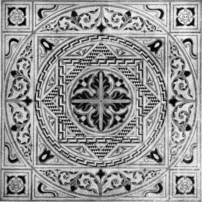
Fig. 67. Restoration of Mosaic found at the Wemberham Villa near Yatton (p. 306). (From Somerset Arch. Proc.)
(17) Lyehole, Wrington. At Lyehole, in the parish of Wrington, about two miles east of the village and two fields from the Lyehole farmhouse, in a pleasant and well-watered spot, traces of a villa were found and superficially examined in 1876. These traces were potsherds, bones, tiles, one or two tesserae from a pavement, wall plaster, a hypocaust in which the pilae were made in part with hexagonal rooftiles, and foundations covering half an acre. No coins or metal implement of any description, except a flat-headed nail, came to light. Abundant traces of charred wood and burning showed that the villa had been destroyed by fire. The villa at Havyatt Green (No. 16) is a mile and a half distant. An old deep lane, now disused, once led from the site of Lyehole villa towards Havyatt Green, and might, I suppose, be a trace of a Roman communication-road. (fn. 51)
(18) Chew Stoke. Skinner records the occurrence of Roman remains on Pegnes Hill, apparently that now called Pagan's Hill, a quarter of a mile north of Chew Stoke Church. These remains, he says, comprised building stones, roof tiles, a freestone pinnacle like those found at Bath and Wellow (figs. 38, 70) and 40 or 50 coins of the second, third and fourth centuries. No other writer notices foundations here, but 29 silver coins from the place were added to Taunton Museum in 1882. These consist of 15 Republican issues and 14 Imperial coins from Tiberius onwards, ending with 1 Pius, 1 Severus Alexander and 1 Julia Maesa—a somewhat curious collection. (fn. 52)
III. VILLAS NEAR AND EAST OF THE FOSSE BETWEEN BATH AND ILCHESTER (19—31).
(19) Combe Down. Remains of a fair-sized house and of adjacent burials found in Monkton Combe parish, immediately south-east of Trinity Church, on the south slope of Combe Down overlooking the Midford valley. The villa was first noticed by Skinner and Warner about 1822; it was touched on again in 1854, and it was partly excavated in 1860 and the following years. It is described by Mr. Scarth as having been an example of the courtyard type, built round three sides of a rectangular yard. But no precise plan of it was taken, and only two sides were actually explored. One side, running north and south, contained three rooms and abundant roofing tiles, coins and bones. The other, running west and east, contained a hypocaust cut down into the rock and large rooms of which two measured 10 by 30 and 18 by 30 ft. An entrance gateway (of the yard?) is also said to have been found on the east side of the house. No tessellated pavements seem to have been noticed, but much wall plaster painted in stripes, flanged roof tiles and bricks. The smaller finds were numerous and interesting. There was pottery of every kind—Samian (CINI. M. F. and SACCINI. M); two characteristic cups of Castor ware, showing animals in the chase, 4 and 6 inches high, and other plainer wares. There were good pieces of delicate colourless glass from bottles; ten bow-shaped fibulae in bronze, and bronze spoons, bracelets, styles, tweezers and a bell; iron keys and the iron head of a javelin; and much pumice stone, perhaps for dressing skins. The coins numbered about 230. Only a few were earlier than 290 a.d.—3 Second Brass (Antonia, the wife of Drusus; Domitian, Faustina Senior); 2 denarii (Septimus Severus, Severus Alexander); and 8 Third Brass of Tetricus and Claudius II. About 197 out of the whole number of 230 belonged to the Constantinian period, and 16 to Valens, Valentinian and Gratian. One small inscribed object was also discovered (fig. 67A)—a leaden seal about ¾ inch in diameter, inscribed with the figure of a stag couchant and the letters PBR S. The interpretation of the letters is unfortunately obscure. The analogy of tiles found in London stamped P.P.BR. LON. publicani provinciae Britanniae Londinienses, and P.BRI.SAN. publicani Britanniae sanctae? suggests that our Combe Down piece is a stamp of the publicani relating to taxes or dues in Britain. Perhaps, like the piombi used in the present day in Italy and elsewhere, it was affixed to some bale of merchandise which passed into or through the tax collectors' hands. In this case we might connect its occurrence here with an inscribed stone to be described two paragraphs below. This seems at any rate more probable than the only rival explanation, advanced by Mr. C. Roach Smith, that the seal was affixed to a pig of Mendip lead and that its letters mean plumbum Britannicum signatum. A lead seal affixed to a lead bar seems a superfluity. A somewhat similar lead seal, with a stag (?) standing and the letters PB is recorded from the fourth century site of Felixstowe on the Essex Coast. (fn. 53)
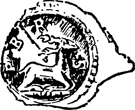
Fig. 67A. Lead Roundel From Sketch By Irvine (1/1;).
Close to the villa, but rather higher up the slope, we have traces of burials. Stone coffins were noted here in 1822, and more were excavated in 1854, partly in the spring and partly in the winter. In all two rows of burials were detected, 47 feet apart. The most northerly consisted of two stone coffins, with a skeleton and iron nails or studs, as if from boots, in each. One skeleton had an illegible brass coin in its mouth and three skulls at its feet, inside the coffin. Beside the coffins lay their displaced lids; one part of the lid covering the skelcton and coin bore a Roman inscription. The other row had three stone coffins, each with a skeleton and iron nails or studs inside, and beside the coffins the following: (a) an oblong stone box with a cover (14 by 20 inches) enclosing a horse's head and some other bones; (b) a stone cist (9 by 12 inches) with a lid and burnt human bones, and (c) two earthenware jars also containing burnt bones. A coin of Licinius was also picked up, but whether inside or near the second row of burials is not recorded, and other bones or skeletons were found lying outside the coffins. The burials appear to be principally if not wholly of late Roman date, though the horse's head is difficult to parallel.
Especial interest attaches to the inscribed slab, a block of stone 31 inches long by 18 inches high and 4 inches thick. It has of course nothing to do with the interments, but was used up again after its original purpose had expired, as part of a coffin lid. It reads (fig. 68):
Pro salute Imp. Caes. M. Aur(elii) Antonini felicis invicti Aug(usti) n(ostri), Naevius, Aug(usti) lib(ertus), adiut(or) proc(uratorum), principia ruina opressa (sic) a solo restituit.
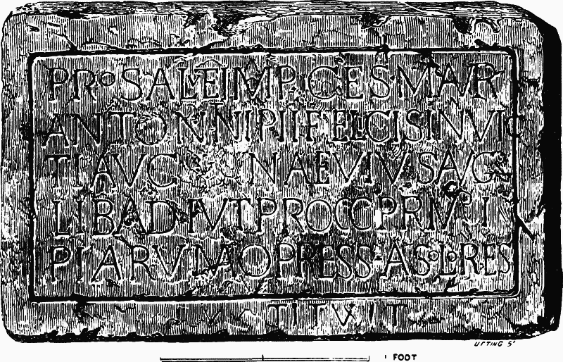
Fig. 68. Inscribed Slab
'For the safety of our Emperor M. Aurelius Antoninus (probably Caracalla, a.d. 211–217), the Fortunate and Unconquerable, Naevius, freedman of the Emperor and assistant to the Procurators, has restored from the ground-level the ruined Principia.' (fn. 54)
What exactly these principia were, is doubtful. The word usually denotes the headquarters in a fort, and so it has been taken by most writers to prove that a fort stood on Combe Down early in the third century. However, no trace of such a fort has ever been detected. Moreover, the existence of a fort on such a spot as the vicinity of Bath about a.d. 215 is not especially likely, and an inferior civil official —concerned with finance and a freedman by rank—is not in any case the proper person to rebuild the most important structure in a military establishment. It is possible that principia may here bear a civil significance and denote a residence of some financial authority connected with the procurators or an office of some Imperial estate. We do not know the particular work performed by the procurators in question. It is therefore useless to speculate on the minuter details of the problem. But procurators in the provinces were frequently entrusted, among their other duties, with the supervision of the publicani or middlemen who farmed certain State taxes and revenues, and Naevius on Combe Down may have stood in some such relation to the publicani whom we thought to detect on the leaden seal found in the villa. Our clues, however, are very scanty. It is rash to do more than suggest that we have here, not a fort, but some scattered vestiges of the Roman civil administration or the service of the Imperial domains.
On the whole, we seem to detect on this site two elements. One belongs to the Imperial administration at the opening of the third century a.d. The other is a residence, occupied possibly in the third century and more certainly in the fourth. It may be that the two are connected and that Naevius and his successors occupied the house of which we have traces. But as to this our evidence is silent. The house was, at any rate, inhabited till near the end of the fourth century. Then, as an abundant layer of ashes seems to indicate, it was burnt. It has been conjectured—as by Mr. Cuming—that some of the burials and some of the iron objects belong to a post-Roman and indeed an English date. That might imply that the site was afterwards occupied by the English. But the character of the objects hardly justifies the conjecture.
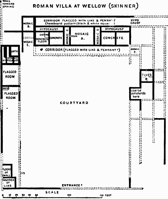
Fig. 69. Plan of Roman Villa at Wellow.
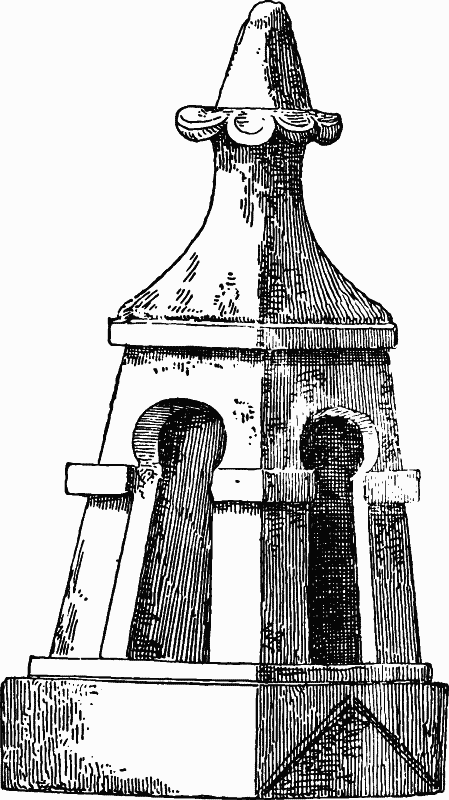
Fig. 70. Finial 18 Inches High.
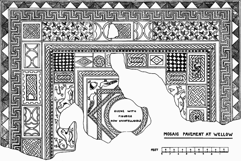
Fig. 71. Wellow Mosaic A.
(20) Wellow. This parish contains the site of a large and sumptuous villa. It stood in what is now Upper Hayes, three-quarters of a mile west of Wellow church, halfway down a long hillside that slopes gently south-eastwards to Midford brook. (fn. 55) Portions of it have been explored on six different occasions. In 1685 a mosaic was found (A on plan). In 1737 this mosaic was reopened and two more were uncovered. In 1787 a visitor to the neighbourhood attempted a little piece of excavation. In 1807, a resident, Col. John Leigh of Combe Hay, reopened the three previously discovered mosaics and also broke fresh ground. In 1820–2 the Rev. John Skinner of Camerton (p. 290) promoted a more or less systematic examination of the site. Finally in 1846 the Rev. C. Paul, vicar of Wellow, found a small building half a mile from the villa, which may or may not belong to it and which may best be treated separately (No. 21). (fn. 56)
The villa itself was a normal instance of the courtyard house (fig. 69). With its yard, it occupied an area of about 248 by 262 feet. Its buildings ran continuously round the north, east and west sides of this area, while the south side was closed by a single wall, in which was doubtless the entrance. On the north side, looking down the yard, stood the principal dwelling, provided with a corridor or cloister on each side of it, and adorned with elaborate mosaics and warming apparatus. On its right hand, in the north part of the west wing, were the bathing apartments. The rest of the wings are imperfectly known to us, but seem to have contained servants' rooms and possibly stores, stables and the like. Some 'stoves for smelting iron and lead ore' noted by Skinner at R may be traces of a channelled hypocaust.
The small structural remains found in the villa comprise painted wall plaster, ridge and other tiles, hexagonal roofing slabs, a stone finial like that unearthed in the Baths at Bath (figs. 38, 70) and several striking mosaics. The principal pavement adorned the large room A (26 by 34 feet) It was unfortunately very fragmentary when first found in 1685 and has now, probably, entirely perished ; but enough has been recorded by successive observers to show its main character (fig. 71). Its general scheme is a central figured panel surrounded by interlacing squares and geometrical ornament. This is a common scheme in Roman mosaic work. But its application at Wellow is noteworthy, for the frame of geometrical ornament is singularly rich and elaborate and contains a curiously large number of different patterns arranged somewhat unsymmetrically in small pieces, and, as it were, in patchwork. This appears to be due to design and not to mending. (fn. 57) Similar patchwork, though on a considerably smaller scale, occurs at Newton St. Loe (above, No. 7). But so far as I know, it is not common. Nor indeed is it so artistically successful that we should expect to meet it frequently. For despite its elaboration, or perhaps because of that, it is somewhat barbaric and perhaps a trifle oriental in conception. The narrow rooms or passages on either side of A (C and D in the plan) were floored with good geometrical mosaics suitable to corridors. That marked C, first found in 1737, contains five oblong partitions of common geometrical devices. (fn. 58) That marked D, opened in 1807, shows three oblong partitions, the centre made up of intersecting circles and the ends of diagonally bisected squares. (fn. 59) One other mosaic (B), first found in 1737, and reopened and partly destroyed in 1807, was an oblong floor in red, white, blue and dark brown or black (fig. 72). The centre was a square piece of singularly rich and elaborate key pattern: at each end were two conventional animals amongst still more conventional foliage, and the whole was bordered by a plain key pattern. (fn. 60) The other mosaics (rooms E, F and the bath) were so ill-preserved that reconstruction of their designs was judged by the excavators to be impossible. On the whole, the Wellow mosaics, though full of conventional elements and not devoid of barbaric extravagance, take a fairly high place among the tessellated pavements of Britain.
The smaller objects found in the villa are but scantily recorded. Skinner notes Samian and other potsherds, glass, a bronze spoon, two ring fibulae, an uninscribed fibula resembling the Aucissa type (p. 343), an iron ladle and handle, and late coins—of Severus Alexander, Gallienus, Allectus (noted by Warner), the Constantinian family and Valentinian.
The villa had round it outbuildings. From its north-west corner a wall ran northwards in the direction of an excellent spring, which was about 70 or 80 yards away. Near this wall were found many bones of edible animals—deer, pigs, sheep, oxen—and also the shells of oysters, cockles, limpets, periwinkles and the like. Here too was an outbuilding in which Mr. Skinner found upwards of a bushel of discarded pieces of blue and white lias and brick tesserae heaped together, as if (so he imagined) the outhouse were used for repairing the mosaic floors of the villa.
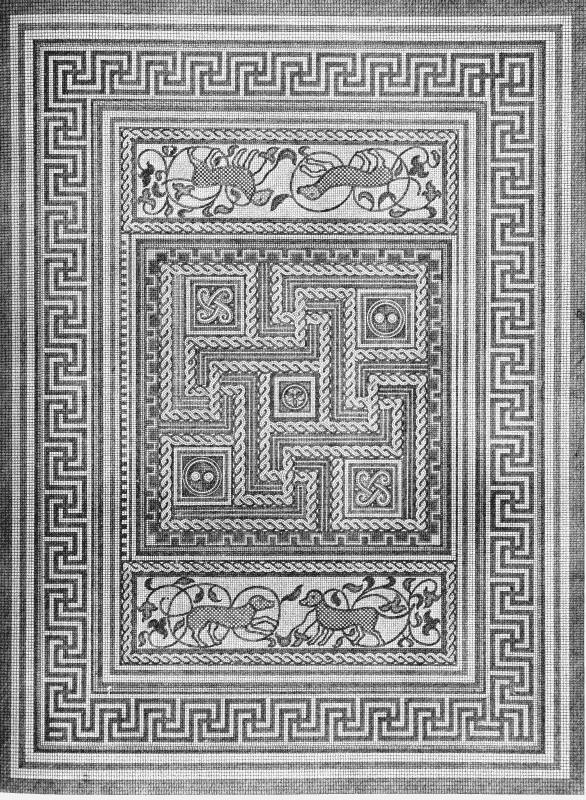
Fig. 72. Wellow Mosaic B. (Vetusta Monumenta.)
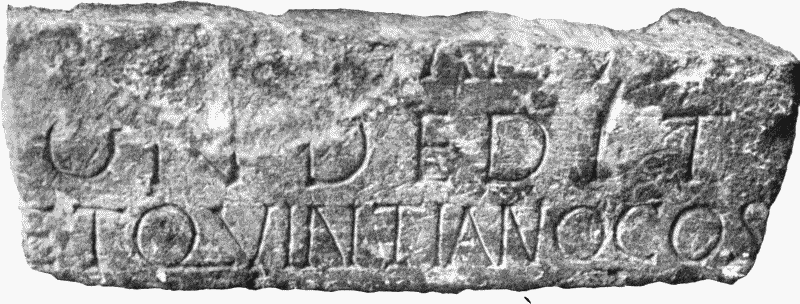
Fig. 73. Inscription from Camerton (p. 291).

Fig. 74. Relief from Wellow (p. 315).
(21) Wellow. Besides the sumptuous house just described, other Roman buildings have been detected in the parish of Wellow. In 1846 the vicar, the Rev. C. Paul, traced foundations, pavements and other signs of permanent Roman occupation about half a mile distant. Neither the position of this building nor the details of its plan and contents have been recorded. The principal discovery (fig. 74) seems to have been a sculptured stone 14 inches high and broad and 2¾ inches thick, bearing a bas-relief of two draped female figures, and an undraped male figure, all unfortunately headless. The female figures hold staves, or something similar, in each hand. The male figure has behind him a cloak dependent from his shoulders, and holds in his right hand a purse and in his left a staff. Possibly this is the end of a caduceus and the figure may be that of Mercury. But the identity of the two female figures is not clear. Other finds in this building were potsherds and much charred wood, the latter showing that the building had been burnt. Close by, a denarius of Augustus (Cohen, i. p. 70, No. 51) was picked up. (fn. 61)
Three other references to Roman buildings in Wellow parish occur in Mr. Skinner's papers. (fn. 62) He records foundations, coins and potsherds as noticed a mile west by south at Eckwick (or Eckweek) Farm and half a mile west by north at White Ox Mead. It is possible that the latter may be the site probed by Mr. Paul in 1846. He also mentions foundations, potsherds and a coin of Tetricus, as noticed in Shepherd's Mead, to the right of the road as one goes from Wellow towards Hinton. (fn. 63)
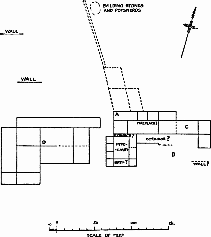
Fig. 75. Paulton Villas. (Skinner.)
(22) Paulton. In January and the following months of 1818, Mr. Skinner, rector of Camerton (p. 290), excavated two adjacent houses in some fields on high ground between Paulton and Camerton. I have failed to discover the precise site. It is described as overlooking Clandown with a view into Wiltshire, and just south of the 'Ridgeway' road, to which Mr. Skinner attached an undue importance, and it appears to be rather nearer to Paulton than to Camerton. The houses themselves, as planned by their excavator, appear to be a pair of ordinary rural dwelling-houses of the corridor type (fig. 75). Probably they belonged to the same estate; one may have sheltered the lord, and the other his servants or slaves. The eastern house was the better built. Like many corridor houses, it contained a special wing with a large hypocaust. Room C was floored with cement, and its walls were plastered with stucco painted green, yellow, and brown. Two pits, 7 feet deep, containing coins of Pius and Faustina, a Samian cup, and a graceful urn of Castor ware (fig. 76), were found immediately north of the northwest angle of the house. Close by, at A on the plan, an interment was found in a corner of a room. Another interment— an urn with burnt bones and a silver coin of Pius—was in the front of the house at B. The second house was not so well built, but it is said to have contained some sort of tessellated floor. Among the ordinary objects recorded as found in these houses were pieces of Samian inscribed SVORINEDO (misread for Suobnedo), ADVOOSIO (misread for Advocisi officina), and TIT.VRONIS.
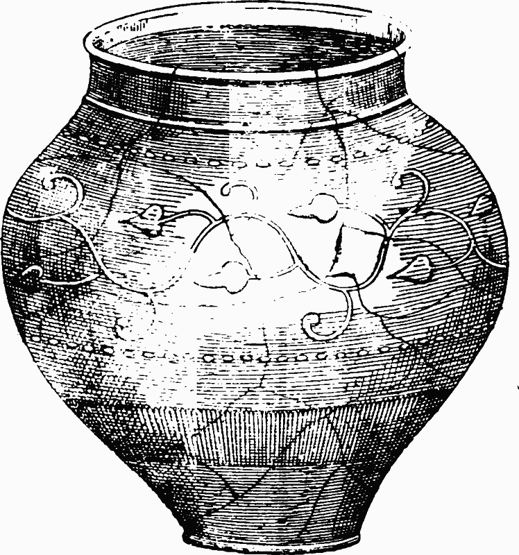
Fig. 76. Dark Brown Urn, 5 inches high, ornamented with leaf Pattern in Relief, found in 1818: now in Bristol Museum.
Traces of other buildings or walls were noticed both on the north and on the south of these houses. But nothing definite can be made out of Mr. Skinner's plans, and it is likely enough that the remains belonged to outhouses, sheds, and enclosures. (fn. 64)
(23) Radstock. Two refuse pits were excavated in 1897 and 1898 in quarries on the south-east of Radstock. The first was found in Tyning quarry about 1,200 yards west of the Fosse. It yielded an iron nail, a quern, a spindle whorl, much black pottery, mostly British or earlier, but some perhaps Roman (?), much charcoal, burnt bones and teeth. The second was found near Radstock parish church, in Jubilee field, on the west of the road to Kilmersdon, and 1,320 yards south-west of the first. It was 6 feet deep, and measured 6 feet across at the top. It contained much black earth, charcoal, a large number of bones of animals, teeth, several bronze fibulae, tweezers, many iron nails, much common pottery, grey and black and red, embossed and other Samian, one piece with VIRIL scratched outside, flanged tiles, floor plaster and traces of wattle and dab. (fn. 65) These remains indicate the existence in the neighbourhood of either a villa, or (as has been also suggested) a Romano-British village, just off the Fosse.
(24) Whatley. Here was a good sized villa planted in open country close to a water brook, about two miles west of Frome, and immediately south of Whatley House, in a field called Chessil, just inside the north boundary of Nunney parish. It was discovered in August 1837, by men digging holes for posts, and was partly excavated in the following months, and again in 1848, and part of it is still open under the cover of a shed. Its ground plan has not been traced, but it seems to have consisted of at least one long row of rooms with hypocausts and apsidal chambers, as if of baths. The principal object found in it was a mosaic floor, worked in seven colours, and filling two large connected rooms, one rectangular and the other apsidal (fig. 77). The former showed a head of Cybele set amidst geometrical motives. In the other we have a procession of beasts, including an elephant, round a defaced central square which may have contained Orpheus. The smaller finds are painted wall plaster, tiles, window glass, Samian and other potsherds, spindlewhorls, a bronze figurine of a tiny deer (?), and numerous coins, almost all of which are copper of the late third and early fourth centuries. A lane called Whiteway runs from near the villa towards the village of Nunney. (fn. 66)
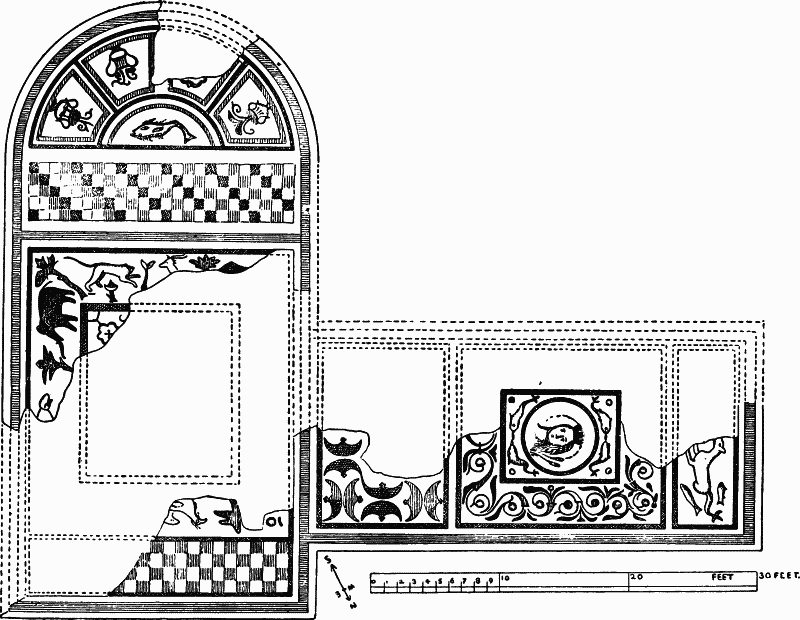
Fig. 77. Roman Tessellated Pavement at Nunney, Somerset.
(25) Shepton Mallet. Interesting remains of inhabitation have come to light near Shepton, partly on the east and partly on the west of the modern town. They have unfortunately not attracted the attention they deserve, and but for the wise exertions of the late Mr. John Phillis, we should know little about them.
(1) On the east of the town was a dwelling-house. It was planted close to the Fosse, and on the west side of it, about half way between Charlton and Cannard's Grave, just at the point where the Somerset and Dorset Railway crosses the Roman road. Its discovery was due to the doubling of that line in 1887, and, as too often happens in such cases, it was not followed up. But Mr. Phillis was able to note definite traces of walling about 40 feet in length, many roof slates of a thin shaley sandstone with the nails in them, and a well or rubbish pit 15 feet deep. The smaller finds, principally rescued by him, were interesting—not a little Samian, including a few embossed pieces of the first century (type, Dragendorff 29), and many of the second century (type 57), among it two stamps, ERICI M and BVRRIO F; much common ware of many sorts, pelves, etc.; over thirty fibulae, and among them an uninscribed Aucissa specimen and others of fairly early date; bronze spoons, buckles, tweezers, and the like; iron keys and nails and a knife blade, and some querns. The coins numbered over 120, and comprised 1 Republican, 22 of the first two centuries (1 Nero, 8 Claudius, 1 Vespasian, etc.), and many of the period 250–400. To these general finds of coins two hoards have probably to be added. One, consisting of perhaps 200 consular and imperial silver, buried in an earthen jar, seems to have been found at Charlton about 1880. The other is more dubious. Glastonbury Museum contains a large red urn found there in 1888, with 15 coins of the late third century and of Chlorus and Crispus. But it is not quite clear whether the 15 coins are or are not part of a hoard. Finally, in 1890 three skeletons with rings were found beside the Fosse near Charlton. (fn. 67)
(2) Besides these remains of houses and inhabitation, several potters' kilns have been found near Shepton. The fragments of one were noted by Mr. Phillis near the Charlton discoveries. Five others were found some years earlier on the west side of the town, when the AngloBavarian Brewery (as it is now called) was built, in and after November 1864. One of the kilns first excavated is described as a circular structure excavated in the hill side, with a space in front, the floor 6 feet below the surface, the sides protected by stone jambs, the pottery shelf upheld by clay pillars, and perforated by nine holes of 3–9 inches in diameter, and the whole roofed by a dome (fig. 78). Several cups were found actually on the shelf or in the holes (fig. 79). The ware was of a red or buff colour, hard and somewhat resembling in texture the modern flowerpot. Some black ware and a pelvis were also discovered, but no Samian occurred near the kilns. In an adjoining field a pit was soon after found, containing coins of the Constantine family, animal bones and other refuse. (fn. 68)
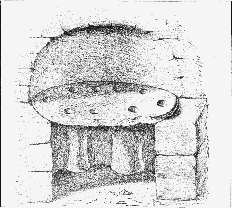
Fig. 78. Potters' Kiln, near Shepton
All these facts prove that the wayside of the Fosse south of Charlton was inhabited during all the Roman period, from the first to the fourth century. What was the precise character of the inhabitants must be left doubtful. It is not likely that the pottery kilns were employed during any great number of years, or that the houses were inhabited principally by the potters. We may more probably have to deal with a wayside inn or a farm house or villa.
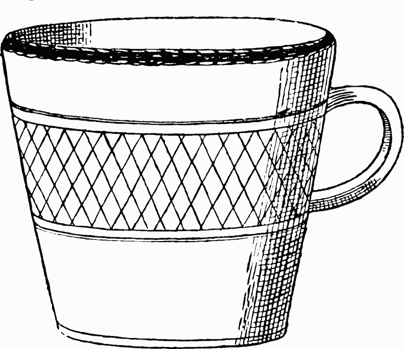
Fig. 79. Cup found in Kiln, near Shepton
(26) West Cranmore. Skinner records a pavement found about 1800 at West Cranmore, and Sir R. C. Hoare notes coins and a fragment of a pavement. These are probably one and the same find. It is surprising that nothing has since been heard of Roman remains at this place. (fn. 69)
(27) Chesterblade. At Chesterblade, two miles north-east of Evercreech, Mr. Joseph Allen found on his farm a few years ago some Roman remains indicating a villa or house. These were: foundations, potsherds, a lamp and coins (1 Domitian, 1 Hadrian, 2 Pius, 13 of circa a.d. 270–400). The site still awaits proper excavation. Its name may seem to suit Mr. Allen's discoveries, but it is unfortunately of obscure derivation. Mr. W. H. Stevenson tells me that the second half is doubtful in meaning, and the first may be from caestel, not from ceaster. It is, however, an old name occurring in the form 'Cestrebald' in a Somerset Plea of a.d. 1225. The neighbouring camp on Smalldown, recently excavated, appears not to be Roman but of much greater antiquity. (fn. 70)
(28) Ditcheat. A villa was excavated in this parish by the late Colonel Woodforde about 1820. The site is a flat meadow called 'Laverns' on the north bank of the Brue and east of the road between Ansford Bridge and Brook House Inn, near to Castle Cary railway station. There were discovered, besides extensive foundations, a silver coin of Constantius II (Cohen 259), 6 or more bronze coins, including one or two of Tetricus, some 'coal money,' white and red tesserae of a mosaic, a curious circular armlet of what appears to be coal, potsherds and tiles. No proper record of the excavation exists, nor is anything now visible above ground. (fn. 71)
(29) Discove (about a mile south-east of Bruton). A tessellated pavement is said by Collinson to have been found here in 1711. But nothing more has been heard of it since, nor have I been able to learn anything by local inquiries. (fn. 72)
(30) Bratton. Insignificant foundations, tiles, coins, including two of Constantius II, pottery, etc., were found about 1832 on Castle Hill, a spur of Bratton Hill, and indicate a rural building of some sort. But we must wait for further evidence till we can decide its size and importance. (fn. 73)
(31) Bayford. Mr. George Sweetman of Wincanton tells me that a Roman villa is said to have been found in 1764 in building a new house at Bayford Lodge, a mile east of Wincanton, in the parish of Stoke Trister. No trace now remains of it. But its tradition has been consciously or unconsciously used by Mr. A. T. Quiller-Couch in his novel The Westcotes.
IV. VILLAS WEST OF THE FOSSE NEAR STREET, SOMERTON, LANGPORT AND THE POLDEN HILLS (32–50).
This group demands a preliminary observation. As the map shows, a very considerable number of villas is recorded from the neighbourhood of Somerton. For the most part they lie west or north of it, on the high lands that fringe the eastern limits of the great marshes of the Parrett and Carey. Those nearest to Somerton were mainly excavated about 1820–30 by a local antiquarian, Mr. Samuel Hasell, and his results were very briefly published by Sir R. C. Hoare in a privately printed pamphlet. How far Mr. Hasell was competent for his task is not recorded. But I have a suspicion—which at least one good judge shares with me—that he was an enthusiast and saw foundations too easily. The case has been complicated by his successors. The Ordnance Survey marks on its six-inch sheets most of its villas and two new ones. The surveyors appear to have relied, partly on a map issued by Hoare (fig. 80) and partly on local information. The result is unsatisfactory. Hoare's map is quite rough, and the sites on it are necessarily also marked roughly. But the Ordnance mapmakers seem to have transferred them mechanically to their own otherwise accurate map. The apparent precision which results from this process is of course illusory. The surveyors' local information is perhaps equally open to criticism. In consequence, several of the Ordnance sites are, as I believe, wrong. One certainly, near Hurcot, is physically impossible. Unfortunately, I have failed to secure any living witnesses to Roman remains on the sites in question, and the sites themselves, which I have visited, are now mostly under grass and afford little evidence to the visitor. Until, therefore, excavations be undertaken, or chance brings discoveries, it seems best to include the alleged villas with a full caution.
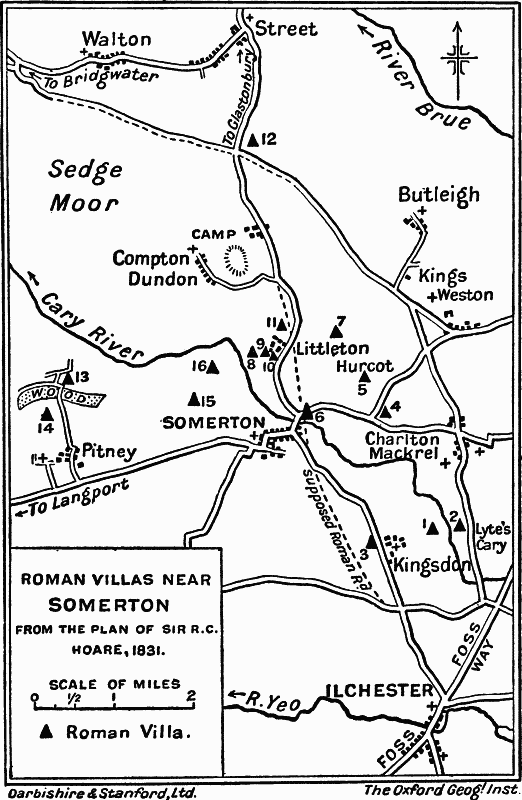
Fig. 80. Plan of Roman Villas, near Somerton
(32) Street (Butleigh Wootton). At Marshall's Elm, in the parish of Street, in a field and wood just north-east of the junction of the roads from Charlton Mackrell and Somerton, there was discovered about 1825 'the site of an extensive villa in Butleigh Bottom, in which, on a partial examination, were found coins of Claudius Gothicus and other Roman emperors.' Samian and other potsherds were picked up some time before 1850 near and east of the same spot. No traces are now visible, except that the ground has obviously been disturbed. (fn. 74)
(33) Kingweston. A villa is marked here by the Ordnance Surveyors about half a mile east of the village. This is not mentioned by Hoare, nor is anything recorded of it elsewhere. But perhaps we might connect it with some coins found at Barton St. David, half a mile away. (fn. 75)
(34) Copley (Kingweston). In Copley Wood, a little east of Littleton and in the parish of Kingweston, Sir R. C. Hoare records 'the sites of several small habitations irregularly interspersed over a considerable space of ground. They have been explored and produced coins of Constantine, Roman pottery, fibulae, angular tiles, etc., but no traces of mosaic pavements. The land around is high and barren.' No further record of the remains exists. The ruins of a stone building exist in Copley Wood at a spot called Magotty Pagotty. But so far as they are now visible on the surface, they might well be of fairly recent date. They are however marked as Roman by the Ordnance Surveyors. (fn. 76)
(35) Hurcot. A villa lay 1¼ miles north-east of Somerton, at Hurcot Farm, only ½ mile distant from the villas of Somerton and Charlton Mackrell (Nos. 36, 38). Hoare describes it as 'situated at the foot of a hill facing the south, and commanding a fine view of the neighbouring country ; it covers about half an acre of ground, and a clear spring of water rises at a short distance from the ruins. Traces of hypocausts, baths and mosaic pavements were discovered.' The discovery was made in 1827 by Samuel Hasell, who, according to other records, found a good mosaic in a room measuring 12 by 14 feet, and another pavement, or it may be the same, of a purely geometrical pattern of guilloche and triangle, in the usual red, white and blue, measuring 4 feet square. But no further remains are recorded that might suggest the shape or size of the villa, or the approximate date of its occupation. (fn. 77)
(36) Charlton Mackrell. Sir R. C. Hoare states that a villa or other rural building was partially examined by Mr. S. Hasell about a mile east of Somerton, near the junction of the roads leading to that town from Charlton Mackrell and from Kingweston, just under Snap or Windmill Hill. The finds included 'herringbone walls, angular tiles, coins of Claudius Gothicus, with others of the Lower Empire, and instruments of iron,' but no mosaics, and the ruins seemed to have been previously disturbed. Nothing is now visible at or near the site marked by Hoare (fig. 80, No. 4), and the building appears to have been of humble character. About 1846, a parcel of forty coins dating from Constantius II to Theodosius was found somewhere near the building, and also three stone coffins of uncertain age. (fn. 78)
(37) Littleton. About a mile north of Somerton, and on the west of the road from Somerton to Street, two villas were excavated by Mr. S. Hasell, the first in 1822, and the second in 1827. Both were described by Sir R. C. Hoare.
(1) In the one case, close to Littleton itself, foundations were traced which at first appeared to belong to three distinct buildings, but which seemed on further excavation to form one large villa—possibly a courtyard house of the Brading type (fig. 6). Besides this, an adjoining area of about 30 acres was found to be 'entirely covered with buildings, and on digging deep into the soil, produced foundations of walls of herring-bone structure, bricks, tiles, coins, fragments of mosaics, etc.' This would indicate a village rather than a villa. But the 'area of 30 acres' may be a serious exaggeration. It does not seem to be confirmed by any subsequent discoveries.
(2) About a third of a mile north of this a second villa was discovered. This was more carefully examined and described than most of the villas in this neighbourhood, and a plan was actually drawn (fig. 81). It lay 'in a pleasant meadow, with a fine stream running close to it,' and was a spacious structure, occupying, with outbuildings, an area of two and a half acres, arranged on the courtyard plan. Only the north side was excavated at all fully. There were found the principal apartments, consisting of a long corridor, measuring some 200 feet, and north of it a row of ten or eleven rooms, the largest measuring 16 by 20 feet, with four small rooms beyond them. The corridor seems to have been paved with mosaic originally, and mended with lias flags at a later date. Four rooms contained mosaics, which are said to have exhibited superior workmanship, but to have been much ruined. One had a representation of Bacchus (?) in the centre, and another an inscription, of which only the letters FLA remain. Three rooms were floored with lias flags or with terras. A hypocaust and furnace were found at the east and west ends, and flues in the centre room and in the small room to the west of it. South of the corridor and in the centre of it was a structure resembling a projecting porch, giving on to the courtyard. On the west side of this courtyard only one room was excavated, proving merely that there were buildings on this side. On the east side, 60 feet south of the main buildings, the baths were found, but were not entirely uncovered. This completes the list of ascertained rooms. Smaller remains included many potsherds, worked stone, and some coins dating from Vespasian onwards, but chiefly of the later Empire. (fn. 79)
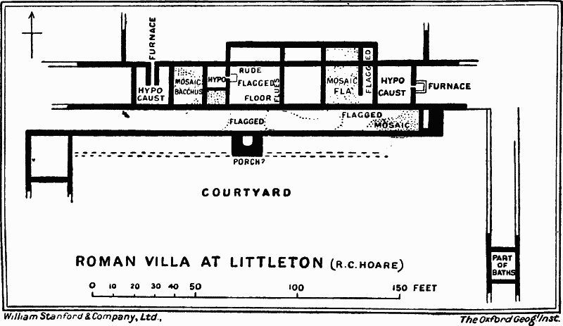
Fig. 81. Plan of Roman Villa at Littleton
In 1883 some coins of Postumus, Victorinus and Constantine were picked up at Littleton, and are now in the possession of Mr. Franklin of Taunton. From which of the two villas they came seems not to be recorded. (fn. 80)
(38) Somerton. Sir R. C. Hoare mentions a villa about ½ mile north-east of Somerton, on the line of the road to Charlton Mackrell and just north of the river Cary. It was excavated by Mr. Hasell, ' and Roman pottery, tiles, flues, and coins of Constantine, Antoninus, Victorinus, Postumus, etc., with foundations and tessellated floors,' were found. Other coins have since been picked up in the neighbourhood—two denarii of Hadrian, a 'First Brass' of Gordian, and some Third Brass from Constantine to Theodosius, indicating an occupation extending over the third and fourth centuries. (fn. 81)
(39) Two other villas in another part of this parish are marked by Sir R. C. Hoare on his map, but are not described in his text. They lie on the left bank of the river Cary, ¾ mile and a mile respectively north-west of Somerton. A villa, which might be the more northerly one, is marked by the Ordnance Surveyors near Etsome Farm, on the right bank of the river Cary. But if so, Hoare has put the house both on the wrong bank and on too high ground.
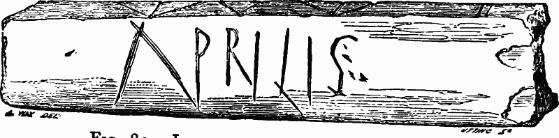
Fig. 82. Inscription from King's Sedgemoor. (Archaeological Journal.)
(40) King's Sedgemoor. Early in the nineteenth century Mr. S. Hasell found a Roman building below the peat on King's Sedgemoor near Somerton, and in it an iron ring or fibula 'cased in brass,' and a piece of bone (perhaps a handle) scored with the letters ΛPRILIS, Aprilis, perhaps the name of the owner (fig. 82). No further details seem to be preserved of the building. It may however be that which the Ordnance Survey marks, low down on the marsh level, about 250 yards north-west of Etsome Farm in the parish of Somerton. (fn. 82)
(41, 42) Kingsdon. Hoare records two villas here.
(1) The first stood on the west of the village and of the road leading from Ilchester to Somerton, about halfway between these places. Here some small remains were found, but not examined in Hoare's time. Nothing has been since recorded, and the existence of a villa here remains to be proved.
(2) The second lies about half a mile east of Kingsdon, on the west bank of the river Cary, just opposite to the villa at Lyte's Cary. Hoare mentions 'the site of a large villa, which has not been opened, the fields in which it is situated being in tillage : but the plough has brought up to the surface Roman brick, tiles, etc.' This is better evidence that a villa existed than we have for the preceding item. But it is nevertheless unsatisfactorily meagre. (fn. 83)
(43) Lyte's Cary. A villa is noticed here by Sir R. C. Hoare, (fn. 84) to the east of the river Cary, and between it and the road leading north to Charlton Mackrell, just opposite to the villa in Kingsdon parish. It was examined by Mr. Hasell, and the recorded finds are said to have included 'a hypocaust and other Roman remains.'
(44) Pitney. Two villas have been discovered in this parish, both to the north of the village, about 500 yards apart. They occupy very different positions.
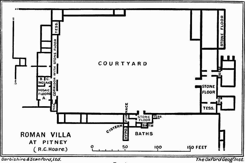
Fig. 83. Plan of Roman Villa at Pitney
The best explored and possibly the largest of these villas was examined by Mr. Hasell in 1828–9. It occupies a ledge of nearly flat ground, 45 feet above sea level, which intervenes between the marsh of King's Sedgemoor and the steep wooded side of Stowey or Stawell's Tree Hill (225 feet). The site, though cut off from a southern aspect, open only to the north, and somewhat secluded, is dry and well supplied with spring water. The villa itself formed a rectangular structure built round three sides of a large courtyard, the whole measuring 325 feet from east to west and 210 feet from north to south (fig. 83). At the west end of the courtyard was the house proper, a building of the corridor type, roofed with slates. Three rooms (A, B, C) were floored with mosaics worked in four colours, which, to judge by drawings of them, were more ambitious than artistic. The principal room (A) was divided into two partitions (fig. 84). The larger half was paved with a square mosaic enclosing an octagonal scheme. In this, eight figures, alternately male and female, some draped, some undraped, each in its own triangular panel, are grouped round a central figure, and the four corners of the whole are filled with heads. The series was taken by Sir R. C. Hoare to represent the master of the house surrounded by his servants paying their dues to him, and he connected it with the Mendip lead industry. But this is highly improbable. These nude or half-draped figures do not represent the maidservants and menservants of a villa, or of an estate. Their costume sufficiently demonstrates that. Plainly they form some series of deities or mythological personages, chosen without regard to their coherence or congruity, unless, indeed, the artist had in mind some illustration of the loves of the gods. Certainly we can distinguish Mercury with his caduceus, Neptune with his trident, and a Mithraic figure with a Persian cap. The mosaic of the other and smaller part of the room A contained four figures (one defaced), which might be called the Four Seasons, set in a key pattern of guilloche bands. This mosaic was destroyed in 1836. The mosaic of room B (fig. 86) shows in a central circular panel an undraped man recoiling from a snake, striking at it and upsetting a pail which he carries. The scene has been explained as Hercules killing the Hydra, but it does not well suit that interpretation. The mosaic of room C is small and simple, a geometrical scheme of interlacing circles (fig. 85). Two other rooms in the building had tessellated floors; the rest, except the flagged corridor, were floored with earth or gravel. On the south side of the courtyard was a row of rooms ending in the baths. On the east was a block which may be assigned to the servants. The house appears to have been occupied for long years, since in some rooms three terras or plaster floors and a flagged one were found one above the other. The minor objects discovered in the excavation have been imperfectly recorded. Chief among them are two fragments, apparently sepulchral inscriptions, found in the courtyard. (a) PATERPATRI-SANC
(b) VIXISIN
TRIGINTA
QVΛECAPI
NONOΛ
The second obviously contained some common sepulchral formula, such as vixi sine ulla macula triginta annos, ' I lived a spotless life for thirty years.' Among other recorded finds were painted wall-plaster, leaden water pipes and a clay plug, stone hypocaust-pillars and stone weights—once in Mr. Stradling's Museum at Chilton Polden. I have not been able to ascertain the present home either of the inscriptions or of the other objects. (fn. 85)
(45) The other Pitney villa was situated on the high ground south of the first villa, at an elevation of about 200 feet above the sea, with a good prospect south and west. It was first detected about 1828 and was partly explored in 1861 by Mr. Chambers. Foundations, a mosaic of circles and squares interlacing in common fashion, potsherds, roof-tiles, etc., were discovered. But no proper description was ever issued. (fn. 86)
(46) High Ham. A villa was excavated in 1861 about a mile south of High Ham church and half a mile west of Low Ham, on slightly rising ground near Sam's Cross. A plan is said to have been made, but no report was ever issued. Two mosaics were found, drawings of which, unfortunately ill-suited for reproduction, exist in Taunton Museum. One contained rectangular panels with conventional flowers and leaves inside a cable border. The other was a plain geometrical variation on a key pattern. The small objects found included a few coins of the later Empire (Allectus, Chlorus, Constantine), black ware and rims of mortaria, roof slates of shale, and bones. (fn. 87)
(47) Langport, Huish Episcopi. The position of Langport is significant. At this point the marshy levels beside the Parrett give way to higher land on both sides, and the river itself narrows, thus affording a convenient place for a bridge and one that was easily defensible. Earthworks, which may be of very early date, have been traced to the north-east of the town and the river, and Stukeley casually calls the site Roman, though without any apparent authority. Since Stukeley's time, Roman remains have actually been found. The 'Roman road' traced about 1863 along the lower road of Langport, may or may not be really Roman. But pottery and coins were picked up in 1867 close to the railway station on the west bank of the river, and in the parish of Huish Episcopi, and tiles appear to have been found earlier on the same site. Captain Long has three coins found somewhere in Langport—a Second Brass of Trajan, a Third Brass of the Thirty Tyrants and another of the fourth century. These remains, and especially the tiles, suggest the existence of a villa or building on the west bank of the river. But even this requires to be proved by excavations, and no more extensive occupation is even suggested by our present evidence. (fn. 88)
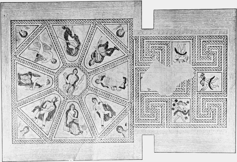
Fig. 84. Pitney Mosaic A. (Scale 1 : 50.)
(48–49) Drayton, Curry Rivel. Two villas or houses have been detected about 900 yards apart, both close to the boundary which separates these parishes and near the eastern end of a low ridge of rising ground which juts out from the Blackdown range towards Langport and the river Parrett. Whether the two belonged to the same estate cannot be decided.
(a) In Drayton parish, and near its western edge, 560 yards west of the church, in a field called Broadwell (on the tithe map No. 337), walls, paving, plaster, potsherds, a bronze ring, four coins (Claudius Gothicus, Carausius, Magnentius, Third Brass ; Pertinax (?), (silver) ; skeletons and urns containing human bones, were found about 1861 and the principal objects were given to the Taunton Museum. Some 400 yards west of this, in Currey Rivel parish, part of a fibula, two bits of Samian and other potsherds came to light at the same time.
(b) At Stanchester in Curry Rivel parish, 700 yards east of the church, some tesserae from a floor, coins (First Brass of Pius and Trajan, and many later copper), Samian and other potsherds, bits of bronze, three whorls of Kimmeridge shale, and other small objects were found in 1865. Coins have also been found at Wiltown, another hamlet of Curry Rivel, lying on the south side of that village. (fn. 89)
(50) Bawdrip. A Roman villa seems to have stood in or very near this parish, possibly at Churchie Bushes, a field about half a mile east of Bawdrip village on the south slope of the Polden Hills. Paschal, writing in 1689 to Aubrey, mentions 'a pavement discovered in a ploughed field at Bawdrip some years ago.' Stradling, writing from Chedzoy in 1827 to Skinner, says that a villa had just been found in the next parish and on the south side of the Polden Hills, and had yielded black earth, flue tiles, potsherds, and a bluish-green bead. This bead appears to be the same as one found at Churchie Bushes, which was at first preserved in Mr. Stradling's museum and is now at Taunton. Churchie Bushes has also yielded a carved capital and some unglazed tiles, and might be accepted (subject to excavation) as the probable site of the villa. But it has also been identified as the site of a mediaeval chapel, and the matter is perhaps open to doubt. (fn. 90)
V. VILLAS NEAR THE FOSSE IN THE SOUTH OF THE COUNTY (51–58)
(51) East Coker. A villa was discovered in 1753 at a site which is described as about a mile and a half south of Yeovil, on the east side of the road leading to East Coker and near a good spring of water. Several rooms were distinguished and two mosaics, one figured and one of purely geometrical design. The figured mosaic (fig. 88) was laid over a hypocaust and measured 10 feet by 12 feet. Its colours were red, white and blue, and its general scheme a circle enclosed in an oblong. Outside the circle in the corners of the oblong were Mercuries' heads, and at its two ends a dog chased a hare or stag. Inside the circle was a curious and unusual scene. In front a female figure, draped over the knees, reclined on a couch. Another female figure, fully dressed, stood by, and, according to some accounts, a third helped to affix a robe round the reclining figure. Behind stood a man fully clad, in the attitude of exposition. The whole has been explained as depicting a surgeon about to operate on a patient, and this view may serve in place of anything better. The other mosaic showed a purely geometrical design of lozenges, octagons, asiatic shields, and the like and measured 10 feet by 14 feet. The smaller finds made in the villa included bricks, tiles, iron objects and burnt bones, but have not been properly recorded. (fn. 91)
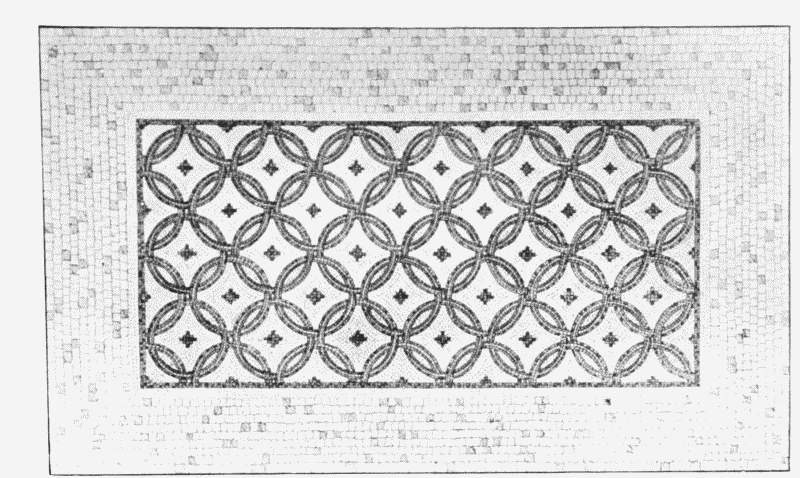
Fig. 85. Pitney Mosaic C (scale 3¼).
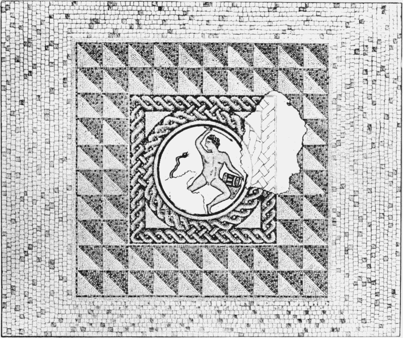
Fig. 86. Pitney Mosaic B (p. 327). (From Hasell) 3¼.
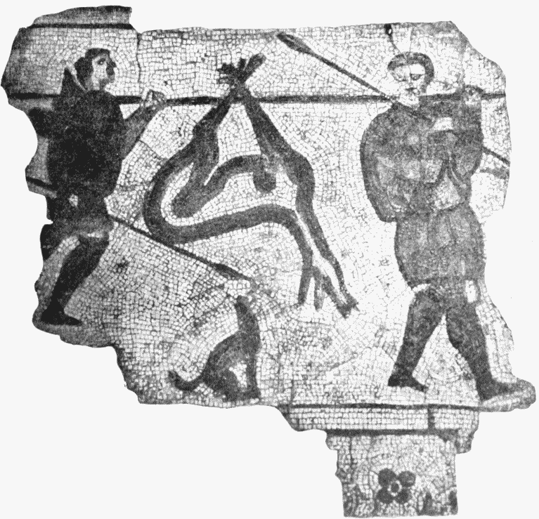
Fig. 87. Coker Mosaic (p. 330). (From a Photograph. Scale 1 : 15.)
Fig. 88. Mosaic found at East Coker, 1753.
Further discoveries were made about 1818 or 1820 at the same spot, or very close to it, in a field called Chesil or Chessells. Foundations, hypocausts, two mosaics, one figured and one geometrical, painted wall plaster, tiles, potsherds and coins were discovered. The figured mosaic was a fragment of about 3½ feet by 4 feet, representing two men returning from the chase carrying a spear each and a dead stag slung from a pole propped on their shoulders, with a small dog barking below the stag (fig. 87). The colours are blue-black, red and a yellowish drab, on a white ground. The coins were of Faustina (much defaced), Constantine, Crispus, Constantius (probably the second), Julian and Valens. (fn. 92)
It can hardly be doubted that the finds of 1753 and 1818–20 belong to the same villa, and that this formed a considerable and ambitiously ornamented structure, occupied, if not earlier, at any rate during the fourth century.
(52) West Coker. Here, in a field called Chessells, a villa was discovered and partially examined by Mr. John Moore in 1861. Few definite foundations were met with, but abundant evidences of a house, such as many blue and red tesserae from pavements, painted wall-plaster, tiles, roof slates and débris of building stone. The excavators thought that the villa had been burnt down, the spot rifled, and a subsequent building of rude character erected with burnt stones. Among the smaller finds were some pre-Roman items, suggesting that the site had been occupied at least by an interment of older date than the Roman period. The Roman items included Samian and other potsherds, many iron nails, some bits of bronze—including a rude statuette of Mars, 3 in. high, a bracelet and a pair of tweezers—bones of food animals and several coins—1 Lucilla, 1 Faustina, 1 Otacilia and Third Brass of Tetricus and other emperors to Valens, which show that the villa was occupied at least till near the end of the fourth century. Specially noteworthy is a bronze plaque, 1¾ inches high and 2¾ inches in length, on which an inscription has been punched—
DEO. MARTI
RIGISAMO
IVENTIVS
SABINVS
V. S. L. L. M
'To Mars Rigisamus, erected by Iuentius (that is Juventius) Sabinus.' Mars Rigisamus appears to be a Celtic deity Romanized; he occurs also on an inscription at Bourges in France. The whole of the West Coker remains suggest a house of some size and importance, and it is to be regretted that no proper plans or sketches have been published. (fn. 93)
(53) Norton sub Hamdon. At Norton sub Hamdon, near the Fosse, and underneath the south-west corner of Ham Hill, remains have been found in the village at Blackbarrowfield. These remains are: dark soil, potsherds, bones, an iron ring, a broken quern 6 feet deep, and also a well 39 feet deep, which, when excavated in 1897, yielded more potsherds, bones and querns, a small bronze fibula, tesserae, and a coin of Julia Mamaea (FECVN AVGVSTAE), this last found 6 feet deep. The tesserae indicate a pavement, and therefore a dwelling house of some sort. (fn. 94)
(54) South Petherton. In this parish three sites of Roman villas have been found or conjectured, but only one has adequate evidence.
(1) A villa is said to have existed at Jailers' Mill, on the river Parrett, about a mile north-east of South Petherton, and about ¾ mile north-west of the Fosse. "Here," says Collinson, "remains of Roman buildings, coins, urns, paterae and terras were dug up."
(2) A pavement indicating another villa is reported to have been uncovered in 1673 at Watergore, half a mile south of South Petherton, and on the Fosse. But the earliest reference to it occurs in Collinson more than a century later, and is not to be received with any great confidence.
(3) Foundations are also said by Collinson to have been found at Wigborough, but these are more probably mediaeval, as Dr. Norris tells me.
Coins have been picked up one by one at various places all over this parish, and a hoard was dug up in 1720 at Petherton Bridge, near the first villa. Whether the two figures in relief built into the parapet of the bridge are Roman seems very doubtful. (fn. 95)
(55) Seavington. A villa was found and excavated here in 1861 and 1862, in a field called Crimmelford, or Curnelford Kapp, about ¾ mile south of St. Michael Seavington, and 300 yards west of the Fosse. It is situated on slightly elevated ground sloping gently to the south, with a good view of the open country all round. The entire building was not uncovered, the excavations were badly recorded, and the remains were immediately destroyed. Hence it is impossible to form any idea as to the character or the date of the villa. Several rooms were laid open, some with hypocausts under them, and two containing mosaics. One of these had a geometrical pattern in red, white, and blue; the other was formed of squares of coarse red and white tesserae, while a third room was paved with red tiles about a foot square. Other remains included painted stucco from the walls, roof tiles, human skeletons, burnt bones, charcoal, potsherds, iron, bone pins and oyster shells, the débris of two ash pits. (fn. 96) A copper coin of Constantius II was found in 1889 in this parish, near Fowts, and coins are also ascribed to the neighbouring parish of Lopen (Alphabetical Index). These may be waifs from the villa.
(56) Chard. Two sites in this parish seem to have yielded significant remains. (1) Near St. Margaret's Chapel, on St. Margaret's Hill, in South Chard, quite close to the Fosse Way, remains were found in 1843, which may denote a villa of the third or fourth century. They consisted of tiles, tesserae, roof slates, opus signinum, potsherds, and coins dating from 250–380 a.d. (2) In a field near the Crewkerne road, just east of the town, foundations of buildings and three Roman coins were turned up in 1856. The records of both these finds are vague and unsatisfactory. But they justify us in assuming the existence of one, or possibly of two, houses. For a few scattered smaller finds in the parish of Chard see the alphabetical index. (fn. 97)
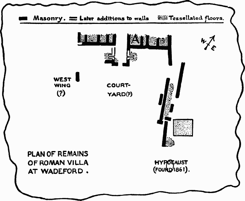
Fig. 89. Plan of Remains of Roman Villa at Wadeford
(57) Wadeford. In a sheltered and well watered spot amidst the eastern Blackdown hills, at Wadeford, in the parish of Combe St. Nicholas, stood a Roman villa of considerable pretensions. It was first discovered in 1810, and some excavations were attempted about 1861. The plan of the edifice was not very clearly traced; possibly it belonged to the courtyard type (fig. 89). The contents are better known. In 1810 two mosaics were unearthed. One, measuring 6 feet by 8 feet, showed a geometrical pattern of conventional flowers in circles and octagons in yellow, red, blue and grey on a white ground, the whole being set (as often) in a border of plain red brick tessellation (A on plan). The other pavement, 6 feet square, consisted of a central circular panel enclosed in two interlacing squares, which in their turn were contained by an octagon, while a square of maeander pattern bordered the whole. Both these mosaics perished soon after 1810 through frost. In 1861 five more pavements were found, all geometrical in pattern, mostly in very imperfect condition, and a hypocaust. The smaller finds included tiles, painted wall plaster, roof slates; a bronze hand, a ring fibula, and other small items in bronze; many potsherds and some coins—five First Brass (one of Claudius I) and some Third Brass of Gallienus, Tetricus and others. Scattered remains have also been picked up elsewhere in the parish. Such are a gold coin of Valentinian (RESTITVTOR REIPVBLICAE-SIRM), 5 Constantinian coins found in 1858 in the churchyard, and a fibula found at Mill Court. But Davidson's idea of a Roman road leading from Castle Neroche to Stretefordon-the-Axe may safely be rejected. (fn. 98)
(58) Whitestaunton. In a sheltered nook high in the Blackdown hills, close to the church and manor house of Whitestaunton, is a spring known as St. Agnes Well, reputed in the vicinity to be tepid, and to possess slight medicinal qualities. Close by, the remains of a Roman villa were found about 1845 in altering the road, and were partially excavated in 1882–3 by the late Mr. Charles Elton, Q.C., M.P., owner of the spot. The discoveries included living and bath rooms, hypocausts, mosaic flooring of geometrical patterns (guilloche borders, svastika, etc.), painted wall-plaster, flue tiles, roofing slates, and many smaller objects; Samian and other potsherds, window and other glass, metal and bone objects, lead piping and some balls of lead about the size of small oranges, iron slag, etc. Part of the villa is still open, but it does not reveal the general plan, which has still to be traced. (fn. 99)
5. THE LEAD MINES OF MENDIP
The high limestone plateau of Mendip, like the similar uplands of Derbyshire, was in old time rich with much store of lead, which was accessible on the surface and easily worked. This lead was known to the Britons before the Roman period; it was fully worked by the Romans and by generations of medieval miners, and is even now the object of occasional enterprise. It is to this recent enterprise that we owe the most part of our knowledge of the Roman operations. Our earlier antiquaries were ignorant of them. Camden is silent about Roman mines on Mendip, and explains an inscribed pig of Roman lead as a triumphal record of a Roman victory. Even two centuries later his editor, Gough, though understanding well enough the pig of lead, has nothing to say about the mines. The first discoveries, as it seems, were due to John Skinner, sometime rector of Camerton, and an enthusiastic explorer of Roman remains in his own parish and outside it (p. 290). He dug near Charterhouse on Mendip in 1819–20, and found traces of buildings and of lead-smelting of Roman date. Chance discoveries followed, and the existence of Roman mines in this region became generally recognized. But the principal part of our knowledge of these mines was not obtained till later. About 1867–76 attempts were made to resume the lead-mining, and in particular to resmelt the heaps of imperfectly treated ore left behind by Roman or medieval miners. To the archaeologist, though not perhaps to the financier, the result was most satisfactory. A vast quantity of Roman remains was obtained, and evidence revealed of an active mining industry and a large mining population in the Roman period. Unfortunately, the gains were not utilized. No proper watch was kept over the discoveries. No details were noted of the circumstances under which special objects were unearthed. No plans or drawings were prepared. Even the objects themselves were speedily scattered. Many were acquired by Mr. A. C. Pass of Clifton, by Sir Edward Hill and others. To-day, nearly thirty years after the time of discovery and dispersal, it is impossible to collect the scattered clues, or to give anything more than a general description. (fn. 100)
The Roman mining operations extended over a considerable area of Mendip between Blackdown on the north and the village of Priddy, (fn. 101) 4 miles away to the south, and finds have been made in various parts of this region. But the centre of activity lay just to the south of Blackdown (fig. 90). Here, close to the farm of Charterhouse and the meetingpoint of the parishes of Blagdon, Charterhouse and Ubley, is the gentle well-watered valley of Blackmoor. The bottom of the valley is full of old mining refuse, and its northern slope, and in particular three fields called Town Field and Upper and Lower Rains Batch have yielded the largest part of the Roman remains found in the neighbourhood.
These remains unfortunately include very little that throws light on the arrangement and the buildings of the mining settlement. Skinner records bricks, tiles, mortar, and also lead scoriae as found by him in 1820 in Upper and Lower Rains Batch, and estimates the extent covered by remains at sixty acres. Sir R. Colt Hoare, who probably visited the spot with Skinner, mentions a large tract covered with square and circular foundations. Later writers speak of wellmade drains three or four feet deep, foundations of huts, window glass, a layer of charcoal and scoriae two feet thick, and furnaces, some con taining traces of lead ore when found—all uncovered in the Town Field and very near it. (fn. 102) But they give no details, and nothing now survives to supply their omission. At the present day the one visible object of antiquity in the region is the so-called amphitheatre on the hillside a little north-west of the Town Field. It is a low, continuously circular bank of earth, enclosing a flat space some 75 feet in diameter. The bank rises 5–6 feet above the general level of the ground, and the interior is sunk about as much below the same level. We cannot decide its precise use, but it is ill-suited to form a pond or water reservoir, and the notion of a tiny amphitheatre is not wholly absurd. (fn. 103)
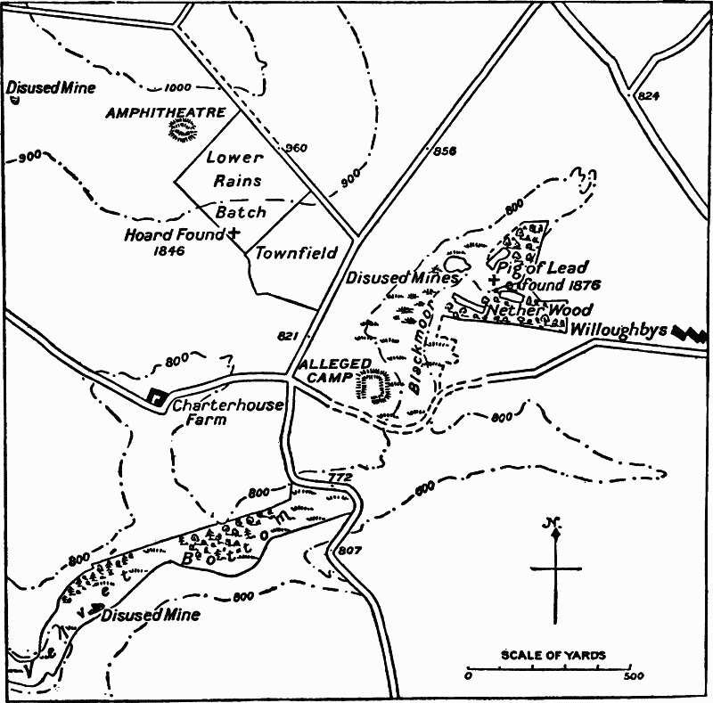
Fig. 90. Plan of Charterhouse Mining District.
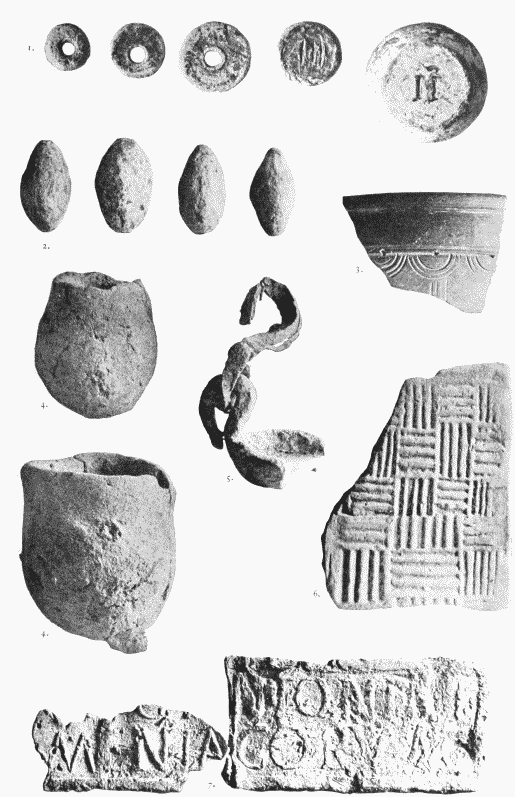
Fig. 91. Objects from Charterhouse, now in Taunton Museum. 1. Lead weights (2/3). 2. Clay Bullets (2/3). 3. Black incised ware (2/3). 4. Clay Crucibles (2/3). 5. Crucible with lead handle (1/2). 6. Brick imitating wicker work (1/2). 7. Parts of a lead pig (3/8). (See p. 337.)
But if traces of buildings be few, movable objects abound. Lead may naturally take the precedence in our list. Not only do great quantities of scoriae and charcoal mark old mining sites, perhaps of various dates. Definitely Roman activity is attested by a dozen inscribed pigs of lead, to be enumerated below, and by others which, though uninscribed, have been found among Roman remains, such as four discovered by Skinner, which vary in weight from eighty to one hundred pounds. A mass of pure lead, weighing 78 lb., smelted (as it would seem) but never run into a mould, was found about 1875. Smaller lead objects are plentiful: weights, some of which form sets (p. 344), a lamp, sling bullets 3½ ounces in weight, a counter inscribed CATV, nails, a small pick which may have been a toy, clay crucibles with lead still adhering, and so forth.
Bronze and iron also occur freely. Bronze fibulae, in particular, are plentiful, and the Pass collection alone numbers some 230 bow fibulae, 20 disk fibulae, mostly enamelled, and various penannular specimens (fig. 92). One or two of the bow fibulae approach the La-Téne types, and may be pre-Roman. Two others, of the Aucissa style (fig. 97), belong to the first century of our era. None suggest so late a date as the fourth century. One of the disk fibulae is dragonesque, and another represents a rare 'shield' type also found in the Derbyshire caves and elsewhere. (fn. 104) Besides these fibulae, we have to record a curious mask (fig. 94), a bell, keys, tweezers, pins, and the like—in all, a rich variety. Iron is also frequent, but naturally less well preserved. We find tools, chains (fig. 95), a chopper, a long knife, some rings, and five horseshoes, said by Mr. Scarth to be smaller than those now in use. (fn. 105)
The pottery includes the usual types. The Samian, preserved chiefly in the Taunton Museum, comprises embossed pieces of the first and second centuries (types 37, 38, 39 of Dragendorff and Dechelette). Interesting, though not at all uncommon, is a black ware with incised semicircles, for which see fig. 91. I may mention here also two bits of a small statuette in white clay, of a kind which is common especially in North Gaul and South Britain, (fn. 106) and some ten or twelve engraved signet gems, a few of which, such as the butting bull and the fishing cupid, shew good workmanship and may belong, as Mr. Lewis suggested, to the first century (fn. 107) (fig. 93). Sheet and bottle glass, bones and the usual débris also occur. To this list must be added three inscribed stones, all so fragmentary that they tell us little, and an oaken spade found 5 feet underground which may have a better claim than most of such finds to be called Romano-British. It was made of one solid block 21 inches long: its handle was square, and its blade, 11 inches long and 8 inches broad, was also squared at the sides. It is now in the Bristol Museum.
It remains to notice the coins. Of these it is impossible now to compile anything like a complete account. I can only give a list, drawn up by Mr. A. T. Martin, of some forty-five coins in the Pass collection, and supplement that by chance references in print and chance coins preserved elsewhere. The result is a long series, commencing with two British silver, two Republican and one Triumviral issue. The earliest Empire is represented by three coins of Tiberius, and thence onwards the list is continuous till the middle of the second century. The period a.d. 170–280 is less well represented. Constantinian issues are commoner, but the later part of the fourth century is a blank. (fn. 108) Only one hoard is known. This was discovered early in 1846 (not 1849) at Charterhouse, and the supposed spot is marked on the Ordnance Survey. It numbered some 900 coins, copper partly washed with silver, and covered the reigns of Claudius Gothicus, Aurelian, Tacitus, Probus, Carus, Diocletian, Maximian, etc., and was probably deposited, like many similar hoards, about the time of Carausius. (fn. 109)
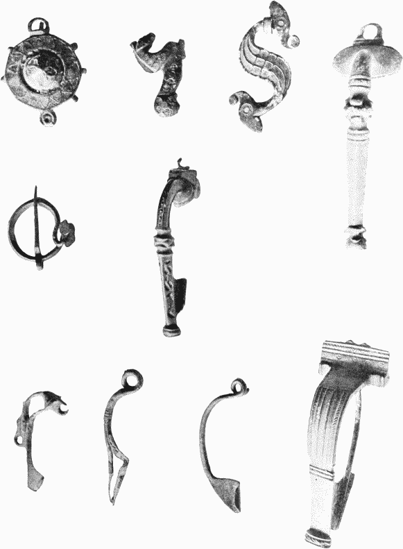
Fig. 92. Firulae from Charterhouse in the Pass Collection. (Bristol Museum). 1/1.
Fig. 93. Gems from Charterhouse. (After S. S. Lewis).
Such are the Roman remains of Charterhouse, so far as I have been able to gather the details from scattered sources. They are few and fragmentary enough, but they enable us to attempt some general sketch of the history of Roman lead mining on Mendip. The lead, it would seem, was known to the Britons before the Roman conquest. Thus much we may infer from the early fibulae and British coins dug up at Charterhouse, and from the occurrence of lead objects in the preRoman village a few miles off, at Glastonbury. After the conquest, the Romans at once developed the mines. Within five or six years, as the inscribed pigs of lead demonstrate, they were busy smelting the lead. Probably its export had already begun. Some years ago there was found in a harbour of northern France a lead pig bearing Nero's name, which there is reason to connect with the Mendip mines, (fn. 110) and it would appear to have been lost in the disembarkation on the French coast. This activity continued for more than a century. Our series of inscribed pigs and our list of coins are almost continuous till the reign of Marcus and Verus (a.d. 161–9). But there we meet a pause. A similar pause at a similar date confronts us elsewhere in Britain and in other provinces where mines were worked. (fn. 111) It is often ascribed to the altered fortunes of the Roman Empire, which, at the close of the second century, suffered a heavy change from peace and good government to frontier wars and weak or cruel rulers. But in part it may be due to exhaustion of accessible ores, and in part perhaps to changes in system involving changes in the inscriptions relating to the system. It is at least unlikely that where easily workable ore remained, it should have been left unworked in the third century. The demand for lead cannot have then altogether ceased, however much it may have diminished, and one may wonder whether the production did not continue, though perhaps the system changed and the fashion (for example) of making up the metal into heavy pigs may have varied. At Charterhouse, at any rate, a stone fragment seems to date from the reign of Septimius Severus (a.d. 193–208), though it is too short for certain interpretation and might be otherwise explained (p. 340). The coins, too, may perhaps suggest a revival of activity after about a.d. 284 in the period of Carausius and the Constantines. But here the darkness which at no point leaves the history of the mines drops deeper down, and of the later fourth century we have no record.
Equally little is known of the administration. All the inscribed pigs of lead bear emperors' names, and it is plain the Mendip mines, like all or nearly all provincial mines, were Imperial property. But of the officials and miners we know nothing directly. In the early days, perhaps, the soldiers of the Legio II Augusta were employed, as soldiers not infrequently were, in connexion with the mines. (fn. 112) For the rest we can only say that the activity of the mines must have been considerable during the early empire. The abundance of small objects and in particular of fibulae indicates a very considerable population of miners gathered round the pools of Blackmoor and the smelting furnaces of Townfield. The character of some of these objects, for instance the fibulae and signet gems, points further to some amount of civilized life. The occurrence, lastly, of three stone inscriptions may supply cause for supposing that the Latin language was more or less understood by the miners.
But at the end it is clear that the picture is imperfect. One leaves it with the conviction that the long grassy slopes and woods around Blackmoor conceal more than has yet been found, and that further exploration might reveal the vestiges of definite buildings, the records of the local administration, the furnaces and moulds of the smelters, and the roads or communications by which the mining settlement on the upland plateau sent its goods to the outer world. (fn. 113)
INSCRIPTIONS OF THE MENDIP LEAD MINES
(1–3, stone; 4–15, lead pigs; 16–21, small inscribed objects)
(1) Stone about 10 inches wide by 17 inches high. Found in 1875 in pulling down a farmbuilding of Mr. Benjamin Panes at Charterhouse, north of the Town Field; now lost.
The interpretation is uncertain. The opening suggests a dedication I(ovi) o(ptimo) m(aximo) [et num (inibus)] Aug. But the rest is obscure, except domo Roma in line 6, which suggests that some person named in the inscription was born in Rome. Professor Hübner pre ferred to regard the fragment as sepulchral. Unfortunately the reading is not certain. I have given the text according to three indifferent squeezes in the Library of the Society of Antiquaries: AVG in line 2 seems to me certain, as it did to Scarth on the original stone: line 5 is doubtful, line 7 (except the A) fairly sure: I do not think there was an eighth line. Published by Scarth, Bath Field Club, iii. 336; Watkin, Arch. Journ. xxxiii. 354 from Scarth; Hübner, Ephemeris, iii. 121, from a poor squeeze.
(2) Fragment found at Charterhouse in 1873 or 1874; now lost. The letters domin. Septimi might indicate the Emperor Septimius Severus or one of his immediate successors, but the surviving piece is too small to yield any certain sense and other interpretations are possible.
I have given the text from a drawing by the late J. T. Irvine, in the Library of the Society of Antiquaries. Published by Scarth, Brit. Arch. Assoc. Journ. xxxi. 142 (badly); Hübner Ephemeris, iii. 121, reproducing Scarth's bad copy; Watkin, Arch. Journ. xxxiii. 354.
(3) Fragment found about the same time and place as the preceding, but said not to form part of it; now lost. Its sense is, of course, irrecoverable. Published by the same writers as the preceding: I have copied a drawing by Irvine in the Society of Antiquaries' Library.
I have made considerable inquiries as to the fate of these stones and in particular of No. 1, but without result. No. 1 seems to have been last seen in the care of Mr. Scarth.
(4) Ploughed up in the reign of Henry VIII near Wookey Hole (Ochie Hole), the source of the Ochie or Axe, 5 miles south of Charterhouse: preserved for some time by the Duke of Norfolk in Lambeth, but soon lost. Size, weight and shape not recorded, except as oblonga plumbi tabula. Possibly it was merely the top surface of a pig, like Nos. 13–15, but Leland's Latin is not very explicit.
TI. CLAVD. CAESAR. AVG. P. M. TR. P. VIIII. IMP. XVI. DE BRITAN.
' Tiberius Claudius Caesar Augustus, pontifex Maximus, tribunitia potestate for the ninth year (a.d. 49), Imperator for the sixteenth time; from Britain.'
First published by Leland, Assertio incomparabilis Arthuri, London, 1544, fo. 23a. (Collectanea, ed. Hearne, 5, p. 45). Hence, presumably, Camden (ed. 1, 1586), pp. 104–5, reading CLAVDIVS and dividing the text (wrongly, as is plain) into two lines after P.M.: from Camden, Lambarde (s.v. Onky) and many more, whom, as wholly third hand, it is needless to cite; Hübner, C. 1201, follows Camden also.
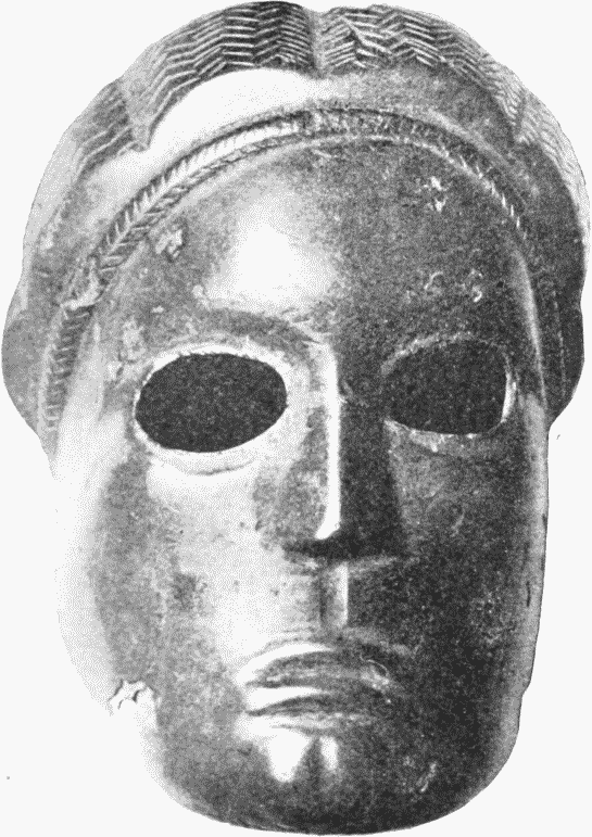
Fig. 94. Bronze Mask (1/1). (Pass Collection.)
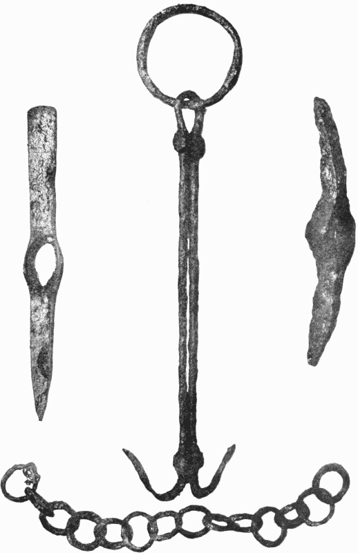
Fig. 95. Iron Implements (1/1).
Remains from Charterhouse on Mendip.
Leland and Camden took the object to be a trophy, but it is plainly a lead pig from the Mendip mines. Possibly enough the letters DE BRITAN may have been on the side and the rest on the face of the pig if it was a perfect specimen, but Leland gives the whole without division of lines.
(5) Pig of lead found in August 1853 near Blagdon, on the northern flank of Mendip; now in the British Museum. Weight 163 lb.; length at base, 24 inches; width, 6¼ inches. Inscribed both on the top and on one side (fig. 96).
Fig. 96. (Archaeologie.)
On the top On the side, twice over
BRITANNIC[symbol]. AVG. FI V. ET. P
'(The lead of) Britannicus son of Augustus, smelted in the consulship of Veranius and Pompeius (a.d. 49).' This explanation, first offered by Hübner, seems to be the best explanation of the inscription on the side. The top evidently refers to Britannicus son of Claudius, born in a.d. 42, heir to Claudius till superseded in favour of Nero in 48 or 49, murdered 55. It would seem unlikely that his name should be employed as it is here after 49.
First published by A. Way, Arch. Journ. xi. 278, xvi. 23; C. R. Smith, Collectanea Antiqua, iii. 258; brief mentions in Proc. Soc. Ant. ser. 2, iii. 198, 439; Hübner, Corp. Insc. Lat. vii. 1202. The text seems certain, though the last letter of the main inscription is blurred, and for the smaller one Way read V. EIP.C or V. FTPC and supposed this to denote the weight. I have not been able to examine the original (now in a cellar). But a squeeze sent me by Mr. R. A. Smith seems to shew V. ET P[symbol] and V. ETP. C, the last letter being, however, rather like an inverted S ([symbol]) with a small top.
The parish of Blagdon extends right up to the Charterhouse mining centre, and this pig may quite possibly have been discovered there and not at the village of Blagdon.
(6) Pig of lead found at Charterhouse in June 1876; 172 lb. in weight, 23 inches long on its base and 19¾ inches on the chief inscribed face. Lettered on both top and side; the letters on the top measure 1¼ inches high and those on the side 11/16 inch. Formerly in the collection of Dr. Wood, of The Willoughbys, Charterhouse: now in the custody of his executors, to whom I am indebted for details and a rubbing.
IMP. VESPASIAN AVG BRIT. EX ARG. VE
Imp (eratoris) Vespasian(i) Aug(usti): (plumbum) Brit(annicum) ex arg(entariis) VE,' belonging to the Emperor Vespasian: British lead from the silver works.' The sense of VE is unknown. The suggestion ex argentaria ve(na) seems unlikely, and no other has been advanced. Published by Scarth, Proc. Soc. Ant. vii. (1877) 158, with a poor illustration; hence Watkin, Arch. Journ. xxxiv. 130 and Hübner, Ephemeris, iii. 141. The text seems certain: VE seems from the rubbing to be far more likely than VF or VI, which have been suggested.
(7) Pig of lead, 182 lb. in weight, found in July 1876 at Charterhouse, acquired by Dr. Wood of The Willoughbys and given by him in 1876 to the Bristol Museum, where it still is. The lettering is good, the stops triangular or foliated.
IMP. VESPASIANI. AVG
Copied by myself. Published by Scarth, Proc. Soc. Ant. vii. 159, and Brit. Arch. Assoc. Journ. xxxiii. 106; hence Hübner, Ephemeris, iii. p. 141 (wrongly calling it a 'fragment') and Watkin, Arch. Journ. xxxiv. 131. I give the weight as it was given me in Bristol Museum: Scarth states it at 2 cwt. in one place and 296 lb. in another, but these figures are far too large and must be wrong.
(8) Part of a pig of lead, 15 inches long, 3½ inches wide, 2 inches thick, found at Charterhouse about 1874: I do not know where it is now.
IMP. VESPASIA . . .
This is part of a pig resembling Nos. 6 and 7. It is, however, only a half of the top surface. This in the mould would be the bottom layer, and it seems that for some reason, this bottom layer became detached from the rest of the pig. The reason cannot of course now be determined. But the stratification so often observable in pigs of lead may help to explain it, since it would seem that the melted lead was poured into the mould in parcels, and therefore the cohesion between the layers might occasionally be imperfect. The bottom layer, which touched the lettering, would perhaps be the most likely to be detached, as it might cohere to the lettering instead of to its own pig.
Published by Scarth, Brit. Arch. Assoc. Journ. xxxi. 139 and Proc. Soc. Ant. vi. 188; hence Watkin, Arch. Journ. xxxiii. 353 and Hübner, Ephemeris, iii. p. 141.
(9) Found in 1822 near Sydney Buildings, Bath: weight, 195 lb.
IMP. HADRIANI. AVG
See the Bath inscriptions, No. 47. It can hardly be doubted that this pig came from the Mendip mines. It may have been intended for use in the Baths.
(10) Pig of lead found Sept. 1873 at Charterhouse: where now, I do not know. Weight, 223 lb.: the upper, inscribed, surface measures 19 by 2½ inches. The letters IIP seem to have been blurred in casting.
IMP. CAES. ANTONINI. AVG. PII P. P.
'(The lead of) the Emperor Caesar Antoninus Augustus Pius, father of his country.' This is the heaviest pig of Roman lead yet discovered in Britain. Published by Scarth, Proc. Soc. Ant. vi. 188, Brit. Arch. Assoc. Journ. xxxi. 138; hence Hübner, Ephemeris, iii. p. 141; and Watkin, Arch. Journ. xxxiii. 353.
(11–12) Two pigs of lead found in 1865 in Bristol, in making excavations on the old bank of the river Frome, in Wade Street. One (11) measuring on its inscribed face, 19 by 2¾ inches and weighing 76 lb., is in the British Museum. The other (12), weighing 89 lb., was at first in the collection of Mr. Edkins and is now in the Bristol Museum. Both pigs are imperfect in the first half of the name Antoninus, and probably came from the same mould (fig. 97).
Fig. 97. (Archaeologia).
IMP. CAES. A nto NINI. AVG. PII. P. P.
'(Lead of) the Emperor Caesar Antoninus Augustus Pius, father of his country' (a.d. 139–161).
Published by Scarth, Proc. Soc. Ant. ser. 2, iii. (1865), 198: hence Gent. Mag. (1866), i. 211; Way, Arch. Journ. xxiii. 278, from which I have taken my illustration; Hübner, Corpus, 1210. I have seen both pigs.
(13) Found early in the eighteenth century near Bruton, about sixteen miles south-east of Charterhouse: 21 inches long, 3½ inches wide, 2 inches thick, 50 lb. in weight. Preserved at first at Longleat: later in the collection of Matthew Duane (died 1785); now lost.
IMP. DVOR AVG ANTONINI ET VERI ARMENIACORVM
'(The lead of) the two joint rulers, Antoninus (i.e. Marcus Aurelius) and Verus, called Armenian' (a.d. 164–9). The inscription is obviously the same as No. 14.
Published by Stukeley, Itin. Curiosum (ed. 1, 1724), p. 143 and Medallic History of Carausius (1757), i. 167; hence Horsley, p. 328; Ward, Philosophical Trans. xlix. 699, and others; Hübner, Corpus, vii. 1211; Soc. Ant. Minutes, 16 March 1758 = viii. 49.
(14) Fragment, 8 inches long, 3¾ inches wide and ¾ inch thick, found about 1874 at Charterhouse: now in the Taunton Museum. See fig. 91, bottom.
Imp. Duor (um) Augg. a et Veri Armenia
NTONINI CORVM
'(The lead of) the two Emperors, Antoninus (i.e. Marcus Aurelius) and Verus.' Marcus and Verus were conjoint rulers from a.d. 161–9 and bore the name Armeniaci from a.d. 163 or 164. The date of this pig is therefore about a.d. 164–9. Published by Scarth, Brit. Arch. Assoc. Journ. xxxi. 139 and Proc. Soc. Ant. vi. 189; hence Hübner, Ephemeris, iii. p. 141 and Watkin, Arch. Journ. xxxiii. 353; copied by myself.
(15) Similar fragment, 5½ inches long, 2¼ inches wide, and barely ¼ inch thick, found at Charterhouse about 1874: now in the Taunton Museum, where I have seen it. See fig. 91, bottom.
G
MENIA
It is obviously part of a pig like the preceding, but I am not sure that it comes from the same pig. Before G in the upper line over the M is a trace of what may have been A and the same occurs after G: this would give A[ug]g. A, as in the preceding inscription. Published by Scarth, Proc. Soc. Ant. vi. 189; Watkin, Arch. Journ. xxxiii. 353 from Scarth; Hübner, Ephem. iv. 206 from Watkin.
NOTE ON THE METAL OF THESE PIGS
Professor Gowland has analysed five of these pigs with the following results:—
In addition each pig contains a minute trace of gold, but no trace of tin. It is plain, Mr. Gowland remarks, that all the lead of these pigs has been treated for the extraction of silver. It is plain, also, that in this process the original impurities of the ore, copper, antimony and the like, have been reduced to such small proportions that they do not help us in determining the character of the ore. Nor would they help us to refer a stray pig to its original mine by indicating the original character of the ore. Thus the pig found at Bath (No. 9, Hadriani) most closely resembles in analysis a pig found on Matlock Moor in Derbyshire, and one found at Charterhouse (Vespasiani, No. 7) most closely resembles another smelted near Matlock. But it is absurd to suppose that Somerset lead was taken to Derbyshire or Matlock lead to Mendip.
(16–17) Two bronze fibulae of the type known as Aucissa, and inscribed with that name: found at Charterhouse, in the collection of Mr. A. C. Pass. See fig. 98.
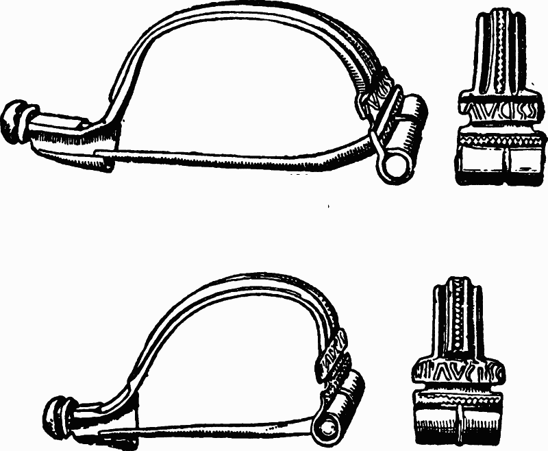
Fig. 98. Two Bronze Fibulae found at Charterhouse
(1) ΛV[symbol]SS or ΛVCISS (2) IIIΛVCISS
Copied by myself and published Archaeological Journal, lx. (1903), 240, lxii. 265. The readings seem fairly clear. In (1) the letters are so close that I am not sure if [symbol: reverse D] or CI should be accepted, but CI is meant in either case. In (2) the first three strokes are ornament: there are also two slender strokes shown in the cut which seem accidental.
The Aucissa type of fibula is shown best by the accompanying cuts. Its features are a hinge instead of a spiral coil to work the pin, and a flat semicircular bow, widest above the hinge and decorated only by lines or beading running lengthwise. It occurs widely throughout the Roman Empire and even beyond it. Some thirty specimens are known which bear the name Aucissa: a few bear other names, and a vast number are uninscribed. They seem to belong chiefly to the Augustan period and the years immediately following: occasional specimens are found with remains assignable to the second half of the first century. See further my articles cited above.
(18) One of four small leaden roundels, barely an inch in diameter, bears the inscription
CΛTV
It is possible that the lettering may have been transferred from a bit of Samian. The Lydney Collection contains a small piece of lead inscribed DOCCIVSI—wrongly included by Hübner among the pigs of lead—which appears to have got its inscription similarly from an ordinary Samian stamp. The roundels were found at Charterhouse and are now at Bristol Museum in the Pass collection, where I have examined them.
(19) Four lead weights in the Pass Collection, marked respectively:—
Copied by myself: the standard is obvious. Drawings of these, by the late J. T. Irvine, are in the Library of the Society of Antiquaries.
(20) Four lead weights, in the Taunton Museum, stamped:—
II about 19½ oz. avoirdupois.
III 3 oz.
S 5¾ oz.
V[symbol] 11 oz.
Copied by myself and published Arch. Journ. xlix. 186.
(21) Some stamps on Samian pottery are preserved in Taunton Museum:—
OFLCVIRIL. inside a fish-shaped label, broken at the end.
OF PATR
ROPVS' FE (Corpus Inscr. Lat. xiii. 10010, 1654).
A. POL. AVSTI
CRISPI
OF SILVINI
GENITORI[symbol]
SILVANI
[symbol]IIATICIOF (? Asiatici officina).
ΛISII. M (Corpus Inscr. Lat. xiii. 10010, 72).
OF. COTTO
CRISPINI. M
CRI[symbol]PV[symbol] (?)
M. MON (?)
PATE. . .
PRIVAT. .
REDITI. M
TITVRONIS
One pelvis has the mark I[symbol] II. V (Bath Field Club, iii. 341, not quite correctly given).
6. THE ROADS
The Roman roads in Somerset are few and easily described. Two roads led to Bath from the north-east and east, one from Cirencester and the Midlands, and the other from London, Silchester and Marlborough (Cunetio). Two roads equally led out of Bath to the west and the south-west. The former gave access to the neighbourhood of Bristol and the Severn ferry to South Wales. The latter ran through east Somerset and passed on by way of Chard, Axminster and Honiton to Exeter. Another road diverged from the Fosse at Ilchester and led to Dorchester (Durnovaria). And yet another, of which only a fragment can now be traced, served in some way the Mendip lead mines. This completes the list of certain roads. The doubtful ones are naturally more numerous. Two of these are not improbable, though they have not yet been proved. One—perhaps the best known and best supported—is supposed to have run from Salisbury (Sorbiodunum) along Mendip to Uphill and an alleged harbour on the channel. The other, which also has some claims to credence, is thought to have started at Glastonbury or Street, and, passing through the Somerton group of villas, to have joined the Fosse at Ilchester. Other roads have been conjectured which are far less probable than these. Roads indeed are the department in which Romano-British antiquaries have always exercised the greatest licence. It will be necessary to notice only two of these improbable roads.
(1) THE ROADS TO BATH FROM THE EAST AND NORTH-EAST
The two roads which approach Bath from the east and north-east demand few words. The course of each is well known. The northeastern road, coming from Cirencester, enters the area of the county a couple of miles north of Batheaston. It runs along the top of Bannerdown on the line of the modern high road and parish boundary, descends the hill by a steep straight drop down Morris lane—which is also followed by the parish boundary—and reaches the bottom of the valley near the third milestone from Bath. The eastern road descends Bathford (or Farley) Down—where its paving was noticed in 1882 (fn. 114) — passes along the north of Bathford village and joins the other road at the same third milestone. Hence the combined roads run, first northwest and then south-west, into Walcot, along a line exactly represented by the modern London road. In Batheaston the Roman metalling is said to have been found underlying the modern roadway.
As is well known, the north-eastern road has been called, since Anglo-Saxon times, the Fosse. That is also the name of the Roman road from Bath to the south-west and Exeter. It is natural, indeed, to think of these two roads which run continuously in the same general direction, as one through route, on which Bath is only an intermediate station. The Saxons obviously so regarded it. (fn. 115) It does not, however, follow that the Romans thought thus. They may have connected the road from Bath to Exeter with the road from Bath to London just as much as with the road from Bath to Cirencester. I have therefore preferred to treat the Fosse north-east of Bath separately from the Fosse south-west of it.
A piece of road which, if established, would supply an alternative to a portion of the eastern road, has been thought to run from Monkton Farley down Bathford Hill to the south of Bathford village, cross the Avon near Warleigh Ferry, climb Bathwick Hill, recross the Avon near the Pulteney bridge, and enter the Roman settlement by its east gate. It is admitted, however, by Mr. Scarth, that "this can only be discerned by the interments which have been found" in Bathwick, and the road has yet to be proved. A part of it, however, is probable enough. The group of remains, sepulchral and other, which occurs at the foot of Bathwick Hill near the Sydney Gardens (pp. 263, 266) indicates some village or suburb. This must have had communications with Aquae, and one of these communications may have led across the Avon to the east gate of the settlement. But apart from this, the suggested road has practically no evidence in its favour. (fn. 116)
(2) THE ROAD FROM BATH WESTWARDS TO THE SEVERN CROSSING AND SOUTH WALES
This road may, for convenience, be said to start from Bath. But it seems to have been regarded in Roman days rather as a continuation of the route from London, than as a road from Bath to the west. It does not, strictly speaking, start from Aquae. It diverges from the Fosse at Walcot church, half a mile east of the Roman settlement, and runs on westwards without entering the Roman area. Through modern Bath its course is roughly represented by Guinea Lane and Julian road. In Victoria Park it may have been joined by a road from the west gate of Aquae. But the evidence for such a road is scanty. It does not include any trace of an actual roadway and rests mainly on the probabilities of the case. Thence our road continues through Weston, mounts the neck of high land which joins Kelston Round Hill to Lansdown, runs close beneath North Stoke (p. 302) and drops sharply to the Avon valley and the 'station' or village at Bitton. West of Bitton, it coincides for some distance with the modern high road; then, skirting the north-east of Bristol, it crosses Durdham Down, where it has been excavated, sinks once more into the river valley and ends where the Trym flows into the Avon at Seamills. (fn. 117) Here was an important 'station.' It was first detected in 1712. Since that date, foundations of buildings, tiles, bricks, coins ranging from Republican times to Honorius, an inscribed tombstone (SPES C SENTI), and an immense number of small objects of all sorts, have been found in ever increasing abundance over an area stated (perhaps too enthusiastically) to extend to 50 acres. (fn. 118) Here, we may feel sure, began the trajectus or ferry to Caerwent and Caerleon and South Wales. We need not seek it at Aust Cliff or Portishead, or any other point on the Severn shore where neither abundant Roman remains nor Roman roads have been discovered.
This road is part of the Itinerary route from London to Caerleon. In the Itinerary it is described as follows:
| Isca (Caerleon) to Venta Silurum (Caerwent) | ix miles |
| Venta to Abone | xiv miles |
| Abone to Traiectus | ix miles |
| Traiectus to Aquae Sulis (Bath) | vi miles |
It would at first sight seem natural to identify Traiectus with Bitton and Abone with Seamills. This solution, however, raises serious difficulties. Seamills is indeed not much more than nine miles from Bitton. But Bitton is ten or eleven, not six, Roman miles west of Bath, and no 'station' except Bitton exists on this part of the route. Again, no 'traiectus' worth the name occurs near Bitton nor indeed anywhere on the route except at the crossing of the Severn. The first difficulty can be solved by supposing a corruption in the text, and reading xi. for vi. The second has caused much perplexity. The remedy most often suggested is to transpose Abone and Traiectus, making Abone the name of the village at Bitton, which is within half a mile of the Avon, and identifying Traiectus with Seamills. Perhaps it would be better to suppose that Abone is Seamills and that Traiectus was put against it in the Itinerary: the double entry then was by error extended into two lines and Traiectus extruded the name corresponding to Bitton. In that case the original Latin text may have been:
| (ab Isca) Venta Silurum | mpm viiii |
| Abone, Traiectus | mpm xiiii |
| " (Bitton) | mpm viiii |
| Aquae Sulis | mpm xi |
This view has the advantage of avoiding a transposition such as is not very common among the errors of the Itinerary MSS., while the mistake which it assumes, occurs often enough in lists of names of any sort.
The road is often called the Via Julia, and that name has been adopted in Julian Road at Bath and elsewhere along its course. It rests however on a mistake. Since Leland and Camden, antiquaries have been wont to support it by a couplet from the "De laudibus divinae sapientiae" of Alexander Neckam, abbot of Cirencester from 1213 to 1217. (fn. 119)
Intrat et auget aquas Sabrini fluminis Oska praeceps: testis erit Iulia strata mihi.
And hence Richard of Cirencester, that is, Bertram of Copenhagen, in the eighteenth century invented the name Via Julia for the whole road from Bath to Caerleon. But it appears that the true reading of Neckam's line is not Iulia but vilia, and the whole theory therefore falls to the ground. It may be added that even if Iulia were the correct text, Neckam's words would still refer to Monmouthshire and not to Somerset or Gloucester.
(3) THE FOSSE, FROM BATH TO CHARD
This road is well attested and well known throughout all but the southernmost part of its course. For forty miles from Bath to Dinnington it usually coincides with existing roads and paths; for just two-thirds of that distance it provides a boundary for thirty-two parishes; it follows a significantly straight course and passes sites with significant names like Stratton, and it is mentioned under the title of 'Fos' in very early charters. We need not here describe in detail what is shown on any good map and what has been fully recognized by several generations of antiquaries. (fn. 120) South of Dinnington, however, the trail is fainter. The Fosse here climbs the high range of Windwhistle Hill, towards which it has pointed since Ilchester, and its course is obscure. Probably it is represented by one of the deep lanes in Dinnington village; then it may follow Nash Lane and Fisherway Lane, and descending from the hill to Street, enter and pass down the valley of the Axe by Titherleigh towards Axminster. (fn. 121) Its whole course seems to have been laid out by sighting on to certain elevated points, such as Beacon Hill on Mendip, Easton Hill near East Pennard and the summit behind Dinnington. This method was no doubt usually adopted by the Romans in constructing their roads. But it is more recognizable than usual on the line of the Fosse in Somerset.
The Fosse has been cut through several times. Early in the nineteenth century Skinner trenched it near Radstock, and found at the bottom 'a layer of large flat stones, then a foot and a half of earth and rubble, above that a course of small stones, with pavement or pitching stone on the surface.' (fn. 122) More recently it has been examined in the same neighbourhood by Mr. McMurtrie. It was found to measure at the top about 7 feet in width, at the bottom 11 feet, and to be about 3 feet thick. On either side were well-marked ditches. Six layers of metalling were discerned. They were as follows, in ascending order: (1) a bed of soil, (2) a layer of rubble stones thickest in the centre, being there 5 inches deep, (3) a bed of 'concrete,' 15 inches deep, consisting of broken stones of local oolite and lias mixed with lime, (4) a layer of finer material, 10½ inches deep in the centre, made of local stone pounded fine and mixed with lime, (5) a course of paving stones of various sizes and shapes, put together as random work and cemented with lime. On this fifth layer the ruts of wheel tracks were discernible, 2 feet 9 inches apart. (fn. 123) With this description we may contrast what Stukeley said he saw, nearly two centuries earlier, on another part of the road. South of Ilchester he observed the road 'pav'd with the original work: 'tis composed of the flat quarry stones of the country, of a good breadth, lay'd edgwise, and so close that it look like the side of a wall fallen down.' (fn. 124) This paving may be later than the Romans.
(4) ILCHESTER TO DORCHESTER
This branch road needs no comment. It can be traced fairly continuously, leaving Ilchester on the line of the modern Yeovil road, passing west of Yeovil through lanes and fields, and then falling again into the modern high road to Dorchester. (fn. 125) It forms occasionally but not commonly a parish boundary, and few significant names occur along its course. But its straightness between two certain Roman sites seems to prove its Roman origin. Phelps states that its raised track was visible in many fields and that it was formed of flints brought from the neighbouring chalk downs.
(5) ROAD CONNECTED WITH THE MENDIP MINES
A fragment of Roman road—not, I think, hitherto noticed—can be traced on the north side of Mendip. It is only three or four miles long, and runs north-east and south-west, dividing the parishes of West Harptree and Compton Martin. It is attested by its straightness, its coincidence with parish boundaries, and the name Stratford Bridge. It was, I imagine, connected in some way with the Mendip lead mines. To judge by the parish boundaries, one might think that it climbed the steep scarp of Mendip and continued a mile or so along the plateau, till it met the line of the supposed Ad Axium road. (fn. 126)
(6) THE AD AXIUM ROAD
This road was first noticed by Sir R. C. Hoare, who made an elaborate survey of it on the surface. According to him, it ran from Salisbury westwards through Maiden Bradley, climbed Mendip near its eastern end, crossed the Fosse on Beacon Hill, skirted the preRoman camp at Maesbury, and passed on straight north-westwards to Charterhouse. From here its course lay along the south side of Blackdown to near Shipham, then along the south side of Banwell Hill, and straight on over Bleadon Hill to Uphill and an alleged harbour at the mouth of the Axe. Its total length would be about 55 miles. (fn. 127)
I must confess to some scepticism concerning this road. Its actual traces are very scanty. Even Sir R. C. Hoare admits that large gaps impaired the continuity of the surface vestiges which he thought to detect. As laid down by him, it rarely coincides with any straight existing road, and still more rarely with any parish boundary. Between Salisbury and Charterhouse, a distance exceeding forty miles, it passes hardly any inhabited Roman site, and no village or town. Its supposed objective, the harbour at Uphill, rests on scanty finds of late coins (p. 368). I have carefully examined the supposed line of the road from Greenore on Mendip to Uphill, and have found no vestiges, even in ploughed fields and woods, that indicate a Roman road. The problem could be solved by excavation; without it the road seems to me to be unproven. The name 'Ad Axium' is in any case a modern invention.
(7) ILCHESTER TO STREET (OR MENDIP)
A road is often said to have branched off from the Fosse at Ilchester and run north-westwards through the Somerton villa district to Street, and perhaps to the Mendip mines. Its course has been laid down, principally, I believe, on the authority of Mr. S. Hasell, who excavated the Somerton villas. (fn. 128) But the available evidence, for it is scanty. The most definite remains that can be connected with it is an old corduroy road found in the moor north of Street, and close to Street church. The name of Street, if ancient, is significant, and Roman potsherds have been found in its churchyard. (fn. 129) But the road itself may be connected with Glastonbury Abbey quite as probably as with the Romans, and the rest of the supposed route shows even smaller traces of antiquity. In default of a critical examination, it must be called unproven.
(8) ALLEGED ROADS
(i) Bishop Clifford tried to trace a military road from Exeter to Caerleon. (fn. 130) He urged the evidence of the Antonine Itinerary, and the existence of suitable stations at Hembury Fort in Devonshire and at Taunton. But the passage of the Antonine Itinerary which he quotes is known to be interpolated ; Hembury Fort is certainly not Roman, and the remains at Taunton are not only too few to prove a Roman station, but include nothing that indicates a roadway. (fn. 131) Moreover, Bishop Clifford admitted that no traces of the road have ever been found. It must be added that his theory of a military, as distinct from a commercial road, is untenable ; and his idea that 'the twelfth Itinerary connects together all the great forts in the south and west of Britain' assumes forts at many places where we have no traces whatever of permanent Roman garrisons.
(ii) No better evidence exists for another road alleged by Phelps and other writers to have run from Ilchester through Sparkford, Galhampton, Redlinch Park and Kingston Deverill to Old Sarum. This appears to be a transmutation to Roman times of a British trackway supposed by Sir R. C. Hoare to have joined Ilchester and Old Sarum (Anc. Wilts, Roman Aera, p. 40). There does not appear to be any real reason for accepting either Roman or British road here.
7. MISCELLANEOUS FINDS
We have now surveyed all the well-attested remains in Somerset which indicate permanent inhabitation of definite places during the Roman period—the spa at Bath, the villages at Camerton, Ilchester and perhaps Ham Hill, the villas, the Mendip mines, the roads. There are left to be noticed a great number of discoveries, or alleged discoveries, which do not seem to suggest such permanent occupation. Some of these consist of objects, due probably to chance, such as isolated coins or potsherds accidentally lost or thrown away by some one passing. Others may belong to inhabited sites which our ignorance prevents us from recognizing as such. Others again are uncertain in age or in character, and demand notice rather because they have been styled, than because they actually are, Roman. All these can most conveniently be treated in a bibliographical list.
But it may be well to shorten this list by first noticing separately two special groups of finds. These cannot be classed under any of the preceding sections of this article. They demand fuller notice than suits an index. They have also—though this is an accident—a certain connexion in subject.
(a) REMAINS FOUND IN THE MARSHES ROUND THE POLDEN HILLS
The Polden Hills form a long thin ridge of upland, 200–300 feet above sea-level, which runs east and west between the neighbourhood of Glastonbury and that of Bridgwater, and divides the marshes of the Brue from King's Sedgemoor. Striking remains of both the British and the Roman periods have been found near their western end. We are here concerned only with the latter.
These remains do not include any very definite traces of dwellings. Perhaps there was a villa at Bawdrip, but it is not certain, and the villas ascribed to Chedzoy, Woolavington and Edington have, I think, no real evidence to prove them. (fn. 132) We have here to deal with a different kind, or rather two kinds, of remains. The first of these are coinmoulds made in clay, of which great numbers have come to light. In 1670, as Paschal writes to Aubrey, 'several hundreds of casting-moulds of fine clay' were found three or four feet deep, in low ground, on a site not easy to identify, but probably near Bawdrip, on the south side of the Polden Hills. The moulds bore the heads and names of Severus, Caracalla, Julia and Plautilla. Paschal sent a 'boxful' to the Royal Society, and Aubrey gave twenty to the Ashmolean Museum in Oxford, but both donations have disappeared. (fn. 133) A second discovery was made in 1801 on the north side of the Polden range, in digging a drain, a quarter of a mile north of the village of Chilton, in low ground on or near the Nidons. Here the Rev. J. Poole picked up some hundreds of moulds in a space of four feet square and at a depth of some nine inches. They bore the heads of Severus, Julia, Caracalla, Plautilla, Geta, Macrinus, Elagabalus, Severus Alexander, Julia Paula, and Mamaea. (fn. 134) More finds followed in 1835 in the same marsh, and probably about the same spot, between Chilton village and Edington Burtle—moulds bearing the heads of Commodus, Severus, Julia, Caracalla, Geta, Mamaea, and Severus Alexander, and two actual coins of base (apparently white) metal, one of Severus, and the other of Geta. (fn. 135) Yet a fourth discovery, of which fewer details are recorded, was made in Highbridge in 1804. Seven feet deep in the alluvial deposit, workmen who were excavating new drainage channels, found a layer of hard peat, and, lying upon it, Roman potsherds, bricks suggestive of kilns and several moulds for casting coins. (fn. 136) Lastly, an illegible mould preserved in Brighton Museum is said to have been found at 'Pointing Hill, near Bridgwater,' though its other history is lost.
Similar discoveries of clay moulds for casting coins have occurred elsewhere in Britain and in other parts of the western empire, Gaul, Germany, Noricum and Africa (Tunis), though apparently not in Italy or the east. They occur both in large towns and in remote and lonely places.
The period when they were principally made and used seems to have been that dark age of the Roman currency from about a.d. 210–280. The majority of the specimens bear the heads of Septimius Severus, his sons Caracalla and Geta, or their successor Elagabalus ; some show later emperors of the third century, while a few represent those of the second century or of the first half of the fourth century. Almost all appear intended for casting either denarii, and especially the debased denarii current in the third century, or bronze folles of the early fourth century. (fn. 137) Several theories have been advanced as to their use. They have been attributed to forgers, They have been attributed to the Government, attempting by travelling mints to supply local deficiencies in currency for the use of soldiers and traders. They have, thirdly, been ascribed to private coiners working to the same end with the sanction, or at least the acquiescence, of the State. Of these three origins the first is the most generally probable, and it alone is applicable to our present case. We can imagine forgers plying in the secret and lonely marshes of west Somerset. We cannot imagine the State sending thither a travelling mint, or private coiners, other than forgers, selecting the spot. Evidence, moreover, is wholly wanting which might prove that either travelling mints or authorised (or tolerated) private coiners really existed. Both are hypotheses, invented to suit the views of special writers. Both, so far as I can judge, are quite unnecessary. (fn. 138)
The coin moulds are not the only Roman remains in this district. On the north side of the Polden Hills the parishes of Edington, Chilton, Catcott, Cossington, Huntspill and Shapwick contain on their lower levels numerous small mounds, oval or round in shape, various in size, which rise up out of the marsh much like barrows on a flat plain. Many of these mounds were opened by Mr. W. Stradling in the early years of the nineteenth century. They proved to consist largely of fragments of Roman black ware, while near them were discovered platforms of clay and rude bricks lying thereon. These bricks resembled those used in kilns to keep earthenware in place during the process of firing. The finder accordingly took the platforms to be relics of kilns and the mounds to be refuse heaps of vessels damaged in the baking. Once or twice scoriae of iron or coal suggested ironworking, but the vast majority of the remains were pottery, and in some cases the pottery mounds and coin moulds were discovered side by side. (fn. 139)
A few other relics indicate Roman occupation here. In particular Mr. Stradling in 1838 found two small leather purses in a pottery mound. The one contained the smallest silver coins of the later Emperors and the other the smallest copper of the same era, and among the latter was a coin of Flaccilla, wife of Theodosius I. Constantinian coins have also come to light in the marsh at Shapwick and a fibula at Moorlinch. (fn. 140) In sum, we have proof that in Roman days man really dwelt on the edge of the marsh that skirts the Polden Hills. The occupation may have been confined to the third and fourth centuries. The occupants may have been few and shy and retiring. But they deserve a moment's consideration ; for they belong to one of those secluded corners of former life which in every period of history are so hard to approach and comprehend.
(b) HOARDS OF LATE SILVER COINS
Numerous hoards of Roman coins have been discovered in Somerset. Most of these require no special notice and can be treated sufficiently in the index. But one remarkable feature is provided by an unusually large number of hoards of late silver coins, minted in the fourth century and buried or lost at dates near or even after its close. The reason for the occurrence of such hoards in the remote west is not clear. They are not in general common in England. Only one has been found in Worcestershire, one in Berkshire, none in the adjacent counties of Devon and Cornwall, and none in Warwickshire or Northamptonshire or Derbyshire, two in Hampshire (with three copper hoards of the same date) and two in Norfolk. Their distribution and metal, and, in some cases at least, their date forbid us to connect them with the march of Magnus Maximus on Rome in 387 or with the 'withdrawal of the legions' in 406. They seem to point rather to some special fortune or misfortune of Somerset about the beginning of the fifth century. (fn. 141) Such might be either attacks of Irish pirates or, at a later date, the retreat of the Romanized Britons from eastern Britain before the Saxons. But of the first we know so little that we can hardly use it safely, and the second appears to have come too late to explain coin hoards, in which many of the coins were certainly found in excellent preservation. It is, however, proper to add that while these hoards of late silver seem commoner in Somerset than in most parts of Britain, they are correspondingly commoner in Britain than elsewhere in the Empire. M. Blanchet, for instance, in his Trésors de monnaies romaines en Gaule, has no clear case to record of such a hoard in Gaul. Mommsen has observed (fn. 142) that, after about a.d. 360, silver was hardly used in the Empire for commerce, except in Britain. But he offers no explanation of the fact, and perhaps on our present imperfect statistics, it may be wise not to attempt one. The Coleraine hoard of 1506 silver coins (dating from a.d. 337–410 circa), silver ingots and other fragments may, of course, be connected with Irish pirates. But it is obviously due in the first instance to the use of silver coin in Britain, and must ultimately be explained by that fact.
(1) In making the Great Western Railway between Bath and Bristol, a hoard was found in 1839 at a spot which was intentionally concealed. It is said to have contained 250 silver coins; 150, which were examined, consisted of coins of Valens, Gratian and Magnus Maximus in about equal proportions. The mintmark was mostly Trier, and the reverses mostly 'Urbs Roma' and 'Virtus Romanorum.' (fn. 143)
(2) At Uphill, near Weston, a workman clearing rubbish in a cave in 1846 found potsherds and 129 silver and copper coins, mostly of Valentinian and Gratian. After the rubbish had been wheeled out of the cave, 'scores of these ancient coins' were further discovered lying mixed up with it. Over the place where the coins originally lay was a large fissure in the rock, and it was supposed at the time of discovery that the coins might have fallen through this. A coin of Julian and potsherds had been found in 1826 in this or a neighbouring cave. (fn. 144)
(3) A large hoard of silver coins was discovered about 1866 in the vicinity of Bristol or of Mendip at a spot which has not been revealed. The whole, or at least the bulk of it, to the number of 2,044 coins, is now in the cabinet of Sir John Evans, who has kindly given me the following analysis of it. The vast majority of the coins, 2,005, are ordinary siliquae; 32 are of the conventional medallion size, and 7 are small conventional quinarii. The emperors represented are:—
Of these coins, two of Magnus Maximus, with mint marks of London under its fourth century title of Augusta (AVG and AVG PS), are noteworthy. The three coins of Roma are ascribed by Sir John Evans to the period of Valentinian and come from the Trier mint. (fn. 145)
(4) A far more striking and far better recorded find occurred in 1887 in the parish of East Harptree, near the summit of the north escarpment of Mendip, 800 feet above sealevel, close to the Frances Plantation and some three miles east of the Charterhouse mining settlement. The find was contained in a pewter vessel, 10¾ inches high, provided with a handle and exemplifying a shape not uncommon in the late Empire. The objects contained in this vessel were (1) a silver ring set with a cornelian intaglio of Mars; (2) five small ingots of cast silver weighing respectively 818, 808, 644, 516, and 248 grains, and 1496 or more silver coins in excellent preservation. These coins were:—
| Constantine I | 1 |
| Constans | 4 |
| Constantius II | 340 |
| Decentius | 1 |
| Julian | 718 |
| Jovian | 8 |
| Valentinian I | 165 |
| Valens | 199 |
| Gratian | 60 |
To these I may add 1 Constantius Gallus (66 grains), 1 Valentinian (68 grains) and 1 Valens (65 grains), medallions, shown me by Professor Oman and believed to be waifs from this hoard.
Of eleven mints represented, Arles sent 553 coins, Lyons 574, and Trèves 207, while the distant mints, Antioch, Constantinople, Nicomedia, contributed only 30. The coins were of three sizes. Most were small siliquae of 31–33 grains; 8 averaged 49 grains, and 15 were medallions or double siliquae of 66 grains, coined largely in the distant mints. (fn. 146)
(5) Not long before 1859 an urn with a hoard of mixed silver and copper coins was found just outside or in the entrance to Wookey Hole. No proper account of it exists. But it seems certain that amongst the silver were issues of Constantius II, Julian, Valens and Gratian, and in particular a medallion or double siliqua of Gratian. The copper coins are said to have included small brass of the Constantine family, Valens, Valentinian, and Gratian and perhaps others. (fn. 147)
(6) In the marshes near Edington and Chilton Mr. W. Stradling discovered in a pottery mound (p. 353) two leather purses. One contained the smallest silver of the later Empire, and the other the smallest copper of the same age, including a coin of Aelia Flaccilla (died 388).
(7) At Holway, a south-eastern suburb of Taunton, a large hoard of late silver was found in 1821, and a few waifs from it (as it seems) were picked up in later years. No proper record was kept. It is said to have been stored in a Samian jar and to have ranged from Constans to Honorius and Arcadius. Like the Harptree hoard, it included many medallions or double siliquae—2 Constans, 2 Julian, 10 Valentinian, 4 Valens, 7 Gratian, 2 Valentinian II, 1 Magnus Maximus, 4 Theodosius and 1 Eugenius—mostly coined in eastern mints, and perhaps others not precisely recorded. Besides these, there was a much larger number of small silver siliquae of about the size of a sixpence or fourpenny bit. (fn. 148) See further p. 363.
(8) At North Curry, a village in the low country six miles east of Taunton, an urn with about 150 silver coins was ploughed up in July 1748. The coins were of Constantine, Constans, Julian, Valentinian, Valens, Gratian, Theodosius, Magnus Maximus, Honorius and Arcadius. One Gratian was of the size of a shilling—a medallion or double siliqua; the rest were about the size of a sixpence or fourpenny piece. (fn. 149)
I may here add a tiny hoard noted on p. 292, and two hoards of the same date as the preceding, of which the metal is not recorded.
(a) At Milverton, six miles west of Taunton, a hoard was found in an urn about 1847. Only 45 coins are recorded, and apparently no more were discovered.
| Julian | 3 |
| Valentinian I | 3 |
| Valens | 7 |
| Valentinian II | 2 |
| Theodosius | 6 |
| Theodosius Maximus (sic) | 16 |
| Arcadius | 1 |
| Faustina (sic) | 7 |
Faustina must be an error for Fausta, and Th. Maximus may be an error for Magnus Maximus. (fn. 150)
(b) 40 coins ranging from Constantius II to Gratian and Theodosius, discovered about 1846 near a Roman villa found by Mr. S. Hasell near Charlton Mackrell (villa No. 36 above).