Survey of London: Volume 46, South and East Clerkenwell. Originally published by London County Council, London, 2008.
This free content was digitised by double rekeying. All rights reserved.
'Charterhouse Square area: Introduction; Charterhouse Square', in Survey of London: Volume 46, South and East Clerkenwell, ed. Philip Temple (London, 2008), British History Online https://www.british-history.ac.uk/survey-london/vol46/pp242-265 [accessed 1 May 2025].
'Charterhouse Square area: Introduction; Charterhouse Square', in Survey of London: Volume 46, South and East Clerkenwell. Edited by Philip Temple (London, 2008), British History Online, accessed May 1, 2025, https://www.british-history.ac.uk/survey-london/vol46/pp242-265.
"Charterhouse Square area: Introduction; Charterhouse Square". Survey of London: Volume 46, South and East Clerkenwell. Ed. Philip Temple (London, 2008), British History Online. Web. 1 May 2025. https://www.british-history.ac.uk/survey-london/vol46/pp242-265.
In this section
CHAPTER IX. Charterhouse Square Area
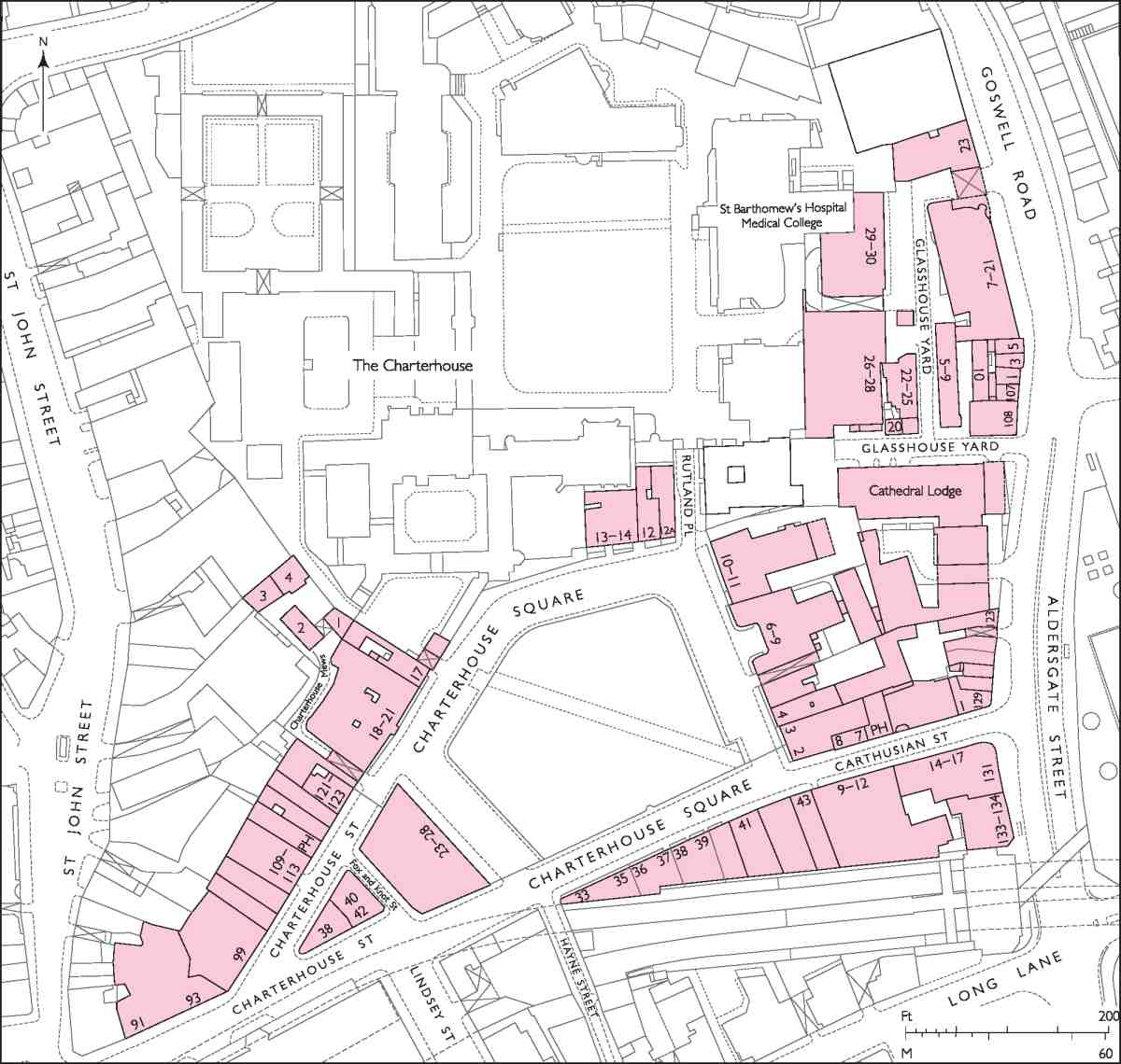
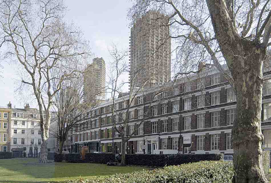
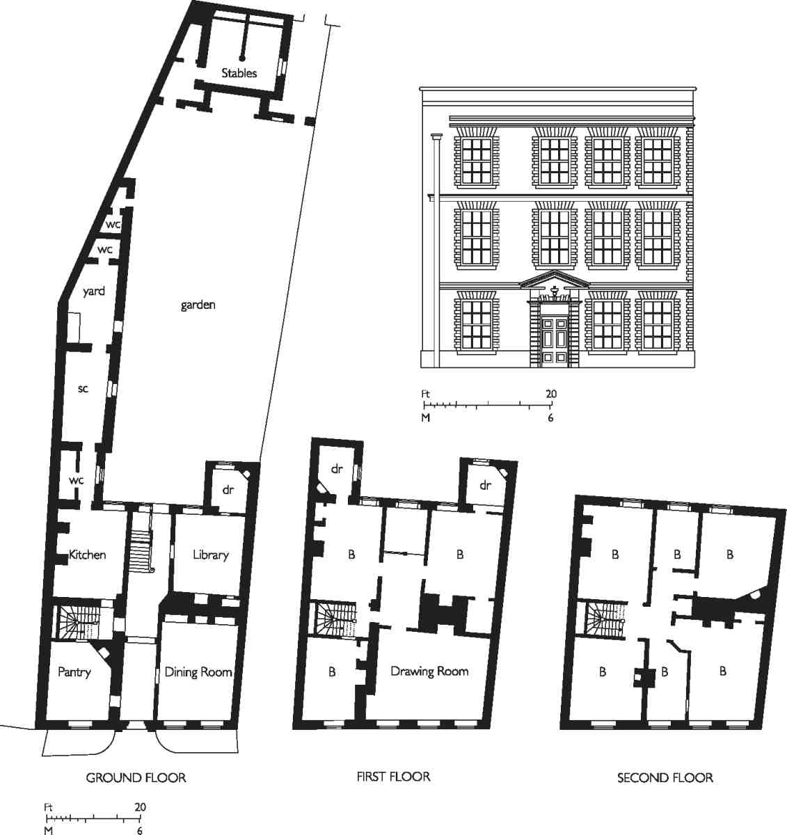
331. Charterhouse Square area
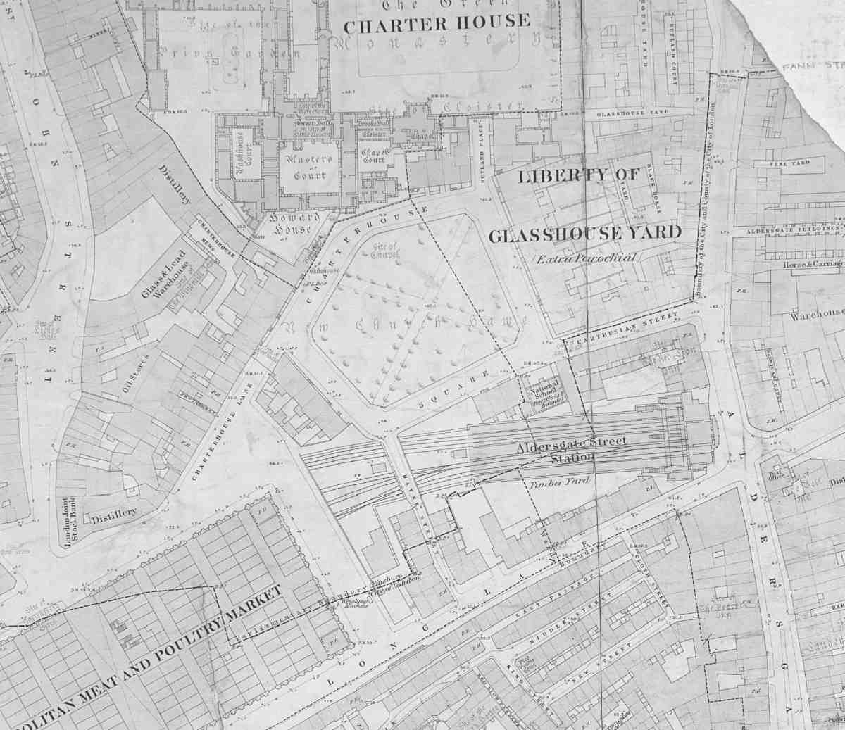
This chapter covers a district centred on Charterhouse Square, extending westwards towards the edge of Smithfield Market and eastwards to the line of Aldersgate Street and Goswell Road (Ill. 331). With a few small exceptions, the area falls just outside the northern boundary of the City of London, within the modern Borough of Islington. None of it ever formed part of the historic parish of Clerkenwell with which this volume is principally concerned. It is included because it belongs to the narrow belt of land between that parish and the City, like the Cowcross Street area adjacent (Chapters VII and VIII). By the time of Ogilby & Morgan's map of 1676 at the latest it had been divided between two jurisdictions, whose boundary ran north—south through the middle of Charterhouse Square. The western portion belonged to St Sepulchre without Newgate, in other words the part of St Sepulchre's parish outside the City. The eastern portion belonged to the parish of St Botolph without Aldersgate, but between the early eighteenth century and 1900 it was separately administered for civil purposes as the Liberty of Glasshouse Yard. (fn. 1)
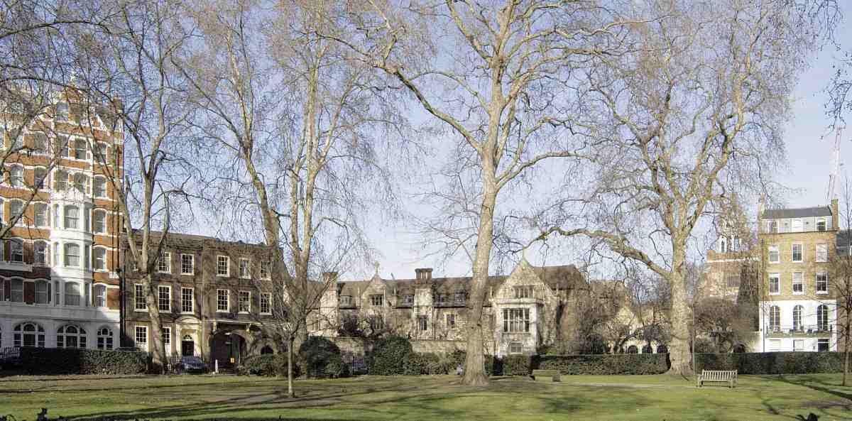
The history and character of this area have been dominated by the august presence of the Charterhouse (Ill. 336), a separate study of which will be published as a Survey of London monograph. The Charterhouse was founded as a Carthusian priory in 1371, became a private mansion after its dissolution in 1538, and in 1611 was converted for charitable purposes as 'Sutton's Hospital in Charterhouse', in which use it continues today. What is now Charterhouse Square belonged to the priory's outer precinct, acting as a buffer zone between it and the City. The main entrance to the Charterhouse was always from the arched gateway still extant on the square's northern side (Ills 337, 358). Here, too, remnants of medieval wall delimit the old boundary between outer and inner monastic precincts, while glimpses of the Charterhouse can be had beyond.
To this day the Charterhouse has kept its ancient impenetrability. That is mirrored in milder degree by Charterhouse Square, which with its unadopted roadways, its gates in three corners and its smattering of old houses partakes of the air of a cathedral close, at one remove from urban bustle nearby. The sense of a backwater would have been stronger before 1874, when the square was opened up to through traffic by the eastwards extension of Charterhouse Street, to join up with the south side of the square and Carthusian Street. Prior to that the only way into the square from the east was the controlled and gated Charterhouse Lane (now a branch off the main line of Charterhouse Street).
The following chronological survey of architectural and social development in and around the square since the Reformation is succeeded by accounts of the square itself, and the other streets and sites in approximate topographical sequence from west to east.
Chronology
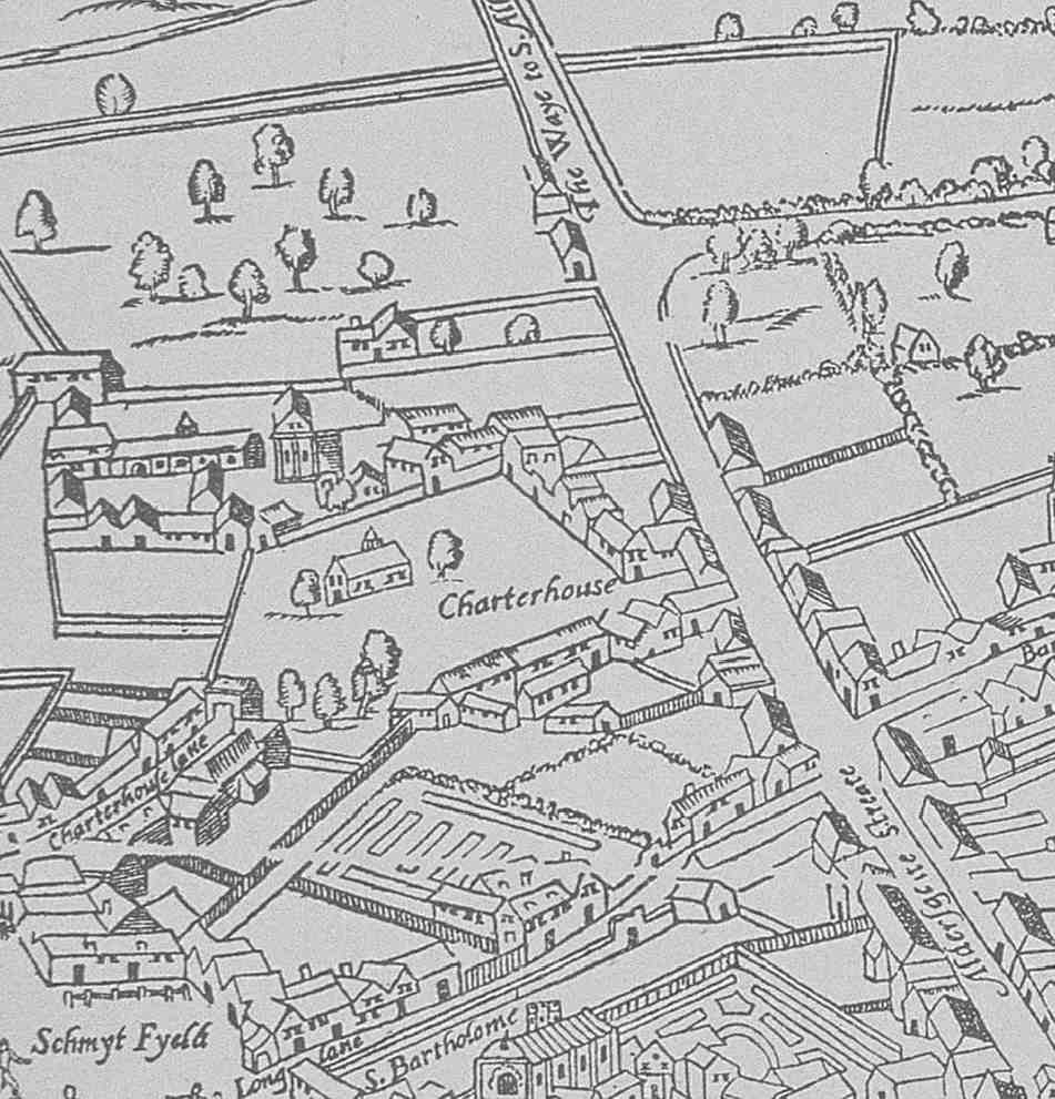
At the Dissolution much of the outer precinct of the Carthusian priory remained open ground. The present garden of the square, commonly known as the Charterhouse Churchyard and marked on some maps as 'New Church Hawe', is attested as a Black Death burial ground. During trial excavations in 1998 fewer burials were found than expected. This may be because many were removed in 1834, when as later reported 'vast numbers of bones and skeletons' were discovered during sewerage works. (fn. 2) A chapel dedicated to the Virgin Mary and All Saints stood hereabouts until 1615–16; the 'Agas' map of c. 1562 (Ill. 332) depicts it not far from the priory entrance. The map shows the open space as an irregular pentagon, corresponding to the outline of the present square. Around its edges the east and south frontages are almost entirely filled with buildings, but much of the west side is unoccupied. Sections of the frontages without buildings appear to be walled.
As before the Reformation, gates then controlled the eastern approach from what is now Carthusian Street and the western approach from Charterhouse Lane. The 'Agas' map suggests the Carthusian Street gatehouse had a pitched roof but shows no other details. It had been replaced by 'a turnpike on a rail' by the mid-seventeenth century. (fn. 3) The Charterhouse Lane gatehouse survived until 1775. Here there were upper rooms used as accommodation for the matrons of the Charterhouse school until 1656, and then for its porter. (fn. 4)
Before the eighteenth century the open space was variously described as the Charterhouse precinct, Charterhouse Yard or Charterhouse Close as well as Charterhouse Churchyard. Its freehold ownership, together with the chapel and the gatehouses, passed along with the Charterhouse itself to Lord North in 1545 and the Duke of Norfolk in 1565. (fn. 5) These external properties were not specifically referred to in the deed of sale of the Charterhouse to Thomas Sutton in 1611. But in the late seventeenth century the governors of Sutton's Hospital successfully asserted that they were the owners 'in the right of the said hospitall of the Soile & Grounds of the Charterhouse Church yard commonly called Charterhouse yard'. (fn. 6) The issue was of some moment, since the Charterhouse itself remained extra-parochial after the Reformation. Although its former outer precinct lay in the parishes of St Sepulchre and St Botolph, it was deemed to be within the jurisdiction of the freeholder of the Charterhouse. During the Duke of Norfolk's ownership, it was explained that only he and his officers 'do make Arests and serve all the Queenes processe within the Church yard there and none other to enter'. (fn. 7)
332. Extract from the 'Agas' map of the 1560s. Charterhouse Square (or Yard) in centre, labelled Charterhouse; buildings of the Charterhouse above and Aldersgate Street to right
By contrast, ownership of the buildings surrounding the yard became fragmented after the Dissolution. At least one of the larger properties here had already been leased by the priory to laymen. In 1532 Sir John Neville, Lord Latimer, took a lease of a mansion at the east end of the churchyard, formerly held by the Abbot of Pershore. (fn. 8) The Tudor fragments that survived at No. 10 Charterhouse Square until the Blitz probably belonged to this house. Latimer married Katherine Parr—after his death in 1543 Henry VIII's sixth queen—and her brother William Parr is also supposed to have lived in the yard. Other members of court circles among tenants or lessees of buildings hereabouts in the aftermath of the Dissolution included Sir John Williams, Keeper of the King's Jewels; Robert Burgoyne, one of the auditors of the Court of Augmentations; Bartholomew Westby, Baron of the Exchequer; Sir Arthur Darcy, one of the King's servants; and John Leland, the topographer and 'King's Antiquary', recorded at a tenement adjoining Lord Latimer's mansion between 1538 and 1546. In 1545 tenements in the neighbourhood of Charterhouse Yard were granted to John Bernard, another of the King's servants. These were 'Egypt' and 'Le Garneter', the monastery's names for its flesh kitchen—in biblical reference to the 'fleshpots of Egypt'—and granary. (fn. 9)
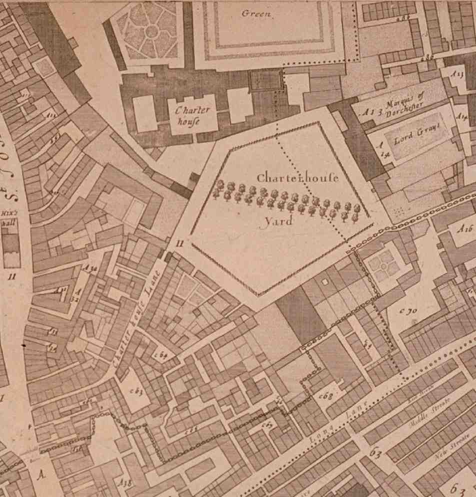
333. Charterhouse Square area from Ogilby & Morgan's map of 1676
The former precinct in the mid-sixteenth century therefore drew owners and residents of high status. That persisted for the next century and a half. Property here was doubtless attractive because of its proximity to the Charterhouse (which housed a succession of powerful and influential figures down to its sale to Thomas Sutton), its position at the edge of the City yet beyond the authority of the Corporation, and its protected seclusion.
In 1657 James Howell described Charterhouse Yard as containing 'many handsome Palaces, as Rutland House, and one where the Venetian ambassadors were used to lodge'. (fn. 10) Rutland House, the most important mansion, occupied the north-east corner. Its origins and history are bound up with with those of the Charterhouse, but the present buildings on the site fronting Charterhouse Square are dealt with in this volume. Behind it a large garden stretched northwards and eastwards until about 1660, on the site now represented by Glasshouse Yard. Other houses of quality were confined to the east and south sides of the square. On the south side, two large houses at the ends flanked a row of somewhat smaller houses. (fn. 11) On the west side continuous, shallow building is shown by Ogilby & Morgan's map of 1676 (Ill. 333).
Much of the eastern side was owned for many years by the aristocratic Heneage and Finch families and their con nections. Legal personages were among the prominent residents here. One, Sir Christopher Wray, was Lord Chief Justice under Elizabeth I. Another, Sir John Bramston, Lord Chief Justice of the King's Bench under Charles I, recorded that in 1635 'I took a house in the Charterhouse yard and fell to the practice of law'. In the Civil War period the area's border status, 'beinge as it were between London and Midlesex', served Bramston well: 'I escaped watchinges, sending out soldiers, and payment of taxes a longe tyme'. (fn. 12) Not all the smarter inhabitants were royalists. Sir William Waller, the future Parliamentarian general, was described as 'of the Charterhouse' in a list of those who came to the aid of Parliament in 1642. Like Bramston, he is supposed to have lived on the east side of the yard. (fn. 13)
334. Charterhouse Square looking south, engraved by Sutton Nicholls, c. 1728
Richard Baxter, the presbyterian divine, lived in a house hereabouts between his release from prison in 1686 and his death in 1691. A different character is conveyed here a century earlier by John Sinclair's bowling alley and dicing houses, noted in 1590 as 'a verie great Anoyance' because of the 'great resort of evell disposed persons who doe play there daye and night'. They were blamed for burglaries and for making it unsafe to pass through the yard after dark. (fn. 14)
Burglaries, reported again at aristocratic houses round the yard in 1602 and 1613, were not the only local anxiety. (fn. 15) Smithfield's proximity created problems, with cattle being driven through the yard from Aldersgate Street despite the gates. In 1715 the yard was alleged to be 'dayly annoyed with vast numbers of disorderly persons who teare down the Trees and fill it with noise and nastiness'. (fn. 16)
As its environs became more thickly populated, Charterhouse Yard began to change. Houses along the east and south sides were redeveloped and aristocrats gave way to bourgeois residents. A harbinger was the breaking-up of the Rutland House property after 1660, first by means of a glasshouse on part of the garden, then with a series of tenement developments built around Glasshouse Yard east of the Charterhouse garden. By the time of Ogilby & Morgan's map (Ill. 333) there were still private gardens between the yard and Aldersgate Street, but to the west along Charterhouse Lane as far as St John Street a dense warren of courts and alleys is shown.
335 (above). Charterhouse Square looking east, c. 1730

336. The Charterhouse and north side of Charterhouse Square, c. 1700, by Johannes Kip
337. North-west corner of the square after rebuilding c. 1720
The first change to affect the topography of Charterhouse Yard was the cutting-through in 1687 of the narrow street now known as Hayne Street on the site of a large mansion on its south side, thus connecting Long Lane with the yard (Ill. 334). The Charterhouse governors sought to recover their precinct's integrity by ordering the new street's closure. Instead, to mitigate the intrusion, it was gated and a porter's box placed near by. (fn. 17) Then between 1688 and 1705 redevelopment transformed all four sides, coinciding almost exactly with the reign of William and Mary. Some of this building was substantial in scale, as the four-storey survivors at Nos 4 and 5 Charterhouse Square attest (Ill. 335). Finally in 1716–18 building took place in the hitherto blank north-west corner of the yard next to the gateway into the Charterhouse (Ills 336, 337).
338. Charterhouse Square and the Metropolitan Railway in 1873, shortly before Charterhouse Street (left) was extended to the south side of the square
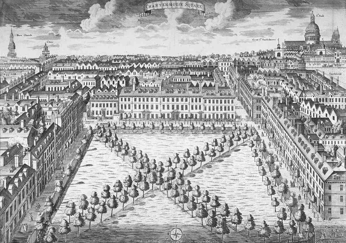
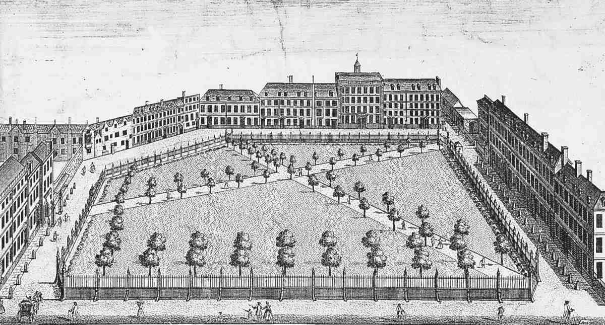
In 1708 Charterhouse Yard, still so called, was described as 'a pleasant place, of good, (and many New) Buildings'. (fn. 18) Peers had now vanished, leaving the rebuilt enclave thoroughly bourgeois. (fn. 19) Along with the change came collective responsibility. In both 1715 and 1742 residents took action to improve the open space, the latter initiative resulting in an Act of Parliament and the establishment of trustees. With the perimeter built up and the central garden fenced and laid out with crossing walks and low trees, the yard was transformed into the equivalent of a West End square. Topographical views of the 1720s (one made under the auspices of the printseller Henry Overton, who later owned the freehold of No. 35 on the south side) were the first to focus away from the Charterhouse itself, and indeed illustrated the enclave as 'Charterhouse Square' (Ills 334, 335). (fn. 20) Thereafter the older name faded away.
Despite the presence of two public houses in the 1760s, (fn. 21) eight merchants had addresses here by the middle of the eighteenth century, and there were soon more. Five clergymen are listed among the 35 householders in 1790. Early in the next century Robert Smythe, historian of the Charterhouse, could note with satisfaction that 'the inhabitants are of the most respectable description'. (fn. 22) With the advent of the Royal London Ophthalmic Hospital at No. 40 in 1805, and the proximity of St Bartholomew's Hospital, surgeons also began to find the square eligible. In the 1820s there were five of them and in 1842 eight. But by the latter date the buildings were increasingly being used other than as family houses, with three schools, two lodging-houses and an infirmary listed. Among the craftsmen were watch- and clockmakers and a goldsmith. (fn. 23)
The Victorian opening-up of the square followed hard upon the re-planning of Smithfield Market and the cutting-through of the railway (Ill. 338). In 1864–5 the Metropolitan Railway Co. bought the whole of the south side in order to construct an extension from Farringdon to Moorgate in a cutting immediately behind, where it built a station at first called Aldersgate Street, now Barbican. (fn. 24) Then in 1868, the year of the formal opening of its new Smithfield Market, the City Corporation opened negotiations to create a highway connecting it to Aldersgate Street via Charterhouse Square. (fn. 25) This road was part of a long, straight alignment planned to run west—east all the way from Farringdon Road to Aldersgate Street, passing en route along the north side of the market. The portion covered by this chapter, laid out in 1873–4, entailed the final clearing-away of the barrier in Carthusian Street. The whole thoroughfare west of the square was designated Charterhouse Street. Confusingly, Charterhouse Lane was renamed and numbered as part of the new Charterhouse Street, although what was left of it after clearance and reconstruction ran off from it at an angle.
The advent of the railway made property on Charterhouse Square's south side shallow and ineligible. The surviving houses were soon replaced by showrooms and warehouses occupied by milliners and clothiers. By the time of this change several houses in the square were already being used as staff hostels by wholesale clothing firms. Social deterioration was the consequence. In 1894 an inmate from No. 7 was found in a compromising position with a young woman on a bench in the square, and a watchman's box was knocked over one night 'by some roughs'. (fn. 26) In 1902 it was also complained that horse sales in Aldersgate Street led to horses being illegally 'tried' in the private part of the square. (fn. 27) That year saw the opening of the first purpose-built hotel in the square, the Charterhouse Hotel, to add to the hostels and commercial hotels in the old houses.
The square had by then lost its middle-class aura. Though several City parishes found it convenient to locate their parsonages there, the majority of private householders had gone. Most of the other buildings were occupied by businesses, with printing predominant. (fn. 28) On the eve of the Second World War, the printing industry had declined and the proprietor of the single remaining hotel could barely keep it functioning. (fn. 29) On the north-west side, the former Charterhouse Hotel contained a variety of businesses, ranging from a bone setter to an importer of wooden doors. Round the rest of the square just one clergyman served as a reminder of the square's former gentility. The handsome block of flats that appeared at Nos 6–9 in 1935–7 ran against the general trend; but even there the flats themselves were, significantly, for business clients, not families.
Other buildings contained representatives of the meat industry, predominant after 1870 in neighbouring Charterhouse Street, and suppliers of medical goods, but the foremost trade was clothing. The outstanding example of local expansion was that of J. Collett Ltd, ladies' hat manufacturers. Starting in 1917 at No. 42 Charterhouse Square, the firm became known for its 'Jacoll' hats in the inter-war period, when it had premises on the south and west sides of the square. The war further boosted Colletts' business, as they took contracts for manufacturing millions of uniform caps and headgear for the allied services. Bombed out of one set of premises during the Blitz, in 1945 Colletts occupied Nos 41–43 Charterhouse Square, Nos 14, 91 and 93 Charterhouse Street, and went on to rebuild the whole of the west side of the square as their London headquarters in 1954–62. (fn. 30) The liquidation of Colletts about 1974 and the subsequent takeover of their building for banking symbolizes the latest trend, whereby manufacturers' offices have been almost wholly displaced by service industries of one kind or another.
Charterhouse Square
The square
In 1590 the open space of Charterhouse Yard was under the ownership and management of the Charterhouse governors. There were 24 trees, and the chapel of the Virgin Mary and All Saints still survived. (fn. 31) When the chapel was demolished in 1615–16, the causeway leading to it and the ground within the square were levelled. (fn. 32) Ten years later a footpath, flanked by wooden railings, was made across the square to the main gate of the Charterhouse. (fn. 33) The effect of these improvements was to make the square appear 'more neat and comely'. (fn. 34) The line of this path survives as the main route within the square to this day.
The Ogilby & Morgan survey of 1676 (Ill. 333) shows a double line of trees along the path and a post-and-rail fence enclosing much of the square. Eventually this must have been perceived as inadequate, for in 1715 thirteen of the inhabitants agreed that the open space should be enclosed with a brick wall and palisades 'as in Leicester Square', (fn. 35) where the original rails and posts set up to enclose the central space had been replaced at an uncertain date by a dwarf wall and railings. (fn. 36) Views from this period (Ills 334, 335) show an arrangement indeed like Leicester Square, with a dwarf wall surmounted by timber railings. (fn. 37) A second diagonal tree-lined path and some further lines of trees along the inside of the fence are also shown.
In 1742 a larger renewal took place at the initiative of residents. Their fear was that if the fence, by then dilapidated, was not replaced, the square would become 'a Receptacle for Rubbish, Dirt, and Dunghills' as well as attracting 'common Beggars, Vagabonds, and other disorderly Persons, for the Exercise of their idle Diversions, and other unwarrantable Purposes', so that the yard would become 'unfit for the Habitation of Persons of Character and Condition'. They therefore obtained an Act of Parliament empowering the residents to levy a rate to enclose the square and to cover the costs of watching, paving, cleaning and generally 'improving'. Fines could also be levied on non-residents who rode or exercised horses in the square, drove cattle, sheep or pigs through it, or entered the enclosure without authorization. (fn. 38)
339. Charterhouse Square, north side in 2006
340. Charterhouse Square, east side in 2006; Nos 2–11 (right to left)
The new fence following the Act of 1742 was 95ft shorter, enclosed a smaller area, and allowed for a broader carriageway. (fn. 39) An illustration of 1816 shows a low wall topped with plain railings, and slender lamp standards set within the enclosed area. (fn. 40)
341. Charterhouse Square, south side in 2006, Barbican in background
Implementing the 1742 Act fell to thirteen trustees, ten elected by the residents, the others being the Master, Registrar and Receiver of the Charterhouse. Their jurisdiction extended beyond the square to Rutland Court and Charterhouse Mews. Their powers were limited, for the paving of the footway was left to the individual occupiers, and lighting was not provided for. (fn. 41) After the Metropolitan Police Act of 1829 the trustees reduced their responsibilities for watching the square, since the inhabitants were rated for the police, whether or not officers patrolled the square. At first they retained some watchmen, but in 1843 these men were discharged and the police became responsible for the square. (fn. 42) The trustees' jurisdiction was further eroded by the Metropolis Management Act of 1855. (fn. 43) But the governors of the Charterhouse retained their control of paving and lighting in Charterhouse Mews, and asserted their right to control the gates at the entrances to the square. (fn. 44) Later, Charterhouse Square was exempted from the terms of the London Squares Preservation Act of 1931. (fn. 45) The Trustees' administration lapsed during the 1960s and was replaced by a management committee.
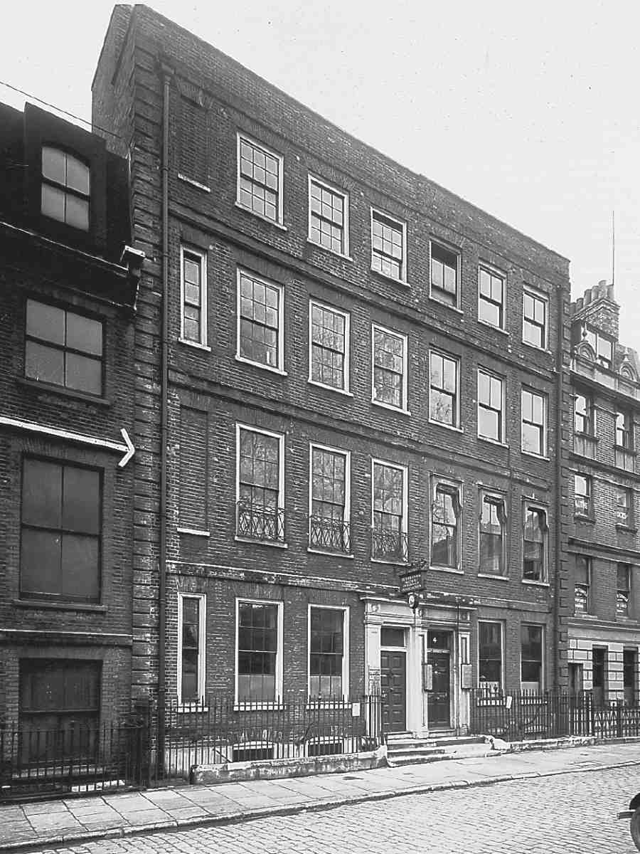
342. Nos 4 and 5 Charterhouse Square in December 1934. Robert Brabourne, lessee, c. 1698
Iron railings and small gates replaced the old fence round the square in 1825. (fn. 46) Apart from on the south side, where they were set back when the roadway here was widened in 1873–4, these railings survived until 1942, when they were removed for salvage. They were replaced during the restoration of the garden in 1949–51 with railings supplied by Bayliss, Jones & Bayliss, of Cannon Street. In this restoration the diagonal path connecting the north-east and south-west corners was not reinstated. (fn. 47) In 1960 the railings were reset on new alignments, when the roadway round the square was enlarged. The present planting arrangement of the square goes back in some measure to 1853 when the old trees were replaced. (fn. 48) Some of the existing plane trees may date from that time.
Charterhouse Square retains three iron gates to the square, at the south ends of the west and east sides and at the neck of Charterhouse Street (formerly Lane). This last gate is the earliest (Ill. 360). Iron gates were installed here in 1791 to replace the gatehouse taken down sixteen years earlier, which stood a little further to the east. They were supplied by Thomas Charles to the designs of Richard Norris, surveyor to the Charterhouse, which bore their cost. (fn. 49) During a fire at premises adjacent at Christmas 1889, the piers and gates were severely damaged by falling masonry. New frames were made for the gates and the piers by John Dodson, incorporating as much of the existing material as possible. (fn. 50) The present gates to Charterhouse Street, therefore, are those of 1791 as reconstructed in 1890. They consist of a central pair for vehicles and separate pedestrian gates on either side.
The gates at the ends of the west and south sides were erected in 1874 at the expense of the City Corporation, in order to close off the parts of the square not affected by the new thoroughfare. They were designed by Sir Horace Jones. (fn. 51) The open piers carry the Sutton arms, and the lamps on the piers are surmounted by Sutton's greyhound crests.
East side
Before 1690 the east side of Charterhouse Yard had the largest houses, with ample gardens stretching eastwards as far as the backs of houses in Aldersgate Street, with which some of them were connected (Ill. 333). The freehold of most of the land here south of Rutland House belonged from the early seventeenth century to the Heneage and Finch families. It had descended from Elizabeth Heneage, daughter of the Elizabethan courtier and plural officeholder, Thomas Heneage; described after the death of her husband, Sir Moyle Finch, as 'the richest widow in England', she was latterly Countess of Winchilsea. (fn. 52) Her son the 2nd Earl of Winchilsea died at his house in Charterhouse Yard in 1639, and the grandson, Heneage Finch, the 3rd Earl, a diplomat, continued to own property here.
From a survey of 1651 the Winchilseas' own house can be identified with the northernmost house, on the site of the present Nos 10–11 Charterhouse Square. Shown as Hshaped on Ogilby & Morgan's map of 1676 (Ill. 333), it was then in the possession of the Marquess of Dorchester, who died there in 1680. To its south is a larger house with a frontage of about 100ft, on the site of the present Nos 6–9, marked 'Lord Grays'. This refers to the Lords Grey of Warke, cousins of the Winchilseas. The first Lord Grey of Warke had owned all or part of the east side since at least 1643–4. (fn. 53) Remnants of fabric associated with him survived inside No. 10 until 1941. Next southwards, where Nos 4 and 5 now stand, was the house occupied by Sir John Bramston in the 1630s. Bramston spent £300 building or rebuilding stables, a coach-house and a tenement, the last being leased to a baker, then sold his property in 1648 to the first Lord Grey. (fn. 54) The nature and early ownership of the houses on the sites of Nos 1–3 at the south end of the east side, shown as vacant by Ogilby & Morgan, are obscure.
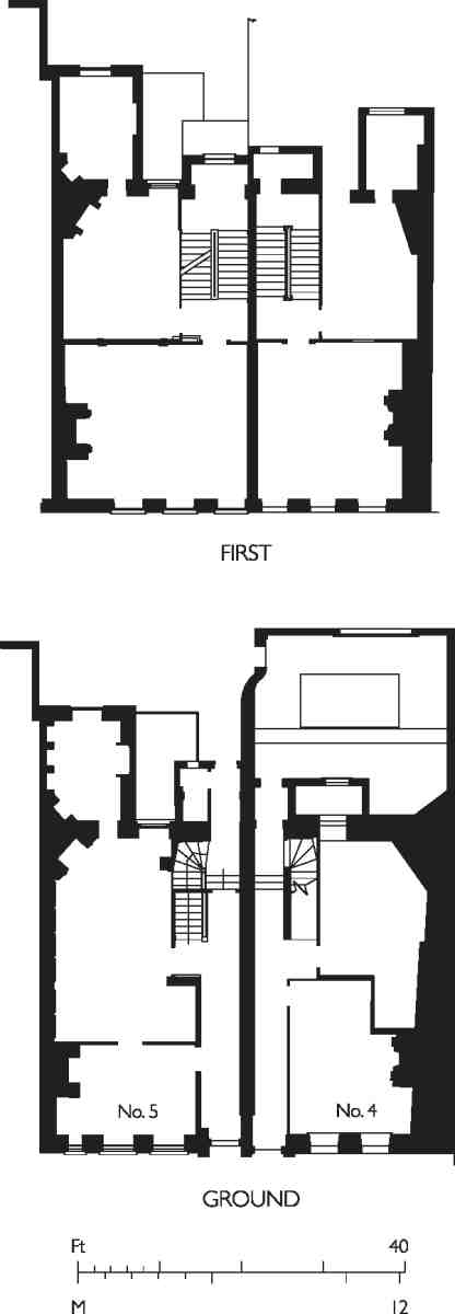
343. Nos 4 and 5 Charterhouse Square, floor plans
Nos 2–5
The plots covered by these addresses and that of the longdemolished No. 1 belong historically to a single development of five houses dating from c. 1691–1700. There is now no No. 1 Charterhouse Square, since its site was taken into the widening of Carthusian Street about 1801. Nos 2 and 3 were rebuilt around that time, but the present state of the fronts is probably due to alterations of c. 1897. Nos 4 and 5 survive from the early development and are among the finest houses in the square (Ill. 340).
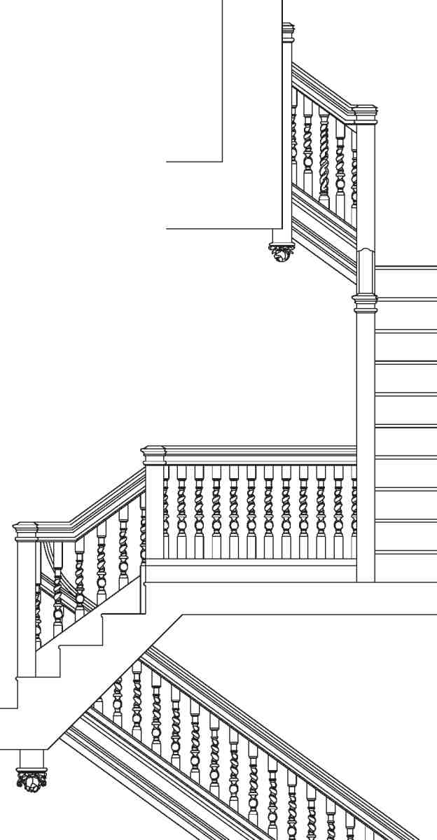
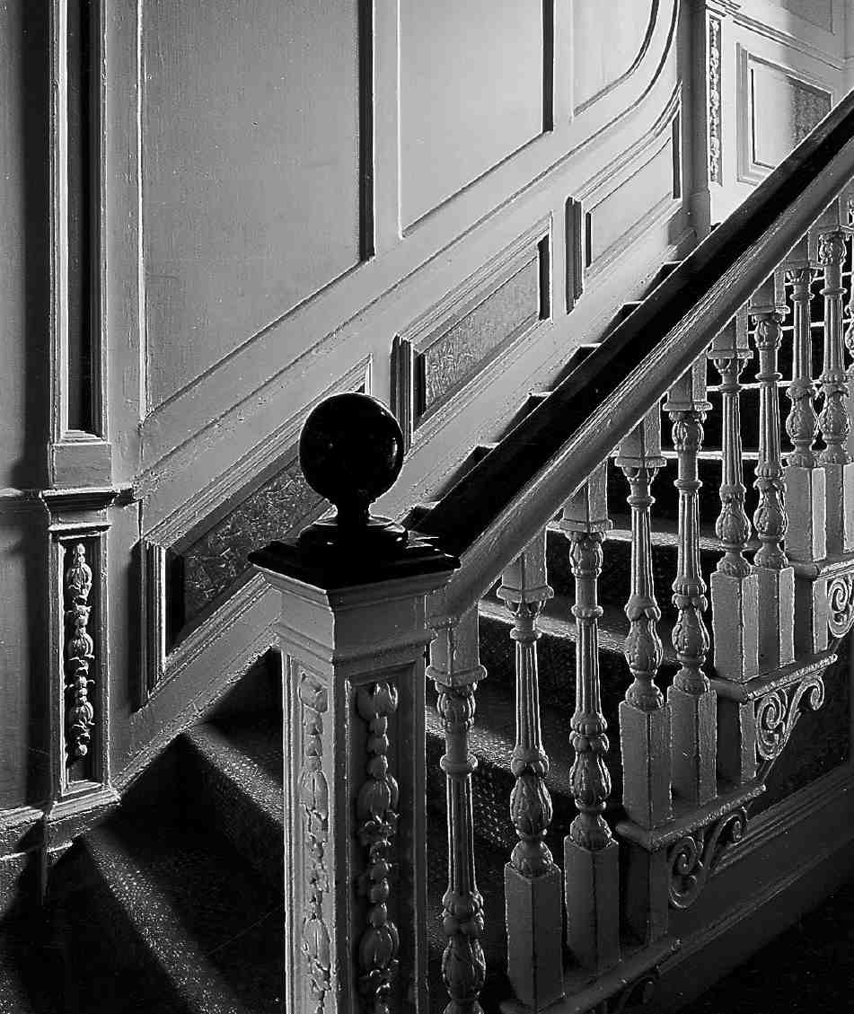
344. No. 4 Charterhouse Square, staircase
By the late seventeenth century all these plots were in the beneficial ownership of the Jemmatt family of Reading, probably on long lease. In 1696 Nathaniel and John Jemmatt and their wives granted to William Desborough, carpenter, a 61-year lease of a house and a walled garden fronting the square and the north side of Carthusian Street (No. 1 Charterhouse Square), and in 1698 two further leases, for 59 years, of plots in the square north of his original holding (Nos 2 and 3). (fn. 55) Two more leases added other ground plots in Carthusian Street. (fn. 56)
Desborough demolished the existing structures and began to erect houses there. His scheme involved widening Carthusian Street by three feet and clearing the buildings towards its east end and in Aldersgate Street. (fn. 57) But financial difficulties soon obliged him to mortgage the incomplete buildings to his suppliers and creditors, and resign his interest in the land to Robert Brabourne, gentleman, of the Inner Temple. (fn. 58) Brabourne, from a family of City merchants, (fn. 59) was a considerable speculator in property. When he died in 1701 he possessed fifteen houses and an inn within the City, as well as the eighteen buildings in the block bounded by Charterhouse Square, Carthusian Street and Aldersgate Street. In 1699 Brabourne added an extra storey to the houses in the square. (fn. 60) As completed, Nos 1–3 were of four full storeys with garrets within a pitched roof (Ill. 335). Nos 1 and 2 were three windows wide and had paired entrances; No. 3 was four windows wide with an entrance left of centre.
345. No. 5 Charterhouse Square, foot of stair in 1999
346. No. 5 Charterhouse Square, first-floor room in March 1943. Panelling and chimneypiece probably of the 1920s reusing old elements
The freehold ownership of the three houses, along with Nos 4–5, passed in 1758–9 to the 2nd Earl of Dartmouth. (fn. 61) The Dartmouths were already related to the Heneages and Finches who had owned much of the east side, but it appears that these properties came to the family only by marriage at this date. They sold No. 1 for the widening of Carthusian Street in 1800, retaining the others along with property facing that street. (fn. 62)
Nos 2 and 3 were then rebuilt. They have undergone successive alterations, but it seems likely that parts of the present fabric date from 1801.
From 1857 to 1879, No. 2 was occupied by William Snoxell, a collector of clocks, automata, and memorabilia connected with artists, literary figures and composers. His collection encompassed such items as: 'Two Ottoman Square Foot Stools, covered with red cloth and fringed, on pressure with the foot, produces a shrieking noise … The Mechanical Performing Crab … A Cat sitting under a chair, the seat of which, on being slightly pressed, produces the shriek of that animal when in great torture'. He also claimed to possess Handel's watch, original will and an inventory of his household goods of 1759, as well as a portrait of the composer by 'Woolfand'—probably Wolfgang—and the 'original Anvil and Hammer of the "Harmonious Blacksmith"'. Amongst his literary papers are listed Evelyn's diary and architectural drawings. After Snoxell's death in 1879 his collection was sold, a number of items later passing to the British Museum. (fn. 63)
In 1878 Frederick Patterson acquired No. 3, which had been in use as a lodging-house since the mid-1850s. (fn. 64) After Snoxell died, Patterson took over his lease and the two properties became known as 'Patterson's Hotel'. They were only jointly rated from 1898, when Robert Henry Barnes, licensed victualler, acquired a 60-year lease from the Earl of Dartmouth. (fn. 65) Barnes was already the occupier in the previous year, when he employed Edwards & Co. to make alterations. (fn. 66) The faintly Jacobean ornament extant on the Carthusian Street frontage and formerly applied also on the front facing the square may date from this time. It has the flavour of pub architecture. In the next decade the premises were occupied by J. A. Berthes, following whose bankruptcy there was a proposal, probably carried out, to divide it into three shops. (fn. 67)
Nos 4 and 5 are now the only survivors of the William and Mary rebuilding of Charterhouse Square (Ills 342, 343). They were built on part of the land leased in 1696 by the Jemmatts to William Desborough. Presumably because of his financial problems, the sites were still vacant in October 1697. (fn. 68) The two houses appear to have been built by Robert Brabourne between then and his death in September 1701. Thomas Dorrington of St Andrew Holborn, bricklayer, was probably the main contractor. (fn. 69) No. 5 was fitted out for Brabourne's own occupation, and the ground-floor front room originally had his arms carved over the chimneypiece, while panelling there and elsewhere in the house bore his initials. (fn. 70)
With their higher storeys, Nos 4 and 5 were more ambitious than Nos 1–3 and perhaps the tallest houses in the square. They shared a flat leaded roof, shown in early views adorned with a central cupola or belvedere and a balustrade—unusually pretentious features for terrace houses (Ill. 335). The front elevations are consistent in design with a date of about 1700, but the existing brickwork, particularly the yellow London stocks, suggests that they have been much rebuilt or refaced. The heightening of the paired doorcases to allow fanlights probably took place in the early nineteenth century.
No. 5 is half a bay wider than No. 4, but otherwise the plans of the two houses were originally almost mirror images, with the classic two-room layout per floor and rear closet wings rising to all four storeys. The closet wing to No. 4 is set at an angle, reflecting the boundary with No. 3. The panelled staircases are the best features in the two houses; they are similar, although that at No. 5 is grander (Ills 344, 345). Both are of dog-leg type with a narrow stairwell. That at No. 4 has twisted balusters and ballflower drop-finials to the newel posts. The lower flights of the staircase at No. 5 have carved tread-ends, delicately carved paired balusters, and square newel posts with foliage and flower panels. Vestiges of the original panelling remain in the first-floor front room at No. 4, along with a good marble chimneypiece.
While some rooms at No. 5 also have remnants of panelling, Brabourne's panelling and carving in the groundfloor front room was sold in 1919. Together with a carved archway, its supporting pillars in the hall, and a lead cistern in the yard, it was bought by the Hon. Clive Pearson. (fn. 71) He probably installed the woodwork in his London house at No. 32 Grosvenor Square, demolished in 1957, (fn. 72) while the cistern may have gone eventually to his country house, at Parham, Sussex. The present Jacobethan wooden chimneypieces and linenfold panelling in the front rooms of the principal floors at No. 5 (Ill. 346) were presumably installed after this removal.
Both houses were well occupied until the later Victorian period. Between 1812 and 1869, No. 4 was home to doctors. John Richard Farre, founder member of and eminent physician to the Royal London Ophthalmic Hospital at No. 40, was succeeded in 1847 by John Mann, surgeon, who used the back room on the ground floor as his consulting-room and the rear closet as his surgery, but the rest of the house as his family home. (fn. 73) From 1870 to 1892 it was used as a staff hostel by Ward, Sturt & Sharp, warehousemen, wholesale hosiers, haberdashers and flannelmen in the City, with a factory at Belper, Derbyshire. In 1881 twelve warehousemen, mostly in their twenties, were accommodated there, looked after by a married couple. By 1908 No. 4 had become offices, and it has been used for this purpose ever since. (fn. 74) The freehold remained in the hands of the family of the Earl of Dartmouth until at least 1913. (fn. 75)
347. No. 10 Charterhouse Square, view before 1935, with No. 9 to right and No. 11 to left. All demolished
348. No. 10 Charterhouse Square, detail of staircase in 1846, drawing by John Wykeham Archer
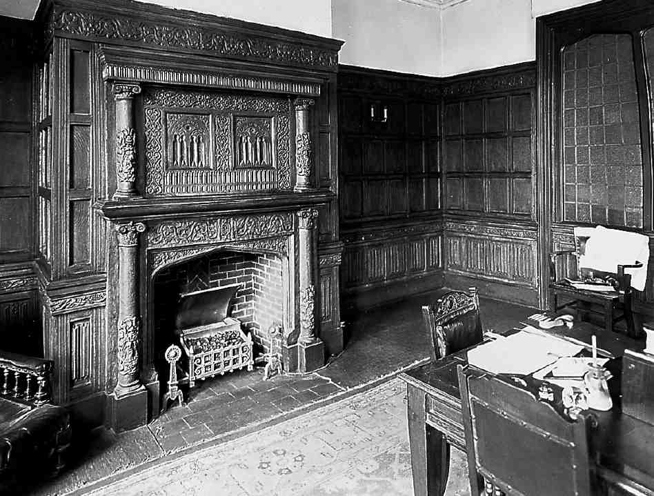
349. No. 10 Charterhouse Square, fireplace on ground floor, drawn in October 1942. The cupboards to the left are in the place of a demolished staircase
No. 5 enjoyed Georgian residents of good standing. In 1845 it became the parsonage for St Sepulchre, Holborn. Though just outside the parish, it was considered the most eligible property then available, especially 'as there are so very few private houses of a suitable description within or near the Parish'. (fn. 76) The freehold was purchased from the Earl of Dartmouth for about £16,000. It continued as the parsonage until 1929, by which time it had become too large and expensive to maintain on the stipend. On the death of the incumbent in that year, the freehold was offered to the Ecclesiastical Commissioners but they declined it. (fn. 77) Since 1931–2 No. 5 has been used as offices.
350. No. 11 Charterhouse Square, plans and front elevation in 1845. Demolished
Nos 6–11
Nos 6–9 Charterhouse Square now consists of a suave block of flats dating from 1935–7, while Nos 10–11 is an office block of 1957–9. Their immediate predecessors were houses of the 1690s.
The extensive mansion houses on these sites are marked on Ogilby & Morgan's map as belonging to Lord Grey of Warke and the Marquess of Dorchester (Ill. 333). No later than 1694 they had been acquired by Peter Ward of St Botolph without Aldersgate, brewer, who had demolished most of the group and erected six houses on the site. (fn. 78) The sites remained separate, with the four houses on Lord Grey's site (Nos 6–9) shown in early views as of three full storeys with a high roof, while the more northerly houses (Nos 10 and 11) are represented as wider but with only two full storeys (Ills 334, 335). Nos 6–9 were not well recorded before their demolition about 1935. Photographs of the fronts of Nos 10 and 11 not many years before their destruction by bombing on 10 May 1941 show that No. 10 remained only two storeys high but had been harshly refronted (Ill. 347). No. 11 had its original plain brick front with lighter dressings round the windows; it had been heightened by a storey in the original style. The houses had acquired different styles of Georgian door hoods with broken pediments and fanlights. Inside No. 11 there were four principal rooms on each floor. The staircase was squeezed between the front and back rooms on the north side (Ill. 350).
Perhaps at No. 11, more certainly at No. 10, Ward retained elements of the previous houses on these sites. These were brought to light by the inter-war owner of No. 10, Frank Daphne, a solicitor, who called it 'The Dower House' and claimed it as 'the house from which Henry VIII married Catherine Parr'. A description of the interior of No. 10 in 1933 mentions a vaulted brick basement (perhaps surviving from Lord Latimer's house here), panelled reception rooms, and a large dining-room at the front which contained the Grey coat of arms carved in stone, and the family motto De bon vouloir servir le Roy. (fn. 79) A drawing of a stair in Charterhouse Square made in 1846 seems to tally with this description and probably refers to No. 10 (Ill. 348). (fn. 80) It shows a balustrade in midseventeenth century style incorporating flowing acanthus leaves, coronet and portcullis and the same coat of arms. In 1938–9 during further renovations in the basement Daphne uncovered 'a great deal of Tudor work including a large fireplace, some 18ft. in width, similar to the fire places in the great kitchen at Hampton Court; and also some squint brick work which rather puzzles me as to its origin and use'. This fireplace survived the Blitz and was drawn in 1942 (Ill. 349). But despite efforts to incorporate it in the new building on the site, it was allowed to deteriorate and was eventually destroyed. (fn. 81)
All six houses here continued as private dwellings until at least the 1830s, after which a mixture of occupants became the norm. A ladies' school was at No. 10 from 1843, moving to No. 6 in 1859. The latter house was acquired soon afterwards by Copestake, Crampton & Co. Ltd, Cheapside lace manufacturers and warehousemen, who by 1872 had expanded to the whole of Nos 6–10, using the buildings as a staff hostel. In 1881 they housed at least 100 male and 18 female employees. (fn. 82) The vicarage of St Botolph without Aldersgate was at No. 7 by 1839, but transferred in 1845 to No. 11, where it long remained, while No. 7 became the temporary vicarage of St Thomas's, Charterhouse. Also at No. 11 in the early 1870s was the City Young Women's Association, a forerunner of the Young Women's Christian Association.
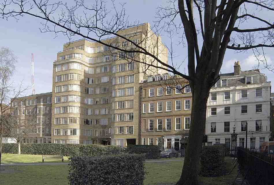
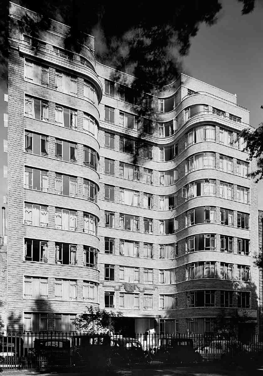
Nos 6–9, now called Florin Court, is the most prominent building on the east side of the square (Ills 340, 351–354). A ten-storey block of flats in the streamlined moderne style, it was built in 1935–7 for Charterhouse Ltd (by 1937 Charter Estates). The architects were Guy Morgan & Partners, specialists at that time in such flats. The builders were J. Gerrard & Sons Ltd, and the cost about £74,000. The interior decoration was by Mrs V. M. Thomas.
The U-plan of the building was adopted to give an outlook over the square to the maximum number of rooms. The London County Council gave permission for the recessed centre of the main front to be carried up to the full height of the block without the usual set-back, but insisted that the two projecting wings should have the uppermost storey set back. This allowed the top flats to have small roof gardens.
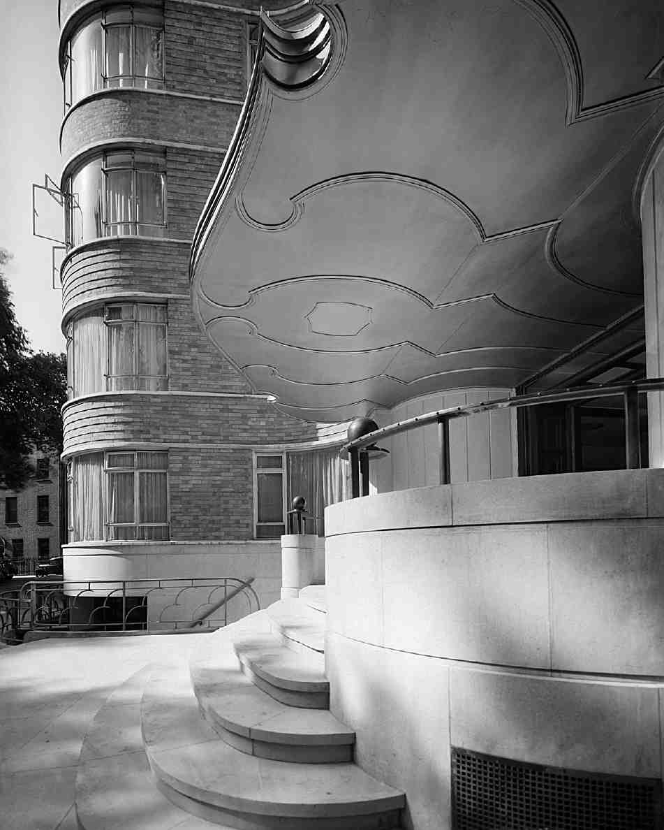
The block is steel-framed and clad in pale yellow and brown mottled bricks of 'a particularly high quality' produced by Williamson Cliff Ltd of Great Casterton, near Stamford, who also made the special bricks for the arms of Charterhouse over the entrance. The flowing cantilevered entrance canopy is covered in copper and sheet steel. The entrance hall had a marble floor inset with the arms of Charterhouse, but this area is now carpeted.
351. Nos 6–9 Charterhouse Square, plan of typical upper floor as built
The internal planning was dictated by the expectation that businessmen, needing to be at Smithfield Market early in the morning, would find the flats convenient piedsà-terre. Many of the flats were no more than bedsitters, in some cases with a bed recess, allowing the total number of flats to come to 126. Only one flat per floor had two bedrooms and a sitting-room. The ground floor included a porter's office and flat for the head porter. In the basement was a public restaurant, a cocktail bar and a clubroom, and beneath was a garage with parking for twenty cars. Behind the block a single-storey building contained two squash courts. (fn. 83) By the early 1950s some of the flats were in use as offices. (fn. 84)
In 1988 the block was refurbished and modernized for Regalian Properties at a cost of about £2 million, by architects Hildebrand & Glicker (job architect Stephen Bodimeade; interior designer Andrew Dandridge), and once again became fully residential. It then acquired the name Florin Court. The roof gardens were reinstated, and up-to-date features such as jacuzzis and a basement swimming-pool were installed. In its restored state Florin Court appeared on television in the late 1980s and 90s in the guise of Whitehaven Mansions, the home of Agatha Christie's fictional detective, Hercule Poirot. (fn. 85)
352–354. Nos 6–9 Charterhouse Square in 1937. Guy Morgan & Partners, architects, 1935–7. Main front, entrance canopy and entrance hall
Nos 10–11 is an office block, built in 1957–9 to replace the two houses here destroyed in the Blitz (Ill. 340). It was designed by H. C. Wilkerson & Partners. (fn. 86) Above a basement, it has five storeys at the front and six at the rear. Of purplish-grey brick, it is minimally neo-Georgian; the front elevation includes two three-storey canted bays, with the entrance set at the southern end. The first occupants were a subsidiary of the De Havilland aeronautical engineering group, who gave the building the name Welkin House, dropped after the company's departure in the early 1970s. (fn. 87)
North side
Occupying the north side of the square between the Charterhouse and Rutland Place is a small group of houses, Nos 12, 12a and 13–14. Though they all look like early nineteenth-century buildings (Ill. 355), Nos 13–14, formerly two houses but now thrown together, belong in part to the late seventeenth century. They once ranged continuous to the west with a wing of the Charterhouse, and to the east with a short run of houses which touched the corner of No. 11 on the east side. The roadway of Rutland Place to their east is a creation of the 1820s.
The origin of this group is bound up with the history of Rutland House, to be covered in the monograph on the Charterhouse. The south-western corner of that mansion, including a narrow entrance into its main courtyard, occupied the sites of Nos 12 and 12a (Ills 333, 336, 337). The break-up of the Rutland House property followed upon its return to the ownership of the 2nd Duke of Buckingham in 1660 after the Restoration. In 1662 Buckingham granted the main house to John Eaton, mercer, who invited James Nelthorpe, a resident of Charterhouse Yard, to purchase a half share. (fn. 88) In 1688 the latter's brother, Sir Goddard Nelthorpe, leased the portion west of the entrance and courtyard to Francis Stacey, citizen and clothworker, for 52 years. Stacey was required to pull down the existing buildings and build two new 'good and substantial' brick houses of the second rate, to be completed by that Christmas. (fn. 89) A former gallery behind was to be rebuilt and incorporated into the eastern house. The outcome was an unequal pair of houses, No. 14 threeand-a-half windows wide, No. 13 six-and-a-half windows wide; the eastern half of No. 13 covered the site of the present No. 12.
By the 1780s No. 13 was a boarding-house for Charterhouse schoolboys, but No. 14 remained a private residence. (fn. 90) Here Samuel Sharwood, a leather cutter, acquired the freehold and seems to have made substantial alterations about 1810–11. (fn. 91) These entailed adding a storey, refacing the building with yellow stock bricks and remodelling the first floor with French windows and a balcony with cast-iron railings, formerly supplemented by a trellis and awning. Much of the rendering on this storey, however, is due to alterations by the Charterhouse's architects Seely & Paget in the mid-1960s. (fn. 92)
355. Nos 12–14 Charterhouse Square (right to left) in 1997
Between 1810 and 1825 the headmaster of Charterhouse School, the Rev. John Russell, acquired all the sites in this corner of the square and gave it the present configuration. He bought No. 14 from Sharwood for £2,500 in 1818, turning it into another boarding-house like No. 13. (fn. 93) Next he bought the adjacent properties to the east, acquiring a lease from the Charterhouse of an old gabled house that had been the entrance to Rutland House, and part of the freehold estate of Sir Robert Harry Inglis beyond. This enabled him to abolish Rutland Court, the open space north of the Rutland House entrance, and lay out the line of Rutland Place further east. (fn. 94) On the east side of this new cul-de-sac he built two three-storey houses in 1826–7, Nos 1 and 2 Rutland Place (on the site now occupied by the former headmaster's house of Merchant Taylors' School). (fn. 95) On the south-west corner in 1832 Russell erected a third house, No. 3 Rutland Place, now No. 12A Charterhouse Square. (fn. 96) Originally the front elevation had no bow window, but a pair of flush windows to the ground and first floors. (fn. 97)
Following Russell's resignation as schoolmaster, his properties were bought in September 1833 by John Cross, a watch manufacturer at No. 41 Charterhouse Square, who undertook alterations. These involved dividing No. 13 into two, and rebuilding the fronts to the square so as to create the present No. 12. The unbalanced frontages of Nos 12 and 13 echo the original six-and-a-half bay façade. (fn. 98)
356. No. 13 Charterhouse Square, plan and panelling of first-floor front room
For some years the four houses reverted to private residences. Nos 13 and 14 were occupied in the 1850s and 60s by surgeons of distinction connected with St Bartholomew's Hospital—respectively, William Scovell Savory (later baronet), President of the Royal College of Surgeons and surgeon-extraordinary to Queen Victoria, and his colleague Frederic Carpenter Skey. But from around 1870 Nos 12, 13 and 14 all became boarding-houses, soon euphemistically called hotels. One was Kershaw's Hotel, initially at No. 14, extended in 1884 to No. 12 to add to two further houses James Kershaw had in the square. This commercial hotel, successfully continued by his daughter Alice Gurner, was the only one in the square deemed worthy of mention in the 1879 edition of Baedeker's London guide. (fn. 99) By 1905 under new management renamed the Brunswick Hotel, it covered Nos 12, 13 and 14. (fn. 100) The last name for a hotel at these addresses was the Fife Hotel (c. 1912–38). Since then these houses have largely been used as offices.
Between 1887 and 1903 No. 12a acted as a boardinghouse for Merchant Taylors' School, which took over the Charterhouse school site in 1872. (fn. 101) It was then occupied by the developer Mark Bromet, one-time rag and general merchant at the Charterhouse Works, Northburgh Street, who added the present three-tier bow window at the front in 1904–5. (fn. 102) The house served as the rectory of St Bartholomew-the-Great from about 1907 to 1913.
The interiors of the four houses reflect their chequered history. At No. 14 there are remains of the seventeenth-century stair-rail. Otherwise the dog-leg staircase has typical early nineteenth-century balusters. The staircases at Nos 12a, 12 and 13 are also of early nineteenth-century type, but No. 12a also has a short extra stair-rail on the first-floor landing, with four twisted balusters of c. 1700, perhaps from another house. Remarkably, the front firstfloor room at No. 13 retains its late seventeenth-century form, complete with bolection-moulded panelling and a blocked doorway formerly connecting with the eastern half of the house (Ill. 356).
North-west side and Charterhouse Mews
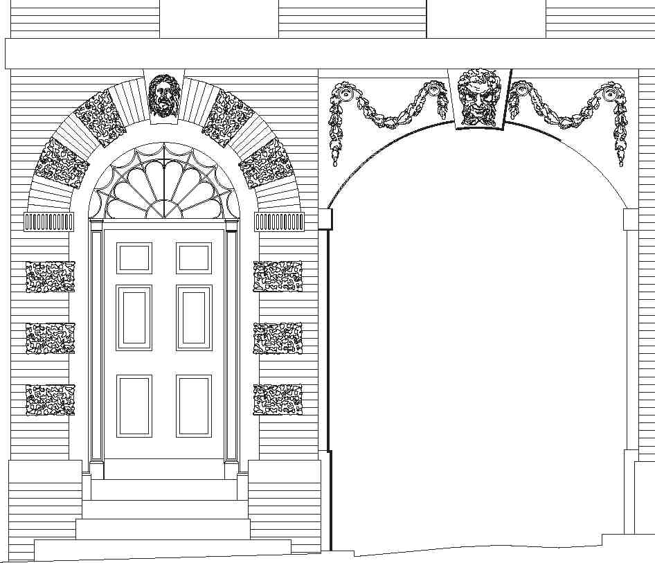
This is the side of Charterhouse Square most intimately linked with the Charterhouse, which owned most of the freeholds. To the west of No. 14 there is now a gap, filled until the Second World War by buildings of the Charterhouse fronting Chapel Court. Where a corner of this court comes close to the square (Ill. 357), the roadway angles southwards and an ancient high chequerboard wall of flint and Reigate stone begins. It dates from 1405 or soon afterwards, and runs westwards to the gate of the Charterhouse. Originally it continued further west beyond the gate. The medieval fabric of the gate, of the same date, is now confined to a single storey with a four-centred archway. It is surmounted and flanked to its west by a fine early Georgian house originally known as the Physician's House, now numbered 17 in the square. Beyond this, the granary yard of the priory once occupied land west of the gate. Today these fronts are filled by a large block of 1899–1902, purpose-built as a hotel (Ill. 360). Then, opposite the gates to Charterhouse Street, is the entrance to Charterhouse Mews, developed from stabling and coach-houses for Charterhouse officers. No. 17 is briefly described below: a fuller account of the house and gateway will appear in the Charterhouse monograph.
No. 17
This house was built in 1716 for the physician to the Charterhouse, Henry Levett, replacing the old house over the gateway which had been occupied by his predecessor since the 1690s (Ills 335–337). The design was provided by Levett, and half the estimated cost of £800 was paid by the Charterhouse governors. (fn. 103) The date 1716, together with the initials S[utton's] H[ospital], is carried on the rainwater heads. The names of the craftsmen are not known, but they are likely to have been the same as those who built the now-demolished adjoining houses, Nos 18 and 19, directly afterwards.
No. 17 is a handsome building fronted in plum brick with red-brick dressings (Ill. 358). The western half is of three full storeys above ground, while the rest is built over the gate. The fine hooded timber doorcase is adorned with fluted Corinthian pilasters and a segmental pediment. The fanlight was inserted in 1831. Inside, a panelled passageway leads to a staircase which has fluted newel posts, threeto-a-tread barleysugar balusters, carved tread-ends and a panelled dado. The plaster cornices in the principal rooms may also be original. There are good fireplaces; one of them, in marble with mantel and jambs, was installed by George Burnill in 1753. (fn. 104) Since the 1950s No. 17 has been the Master's Lodge for the Charterhouse.
The flat hood above the Charterhouse gate, supported by brackets in the form of stylized lions, was added during the late eighteenth century.
Nos 18–21 (demolished) and 22
357. Charterhouse Square, north-west side, c. 1816. No. 17 to left
The first development of these sites took place from 1718, when Edward Wastfield or Westfield, citizen and grocer of London, took a lease from the Charterhouse of the site next to the newly built No. 17, agreeing to spend at least £1,200 on the erection of two new houses of the second rate. (fn. 105) These, the former Nos 18 and 19, were four storeys high and four windows wide. Their entrance hoods and doors were like that at No. 17, to judge from an early view of the square (Ill. 337). Inside, the houses had two rooms per floor and closet wings back to back. Beyond the end wall of No. 19 was the old entrance to the stable yard (now Charterhouse Mews), and then three tenements also leased to Wastfield, facing Cowface Court. (fn. 106)
358. No. 17 Charterhouse Square and entrance to the Charterhouse in 1998. The former Physician's House, built in 1716 partly over the medieval gateway. Now the Master's Lodge
Beyond Nos 18 and 19 a gap existed until the 1780s. Following a plan carried through in 1775 to widen Charterhouse Lane, demolish the old gateway to the lane and replace it with iron gates, the governors of the Charterhouse asked their surveyor, Charles Evans, to produce a scheme to remove Cowface Court, shift the stable entrance further west and build new houses along the frontage west of No. 19. (fn. 107) Several variants were proposed. In the version finally built under an agreement with John Wilkinson Long, carpenter, in 1786–7, three houses of four full storeys were erected (numbered in the square), followed by two of three storeys beyond (in Charterhouse Lane). Of the houses in the square, Nos 20 and 21 were wider than the other, No. 22, over the new entrance into the mews. (fn. 108)
359. No. 22 Charterhouse Square, elevation of front door, and arch to Charterhouse Mews
No. 22, next to the iron gates, is the only survivor. It is of yellow brick, with Coade-stone dressings. The doorway has vermiculated rustication and a keystone mask, and the archway also has a mask and swags (Ills 359, 360). An elliptical stairwell rises from the broad hallway. The ceiling of the front room on the first floor has five painted roundels depicting the arts. These are probably by Thomas Stowers, the first occupant of the house. Both he and his son, also Thomas, were landscape and topographical painters, as well as running a painting and decorating business which carried out work for the Charterhouse. A workshop and loft at the rear were used by Stowers for storing his utensils and stock. (fn. 109)
360. Nos 18–21 and 22 Charterhouse Square, and gates, in 2007
From 1882 No. 22 was occupied by William Hooper Matthews, who ran a firm manufacturing letter-binders. In 1884 he took a new lease conditional on his spending at least £400 erecting a building at the rear. This is a twostorey brick structure, with broad windows on both floors. No. 22 is now a migraine clinic, while the workshop to the rear is a restaurant.
Nos 18–21, Malmaison London hotel
In 1856 the lessee of No. 19 was Elizabeth Cocker. Gradually this and its neighbours, Nos 20 and 21, turned into a private hotel known as Cocker's Hotel. (fn. 110) It expanded in the 1880s and 90s, taking in No. 18 and extending behind. (fn. 111)
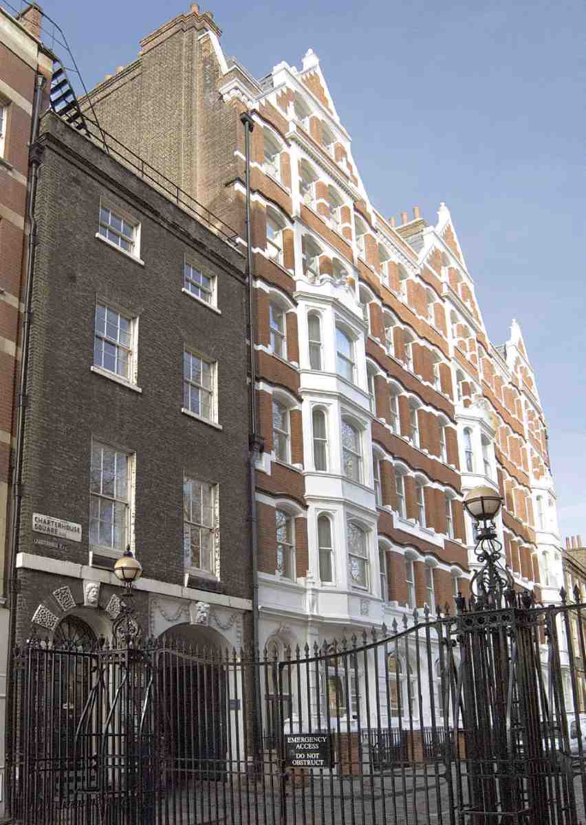
In 1899 the Charterhouse granted a new lease to the local developer Mark Bromet, on condition that he would replace the four houses with a new building costing at least £20,000, to the designs of its estate surveyor, E. B. I'Anson. At some point the project was taken over by the developer-builders Arthur Mazzini Wheeler and William Warren of Bryanston Square and their architect, Edward Haslehurst, to whom the existing front may cautiously be attributed (Ill. 360). Under the proprietorship of Wheeler and Warren it opened in 1902 as the Charterhouse Hotel, with 107 bedrooms. (fn. 112) A large, symmetrical but coarse building, of seven storeys over a semi-basement, it dwarfs No. 17 to its east. It is finished in red bricks with stone dressings, now white-painted. The hotel was popular before the First World War among provincial businessmen. Appropriated as a military hospital in 1918, it did not reopen as a hotel after the war. From 1923 the building was known as Charterhouse Chambers and occupied by small businesses plus a restaurant. It was bought by St Bartholomew's Hospital in 1927 and afterwards long used in whole or part for nurses' accommodation. (fn. 113) Sold in 1997 and entirely reconstructed behind the fronts in 2002–4 by RHWL Architects (Renton Howard Wood Levin Partnership), working with the builders Try Construction, it has returned to hotel use as the Malmaison London. (fn. 114) A bust of Napoleon presides from the back of the open-plan lobby.
Charterhouse Mews
Part of the rebuilding by John Wilkinson Long in 1786–7 involved erecting coach-houses and stables in Charterhouse Mews, long since demolished. (fn. 115) Fresh coach-houses, stables and workshops were built here in 1884 (Ill. 361). (fn. 116) The present Nos 1–4, in the shadow of the high back of the Malmaison hotel, consist of low-key offices erected about 1988 by the developers Homesteads Ltd, with their in-house designers Kinson Architects and Clive Elvin as project architect. (fn. 117) The buildings are in a pastiche-Georgian brick style, with a smattering of shaped gables and pedimented windows.
361. Charterhouse Mews, elevation of stables. George Perry, architect, 1884. Demolished
362. Nos 23–28 Charterhouse Square, front elevation of warehouses built for Edwin King, 1885–6. Demolished
West side
Historically, the west side of the square was the least eligible or coherent, and the least-often illustrated. There have been three main phases of redevelopment, in 1700, 1885–6, and 1956–62. The present building known as Nos 23–28 Charterhouse Square occupies the whole of this block, bounded north and south by branches of Charterhouse Street and on the west by Fox and Knot Street.
In the late sixteenth century much of the frontage on the west side of the yard was held by John Sinclair, clerk of works at the Charterhouse. His plot contained a bowling alley and dicing houses. (fn. 118) A survey of 1651 shows three main features here: an 'old house or shed' at the northern end, set back from the frontage and abutting the gate in Charterhouse Lane; then a big area of ground with much open space behind held by Allen Law, probably in succession to Sinclair; and a row of small houses running westwards at the south end and described as 'Mr Laws new tenements'. (fn. 119) By 1676 the shed at the north end had been replaced by a row of houses running along Charterhouse Lane, of which the easternmost one abutting the gate was a pub in the mid-eighteenth century. Part of this building disappeared when Charterhouse Lane was widened and the old gateway demolished in 1775. A porter's lodge for the new iron gate was subsequently built by Thomas Draper, bricklayer, and designated No. 23 Charterhouse Square. (fn. 120)
In 1700 the Charterhouse advertised the rest of the ground along the western frontage, evidently their freehold land, as available for building. An agreement followed with Thomas Fletcher and William Sharpe, bricklayers, to spend at least £2,000 on replacing the old buildings with nine new brick houses, Nos 24–32, by Midsummer 1702. The houses had three full storeys with 'good and convenient Garretts'. (fn. 121) At the south end the last house returned briefly eastwards to connect with the line of Hayne (then Charterhouse) Street (Ill. 334).
Two of these houses, Nos 30 and 31, were burnt down in 1836 and rebuilt slightly forward of the previous building line. (fn. 122) The replacements did not last long, for Nos 29–32 disappeared in the clearances of 1864–74 for the Metropolitan Railway and Charterhouse Street. The leases of the remaining Nos 24–28 expired in 1885, when the Charterhouse decided to rebuild the whole west side of the square as commercial premises. An agreement was made with the developer Edwin King of Fenchurch Avenue for a five-storey warehouse, erected in 1885–6 and probably designed by another member of the King family, Mark William King, surveyor, of the same address. (fn. 123) Typically for its date and genre, the building had narrow piers and broad windows, round-headed on the top storey, the centre of the front being emphasized and given an ornamental pediment (Ill. 362). It was very similar to warehouses erected by the Kings in Clerkenwell Road in 1888–90 (see pages 403–4). The internal construction was probably largely of iron.
363. Nos 23–28 Charterhouse Square, looking north-west in 2000
The first occupants of this block (Nos 23–28) were printers and manufacturing stationers. The northern part, Nos 23–25, gave some trouble. A fire in 1889 caused some of the fabric to collapse. (fn. 124) The buildings were reinstated, but the noise of the printing machinery annoyed the square's inhabitants, who felt their 'health, comfort and rest' as well as their financial interests affected. (fn. 125) By 1895 this end had been taken over by a firm of blouse manufacturers. (fn. 126) No. 27 was first occupied by Sebastian Ziani de Ferranti, the distinguished electrical engineer, inventor and manufacturer, who was just embarking on the construction and equipping of Deptford Power Station. It was here that in 1890 the firm of S. Z. de Ferranti Ltd was formed. Ferranti gave up No. 27 when he opened a new factory in 1896 near Oldham. (fn. 127) By the mid-1930s most of the building was occupied by clothing firms of various descriptions, including the hat manufacturer J. Collett Ltd.
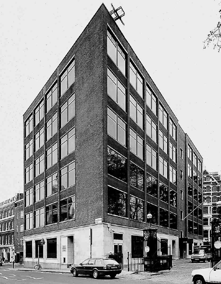
The south end of the block, Nos 26–28, was destroyed in the 1941 air-raids. Its replacement, a factory and offices for Colletts designed by Lewis Solomon, Son & Joseph, architects, was built in 1954–6 at an approximate cost of £135,000 and became the first section of the current Nos 23–28. (fn. 128) Of six storeys, one more than its predecessor, it is a massive but dignified building, with artificial stone cladding on the ground storey, brick above, and ample windows, all on a reinforced-concrete frame (Ill. 363). The new block was evidently designed with the thought of an extension to the north, where Nos 23–25 of the 1885–6 building still remained. In 1962 this extension was added on behalf of Colletts by Lewis Solomon, Kaye & Partners. (fn. 129) Colletts at that time were said to be the largest ladies' hat manufacturer in Europe, yet in about 1974 they went into voluntary liquidation. (fn. 130) Subsequently Nos 23–28 were converted for use as banking offices, with changes to the windows. (fn. 131)
South side
The plots on the south side of the square today are shallow, particularly at the west end, because of the alignment of the railway cutting directly behind, occupied by Barbican Station. The existing buildings, Nos 33–43, are all of the warehouse type. They date from 1876–7, following the construction of the railway and the projection of the new through roadway along the south side.
In the seventeenth century there were three main holdings on this side of Charterhouse Yard. At the west end a broad double plot was occupied by a large building with a garden on its west side fronting the square, and a coachhouse and stables. This was the house which had been the Venetian ambassador's residence. In 1651 it belonged to Lord Dunsmore (also known as the 1st Earl of Chichester). In the 1680s, when it was in the hands of Sir Nicholas Crispe, 2nd Bart, it was described as old. (fn. 132) In the centre of the south side a group of houses was the property of Stephen Anderson in 1651. (fn. 133) They are shown on Ogilby & Morgan's map of 1676 as a row of five, with one set back from the others (Ill. 333). Beyond them to the east stood one of the largest houses in Charterhouse Yard and the only one within the boundaries of the City. It was occupied in 1651 by the Countess of Nottingham and is shown by Ogilby & Morgan as enjoying a broad frontage and a square, formally laid-out garden behind.
Redevelopment here began with the demolition of the Dunsmore property at the west end and the laying out in 1687 of what is now Hayne Street by Thomas Neale, no doubt the developer of that name best known for his work around Seven Dials. Originally known as Charterhouse Street, this cut through the western part of the site from Long Lane, culminating in two large corner houses 'of the second rate' (Ill. 334). (fn. 134) The first of the developments of this period around Charterhouse Yard, it was described in 1720 as 'a neat new built Place … with very neat and genteel Houses, well inhabited'. (fn. 135) The proprietor of the new street, whose relation to Neale is not known, was Henry Plumptre or Plumtree. (fn. 136) To the east of the new street, Plumptre had erected a pair of houses by 1691, Nos 33 and 34 Charterhouse Square. (fn. 137) Five and three windows wide respectively, they both had three storeys with attics. The centre of the south side was rebuilt in 1703–5 following an agreement between the freeholder, Sir Rowland Winn of Nostell Priory, Yorkshire, with Richard Boulton and George Willson, carpenters, for the erection of six new houses, Nos 35–40. (fn. 138) Each was of three bays and three storeys, with garrets and cellars. The four central houses consisted of two handed pairs, while the outer ones had mirrored plans (Ill. 364). There were broken swan-necked pediments above the doors, spanning both entrances in the central pairs.
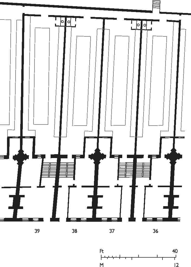
364. Nos 36–39 Charterhouse Square, plans of four of a row of six houses (Nos 35–40) of 1703–5. Demolished
Beyond these houses, the former Countess of Nottingham's house was replaced at about the same date by a grand house, No. 41, set behind a forecourt fronted by railings on a dwarf wall between high gate piers (Ill. 334). This house was seven windows wide with a central pedimented doorway and had two full storeys plus dormers, over a semi-basement. The front included a modillioned eaves cornice and quoining. There were six rooms on each of the principal floors. (fn. 139) The original builder of this house is not known, but it may have been erected for the Wollaston family. Four generations of Wollastons, intellectual clergymen, lived in houses in the square. The first was William Wollaston, author of The Religion of Nature Delineated, who moved here on his marriage to a London merchant heiress in 1689, continuing until he died in 1724. It was said of him that 'for above thirty years before his death, he had not been absent from his habitation in Charterhouse-square so much as one whole night'. (fn. 140) No. 41 may therefore have been built for William Wollaston around 1694, but the record is confused by his son Francis Wollaston (1694–1774), who stated that his father lived at different addresses in the square. Between at least 1743 and 1790 Francis Wollaston and his better-known son, the astronomer Francis Wollaston (1731–1815), lived at No. 41, but another house on the south side, No. 37, was also associated with the family. Francis junior's son, Francis John Wollaston (1762–1823), lecturer in chemistry, was born in the square. (fn. 141)
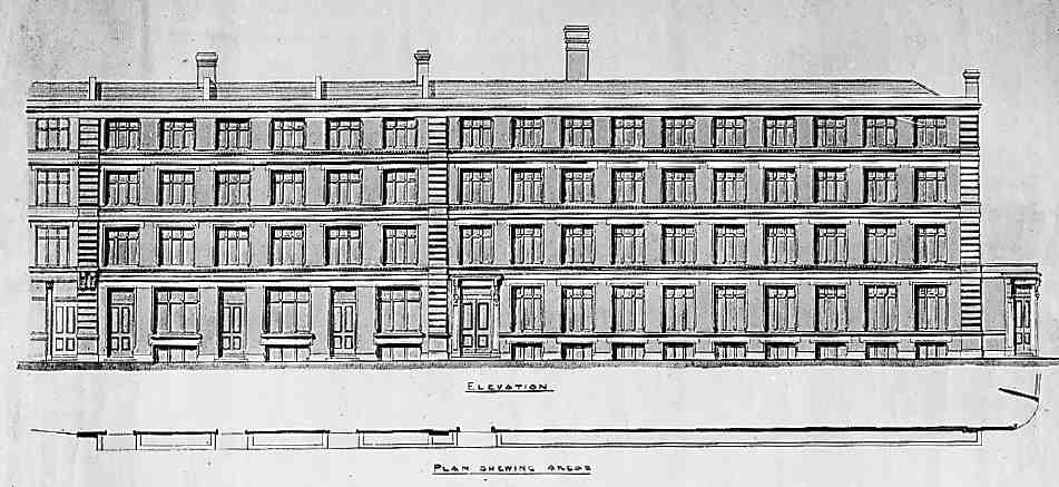
365. Nos 37–40 Charterhouse Square (right to left), elevation by Coutts Stone, architect, c. 1876. Not as built
An early break with residential use on this side took place in 1805, when John Cunningham Saunders, an ophthalmic surgeon of Guy's Hospital, took a lease of No. 40 in order to open a dispensary 'for curing Diseases of the Eye and Ear'. Treatment was quickly limited to eye diseases and Saunders converted the dispensary into an infirmary, renaming it the London Infirmary for Curing Diseases of the Eye. This was the precursor of Moorfields eye hospital. (fn. 142) In 1830 Lady Ann Packington's School took over the site of the coach-house at No. 41 after its premises in Bartholomew Close had burnt down. But in 1852 an inspector concluded that 'the School Buildings are altogether unsuited for the purposes to which they are applied'. The school left eight years later. (fn. 143) By then the building had acquired the number 42 in the square. After use as a manufactory it returned briefly to educational use as St Sepulchre's Schools in the early 1870s. (fn. 144)
Nos 33–43
The Metropolitan Railway acquired the whole of the south side of Charterhouse Square and emptied the properties in order to construct their extension from Farringdon to Moorgate in 1864–5. The cutting of the railway entailed the demolition of Nos 32–38 on the south side of the square, along with the whole of Thomas Neale's Charterhouse Street. Nos 39–43 were briefly left standing, but the operation left the whole south side as an awkward set of narrow sites whose amenities were further diminished by the new east—west thoroughfare completed in front of them in 1873–4 (Ill. 338).
In 1875 the railway company sold the whole frontage to Tubbs, Lewis & Co., manufacturers of elastic fabric, silk throwsters, warehousemen and 'smallware agents', with premises in the City, Birmingham and Manchester, and a manufacturing base in Gloucestershire. (fn. 145) The firm also had a line in the speculative building of warehouses at this period, on which they spent about a quarter of a million pounds. The row which they erected here was one of several local developments they carried out during the mid-1870s, including Charterhouse Buildings at the corner of Goswell and Clerkenwell Roads (see page 390). The company chose as its architect Coutts Stone, a friend of George Devey. Early drawings suggest there was some thought of rebuilding from No. 38 eastwards with houses (Ill. 365), but in the event the whole block became warehousing. Construction took place in 1876–7. Andrew Killby was the builder for Nos 33–42, with interior structural ironwork provided by H. Young & Co.; Scrivener & White took on the separate No. 43. (fn. 146)
Nos 33–42 (Ill. 341) stand four storeys above a basement protected by heavy iron railings. The block is divided into three sections. The front elevation, faced in red brick, has a strong horizontal emphasis, with broad banks of mullioned windows relieved by some minor brick detailing. No. 43 has a narrower frontage and an extra storey topped by a pediment, while its main windows are of iron and flanked by decorated pilasters.
Tenants for these warehouses were mainly involved in the textile trades. At No. 41 one of the original occupants was Griswold & Hainworth Ltd, early specialists in portable knitting machines for domestic use. (fn. 147) In the early 1890s the whole of No. 40 was occupied by David Marcus, importer and agent of Eastern manufactured goods: 'The basement is reserved as a show-room for Oriental carpets and furniture; the ground floor is divided in front into a splendid show-room, and at the rear forms the wellappointed office; while the upper floors are fully utilised as show and stock-rooms'. (fn. 148) In 1917 No. 42 became the first premises of J. Collett Ltd, ladies' hat makers; they gradually took in Nos 41 and 43 and spread elsewhere in the square. The projecting clock which survives at No. 43 was put up by them in 1930. (fn. 149) Though there were still four clothing firms here in the mid-1970s, there had been a shift towards printing, illustration and white-collar work. (fn. 150) Since then most of the row has been fitted out as offices and studios, including No. 41 by Campbell Zogolovitch Wilkinson Gough (CZWG) in 1980 for the pop artist Allen Jones. (fn. 151)