Survey of London: Volume 47, Northern Clerkenwell and Pentonville. Originally published by London County Council, London, 2008.
This free content was digitised by double rekeying. All rights reserved.
'Pentonville Road', in Survey of London: Volume 47, Northern Clerkenwell and Pentonville, ed. Philip Temple (London, 2008), British History Online https://www.british-history.ac.uk/survey-london/vol47/pp339-372 [accessed 30 April 2025].
'Pentonville Road', in Survey of London: Volume 47, Northern Clerkenwell and Pentonville. Edited by Philip Temple (London, 2008), British History Online, accessed April 30, 2025, https://www.british-history.ac.uk/survey-london/vol47/pp339-372.
"Pentonville Road". Survey of London: Volume 47, Northern Clerkenwell and Pentonville. Ed. Philip Temple (London, 2008), British History Online. Web. 30 April 2025. https://www.british-history.ac.uk/survey-london/vol47/pp339-372.
In this section
- CHAPTER XIV. Pentonville Road
- North side: Islington High Street to Baron Street
- Baron Street to Penton Street
- Penton Street to Rodney Street
- Rodney Street to Calshot Street
- Calshot Street to Northdown Street
- West of Northdown Street
- South side: St John Street to Claremont Square
- Claremont Square to Penton Rise
- Penton Rise to King's Cross Road
CHAPTER XIV. Pentonville Road
Pentonville Road was created as the eastern third of the New Road from Paddington, opened in 1756 to divert livestock drovers from the West End and Holborn on their way to Smithfield. Pentonville did not then exist. The road from Battle Bridge (the future King's Cross) passed by fields and bowling greens before reaching the Angel Inn, where Islington High Street gave way to the still-rural road (now the upper half of St John Street) running south towards Smithfield and the City. By the time this part of the New Road received its present name, in 1857, Pentonville was a long-established suburb. Pentonville Road itself, developed as a good-class residential address from the 1770s to the 1820s, was filling with shops and lodging-houses, its population becoming poorer and more numerous. The fields south of Pentonville had been completely built up for many years and, while the livestock market at Smithfield had yet to close, Pentonville Road was no longer a mere bypass but an integral part of the northern metropolis.
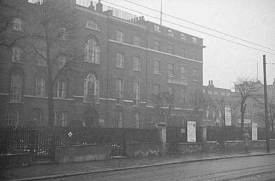
The road today has no defining characteristic, beyond the heavy traffic thundering up and down 'Pentonville Hill', as the descent from Claremont Square towards King's Cross was known before the New Road was formally renamed. At the east end enough late Georgian houses survive to evoke something of its former suburban character. Elsewhere, a very few scraps of the original development are left, together with some Victorian shops and dwellings. Only towards the junction of King's Cross Road is it still recognizably the place detailed by John O'Connor in his well-known sunset view of St Pancras Station (Ill. 429).
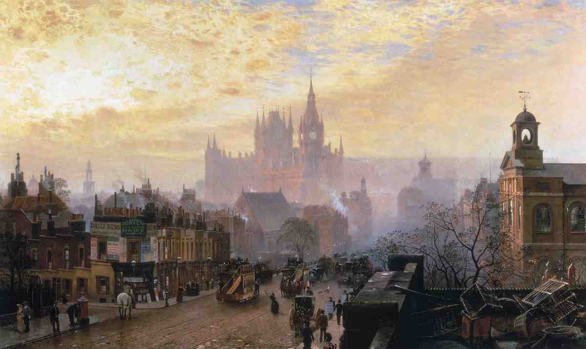
429. 'From Pentonville Road looking West: Evening', by John O'Connor, 1884. On the right is St James's, Pentonville, on the left are Penton Place (now Penton Rise) and the shops of the former Lower Queen's Row. The view appears to be taken from the roof of Dunn & Hewett's cocoa factory (right foreground)
Industrial and commercial buildings, often on a larger scale, replaced many of the original houses from the later nineteenth century. Many of these have themselves been demolished or, if not, converted to new uses. Redevelopment from the late twentieth century, much of it on a fairly large scale too, has moved from offices in the 1970s and 80s to apartment blocks in recent years— especially in the form of student hostels (see Ill. 428, page 337).
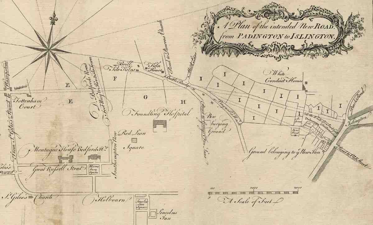
430. The New Road. Extract from a map of 1755, showing the proposed route from Tottenham Court to Islington High Street, with alternative lines east of Battle Bridge. Land owned by Henry Penton labelled 'I'
The present chapter recounts the development of Pentonville Road generally, and describes particular buildings roughly as far west as the parish boundary of St James, Clerkenwell (see Ills 426–7). The short section of the south side west of King's Cross Road, and the buildings west of No. 270 on the north side, including the whole frontage from Caledonian Road to York Way, are therefore not included.
Planning and construction
At the time of its creation in 1756, and for long after, the New Road was unparalleled in London as a piece of largescale road-planning. (fn. 1) The precursor of later bypasses and ring-roads, it retained a separate identity until 1857. By then, as building development had taken place, it had become divided into an unwieldy series of Rows, Terraces and Places, all of which were abolished in 1857 when the Metropolitan Board of Works renamed and renumbered it in three parts as the Marylebone, Euston and Pentonville Roads. (fn. 2)
The New Road was planned to start from the junction of the Harrow and Edgware Roads in Paddington, leading north-east more or less in a straight line to Tottenham Court and thence to Battle Bridge. Finally, with a turn to the south-east, it was to cut through fields belonging to Henry Penton MP, ending near the Angel, Islington. This last stretch had two possible routes: one through the middle of Penton's estate, between the bowling greens there and White Conduit Fields to the north, to join the south end of Upper Street near the junction with what is now Liverpool Road; the other mostly keeping to the south side of his estate, past the New River Company's upper reservoir, and on to the Angel itself (Ill. 430). Penton held 'very great Objections' to the former route as 'detrimental' to his property, but none to the latter, which was the one eventually selected. (fn. 3) The prospect of lucrative future building development was presumably not in Penton's mind, for he thus gave up an outstanding opportunity to maximize his frontages to the new road.
A broad, relatively straight thoroughfare such as this, it was argued, would connect with all the main roads leading south into London, and would provide a direct link between the western and eastern extremities of the metropolis. Gentlemen and men of business could then travel quickly by carriage between City and suburbs without being 'jolted three miles over the stones, or perhaps detained three hours by a stop in some narrow street'. (fn. 4) The road would also help deal with the additional traffic expected to follow the proposed new bridge at Blackfriars (built in the 1760s). In times of emergency, troops would be able to cross London unhindered without entering the centre. But above all it was as a way of taking the twice-weekly flood of sheep and cattle bound for Smithfield away from Oxford Street and the narrow, winding route further east that the New Road was built. That is why it stopped at the Angel, where the Islington road and St John Street provided a direct way south to the market, rather than going on into the City.
The promoters were landowners, farmers, merchants and tradesmen living in and around London—'gentlemen of the greatest eminence and property'. (fn. 5) Though the twenty-five individuals who petitioned Parliament for an enabling Act are not known, some prominent figures can be identified, mostly from among the trustees of the St Marylebone and Islington Turnpike trusts, the two existing bodies that were given the responsibility of constructing and maintaining the road. They included Hammond Crosse, of the Bedfordshire and Clerkenwell brewing family; Richard Whishaw, a Lincoln's Inn attorney and Secretary to the Committee of Gentlemen Practitioners; and George Errington, a landowner in Middlesex and Essex and later High Sheriff of London. (fn. 6) Throughout the committee stage in Parliament the petitioners' interests were represented by an agent, William Godfrey—perhaps William Godfrey of Paddington Green (d. 1766), who had estates in Middlesex and Essex. (fn. 7) Crosse, Whishaw, Errington, Godfrey and Charles Dingley were all on the special committee of twenty-one Islington turnpike trustees set up in May 1756 to manage the making of the road between Tottenham Court and the Angel. (fn. 8)
The 'great projector' (fn. 9) Dingley (d. 1769) is generally credited with the leading role. He and his brother and partner Robert, an architect and philanthropist, had made their fortunes years before, trading with Russia and Persia. (fn. 10) In his evidence to the Parliamentary committee in February 1756, Dingley predicted that the road would be 'one of the most profitable Undertakings he ever knew', offering to put up £1,000 to pay for toll-houses. (fn. 11) He was also behind the creation of City Road in 1761, which carried the New Road on into the City, and projected two more, ultimately unexecuted, roads—an extension of the City Road to the Mansion House, and another linking the New Road with Camden Town. (fn. 12)
When the plan was before Parliament it met opposition from landowners along the proposed route and some of the Islington turnpike trustees, who argued that the existing roads were adequate. The Duke of Bedford protested that dust from the road would affect his land immediately east of Tottenham Court, inconveniencing his tenants, while any roadside building would block the view from his residence, Bedford House—prompting Horace Walpole to remark that the Duke rarely came to town and anyway was 'too shortsighted to see the prospect'. (fn. 13) Wider opinion was supportive. The Gentleman's Magazine stressed the primacy of public over private interests, asserting that 'streets and roads are to inland trade what seas are to foreign', every new road being a 'kind of new mine that encreases the wealth of the community'. (fn. 14)
The Act was passed in May 1756 and the two turnpike commissions immediately set about marking out the route. (fn. 15) In the Clerkenwell section, several surveyors were involved. A preliminary survey and plans had been provided by Edward Cullen, who was paid six guineas in August 1755. (fn. 16) Paul Jollage, surveyor, was paid five guineas for his 'trouble' in planning the road, and a land surveyor named Marsh provided plans and property information for both the Islington and Marylebone trustees. (fn. 17) Labourers working on the road were supervised by the Islington trust's surveyors William Thomas and James Inglish. (fn. 18)
Construction was largely confined to the removal of hedges and banks to make a sufficiently level surface, the digging of ditches, and the erection of fences, gates and toll-houses—mostly from old ships' timbers. As the road was to be used particularly by drovers, the enabling Act forbade the paving of the surface, which was left as turf. However, the pot-holes caused by heavy rain and workmen's carts had to be filled with gravel or ballast, and this was eventually extended over the whole surface. (fn. 19) As early as 13 September 1756 coaches, carriages and horsemen were passing daily in 'great numbers' over the road from Islington to Battle Bridge, and the whole route was opened four days later. (fn. 20)
Compensation had to be paid to landowners and leaseholders, not just for the 40 ft width of the road itself, but for another 10 ft each side for ditches and fencing. An important clause in the Act, never wholly obeyed, forbade building within 50 ft of the road, to admit enough sun and air to keep it dry, and to stop dust from inconveniencing residents. (fn. 21) Henry Penton gave up part of the western bowling green and the 'Bowl house' there, in return for a larger building, with a room over, designed and built by Woodhouse Coker, the turnpike trustees' carpenter. Robert Bartholomew, landlord of the Angel, whose sheep pens stood on the route, asked for money towards replacements; and the New River Company was given £150 towards building a brick wall on the north and west sides of its Upper Pond reservoir. (fn. 22)
Early development
It was some years before building development took off along the New Road east of Battle Bridge. Until then, the ground on either side remained in use chiefly for grazing. The opening of the road must have increased the demand hereabouts for sheep and cattle lairs (or layers), where animals were kept for fattening before going on to market. Parts of the ground, including the Penton estate, continued to be dug for gravel and clay for making bricks and tiles, an activity which went back in this area to the seventeenth century at least. (fn. 23) The road was, at first, rather too far from the built-up area to attract builders, and in any case its opening coincided with bad harvests, the onset of the Seven Years War, tight credit and a downturn in house-building. (fn. 24) But by the late 1760s the picture was changing, and leasehold development was taking off along the New Road.
Building on the Penton-owned frontages was slow. Henry Penton III (d. 1812), who oversaw the development of Pentonville, inherited the estate from his father in 1762. His first attempt at leasehold development seems to have been in 1764, when a St Marylebone plasterer, William Lloyd, agreed to build houses on the south side of the road west of the reservoir. (fn. 25) This proved a false start, but in 1767 the Belvidere tavern was built on the north side, on the corner of the new Penton Street (see page 351). (fn. 26)
Houses near by, on both sides, in King's Row and Queen's Row followed from the late 1760s. By the late 1780s development had spread some way east and west of this nucleus. On the north side, Pleasant Row and Pleasant Place, west of Southampton (now Calshot) Street, went up about 1783–7. (fn. 27) The late 1780s saw the building of Pentonville Chapel and a large detached residence, Cumming House, and houses in Cumming Place. (fn. 28) East of Penton Street, Winchester Place and the Penton Arms on the corner of Baron Street were built in the late 1780s. On the south side, the triangle bounded by Penton Place (now Penton Rise) and Hamilton Row (now part of King's Cross Road) was mostly built up in the late 1780s and 90s, after some earlier building on the east side of Penton Place (see Ill. 528 on page 406).
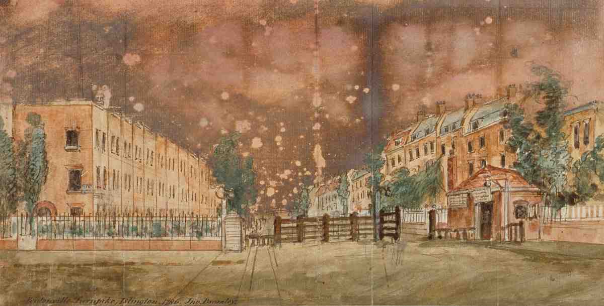
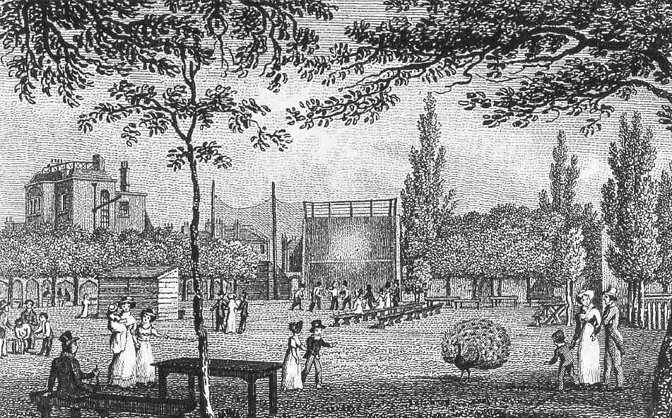
431. The New Road, looking east past the turnpike gate at the junction with Penton Rise, 1786. On the left are houses in King's Row, on the right part of Queen's Row
The last part to be developed was to the east, on the New River Company's estate and land formerly belonging to the Angel inn. The frontages here were filled with houses from about 1818 until the mid- 1820s: Angel Terrace and Claremont Terrace on the south side, Angel Place and Claremont Place, together with Claremont Chapel, on the north.
Though differing to a certain extent in size and layout, nearly all this first-generation building consisted of goodclass private houses. Most were three storeys high, with two-bay frontages, though there were exceptions, notably some four-storey houses in Winchester Place, Claremont Terrace and Claremont Place (Ills 431–4, 439, 445). There were at least two houses of only two storeys (Nos 62 and 64). Nearly all had conventional side-passage plans, with two rooms to a floor (Ill. 435). On the north side, many of the houses were raised above the level of the roadway, on semi-basements or basement vaults, and consequently any shops later built out in front usually had steps up at the back.
Why some houses at the west end of Pentonville Road were allowed to be built hard up against the roadway, as at Batchelor Place and Pleasant Place, rather than 50 ft back as required by the New Road Act, is not known. However, none of these early incursions were on the Penton, New River Company or Angel estates. The turnpike trustees' minutes are silent on the matter, so a blind eye may have been turned. By the 1820s some parts of the New Road in and around Battle Bridge had been exempted from the 50ft rule, perhaps retrospectively. (fn. 29)
Changing character
For more than half a century after it was built up, the New Road between Battle Bridge and the Angel was solidly residential and apparently respectable, the address typically of gentlemen and merchants. There were self-styled 'Esquires' in some of the best houses, such as those in Winchester Place and Claremont Place, into the 1860s. (fn. 30) But within a few years of Queen Victoria's accession several houses had become business premises. There were a number of professional occupants, particularly surgeons and physicians, but more often than not some craft or manufacturing activity was being carried on. Directories of the 1840s list an engraver, a chain-maker, two chronometer-makers, a zinc worker, cabinet-makers, printers, and bookbinders. By this date there were also a fair number of shopkeepers and general tradesmen. (fn. 31)
Pentonville Road houses. All demolished
432. Nos 177–183 (formerly part of Clarence Place) in 1964. Part of a development of the 1780s and 90s by John Weston, brickmaker
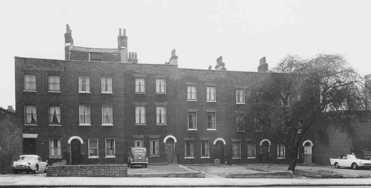
433. Nos 124 and 126 in 1963. Built as part of King's Row, 1770s and 80s
434. No. 56 in 1953. Built as part of Winchester Place, 1786–90
435. No. 9 Claremont Place (later No. 28 Pentonville Road), as built 1822–3. Demolished
Architecturally, this increasing commercialization was manifested in shops, mostly single-storey extensions to houses. But the earliest instance, Athol Place, was a row of two-storey houses with shops, built about 1839 on part of the gardens belonging to the Belvidere. Within a few years more shops had been built on the south side, in Lower Queen's Row, and in front of houses on the north side, in Cumming Place and King's Row (the latter as a continuation of Athol Place). More than half the houses west of Penton Street and Claremont Square had lost their front gardens to shops by the 1870s.
The new Metropolitan Board of Works was at first stringent in refusing forecourt shops, on the grounds that they projected beyond the existing building line, turning down several applications in 1856 and 1857. (fn. 32) The district surveyor, Robert Sibley, who lived in Pentonville Road, told the Board he was unsure if these structures could be classed as projections, and on at least two occasions magistrates dismissed cases he had brought against owners, on the grounds that the shops were buildings in their own right, or additions to buildings, and not projections. (fn. 33) In neither case was mention made of the 50 ft rule, which had been reaffirmed by the Metropolis Turnpike Road Act of 1826. (fn. 34)
Subsequently, in the 1860s–80s applications to build shop-additions were generally allowed by the board. But in 1887 they were refused at the former Winchester Place opposite Claremont Square (Nos 56–92), perhaps on account of its superior architectural character or setting, as effectively the fourth side of Claremont Square. (fn. 35) Nor would the New River Company permit them on its own Pentonville Road frontage. By 1900 only a few houses on the Penton frontage still kept their gardens, including Winchester Place. On the north side of the road east of the Penton estate Nos 14–44 never acquired shops, but some later had workshops built over the rear gardens, as with Betjemann & Sons' works at Nos 34–42.
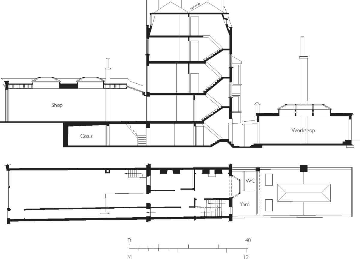
436. No. 178 Pentonville Road in the 1930s. Section showing characteristic arrangement of house with later shop and workshop additions to front and rear
As well as shops, rear workshops became common in the mid-to-late nineteenth century, as the character of the road became increasingly industrial, in many instances leaving the old houses sandwiched between long, low structures (Ill. 9). In some cases two, three or more adjoining hybrid house—workshops of this sort were acquired and thrown together to form an extensive factory, as at Dunn & Hewett's cocoa factory, at Nos 130–138.
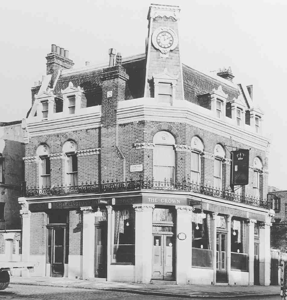
437, 438. Pentonville Road pubs: Lord Vernon Arms, No. 188 (left), rebuilt 1901; Crown, No. 128a, rebuilt 1873 –4. Both demolished
During the 1870s and 80s more and more premises were given over to light manufactures of various sorts, including musical instruments, furniture, jewellery, and artificial flowers. Several photographic studios were also established. From the outset there had been a number of taverns, and by this period there were numerous coffeeshops and dining-rooms, no doubt to a great extent catering to workers in the many factories and other establishments. (fn. 36)
Most of the public houses in Pentonville Road were rebuilt in the late nineteenth and early twentieth centuries. Though none were of the scale and elaboration seen in better-heeled areas, there were some quirky designs, such as the Crown at No. 128a (1873–4), with an obelisk-like clock-tower on the corner (Ill. 438). (fn. 37) Another early rebuilding was the Italianate-style Belvidere (1875–6, see page 352). The Welsh Bull at No. 120 was enlarged in 1881 and remodelled internally in the early 1890s (see page 354). Later rebuildings along the north side of the road included the Lord Vernon Arms of 1901 (No. 180, later 188), another showy design with a clock-turret (Ill. 437), and the King George IV of the late 1890s (No. 156), a plainer building with bay windows on the long front to Cumming Street. (fn. 38) Of those mentioned, only the Belvidere and Welsh Bull survive, neither of them now as pubs.
Though there was already much poverty in the area, Pentonville Road received a sharp jolt in the early 1900s, one of the chief factors being the introduction of trams, which brought about an unprecedented degree of mobility among the working-classes. Better shops and better lodgings were easily found elsewhere. Writing to the London County Council in 1908, H. C. Braun, proprietor of an experimental engineering works at Nos 236 and 238, claimed that some 60 per cent of local shops had closed. His claim is supported by the records made four or five years later by Inland Revenue valuers. Many of the forecourt shops were dilapidated, devalued and untenanted. (fn. 39) Braun himself planned (unsuccessfully) to build bigger premises, which he hoped would make a 'good entrance' at the road's west end and help it recover from its 'bankrupt' condition: only redevelopment with large factories could save Pentonville Road from becoming 'a scandal and disgrace to London'. (fn. 40)
So it proved. Pentonville Road in the first two-thirds of the twentieth century saw redevelopment with a number of large warehouses and factories, and a general decline in the resident population. One of the largest developments was the depot built for the shoe company Lilley & Skinner. The Ormond Engineering Co., based in Holford Mews, built the large factory-warehouse at Nos 91–99 in the late 1930s, and another at No. 189 in the 1950s. Dunn & Hewett expanded their premises. There were also new workshops on a smaller scale, in speculative blocks of the 1930s and, more modestly, in the conversion of houses and shops for manufacturing of all kinds. Makers of weighing machines, electric lamps, toy-eyes, amusement machines, rubber jointings, toilet brushes, band saws, tin boxes, typewriters, motor radiators, billiard tables, Christmas crackers and toffee—all could be found on Pentonville Road in the 1930s and 40s. (fn. 41)
After the Second World War, bomb damage and general obsolescence left parts of the road badly in need of renewal. By the 1950s and 60s, municipal housing developments were transforming the Pentonville hinterland to the north, but Pentonville Road itself was reserved for business use, apart from the triangle between Penton Rise and Weston Rise, where the Weston Rise Estate was built in the mid-to-late 1960s (see page 319).
The road maintained its mixed but predominantly industrial character until the depression years of the 1970s, mostly through the efforts of local planners. The London County Council had been trying after the war to prevent industrial expansion in central London, but by the 1960s Finsbury Borough Council was doing all it could to retain light industry, rejecting proposals in 1962 for offices on a bomb-damaged site at Nos 210–234, which remained vacant for several years, when a scheme for warehousing was accepted. (fn. 42) This policy continued under Islington Council, Finsbury's successor.
By the 1970s it was unworkable, and with so much of the road in decay the pressure to allow offices became irresistible. The Sterling Land Co. was given the go-ahead for two large office towers, King's Cross House, begun in 1973. Islington councillors subsequently expressed regret at having endorsed such an architecturally monstrous scheme. At the other end of the road property had been blighted since the war by LCC and then Greater London Council plans to widen the Angel intersection. This scheme was shelved in 1975, and in 1978 Islington Council permitted London Merchant Securities to build the Angel Centre offices on the corner of St John Street.
In general, however, Islington continued to resist officebuilding, even though refusals were likely to be overturned on appeal, as at Nos 207–221 in 1979–a time when the GLC was favouring office developments near major railway stations; and again at the Angel in the 1980s, where initial attempts to prevent London Merchant Securities building offices on the north side of the road failed. (fn. 43) The developers' vision of Pentonville Road as a 'golden mile' of office blocks ultimately faded. Since the early 1990s the main redevelopments here have been for residential buildings in one form or another including private flats and a hotel. West of Penton Rise there is now a concentration of student apartments, including the former office-towers of King's Cross House.
North side: Islington High Street to Baron Street
Apart from a small portion belonging to the Penton estate at the corner of Baron Street, the frontage here was part of the land belonging historically with the Angel. The story of the old coaching inn itself and the surviving former public house of 1899 (No. 2 Pentonville Road) is given in Chapter XVII.
439. Nos 34–44 Pentonville Road (right to left), formerly part of Claremont Place, in 2007
The Penton ground was built up in the late eighteenth century, but development of the Angel property did not take place until later. It was probably held up by a protracted Chancery suit, settled in 1817 with the division of the ground between several claimants. On this north side of the road the Angel and some 350 ft of frontage went to the Rev. William Coxe, historian and Archdeacon of Wiltshire, his family and associates. The remaining 200 ft of frontage to the west went to William Dyke Whitmarsh of New Sarum, Wiltshire; Martha Young (widow of William Young, the original plaintiff), and one Sarah Foster. (fn. 44)
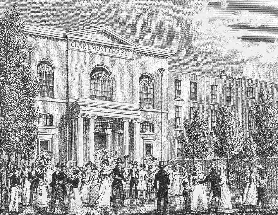
All soon set about letting their ground for building. (fn. 45) Angel Place (later Nos 2–12 Pentonville Road), a short row of houses adjoining the Angel inn, was built c. 1818–21, Claremont Chapel in 1818 and half of Claremont Place (later Nos 30–44) c.1819. The remainder of Claremont Place (later Nos 14–28) followed over the next six years or so. (fn. 46) (Older houses on the Penton estate west of the chapel were also at one time numbered in Claremont Place.) (fn. 47)
These houses, mostly of four storeys over basements, may have been designed by the architect and surveyor Henry Rhodes, who is known to have acted professionally for the Coxe family elsewhere, and was a party to the conveyance of the Angel estate. (fn. 48) Private stabling, a rarity along Pentonville Road, was provided for Claremont Place in Angel Mews; a stable-yard behind Angel Place was reserved for the use of the inn. Builders and first lessees included Charles Douglas, gentleman, of Chapel Street (Chapel Market); Matthew Elwall of St Giles-withoutCripplegate, painter and glazer; and John Reynolds, painter, of City Road. Many seem to have been involved at the same time with Thomas Richard Read in building Claremont Terrace opposite. (fn. 49)
Of the original houses, a few remain in what was Claremont Place (Ill. 439). Nos 42 and 44 in particular, with their long front gardens and curving steps up to the raised ground floors, preserve an impression of the road's sometime character. Claremont Chapel adjoining was externally embellished later in the century.
440. Former workshops of G. Betjemann & Sons at the rear of Nos 34–42 Pentonville Road; former Claremont Chapel and part of Claremont United Reformed Church buildings, White Lion Street, at right
Early occupants were mostly gentlemen, clerics or men of business. (fn. 50) They included, in the early 1820s, Thomas Arrowsmith, proprietor of John Bull, and Richard Barlow, a bill-broker. (fn. 51) From the outset not all of the houses were in single occupation, rooms or floors being offered to 'highly respectable' lodgers. (fn. 52)
Angel Place was partly in commercial or industrial use by the early 1840s. The business of Alfred Syer, builder's ironmonger and glass-merchant, remained from about 1853 until the 1960s, at one time occupying several houses. (fn. 53) Many coal-hole and manhole covers in the vicinity carry his name. Claremont Place remained largely residential well into the 1870s, though by the 1860s jewellers and other craftsmen were living and working here, including, from 1859, G. Betjemann & Sons, makers of dressing-cases and other specialist cabinetwork, at No. 36.
This well-known firm, established in the 1830s in Upper Ashby Street off Northampton Square, developed a range of luxury goods in metal and wood meeting the requirements of the very top end of the market. One of its most successful products, patented in 1881, was a decanter-holder called the Tantalus, designed to prevent pilfering by means of a lockable bar over the stoppers. The firm acquired a greater, posthumous, fame through (Sir) John Betjeman, great-grandson of the founder, who disliked and despised the business and, having refused to take on the mantle of fourth-generation boss, closed it down in 1945. By that time the firm occupied Nos 34–44, and had covered the back gardens with workshops (Ills 439, 440), recalled by Betjeman in Summoned by Bells. At the front, an alteration made by Betjemanns was the creation in 1927 of the curved in-and-out driveway at Nos 34–40, with iron gates under overthrows with lamps. Herbert Wright acted as architect. The gates and the front railings have now gone. (fn. 54)
After Betjemanns went into liquidation, Nos 34–42 were taken over as the head office of the fine-art publishers the Medici Society, who remained until 1999. (fn. 55) Relics of the buildings' past were still evident in the early 1990s, including etched glass in the doors to the old showroom and counting-house (Ill. 441). The buildings are unoccupied at the time of writing (2007).
Nos 20–32, Angel House, was built in 1934 by Ansel Blaustein of Angel Estates, Pentonville Road, father of the property developers Cyril and Leonard Blaustein or Blausten. The architect was Leonard Blaustein, and the builders were named as Leonards Ltd. (fn. 56) A six-storey block, faced in red brick with a stone cornice, it comprised shops and workshops with dwellings above. Many of the workshops were converted to offices and self-contained flats in the mid-1980s. (fn. 57)
The two dark-glazed office blocks on the east side of Angel House were built in the 1980s by London Merchant Securities, the developers of the Angel Centre opposite. All three were designed by Elsom, Pack & Roberts (now EPR Architects). (fn. 58) Nos 2–12, built in 1985–7, was first occupied by the life assurance company Aetna UK Ltd. No. 14 followed in 1988–9, after an appeal against the refusal of Islington Council to allow a tall office building on the site, then occupied by three listed houses. At the appeal, the Department of Environment Inspector, disagreeing with the council, cited the increasing popularity of the Angel area for offices, and predicted that in years to come the old houses, if retained, would seem out of place, 'preserved out of misplaced sentiment'. (fn. 59) The new building was let in 1990 to British Rail's Freight Division. (fn. 60)
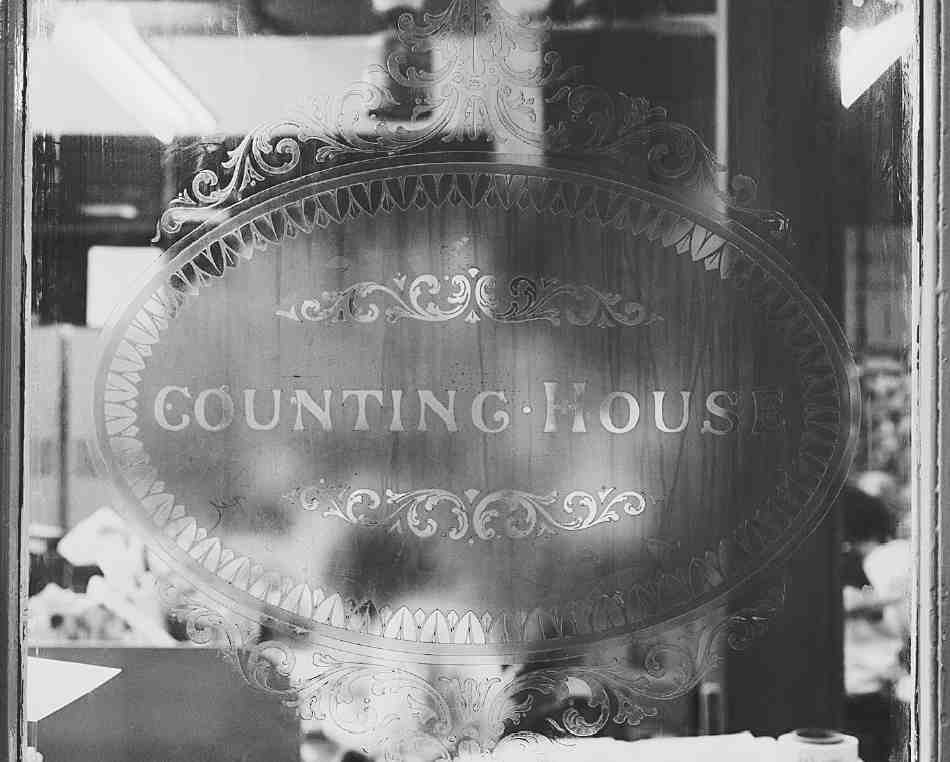
441. Nos 34–42 Pentonville Road: detail of door to former counting-house of G. Betjemann & Sons, in 1996
West of the former Claremont Chapel, Nos 46–52 is a 1990s office redevelopment in pastiche Georgian style. Previously the site had been occupied by dwelling-houses with, at Nos 46 and 48, a yard with a coach-building works and livery stables, built around 1820 by William Argent. (fn. 61) More than a century later, Henry Argent was trading here as a house agent and valuer. (fn. 62) The yard is now named Freeman Mews, after Albert Freeman, a horse-dealer who took over most of the property in the 1920s.
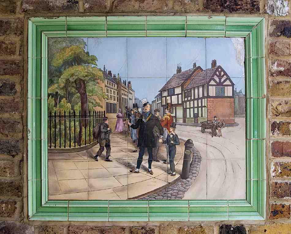
442. Tile panel picture, 1920s, from Freeman's stables, Nos 46–48 Pentonville Road (demolished), re-erected in Freeman Mews
Set in the walls of the new passageway to Freeman Mews is a series of coloured tile-pictures from the earlier buildings, showing hunting and other old-time scenes, including one or two probably of characters from Dickens in the Clerkenwell area (Ill. 442). These were presumably made for Freeman, whose name appears on a facia-board in one of the pictures. (fn. 63) The small factory-workshop at the back of the yard was built for Freeman in 1936 to the design of Herbert Wright. (fn. 64)
On the corner of Baron Street, No. 54 was built about 1789 as the Penton Arms public house. Much altered and extended, it has been called in recent years the Pint Pot and is now the Castle. The architects Finch Hill & Paraire did some work here in 1862, and in the early 1890s the long ground-floor extension was refitted by John Cox Dear, architect, with a series of small private bars or booths and a larger saloon bar at the north end. The chimney stack dividing the front of the main building dates from Dear's remodelling, and was built to provide a fireplace in the saloon. (fn. 65)
No. 44A, former Claremont Chapel
Claremont Chapel was one of several Independent or Congregationalist chapels built in London and the provinces by Thomas Wilson of Highbury, a former silk mercer and ribbon manufacturer, who was also active in the founding of the University of London and the London Missionary Society. During the early 1800s he was busily engaged in chapel-building in the emerging suburbs, to cater for London's expanding population, and funded two other chapels on the New Road—at Tonbridge Place in Marylebone, and at the Paddington end, in Homer Place. (fn. 66)
Wilson had acquired the freehold of a two-acre site on the New Road in Pentonville in 1818 from Martha Young and her family, for about £700, before laying out nearly £6,000 in building the chapel on part of it. The remainder of the site was let for development as Argent's livery stables (above). Included in these costs was £203 17s 8d to a Mr Wallen 'for surveying', almost certainly a reference to William Wallen (d. 1853), a surveyor then based in Finsbury, who is known to have designed two Nonconformist chapels of the early 1820s at Newbury in Berkshire and Newark, Nottinghamshire. Wallen's substantial fee perhaps included the design of the chapel and other work to do with its construction. (fn. 67)
Claremont Chapel, which took its name from the Surrey residence of the recently deceased Princess Charlotte Augusta, was opened for worship in October 1819. Various prominent Congregationalist ministers attended the first service, including Thomas Lewis of the Union Chapel, Islington, John Morison of the Union Chapel in Sloane Street, Chelsea, Thomas Raffles of Liverpool, and John Leifchild, the latter two preaching on the day. However, it was not till March 1820 that an Independent congregation was established here, and October 1822 before a resident pastor was appointed—the Rev. John Blackburn, formerly of Finchingfield, Essex. (fn. 68)
443. Claremont Chapel, c. 1828. William Wallen, architect, 1818–19
Wilson's chapels were designed on functional lines to hold large congregations, and Claremont in its original form was externally spare of detail, except for an Ionic entrance portico (Ill. 443). But it was wellproportioned, and given additional gravitas by standing slightly higher than the road, behind neo-Classical iron gate-piers and railings. The interior, which could hold 1,500 worshippers, attracted attention for the arrangement of the gallery, which ran continuously around all four walls on thin iron columns, forming an oval well. There were also 'light and elegant' upper galleries for Sunday school children. (fn. 69)
444. Former Claremont Chapel, No. 44a Pentonville Road, in 2007
Various alterations and repairs were made during the 1840s, and in 1847 a Sunday school was added at the rear. (fn. 70) Sash windows of wood and cast-iron were installed in the galleries in 1853–4, under the supervision of Henry Owen, a surveyor of Great Marlborough Street, who went on to re-glaze most of the building. In 1854–5 Owen improved the approach to the chapel by adding a stuccoed balustraded terrace either side of the entrance steps (Ill. 444). (fn. 71)
Externally, the building's present appearance owes much to alterations made in 1860, for which money was raised at a three-day bazaar, held at Myddelton Hall, Islington, under the patronage of the contractor Sir (Samuel) Morton Peto and his wife. (fn. 72) The formerly plain brick façade was stuccoed over and enriched with Classical details. Inside, the gallery—inconvenient to those who sat behind the minister—was reduced to three sides. (fn. 73) Some, if not all of these alterations were the work of an architect referred to at the time as 'Mr Tarry'—perhaps John Tarring, a London architect who specialized in Nonconformist chapels. (fn. 74)
Poorly attended and short of funds by the 1890s, the chapel was sold to the London Congregational Union for use as a Mission Station for the increasingly distressed Pentonville district, closing in 1899. It was altered in 1902 for a new role as the Union's Central London Mission. The upper galleries were removed and the chapel became Claremont Hall, part of a mission institute developed over the next few years to the north, on White Lion Street (see page 387). (fn. 75) It was probably then that the side entrances were given their round-headed doorways with open pediments on consoles.
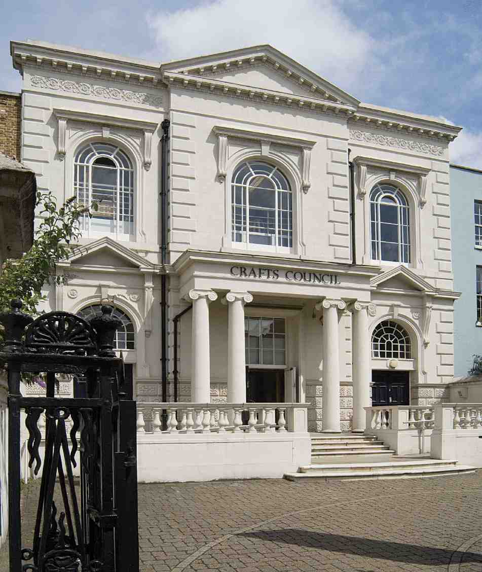
By the early 1960s Claremont Hall had been let by the mission for commercial use. It has since been sub-let to the Crafts Council, re-opening in 1991 after conversion to a white-walled exhibition space (designed by Barry Mazur), with a library and offices above. (fn. 76) In 2006 the Crafts Council closed the gallery to concentrate on 'developing national initiatives with partner organizations'. The building was refurbished over the next two years and now provides an improved research library and resource centre. (fn. 77)
Baron Street to Penton Street
This part of the road was built up with terrace-houses in the late 1780s under the name Winchester Place, and these survived essentially intact until the 1930s (Ill. 445). By then they had long ceased to be private residences, and were mostly in commercial use, ranging from artistic lampshade manufacture at one end (No. 58) to marble masonry at the other (Nos 88–94). None were shops. An application had been made in 1887 to build over the forecourts with shops, as elsewhere in the road, but was refused by the Metropolitan Board of Works. (fn. 78) Some redevelopment occurred in the late 1930s, with light-industrial premises at Nos 90–92 and 86–88, and continued after the war. The last remaining houses were demolished in the 1990s.
Winchester Place (demolished)
Winchester Place was built in 1786–90 on the southern part of the site of Dobney's bowling green (page 327), taking its name from the home town of the Pentons. (fn. 79) The houses here became Nos 56–92 Pentonville Road; No. 94 was originally numbered in Penton Street and was not strictly part of Winchester Place; the site is now subsumed in Nos 90–92.
It was not a uniform development. On the corner of Penton Street, the sites of Nos 90–94 were a portion of the ground covered by John Pennie's building agreement of 1767, most of which was taken up by the Belvidere on the west side of Penton Street, and the south end of Penton Street itself. A pair of three-storey houses, later Nos 90 and 92, was erected, their relatively broad fronts compensating for the shallowness of the plots, restricted by the gardens of houses in Penton Street. They were later thrown into one with the house at the corner of Penton Street, probably by Henry Webb Wilkins & Son, who were here from the 1860s and built showrooms in front (Ill. 446). This firm specialized in marble for statuary and other purposes, describing themselves in the early twentieth century as marble merchants, general and monumental masons, sculptors, table-top manufacturers, shopfitters and interior decorators in marble and tiles. (fn. 80)
445. Nos 62–70 Pentonville Road (formerly part of Winchester Place), in 1938. Demolished
The main part of Winchester Place, a terrace of twelve houses (later Nos 66–88) overlooking the New River Company's reservoir, was built on ground taken by Edmund Hague, painter and builder, by a building agreement of March 1786; this also took in the Penton Grove site later occupied by White Lion Street School. As befitted the site, 'presumed the most eligible Part of the Penton Estate', Hague's terrace was conceived in terms of some pretension, and the design was probably that shown by the architect Aaron Henry Hurst at the Royal Academy in 1788. (fn. 81) Hague, who was also developing in Chapel Street (Market), went bankrupt about 1789, and it was presumably on account of this that the original scheme was abandoned. Three plots at the east end of the ground, with 20 ft frontages, were let at Hague's direction to the bricklayer Joshua Hodgkinson in February 1787 and built up in the next couple of years, the first two (Nos 66 and 68) apparently as the end 'pavilion' of an unrealized grand terrace, with high, partly balustraded parapets. (fn. 82) The third house (No. 70) was enlarged by the addition of an entrance bay at the side, on extra ground, with Venetian windows. Two or all three were leased to George Fillingham, a St John Street hop-merchant, the largest one becoming his own residence. (fn. 83) Meanwhile the remainder of the terrace was built up on plots with frontages of about 16 ft; these narrower houses were of different design, with lower floor-heights. Five of the nine plots were leased to Francis Abercromby Gray, a surveyor, of Wells Street, Cripplegate, and two others to Edward Tanner, a carpenter of Grub Street in the City, who was involved in the building of Fillingham's house. (fn. 84)
The east end of the terrace was built on ground leased by Henry Penton's steward Thomas Collier in January 1786. The houses were again irregular: narrower, threestorey houses at the Baron Street corner (later 56–60), shorter, broader houses at Nos 62 and 64, the last being Collier's own residence. (fn. 85) He might have been the landlord who had the misfortune to let the house next door (No. 62) to Thomas Cooke, who became notorious as a grasping miser. Cooke, a retired papermaker and sugar-baker, who turned the garden over to cabbages and spent nothing on repairs or decorations, lived there fifteen years before eventually being ejected. (fn. 86)
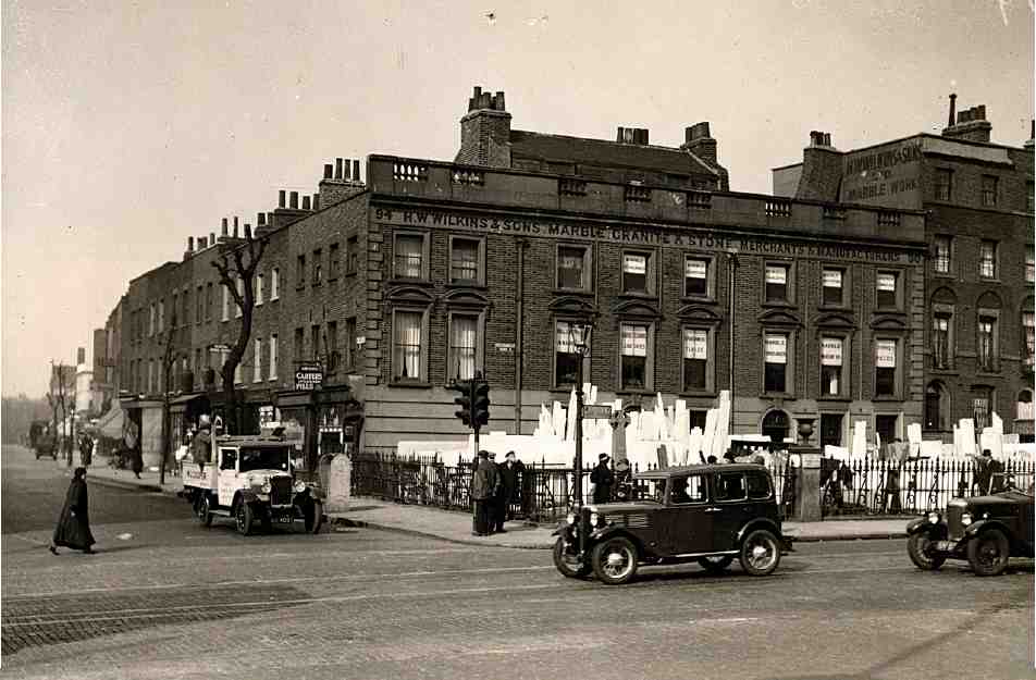
446. Nos 90–94 Pentonville Road, Wilkins' marble works, at the corner with Penton Street, c. 1930. Demolished
Besides Collier, early occupants of Winchester Place included another player in the development of the estate, Henry Penton's lawyer, William Wightman of Lyon's Inn, also Charles Cross, an apothecary, and Henry Batley, a druggist. (fn. 87)
Business use of the houses in Winchester Place began to predominate over residential during the 1850s. Occupations of people working here included bookbinder, professor of music, artificial florist, feather maker, aquatint engraver (Augustus William Reeve), writing master, and net and marquee maker. No. 11 Winchester Place (later No. 72 Pentonville Road) was occupied for several years in the 1850s by the architect E. C. Robins. (fn. 88)
By the 1890s private residents were no longer listed here in the Post Office Directory, and several of the houses (at first No. 74 and subsequently Nos 66, 70, 72 and 80 also) were used as 'Stainer's Homes for Deaf and Dumb Children'. This institution, which also had homes in Paddington Green and Camberwell Green, was run by the Rev. Dr William Stainer, brother of the composer Sir John Stainer. Nos 70–74 were subsequently a remand home of the Metropolitan Asylums Board, later becoming London County Council offices in connection with education and children's care services. (fn. 89)
Illustration 445 shows Nos 66–68 with the signboard of the Cartonite & Arborite Syndicate Ltd, cabinet makers (but latterly 'postal tube makers'), which occupied the premises for many years from 1906. (fn. 90)
Present buildings
Two old houses at Nos 66–68 were refronted and otherwise altered about 1952, but not completely rebuilt, as one building for commercial use; Wright & Tidmarsh were the architects. (fn. 91) This partial survival excepted, the lastremaining houses of Winchester Place were replaced in 1997–8 by a 220-room hotel, the Jurys Inn (Nos 56–64). Built for the Jurys (now Jurys Doyle) Hotel Group (UK) Ltd, this is one of a number in Britain and Ireland designed for this chain by the Consarc Design Group of Belfast and Dublin. (fn. 92) The façade, in stock brick and render, has a central feature of semi-circular steel balconies.
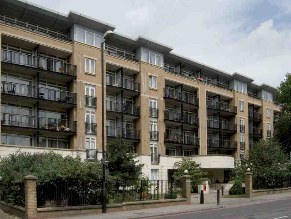
The large site now occupied by Claremont Heights (Nos 70–88) was formerly covered with warehousing built in the 1950s for Henry Righton & Co. Ltd, metal merchants. (fn. 93) Cleared in 1990, it was used as a car park and redeveloped in 1996–7 as private apartments. These were built for Furlong Homes plc to designs by Hazan, Smith & Partners (Ill. 447). In addition to the main six-storey block facing Pentonville Road, two smaller blocks stand in landscaped grounds on the sites of Nos 12–16 Penton Street and 51–53 White Lion Street. All are faced predominantly in stock brick. (fn. 94)
Nos 90–92 was erected in 1936–7 for Brixton Estates Ltd to designs by Lewis Solomon & Son. It seems to have been intended from the start for occupation by the briarpipe makers H. Comoy & Co. Ltd, also at Rosebery Avenue. (fn. 95) Two more bays added in 1938–9 at Nos 86–88 have been demolished. (fn. 96) Occupied for many years by Comoys, the building is now used as offices. It is of five storeys, faced in red brick, and retains its original metal windows.
Penton Street to Rodney Street
From Penton Street to Rodney Street the nature of the buildings still shows quite clearly the effects of Pentonville's decline as a residential suburb. For much of the way the building line has been pushed forward to the pavement edge, with thoroughly urban two-storey shop premises. The former Belvidere public house, rebuilt in the 1870s, conveys no memories of the old Belvidere with its bun-house and tea-garden, and the racket-ground where City men came for outdoor exercise. The shops were built over part of the garden about 1839, and where the building line moves back again, towards Rodney Street, the buildings are mostly modern and industrial in character. Hermes Street, which once offered a glimpse of Hermes Hill and the White Conduit Fields beyond, is now a short cul-de-sac giving access to public housing of the twentieth century.
The Belvidere, built in the 1760s, was one of the earliest developments in the creation of Pentonville, and one that perpetuated the resort character which the hitherto rural district had enjoyed for generations. West of the Belvidere tea-garden, the frontage to the New Road was built up with smallish terrace-houses from about 1770. (fn. 97) These were at first known as Happy Man Row, from a tavern called the Happy Man, and renamed King's Row in 1774 (see Ill. 528 on page 406). The Happy Man was later the Crown, this name being in use by 1795; Hornor's map (1808) shows it as a coffee-house. Dickens sets a short scene there in 'Miss Evans and the Eagle', in Sketches by Boz. (fn. 98)
447. Claremont Heights, Nos 70–88 Pentonville Road, 2007
Development of this part of the road was carried out over a good many years, and under several building agreements or leases. Between the Belvidere and Cynthia (then Ann) Street the ground was part of a large plot initially taken on a building agreement of July 1769 by Robert Harrop, merchant, of Coventry Street, St James's, and later of Paris. Four houses, including the Happy Man, were put up more or less at once, (fn. 99) but no further building took place until about 1786, when Harrop's executor, Charles Harrop, gentleman, of Hammersmith, at last surrendered the 1769 articles so that leases could be granted. Dr De Valangin of Hermes Hill took a lease of a deep plot on the west corner of Cynthia Street in 1776. A decade later the remainder of the block between Cynthia Street and Rodney Street, extending north to Donegal (then Henry) Street, was acquired on lease by the bricklayer John Brown of Holborn and built up. (fn. 100)
448. Nos 96–98 Pentonville Road (former Belvidere public house), 2007. W. E. Williams, architect, 1875–6
Nos 96–98, the former Belvidere, and 1–5 Penton Street
The large Italianate public house on the corner of Penton Street, in recent years called the Finca, was erected in 1875–6 as the Belvidere, replacing the earlier tavern of that name on the site. It was designed by the architect W. E. Williams and built by Robert Marr and is constructed of white brick with sparing stone or cement dressings (Ill. 448). Nos 1, 3 and 5 Penton Street, in similar style, were built in 1877 as part of the same development. (fn. 101)
The first Belvidere was built about 1768, and was for a time known as the Penny Folly or Penny's Folly, after its builder, and probably first proprietor, John Pennie, a paper-hanging maker of St James's, Westminster. It was called the Belvidere (or Belvidera House, as it briefly appears in the rate books), from about 1774. (fn. 102) That Penny's Folly was the same place as the earlier Busby's Folly seems to have been a wrong assumption. (fn. 103) Pennie's site, however, clearly existed as an entity before 1768, as a bowling green (see Ill. 423, page 324), with the footpath to White Conduit Fields passing through. The building was set back some way from the front of the present pub, facing the new Penton Street, and had a tea-garden and bowling green at the rear with a long frontage to Pentonville Road and a fine view over the metropolis. Adjoining the tavern on the north, in Penton Street, was the 'Bunn House'. (fn. 104)
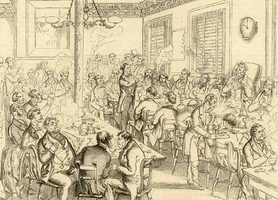
Early entertainments recorded at Penny's Folly include the antics of Mr Zucker's performing horse. (fn. 105) As the Belvidere, the establishment became more than locally well–known for two activities besides drinking: rackets, played in a court in the garden, and Saturday-night discussion meetings, where political subjects were aired, held with free admission in an upstairs room. The clientele in the eighteenth and nineteenth centuries is said to have included some notable figures, particularly writers and actors, among them Hazlitt, a keen rackets watcher; Grimaldi the clown; the illustrator Isaac Robert Cruikshank; and George III's favourite actor, the comedian John Quick. The British Horological Institute was founded here in 1858. (fn. 106) G. A. Sala distinguished the Belvidere clubroom from the general run of political meeting rooms by its 'eminently respectable aspect', and he contrasted the radical views of the speakers with their tamely conformist appearance. The convivial scene was illustrated in his Twice Round the Clock in 1859 (Ill. 450). (fn. 107)
A rackets court was built at the Belvidere in 1820; before that the game had been played 'in much more primitive style', together with Dutch quoits and skittles. The court, which attracted some top players, was surrounded at a safe distance on three sides with open refreshment boxes for spectators (Ill. 449). There was also, by 1856, an American bowling alley and, inside the pub, 'one of the largest and finest' billiard saloons in London, and a private billiard room too. (fn. 108)
449. Gardens and rackets court at the Belvidere, c. 1828
Though sports at the Belvidere were flourishing at this time, the available space had earlier been greatly curtailed with the building of Athol Place along the front of the garden. The reduced garden did not long survive the rebuilding of the pub in the 1870s. In 1880 the lessee put forward proposals for building over it a substantial block of model dwellings, to cost £10,000 and offer accommodation for sixty families. T. H. Watson, the Penton Estate surveyor, was enthusiastic but the scheme fell through. (fn. 109) The garden was subsequently occupied by a piano factory, and later the Gloy glue works; another industrial activity here, in the late nineteenth century, was the manufacture of extractor fans by the Blackman Air Propeller Co. (fn. 110) It now forms part of the Public Carriage Office site in Penton Street.
Nos 100–154 Pentonville Road
450. Saturday-night discussion meeting at the Belvidere, 1858
The row of eight shops immediately west of the Belvidere at Nos 100–114 was built in about 1839 as Athol Place (see Ill. 451), and occupies part of the old tea-garden. Early occupants included an optician, a bookbinder, a furrier and a window-blind maker, a tobacconist and a bootmaker. A ninth house, No. 98 (formerly No. 1 Athol Place), originally a pastrycook's, was incorporated into the Belvidere in the 1860s. (fn. 111) The developer of Athol Place is not known, but the name's Scottish derivation suggests that the Belvidere's landlord at the time, Hugh McDiarmid, might have been involved. (fn. 112)
451. Nos 100–120 Pentonville Road (right to left), in 2007; former Athol Place, now Nos 100–114, far right
452, 453. Nos 116–118 Pentonville Road, 2007. Courtyard (right), with No. 116a (a house of the 1780s) to the rear, and former workshop in front; (left) interior of workshop, and manager's office
The houses typically comprised a ground-floor shop and parlour with living-rooms or stores above, and a small back yard. The style of the houses at the east end of the row—faced in stucco with moulded window surrounds— probably dates from the reconstruction of the upper floor fronts in the early 1880s. (fn. 113)
Though externally similar, the four adjoining shops at Nos 114a–118 date from 30 years later (Ill. 451), having been erected in front of the two old houses at the east end of the former King's Row in 1869 by an Islington builder, John Sharman. (fn. 114) Early occupants included a jeweller, an artificial florist and a haberdasher.
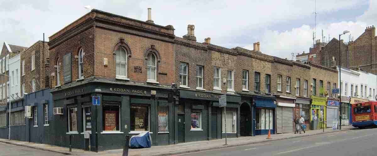
Today most of Sharman's shops form part of an organic agglomeration of buildings at Nos 116–120 (and continuing round the corner at 1–2½ Hermes Street)—old houses, mid-Victorian shops, small warehouses and later additions, currently occupied by the publishers Kogan Page Ltd and a rare survival locally of such accretive premises.
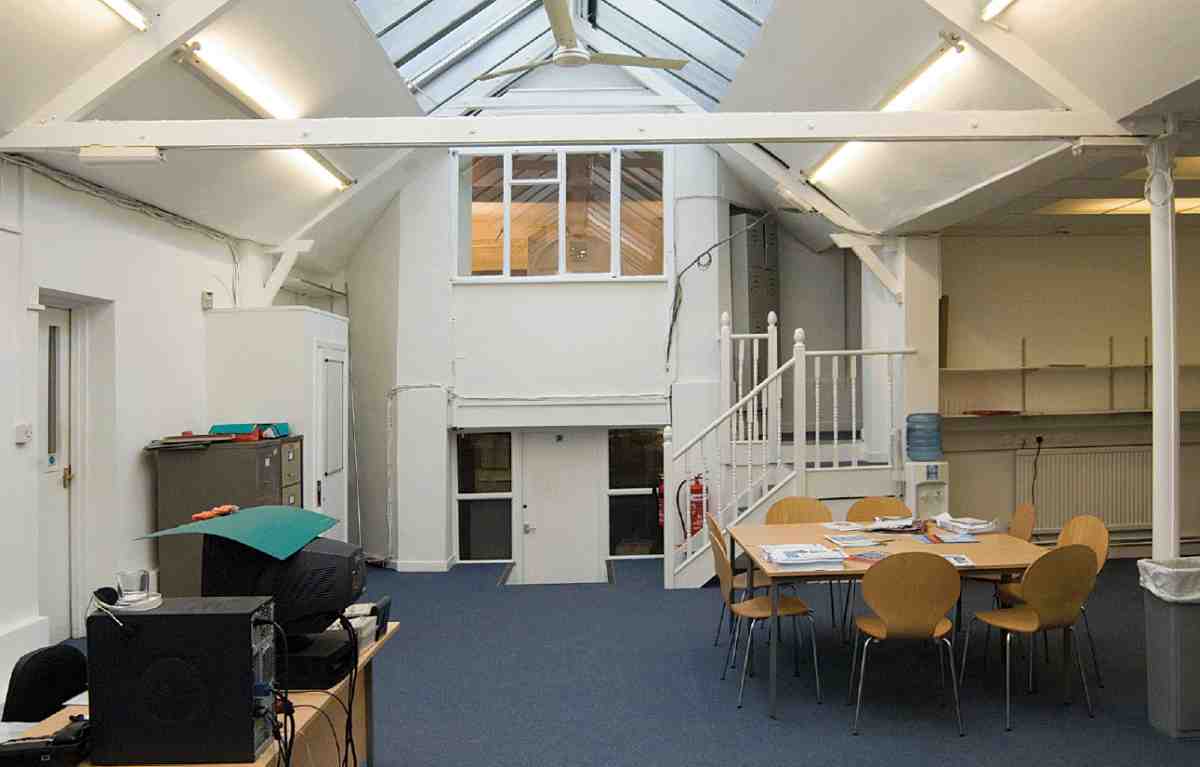
Today the oldest fabric is a bay-fronted late-1780s house at the rear of the site, until recently numbered 116A (Ill. 453). This was one of the former gentleman's residences of King's Row, set well back from the later building line, now much rebuilt and altered but still with a few original features. Until recently another old house stood further forward immediately to the west (No. 118A), but this has been demolished and rebuilt in facsimile. Both houses may have been designed by the architect Aaron Hurst, the first lessee. (fn. 115)
In 1872 Sharman built a workshop for the artificialflower makers in the yard, directly in front of the old house, mostly of one storey and glass-roofed but with a narrow first-floor extension along one side. The baywindowed rooms of the house, overlooking the workshop floor, made ideal managers' offices (Ill. 452). (fn. 116) These buildings were later used by a piano manufacturer, and the London Sewing Machine Co. Ltd, and in about 1899 were taken over by the Salvation Army as barracks and a mission hall, which they remained until after the war, reverting then to commercial use. (fn. 117)
No. 120 was built as a beerhouse in 1851 on the garden of No. 1 Hermes Street, and was called the Welsh Bull by 1866. It was originally of one storey only, the first floor being added in 1881 for the brewers Truman, Hanbury & Buxton (Ill. 451). The ground floor was remodelled in 1893 by the architect W. G. Shoebridge. In this typical late Victorian refitting the old bar parlour and tap-room disappeared and a large bar counter was installed, with subdivisions to make four bars of varying size and a jugand-bottle counter. The main entrance lobby, opening on to the public bars, was on the corner, with a faiencecovered iron column at the angle. The beerhouse closed in 1911, a renewal of the licence having been refused. It was subsequently occupied by a firm making tin boxes. (fn. 118)
On the west corner with Cynthia Street, the two knocked-about old houses at Nos 130–134, now minus their single-storey shop-additions, were formerly part of the extensive cocoa factory of Dunn & Hewett. Daniel Dunn, maker of soluble chocolate and coffee essence, one of the first commercial occupants in King's Row, was based at No. 9 (later No. 136 Pentonville Road) from about 1833. In the 1850s he went into partnership with Charles Hewett, and in the 1870s the firm, who described themselves as the inventors of soluble chocolate and cocoa, took over No. 138 as well. The premises were enlarged and partially rebuilt in the 1880s and 90s, when an extension at Nos 6–10 Cynthia Street (see pages 421–2) was built, to provide more space for chocolate-making, packing and storage. (fn. 119) By about 1907 there was also a tea-room at No. 140 for the girls working in the factory, and apparently for members of the public too. (fn. 120) Dunn & Hewett's factory closed about 1930, and was subsequently sub-divided and let to various enterprises, including firms making Christmas crackers and radios. (fn. 121)
The red-brick factory at the corner with Rodney Street, at Nos 152–154, was built in 1936 for the Ealing Radiator Co. Ltd (later E. R. Engineering), which made car radiators (Ill. 454). It was designed by W. E. Gladstone Hull, architect, of Wembley Park. (fn. 122) Originally the rear buildings and the return along Rodney Street were only of one storey. A first floor extension in matching style was added in 1952 to designs by John K. Greed of Richmond. Greed also designed the low metal-framed building alongside at Nos 136–150 (now a service garage), erected in 1962–3 as a warehouse extension for Macready's Metal Co. Ltd (based across the road at Nos 131–135), who had recently taken over both sites. (fn. 123)
454. Nos 152–154 Pentonville Road. Car-radiator factory of 1936; W. E. Gladstone Hull, architect
Rodney Street to Calshot Street
The two oblong blocks between Rodney Street and Calshot (originally Southampton) Street, extending north to the Penton estate boundary, were the subjects of building agreements in 1786 and 1789 respectively between Henry Penton and the brothers Alexander and John Cumming. Alexander's take was mostly built up with terrace-houses, some of the largest in Pentonville, but he gave up the New Road frontage for the building of the long-awaited Pentonville chapel of ease, later St James's, Pentonville. John's ground, too, was built up with terracehouses, but he reserved the prime site for his own detached residence, Cumming House. Facing the New Road, this stood in a large garden extending to Collier Street, and was flanked at a little distance by short terraces of goodclass houses, the ensemble taking the name Cumming Place. (fn. 124)
Structurally, little of the original development survives along Pentonville Road, nothing whatsoever beyond. But the pattern set down along the main road frontage in the 1780s and 90s persists: almost unchanged on the east side of Cumming Street—where the church, destroyed in the 1980s after a tortured history, was rebuilt in loose facsimile as offices—and still recognizably on the west, where a few old houses, with some rebuilding, survive behind later shops (Nos 176–182).
The front gardens or forecourts of Cumming Place disappeared by degrees. By the 1870s a few had been built over, including that on the corner of Cumming Street, where there was a single-storey extension used as a public house, the King George IV. Similar extensions for shop use were to cover all the terrace-house gardens before many years were past; at the four houses adjoining the King George IV, these shops were independent structures, alleys giving access to the fronts of the houses behind. Cumming House, much extended and no longer detached, was in institutional use. Within a few years it had been demolished for a large development of shops and model dwellings on either side of a new street, Affleck Street, a fragment of which development survives in the form of Nos 166–174 Pentonville Road. Affleck Street was reduced to a stump by the creation of the Priors Estate in the 1970s (see page 431). East of Affleck Street there remains a degraded row of single-storey shops, the old houses behind now long gone. On the corner of Cumming Street, at No. 156, the King George IV survives in the form of a ground-floor bar in a new terracotta- and aluminium-faced apartment block designed by Alison Brooks Architects (ABA) for Woodlands Estates, completed in 2005–6. (fn. 125)
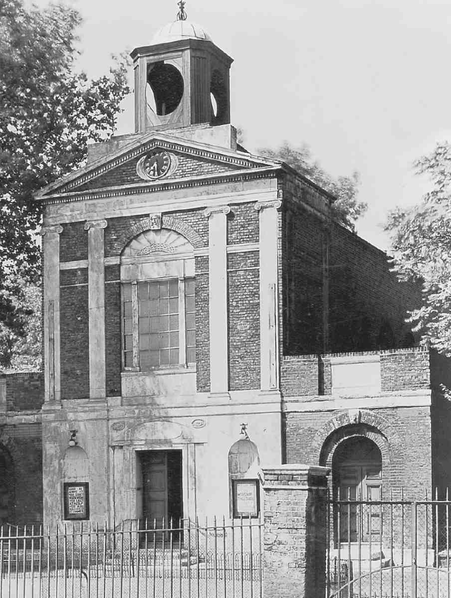
St James's, Pentonville (demolished)
Pentonville Chapel, later St James's Church, was the centrepiece of the suburb of Pentonville. Built in 1787–8, it became a familiar if isolated landmark on Pentonville Road, conspicuous in the foreground of John O'Connor's view of St Pancras (Ill. 429). Towards the end of its life, Ian Nairn enjoyed the 'splendid, racy rhythm' of its main window, and found its yellow bricks 'among the mellowest and duskiest in London'. (fn. 126) Ecclesiastically the chapel enjoyed little fortune. It was declared redundant in 1978, damaged by fire, and pulled down in 1984. Its replacement, Grimaldi Park House, pastiches the chapel front but contains no shred of the old fabric.
New churches or chapels were viewed as crucial components in major Georgian schemes of urban development, and Pentonville's promoters did their best to provide one. In 1777 Henry Penton persuaded the Clerkenwell Commissioners for Paving to allow in their local improvements Bill provision for a chapel of ease to serve the residents of his estate. A site 'near Penton Street' was proposed, and preparations for building followed. The venture was scuppered by the vicar of Clerkenwell, William Sellon, who was required to approve the scheme but declined to underwrite the minister's salary. Since neither the commissioners nor the churchwardens were prepared to give the bond that Sellon demanded, the matter dropped. (fn. 127)
Ten years later, with the building-up of Pentonville advanced, work began on a chapel funded by subscribers, fronting what was then the New Road. The new initiative was doubtless in large part due to Alexander Cumming, the Scottish-born watchmaker and inventor who was a prime mover in Pentonville's early development, since the chapel was erected on the front of the block of land taken by Cumming from Penton under his building agreement of January 1786 (see above). (fn. 128) This was almost certainly not the site originally intended, which seems to have been in Chapel Market (then Chapel Street). The first intention appears to have been to flank the chapel with 'handsome houses, as wings to the edifice'. (fn. 129) According to James Malcolm there were to have been just two houses, which would have been on a large scale, given the size of the plots. (fn. 130) No such flanking houses were erected, and the side elevations of the chapel as built in 1787–8 were regularly fenestrated as for an open site. Directly behind the chapel, a narrow graveyard extended back between the gardens in Rodney and Cumming Streets as far as Collier Street, where two 'commodious' gate lodges made up a residence for the chapel clerk (Ill. 531). Extra land on either side of this strip was leased to Cumming at the end of 1788, allowing for the graveyard to be enlarged. On New Year's Day 1789 he was granted a perpetually renewable 21-year lease of the chapel and enhanced graveyard, along with two fellow trustees, Penton's steward Thomas Collier, and Abraham Rhodes, clerk to the Vestry and the Paving Board. (fn. 131) This unusual leasehold status continued for most of the chapel's ecclesiastical life.
It was evidently intended that the chapel should conform to the Church of England. During its construction, its acquisition by the parish was discussed at a meeting between the subscribers and the Commissioners of Paving. Once again Sellon appears to have been obstructive, with the result that it opened as technically a dissenting chapel, with attendance restricted to paying seat-holders. The first minister, Joel Abraham Knight, had been a preacher at the Countess of Huntingdon's Spa Fields Chapel, another foundation that brushed with Sellon (see page 57). (fn. 132) In 1790, however, a Bill was successfully brought forward which inserted an obligation to purchase Pentonville Chapel into permission to raise additional funds for rebuilding the parish church. (fn. 133) The renewable lease having thus been acquired by the parish, the chapel and burying ground were consecrated on 8 June 1791. (fn. 134)
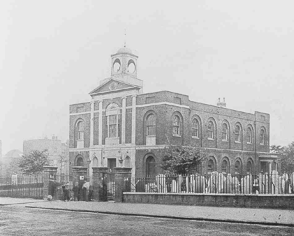
455. St James's Church, Pentonville. View from south-east, c.1900
Pentonville Chapel was the work of a young architect, Aaron Henry Hurst, also one of the subscribers and a participant in designing and developing houses hereabouts. Set back from the road behind gates and a semicircular drive, in plan and outline it conformed to the typical Georgian preaching-box, brick-built and squarish, with round-arched windows and doorways echoed by relieving arches (Ill. 455). Externally, ornamentation was confined to the Pentonville Road front, where a flat, pedimented centrepiece in Adamesque taste, made up of Portland stone with Coade stone ornaments, was surmounted by an open-sided timber cupola, later described as a 'baby belfry'. (fn. 135) A clock obtruded in the pediment's centre, leaving the cupola above hollow-looking, though it contained a bell. There were subsidiary porches at the north end of each side.

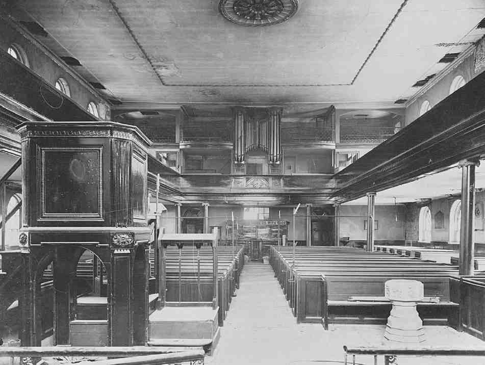
456, 457. St James's Church, Pentonville. Interior in 1925, (left) looking north to chancel and (right) looking south (to liturgical west end)
The interior was plain, with a flat plaster ceiling and galleries carried on Ionic pillars (Ills 456, 457). A semicircular apse at the north end formed a sanctuary, framed by an arch and Ionic pilasters and flanked by vestries. It contained an altar table surmounted by inscriptions of the Lord's Prayer, the Decalogue and the Creed, and over them a painting by John Frearson, an amateur who specialized in scriptural scenes, showing Christ raising Jairus's daughter ('in West's feeble manner' according to Walford), donated by one of the subscribers, Samuel Walker, at the time of the chapel's opening. In front of the iron altar-rails stood a square pulpit, later joined by a Coade stone font in the form of a pedestal and vase decorated with fruit and flowers. Both the font and the altar painting seem to have survived until the church's closure, though the painting had been removed to the south aisle. (fn. 136) Beneath the chapel were well-ventilated vaults, where Hurst was interred on his premature death in 1799, as was Henry Penton in 1812. Notable early interments in the burial ground included R. P. Bonington, the landscape painter (1827, later removed to Kensal Green), the younger Charles Dibdin, theatre-manager and writer (1833), and Joseph Grimaldi the clown (1838). (fn. a)
Pentonville Chapel cannot have been well built. Hurst found dry rot in the vaults in 1797, and there was recurrent trouble with the roof. After Hurst's death, the maintenance of the chapel fell largely to the supervision of James Carr, the architect of the parish church, to whose designs extra galleries for schoolchildren were added to the chapel in 1811. He was succeeded as surveyor to the chapel by William Lovell in 1816. Gas was laid on in 1821. (fn. 138) The later nineteenth-century history of the chapel was enlivened by the antics of the Rev. A. L. Courtenay, who procured a definite district for it in 1854, when the name St James's, Pentonville—current at least thirty years before—became official. Courtenay decamped to his new foundation of Christ Church (later St Silas), Penton Street, in part because he disliked St James's, but then returned (page 379). In 1874 The Builder noted that the church's history 'has been for many years one of incessant litigation and disagreement'. (fn. 139) That year also saw an abortive proposal to install a mortuary for Clerkenwell either in the vaults or in the burial ground. (fn. 140) Burials had ceased in 1853, and the burial ground was neglected for many years. By the 1890s it was, allegedly, so frequented by prostitutes that 'some sixty or seventy' of them might be there by day or night, and in 1896–7 it was taken over by the Metropolitan Public Gardens Association and laid out as a garden, with the tombstones set against the church walls. (fn. 141)
Intermittent anxieties about the structure, perhaps due to the downhill slippage of the clay subsoil and the decay of the original oak and fir foundation raft, came to a head in 1919, when in view of its overhanging north and west walls a dangerous structure notice was served. A flurry of reports followed. The incumbent, Robert Foulkes, appealed for outside funds, stating that 'there is hardly any church feeling or sympathy for the church in the parish'. (fn. 142) Caroe and Passmore, the architects on behalf of the main grantors, the London Diocesan Fund, suggested putting steel tie-rods across the building at gallery level. That was opposed by the diocesan surveyor, C. Wontner Smith, who thought the construction of the Northern Line beneath might be partly to blame, and more forcibly by Foulkes, who in 1920–1 persistently tried to prevent Dove Brothers from proceeding with the work, stating 'I shall never allow anyone to put the rods through the church'. (fn. 143) Nevertheless Foulkes was keen to have the church restored, publishing pamphlets to warn the people of Clerkenwell that if it were demolished the endowment which Henry Penton had dedicated to the chapel might revert to his heirs. Some repairs were eventually carried out, but St James's continued to deteriorate. Following the partial collapse of the ceiling it was temporarily shut in 1925, services continuing in the church hall in Collier Street. Formal closure followed in 1928.
458. St James's Church, Pentonville, in 1963
St James's would almost certainly have been demolished and its benefice absorbed into neighbouring districts but for the intervention of the Rev. Percy Warrington, vicar of Monkton Combe near Bath. In 1929 Warrington offered to pay towards the repairs if the patronage were vested in his name. He was rebuffed, but in 1931 induced an Oxford architect, R. Fielding Dodd, to study the problem. The following year he employed another architect, T. Murray Ashford of Birmingham. It was on a technical programme agreed with Ashford by Caroe and Passmore, acting for the Ecclesiastical Commissioners, that St James's was recast in 1932–3 and reopened. The main contractors for this work were Coles Brothers of Peasedown St John near Bath, who came close to liquidation, since costs doubled and it turned out that Warrington's finances were muddled; much of the remedial work had to be paid for out of grants. For their part, Caroe and Passmore found the Coles' work 'generally unsatisfactory' and 'not dealt with in an economical manner'. (fn. 144)
Ashford's drastic policy with St James's involved the entire demolition of the side walls from gallery level upwards and the nave's reduction to a narrow vessel sustained by hidden steelwork. The church thus lost its side galleries and assumed the section of a Gothic building with low aisles, to the detriment of its dignity (Ill. 458). Ashford returned the cornice and pilasters of the front pediment by one bay round the sides, 'thus overcoming the weakness of the old design', he claimed. (fn. 145) Fittings were installed into the recast church by Jolly & Son of Bath.
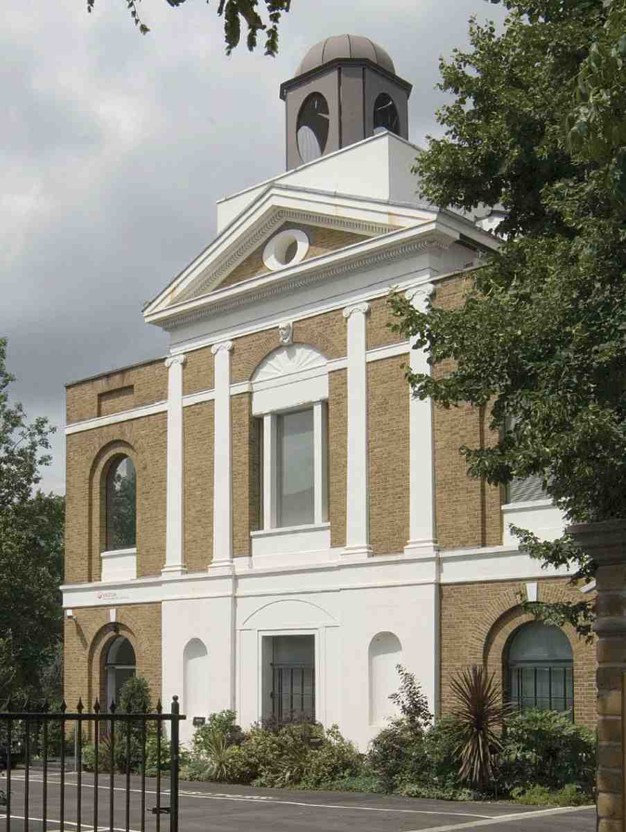
459. Grimaldi Park House, Pentonville Road, in 2007. Allies & Morrison, architects, 1990
Still neither the parochial nor the structural problems of the building were solved. Following at least two further bouts of reinforcement, the church was described in 1977 as 'a constant source of anxiety and expense during the whole of the twentieth century'. (fn. 146) Next year St James's was again closed. This time there was to be no reprieve. Various proposals were entertained for reusing portions of the church, but its structural difficulties and the fact that since the 1930s it had become 'something of an architectural fraud' told against it. (fn. 147) The fulminations of 'Piloti' in Private Eye against the 'disgraceful and disgusting condition' of a fabric desecrated by fires and squatters were of no avail, and in 1984 it was demolished. (fn. 148)
By that time the last act for St James's had been prepared. In 1983 Islington Council recommended a plan originating with Cornerstone Ltd and endorsed by the Church Commissioners 'for a complete reconstruction of the building to its original 1787 external design for offices'—in other words, a replica. In the event the site was sold on. Not until 1990 did the 'strange and puzzling new building' known as Grimaldi Park House arise on the site to Allies & Morrison's designs. (fn. 149) Working with Kyle Stewart Special Works, these reputable architects took some care with the rebuilding on behalf of Scott Howard Furniture Ltd, recreating the pre-1932 façade in simplified style and providing offices behind and to the sides in the best Ibstock bricks (Ill. 459). Over the upper-floor window on the front is a keystone representing Grimaldi, while in a post-modern touch abrupt traces of stone cornice bands appear on the flanks.
Most of the burial ground passed into the ownership of Islington Council in 1968, the open space around the church following on later. The whole block bounded by Pentonville Road, Cumming Street, Collier Street and Rodney Street having been designated as open space after the Second World War, the remaining houses on the east side of Cumming Street and west side of Rodney Street were demolished. The resulting open ground behind Grimaldi Park House now consists of an indecisively landscaped park, known at first as St James Garden, later as Joseph Grimaldi Park. A playground area to the west is divided from gardens on the east by the single patched survivor of the two north—south walls which originally separated the graveyard on both sides from the back gardens of houses on the flanking streets. Largely illegible gravestones line some of its walls and fences, Grimaldi alone having a railed place of honour by the north-east corner of Grimaldi Park House, though this was not the original place of his burial.
London Female Penitentiary (demolished)
Not long after John Cumming's death in 1796, Cumming House became a Roman Catholic girls' seminary. This institution originated with a community of nuns who came to England in 1792 from the Abbaye des Prés near Douai. After staying briefly in Hammersmith, at what later became Sacred Heart Convent, they moved to Cumming House, where a day and boarding school was set up under the direction of Madame Florence Vittu. This closed in 1806, and in the following year the house took on a new institutional guise, as the London Female Penitentiary, or Female Penitentiary Asylum. (fn. 150)
This charitable refuge and reformatory for prostitutes was based at Cumming House (later numbered 166 Pentonville Road) from soon after its foundation in 1807 until 1884, when it moved to Stoke Newington. It was the earlier and larger of two such reformatories in nineteenth-century Pentonville, the other being the Home for Penitent Females in White Lion Street, opened in the 1840s (see page 386). During the institution's occupation the original house was greatly enlarged, enabling a hundred women to undergo its regime of 'mild discipline, useful instruction, and the ordinances of religion'. (fn. 151) Although not the first establishment of the kind, this was one of the most important and well-known, attracting the patronage of the Prince Regent and the active support of leading philanthropists including William Wilberforce, who became its president in 1823. (fn. 152)
The Penitentiary grew out of a scheme outlined by an anonymous contributor to the Evangelical Magazine of December 1804. This was to help prostitutes who wanted to give up their way of life by opening refuges in quiet out-of-town locations, and was intended to be on 'a more popular and general plan' than existing institutions (such as the Magdalen Hospital in Blackfriars Road). Women and girls would apply directly for admission in response to advertisements, and their supervision would be largely in the hands of respectable London ladies. A feature probably inspired by existing practice at the Magdalen was that they would be segregated according to social background, so that they could receive appropriate training for work. (fn. 153)
After further airing of the subject in the magazine's pages, a general meeting was held at the New London Tavern in the City on 1 January 1807, when the 'London Female Penitentiary' was inaugurated. Behind the new venture were a number of prominent evangelicals variously involved with the London Missionary Society, the Religious Tract Society, and the British and Foreign Bible Society, including George Burder, editor of the Evangelical Magazine, and Adam Clarke, the Wesleyan divine. There was also a strong City element. Subsequently, two distinguished medical officers were appointed: George Pinckard, founder of the Bloomsbury Dispensary, and William Blair, surgeon to the Bloomsbury Dispensary, a Methodist and a supporter of the British and Foreign Bible Society. (fn. 154)
Before long a number of 'chiefly very young persons' were being looked after by the society, and after much searching for a suitable home 'in an airy and healthy situation' Cumming House was found, and a long rent-free lease purchased. Following alterations, including the construction of an attic dormitory, the Penitentiary opened in 1808, on the first anniversary of the inaugural meeting. (fn. 155)
By June 1814 the premises were open to public inspection one day a week, and in the course of the following year received 2,861 visitors. (fn. 156) But although considerable support was forthcoming, it never reached a sufficient level for the large-scale extension of the buildings originally proposed, and for most of its life the Penitentiary was not occupied to full capacity.
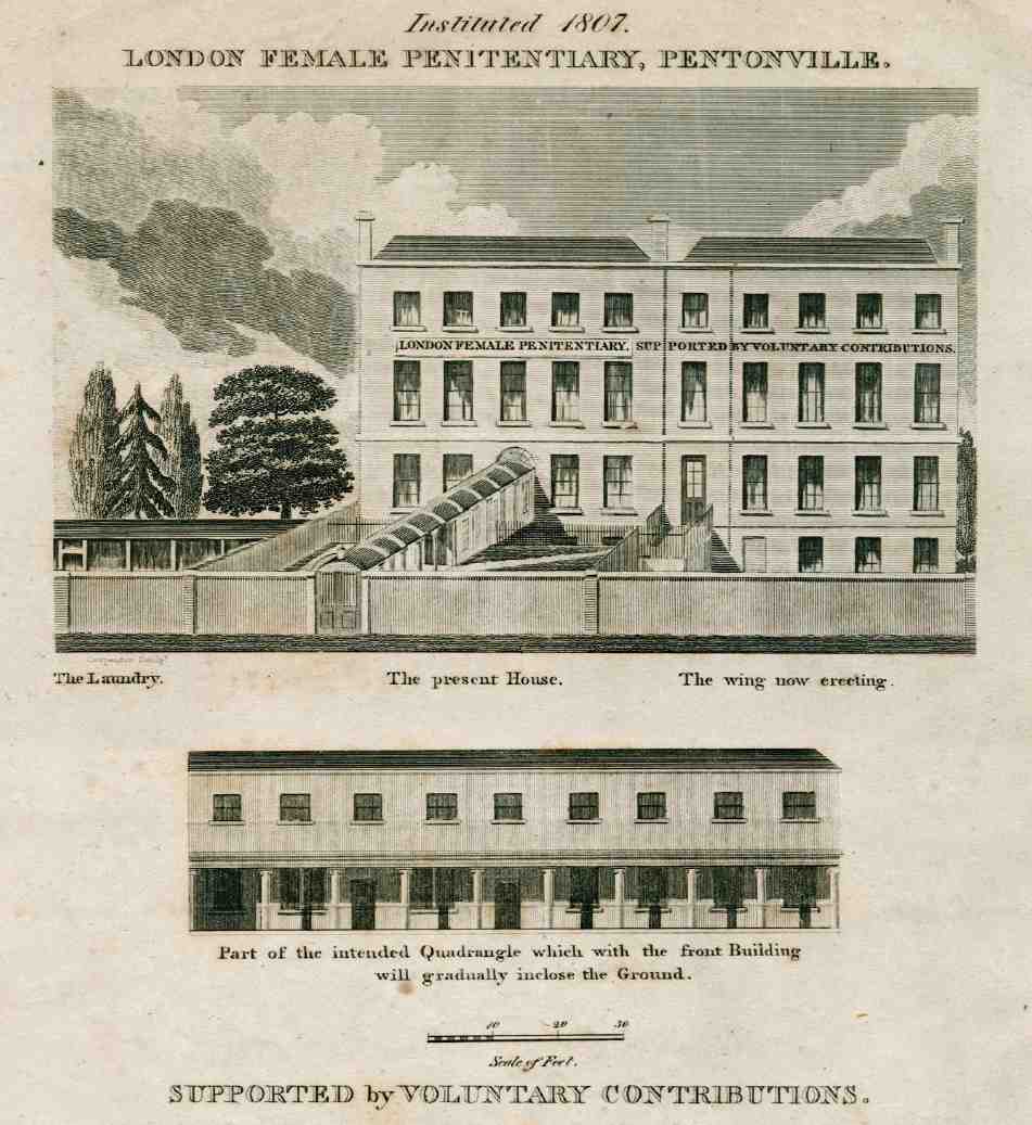
460. London Female Penitentiary, No. 166 Pentonville Road. Main elevation c. 1811 (above) and part of the intended quadrangle. Demolished
From the start, women took a major role in its running. Management was divided between two committees: one, all male, conducted external business, while internal matters were under the control of a ladies' committee. Perhaps the most important single figure was the Matron, at first unsalaried. Accommodation was divided into a Temporary Ward for emergency admissions, a Probationary Ward, where new inmates spent two months, a ward for full admission (where inmates spent up two years), and a 'Ward for Diseased Objects'. (fn. 157) In the early years, until the premises were enlarged, a house in John (now Risinghill) Street was rented for an infirmary to prevent the spread of infection. (fn. 158)
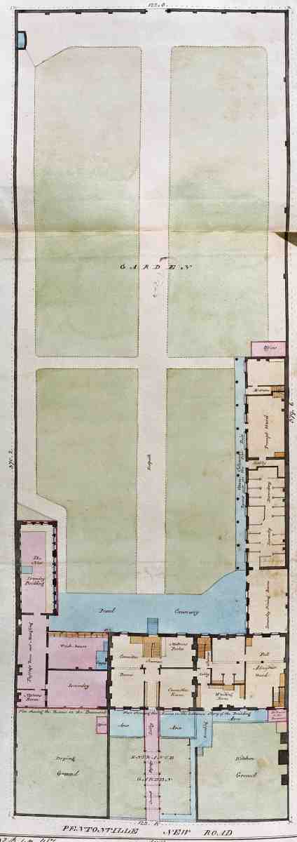
461. London Female Penitentiary, No. 166 Pentonville Road. Ground plan in 1832. Demolished
The penitents spent their days engaged in manual labour, chiefly washing, mangling and ironing, needlework, or making shoes and other items, for themselves and their fellows as well as commercially: they were originally allowed a third of the proceeds of their labour. Their time seems to have been served entirely within the high walls of the Penitentiary grounds, for the premises provided not only for work but for worship and outdoor exercise. During their stay, efforts were made to bring about reconciliation with friends and families. If they were still at the Penitentiary after two years, outside situations were found. Rewards were offered to encourage them to remain in these posts: a guinea after one year, two guineas after two. (fn. 159) Especially in its early years, the Penitentiary was mainly the refuge of teenage girls. 'Indolence, bad female companions, frequentings of fairs, the theatre, dances, etc' were cited as among the causes of their becoming involved in prostitution; some were victims of abduction and violence. (fn. 160)
Though the inmates themselves were kept 'very properly secluded', (fn. 161) the institution proclaimed its name boldly on a facia over the first-floor windows. The plain appearance of John Cumming's house chimed well with its sober purposes, and subsequent additions were emphatically 'erected in the plainest manner possible' (Ill. 460). (fn. 162) In 1811–12 the house was more than doubled in size by the building of an east wing and behind it a twostorey extension with a colonnade along the ground floor. The idea seems to have been for a matching west wing as well (thus filling up the entire frontage of the site) and for the extension to continue right round the garden, making a large quadrangle. Finances never allowed this. The west wing, comprising a laundry, rose no higher than basement level, though some years later an additional laundry room was built at its rear (Ill. 461).
The Penitentiary site: Nos 166–174 and Affleck Street
Close to the expiry of the lease, the Penitentiary society decided that it could not afford a renewal and in 1884 moved to No. 161 High Street, Stoke Newington, where it continued to exist until c. 1939, latterly as the London Female Guardian Society. Redevelopment plans put forward in 1880 to the Penton Estate by a local businessman, Alfred Attneave, were at last implemented. Attneave, a clothier at Nos 190–194 Pentonville Road, pulled down the Penitentiary and laid out a new north—south street on the site in 1884–5, with shops on the main road frontage occupying the forecourts of the old buildings. The new street, following the naval precedent of Rodney Street, was named after Admiral Sir Edmund Affleck, who took part in Rodney's relief of Gibraltar. (fn. 163)
Attneave's architects were initially Carritt & Monier Williams, who seem to have been responsible for the shops on Pentonville Road, and perhaps the first few houses at the southern end of Affleck Street, built in 1886. (fn. 164) Although Affleck Street was demolished by 1970 for the building of the Priors Estate and the roadway itself largely obliterated, the Pentonville Road shops (now Nos 166–174) are still standing (Ill. 463). They are tall buildings of stock brick with red-brick banding and dressings, and stone or cement cornices. Most of the houses in the new street, however, built during 1888–90, were the work of William Gillbee Scott (Ill. 462). (fn. 165)
No. 166D (now 174) Pentonville Road was first occupied by the Howard Institute & Home for Young Women, formerly at No. 189. This third institution for females on the site moved a few years later to nearby Cynthia Street. (fn. 166)
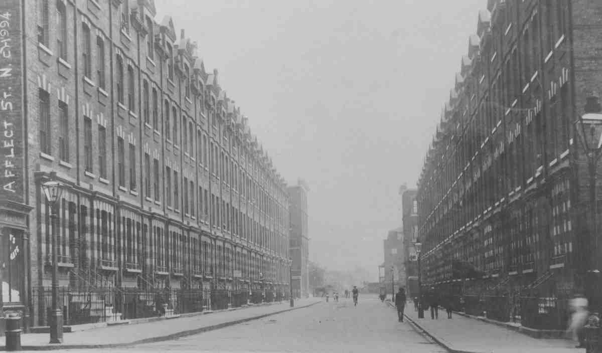
462. Affleck Street, looking south to Pentonville Road, c. 1900. Demolished
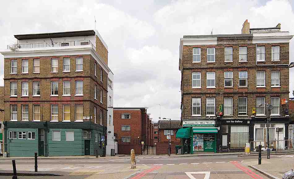
463. Nos 166–170 and 172–174 Pentonville Road (right to left) in 2007
Calshot Street to Northdown Street
The ground here, part of Great Grace Field, was built up in the 1780s as Pleasant Row, comprising two terraces divided by Winchester (now Killick) Street and another four houses further west to Providence Row (see Ill. 528, page 406). On the sites now occupied by Nos 188–244 Pentonville Road, these houses were developed mainly by Samuel Coney, victualler, and the builder Joshua Hodgkinson, both of St Pancras. (fn. 167)
Early residents included at least three 'gentlemen'. (fn. 168) George Medhurst (d. 1827), the engineer and railway inventor, began his working life in Pleasant Row as a clockmaker, but moved to Battle Bridge and changed tack having been badly affected by the 1797 duty on clocks. (fn. 169) The 1830s and 40s saw an increase in trade occupation. (fn. 170) At Nos 7 and 8 (later Nos 224 and 226 Pentonville Road), was John Edney's boarding and day school, an enlightened establishment where the emphasis was placed on incentive rather than compulsion, and there was no corporal punishment. (fn. 171)
By the 1850s most of the houses were in commercial use, and by the 1870s only a few front gardens had escaped the building of shop-additions (see Ill. 426). All had gone within thirty years. (fn. 172)
A notable manufacturer based here from the 1880s into the early 1900s was T. H. Prosser & Sons, at Nos 198–200, the leading makers of rackets, lawn tennis and athletic equipment. (fn. 173) Established in Pentonville in the 1850s, Prossers supplied universities and schools, and were official makers to Princes Club in Knightsbridge and Queen's Club in West Kensington. They were also the first to make lawn tennis rackets, under the direction of Major Wingfield, inventor of the game. (fn. 174)
Most of the frontage from Calshot Street to Killick Street was redeveloped from the early twentieth century by Lilley & Skinner, the shoe company. Further west, to Northdown Street, a mixture of shops and workshops remained until the Second World War, when many were destroyed by bombing. At Nos 212–218 was the 'Warrior Works' of Nuckey Scott & Co., makers of taps and dies, a jumble of small shops and single-story zinc-roofed workshops built on to old houses. (fn. 175) No. 234 was the Cosy Corner Picture Playhouse. This 270-seat cinema opened in 1911, having been fitted out to designs by Lovegrove & Papworth, architects. It closed in 1926. (fn. 176)
The large site at the Northdown Street corner, devastated by a V1 flying bomb, was used as King's Cross Coach Station in the 1950s, with a temporary single-storey building. (fn. 177) Proposals for redevelopment with offices were refused in 1962, and in 1967–8 the present seven-storey building, No. 210, was erected as warehousing and showrooms by Brixton Estates Ltd, to designs by R. W. Kenzie. Largely glass-fronted, with red-brick 'pilasters', it was set back at the LCC's behest to follow the building line of Lilley & Skinner's warehouse to the east, allowing a service road in front. (fn. 178) Latterly known as Webb House, it was occupied throughout the 1970s and 80s as a BUPA medical centre and a NatWest training centre. (fn. 179) It has been vacant since 2002. (fn. 180)
Lilley & Skinner's headquarters (demolished)
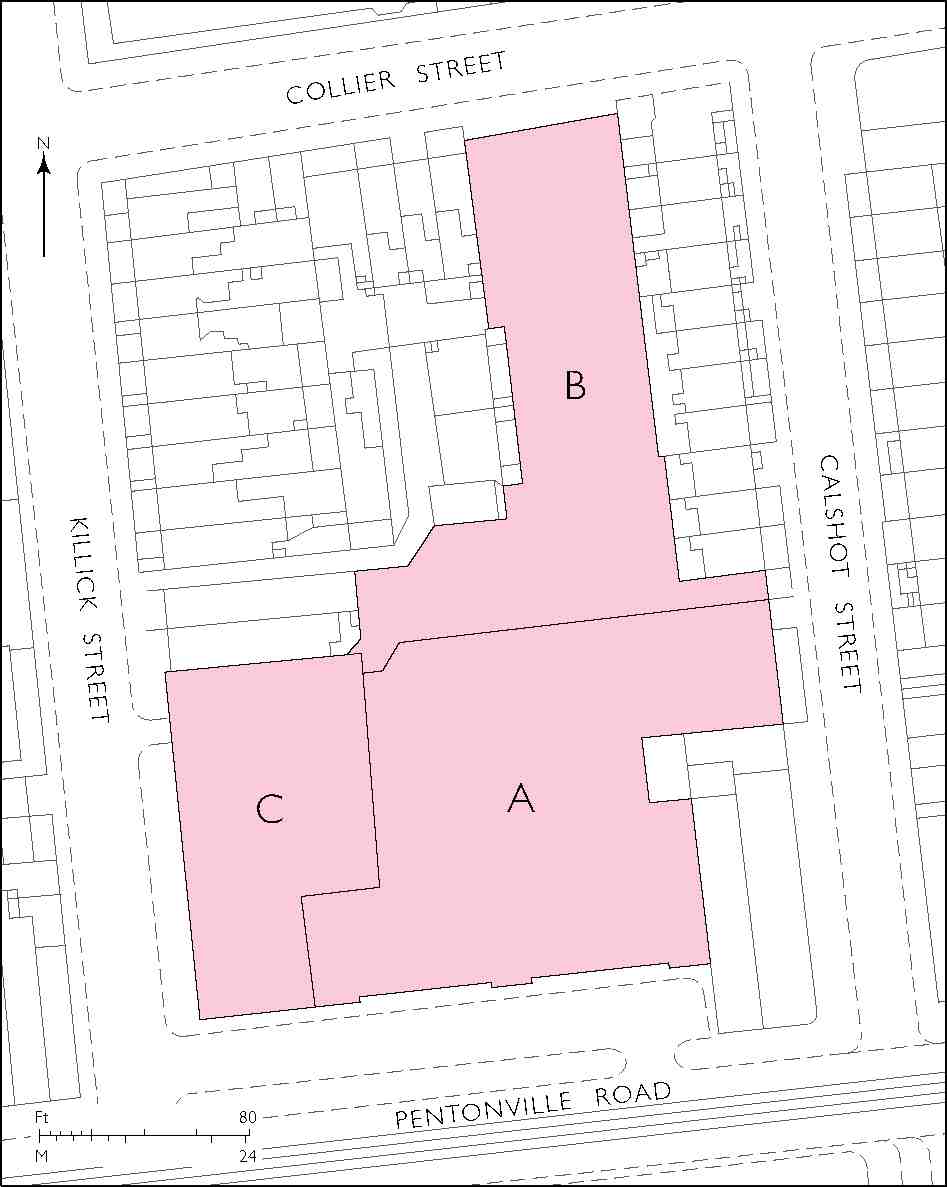
464. Lilley & Skinner's warehouses, Pentonville Road, block plan in 1938. (A) Arthur Sykes, architect, 1911–12; (B) Gordon Jeeves, architect, c. 1926–7; (C) Sir Owen Williams, engineer-architect, 1935–6. Demolished
For sixty years the block bounded by Pentonville Road, Killick, Collier and Calshot Streets was associated with the shoe manufacturers and retailers Lilley & Skinner. A portion of their buildings, a warehouse erected to the designs of the engineer-architect Sir Owen Williams in 1935–6, was the most striking of the twentieth-century industrial premises along Pentonville Road. It supplemented earlier buildings for the firm, started in 1911.
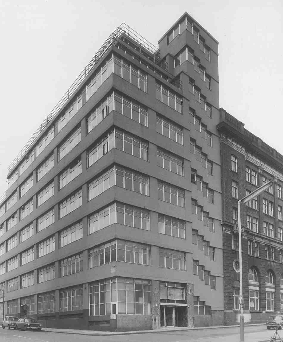
465. Lilley & Skinner's warehouses in 1972. Addition by Sir Owen Williams, engineer-architect, 1935–6. Left, flank towards Killick Street. Right, part of main block towards Pentonville Road, Arthur Sykes, architect, 1911–12. Demolished
Thomas Lilley started his shoe-making business in the Borough in 1835, diversifying thereafter into large-scale manufacture, distribution and retailing. Under his son, the second Thomas Lilley, the firm became Lilley & Skinner and expanded further. (fn. 181) Towards the end of the nineteenth century it was based at Paddington Green and seeking a new headquarters for storage and administration close to the railways, which brought shoes to London from its Northamptonshire factories. To that end, in about 1898 it acquired the reversion of most of the block in Pentonville Road between the present Killick (then Winchester) Street and Calshot (then Southampton) Street (Ill. 464). There were outstanding leases on the various premises, some with several years to run, but the company hoped to negotiate their surrender. (fn. 182)
The intention was to erect a multi-storey building which would come forward to the line occupied by the existing shops added variously in front of the old houses. This was refused by the London County Council. It took over a decade, and fruitless litigation on Lilley & Skinner's behalf, before a new building line could be fixed for the north side of Pentonville Road. By a compromise in 1909, the firm submitted to a building line only 20 ft in advance of the existing houses. The second Thomas Lilley, then its head, pleaded in vain for further concession from the LCC: 'the compromise hits us heavily and in addition we have to suffer from the result of recent litigation … the result to ourselves is very disastrous, involving the loss of several thousand of pounds, and the delay of many years in carrying out a much needed building scheme for the requirements of our business'. (fn. 183)
A boot and shoe warehouse was finally raised in 1911–12 at Nos 192–200 by Arthur Sykes, an architect experienced in retailing and the designer of additions to Lilley's home at Clacton-on-Sea. Six main storeys in height, it had a classicizing front faced in brick with stone dressings and a balustrade above the cornice (see Ill. 465), and an interior with Hennebique reinforced-concrete floors and columns. The contractors were W. J. Fryer & Co. (fn. 184) Piecemeal additions followed, at first by Sykes, then after 1926 by Gordon Jeeves, the architect also of Lilley & Skinner's shop in Oxford Street. Under Jeeves's aegis a small block was added towards Southampton Street, and a deeper repair workshop reaching back to Collier Street. (fn. 185) A chic display room was also created in the front warehouse. In 1926 the site was reported to contain some three acres of floor space, and yet to seem crowded. (fn. 186) By then the firm evidently intended to take in the whole of the island block between Pentonville Road and Collier Street.
A blunter architecture manifested itself in the penultimate major element of the complex, at Nos 202–210, with a long westward-facing return to Winchester Street. Here, abutting the building of 1911–12, Owen Williams used his trademark concrete idiom to raise a warehouse of seven storeys for storing shoes with three floors of stepped-back offices on top (Ill. 465). It was designed in 1934 and erected by the contractors W. J. Cearns Ltd. in 1935–6. (fn. 187) The building followed the manner of Williams' earlier warehouse at Blackfriars for Sainsbury's, but the prominent Pentonville block stood out more in London's landscape.
The structure was in Williams' flat-slab manner, allowing the windows to go up to ceiling level for the sake of good lighting. The loads of the slabs were carried by edge columns along the perimeter, of square section with deep internal haunches (Ill. 466). These columns raked back on the top floors so as to allow continuous glazing to the offices. Where the slabs were deeper towards the back of the building, the perimeter supports were supplemented at mid-span by massive columns of 5 ft diameter with 15 ft-square mushroom heads, instead of the smaller, more frequent columns of orthodox concrete construction. A large spiral chute whereby shoeboxes could be dispatched to the ground floor added to similar chutes within the earlier buildings.
Externally the elevations were characterized by rows of Crittall steel windows, and plain concrete surfaces 'buffed down with a revolving carborundum wheel and left smooth, but not otherwise treated'. (fn. 188) Vigour was imparted to the short Pentonville Road front by endowing the staircase tower with extra height and expressing the stepping on the outside of the building, an idea repeated from the Sainsburys building. Though the block possessed a modernist's structural candour, C. H. Reilly believed its 'clumsy appearance' had 'little to commend it externally'. (fn. 189)
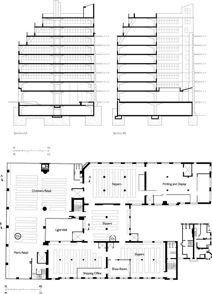
466. Lilley & Skinner's warehouses. (Below) Plan of third floor c. 1950, showing departments. Ch = chute. (Above) Cross-sections through the Owen Williams block. Section points are marked on plan. Demolished
The final major addition recorded to the premises was a building occupying the south side of Collier Street and the east side of Killick Street, thus filling in much of the rest of the island block. Tying in with an LCC slumclearance scheme decreed in July 1939, this was erected in 1939–40 by the builders A. J. Willson & Son to the designs of Donald Hamilton and Kenneth Wakeford. (fn. 190) After the war Lilley & Skinner changed hands and in 1962 were absorbed into the British Shoe Corporation. (fn. 191) All its Pentonville buildings were cleared for the redevelopment of the block after 1972.
No. 200, Nido London (formerly King's Cross House)
Clearance of the former Lilley & Skinner site began in 1972 in preparation for the building of a sixteen-storey office tower-block for (Sir) Stuart Lipton's Sterling Land Co. This was the first large-scale office development on Pentonville Road, and the proposals by Sterling's architects, Chapman Taylor Partners, for a dark, curtain-walled tower—the first of two intended for the site—aroused local opposition. The tower, known as King's Cross House, was constructed in 1973–5 and let to the National Westminster Bank. Debate about its companion, originally to have been three storeys shorter, continued until 1980, when the planners allowed it to go ahead at a similar height—a concession exacted by the bank, which was otherwise not prepared to transfer its training centre (and 700 jobs) there from the City. This second 'black monster' was completed in 1982, the planners having failed to persuade the developers and architects to introduce a contrasting colour of facing material (see Ill. 428, page 337). (fn. 192)
At the rear, council flats were built fronting Calshot Street (at Nos 13–53) in the late 1970s (see page 432). The remainder of the site, on the corner of Collier and Killick Streets, which had been acquired by Islington Council for housing in the early 1970s, was sold in 1982 and eventually developed with more offices in 1990, also by Chapman Taylor. (fn. 193)
Vacant since 2000, the towers were acquired in 2004 by the New York-based Blackstone Group, who proposed a mix of uses for the site—chiefly student accommodation, having identified a growing demand particularly from overseas students. (fn. 194) A scheme by the architects T. P. Bennett was approved in 2006, and since then construction has begun with Allford Hall Monaghan Morris (AHMM) acting as architects for the project, which has been named Nido London (from the Spanish or Italian for 'nest').
Designed by Philip Turner of AHMM, with interior designer David Marquardt of the Zurich firm Mach Architecture, the scheme incorporates 840-odd student rooms, 50 private apartments, some affordable homes, retail units and an education centre in the two towers and a new four-storey podium at their base, fronting Pentonville Road. In 2006–7 the towers were stripped to their concrete cores, fitted out with self-contained student bedsits ('Nido Cubes') and reclad in coloured panels (Ill. 468). Each 'Cube' has floor-to-ceiling windows, and a shower and toilet unit, brought ready-made from Poland. Single rooms (measuring 16 ft by 9 ft) have small kitchenettes, while twin rooms share a central 'Hub' on each floor for cooking and dining. (fn. 195)
The 'Nido' corporate branding is the brainchild of Tyler Brûlé, founder-editor of the style magazine Wallpaper*, and has been heavily promoted abroad. (fn. 196)
West of Northdown Street
West of Northdown Street, the north side of Pentonville Road takes on a distinctly high-street character as it descends towards the railway stations of King's Cross and St Pancras, the frontage mostly occupied by nineteenth-century shops, a bank and a pub (Ill. 467). Development began on leases from the Penton Estate, with houses built in the late 1780s by Thomas Weston, bricklayer (whose family had leased most of the land to the west as far as Maiden Lane); William Rabbath, a cheesemonger; and John Brown, bricklayer. (fn. 197) Apart from four numbered in Pleasant Row, the houses comprised a short terrace called Pleasant Place, divided from Pleasant Row by the entry to Providence Row. Of the original buildings little or nothing remains; a possible survivor may be No. 262, with a later stucco front and a mansard floor added only in recent years. For the rest, the buildings are late Victorian and later redevelopments.
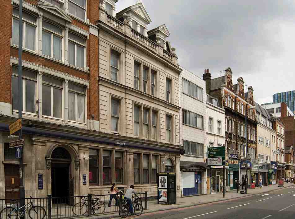
467. Nos 242–270 Pentonville Road (right to left) in 2007
The earliest of these was a branch office of the London & County Bank, built in 1883–4 and later extended (Nos 266–270). The original building, at Nos 266–268, was designed by Glover & Salter, architects, and built by T. Rider & Son. It is faced in Portland stone. (fn. 198) In 1928 the bank was altered and extended over the site of No. 270 with a new building, designed by H. Jones and constructed by Dove Brothers. (fn. 199) The extension, faced in Portland stone and red brick, relates neatly to the older building without closely following its style, other than on the ground floor.
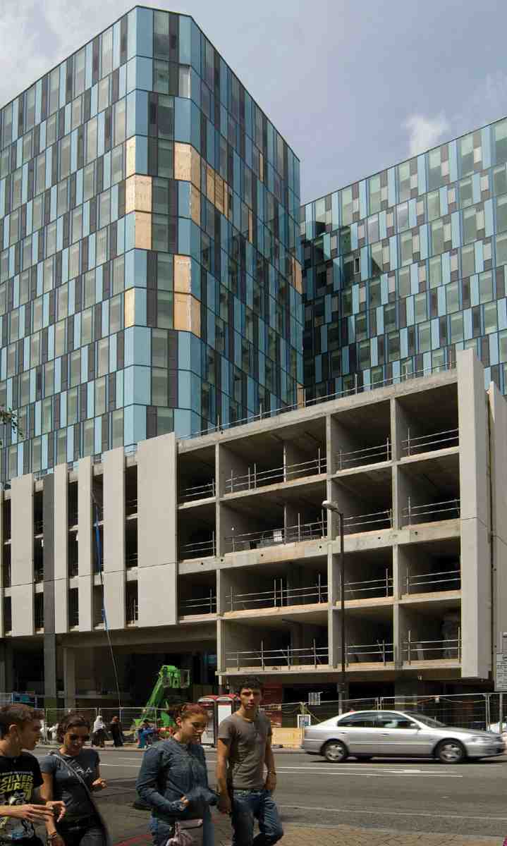
468. No. 200 (Nido London), formerly King's Cross House, in 2007. Chapman Taylor Partners, architects, 1973–82; conversion by AHMM, 2006–7
A little later than the bank, Nos 246–248, a pair of tall, Italianate-style houses with shops, were built in 1887–8 for William Hollingsworth, then owner of most of this stretch of frontage. The builders were J. Parkinson & Co. of Wood Green. (fn. 200)
No. 246, a former shop, was fitted up in 1911 as the King's Cross Cinema by F. W. Cleveland, architect. Later known as the 'Cinema de Luxe', by 1914 it had been converted to a cinema rifle range, where customers could shoot at 'life targets'. (fn. 201) This had closed by 1915. (fn. 202)
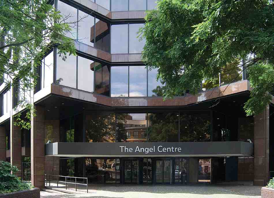
469. The Angel Centre, main entrance in 2007. Elsom Pack & Roberts, architects, 1978–83
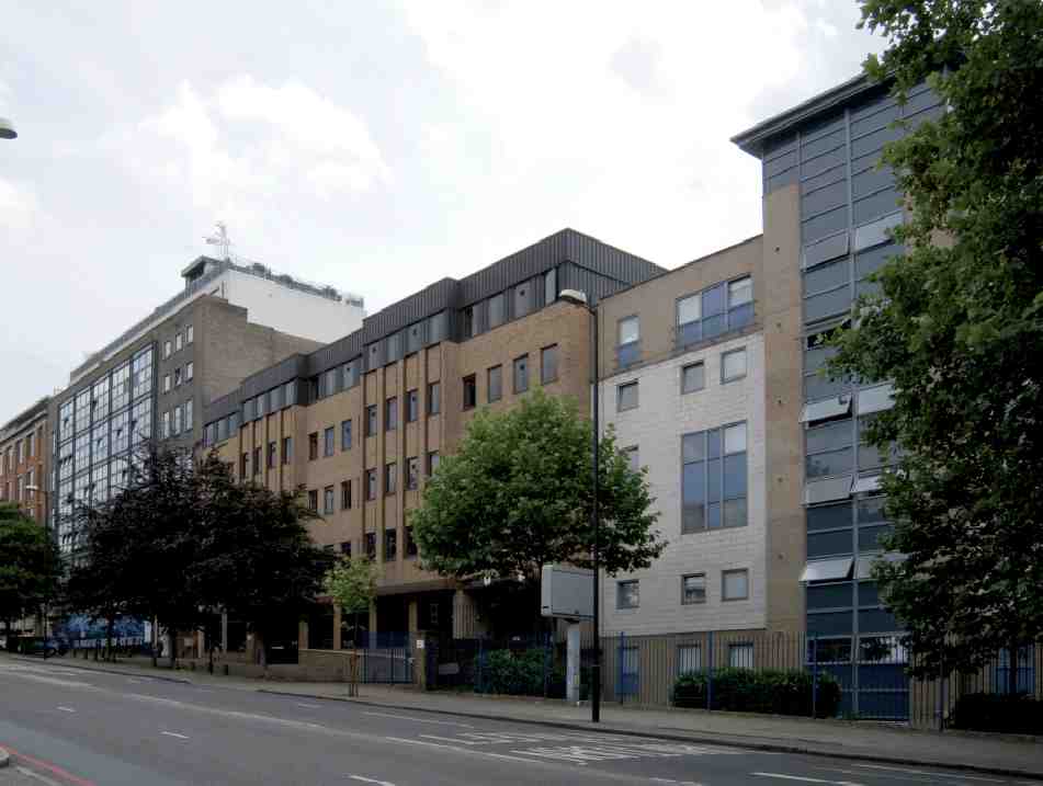
470. Pentonville Road, south side, in 2007. (Left to right) Nos 101–113, 115–123, and part of Paul Robeson House
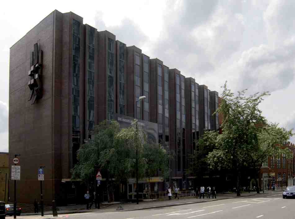
471. York House, Nos 207–221 Pentonville Road, in 2007. Alec Shickle, architect, c. 1981
The later 'free Classical' idiom is represented by the trio of shops with living accommodation above at Nos 256–260, built in 1912. Executed in stone-dressed red brick, these were the work of Charles Granville Baker, architect, of Bloomsbury Square; the builders were Rice & Son of Stockwell Road (Ill. 467). (fn. 203)
No. 242, now a drama school and studio theatre, was built in 1923 as a billiard hall with a lock-up shop (No. 244). It was part of the Lucania Temperance Billiard Halls chain, founded in Wales in the early 1900s and taking its name from a Cunard liner broken up at Swansea in 1909. Fixtures and fittings from the Lucania were bought by Welsh teetotallers to furnish their billiard rooms. (fn. 204)
Designed by North, Robin & Wilsdon, of Maddox Street, the building has a Classical façade of red brick and stone, the upper floor with an open pediment and pilasters framing a Venetian window. As fitted out, it had tables on both floors, the upper floor being of filler-joist slab construction to ensure rigidity.
The building was used for gown manufacturing after the Second World War, and was occupied by the Medical Research Council's computer unit in the 1960s. (fn. 205)
On the corner of Northdown Street, the building comprising Nos 236–240 Pentonville Road and 1–9 Northdown Street dates from c. 1930. It was erected to designs by Waite & Waite of Great Castle Street as shops with workshops and offices over, and factory premises behind. (fn. 206) The stripped-Classical red-brick façade has suffered the loss of the original metal windows and the imposition of another storey. Until the 1960s the building was occupied by British Watch Cases Ltd, manufacturers and distributors of the popular Trebex brand of watches, and was long known as Trebex House. In the 1970s it was taken over as offices by the British Railways Property Board (London Midland Region) and became King's House. Occupants since then have included the Big Issue magazine. (fn. 207)
The white-glazed tiled façade of No. 264 dates from the early 1970s, when the existing building was remodelled by Raymond J. Cecil & Partners. The building is now a doctor's surgery. (fn. 208)
South side: St John Street to Claremont Square
When the New Road was created, the land on the south side east of Amwell Street was in two freeholds. One, at the corner with St John Street, where the Angel Centre now stands, had been part of a field belonging to the Angel Inn and cut in two by the New Road. The other, much the larger, belonged to the New River Company, and the buildings erected there (Nos 25–75) are dealt with more fully in Chapter VIII.
Together with much of the frontage on the north side immediately opposite, this was the last part of the New Road to be built up, from about 1818 until the mid- 1820s. The easternmost houses (later Nos 1–23, now demolished), originally Angel Terrace, were built in 1818–20 under lease from Daniel Sutton, the Kensington developer, and William Dyke Whitmarsh of Salisbury, between whom the land had been divided as part of the settlement of the Angel estate (see page 443). (fn. 209) These were mostly three-storey, third-rate houses, with front gardens and small kitchen blocks at the ends of their back yards (see Ill. 426, pages 330–1). (fn. 210) More dwellings, stabling and workshops lay behind these houses, in Field Place and Medcalf (otherwise Metcalfe) Place.
On the New River ground Nos 25–75, formerly Claremont Terrace, were built in 1818–24. They are the longest run of first-generation buildings left on Pentonville Road, and the best indication of its former character, with their long front gardens and attractive cast-iron balconies (see Ills 251, 252 on pages 198–9). Some of these houses originally had stabling behind, in Claremont Mews.
Close to a busy junction, the Angel Terrace houses were by the early 1900s mostly in use as warehouses, shops and lodging-houses. (fn. 211) Much later they were blighted by the long-standing plan to widen the Angel intersection, and eventually demolished in the late 1970s for the building of the Angel Centre.
The Angel Centre
In 1978 the decision of the Labour-controlled Islington Council to approve plans by London Merchant Securities for a 200,000 sq.ft office complex on this corner was highly controversial. Until then the council had hoped to see the site—occupied by dilapidated houses at Nos 1–25A Pentonville Road and 401–445 St John Street— redeveloped for housing and light industry. (fn. 212)
Although the Greater London Council's scheme to take all this property for improving the road junction was revoked, the finished building was set back to allow for widening St John Street (see Ill. 427). Designed by Elsom Pack & Roberts, the development comprises two buildings. The main block is faced in red granite and pre-cast aggregate, but its most obvious feature is the wide expanse of bronze non-reflective float glass, framed in dark-brown anodised aluminium (Ill. 469). (fn. 213) To the south, a smaller block screens the site from the rear of properties in Chadwell Street. This was designed in a red-brick pastiche late Georgian style, intended to blend with the early nineteenth-century New River estate houses there and in St John Street—as the local conservation officer pointed out at the time, the illusion was undermined when the long strip-lights came on, revealing the reality of open-plan offices within.
Begun in 1979, the development was not finished until 1983. The main building was let to British Telecom in 1984; the other block is occupied by the National Probation Service. (fn. 214)
Claremont Square to Penton Rise
The ground here belonged to the eastern of the Clay Mantles, two fields cut through by the New Road. The frontage was built up in 1769–70 with an irregular row of twenty-one houses called Queen's Row (later Nos 95–135), one of the earliest parts of the Penton estate to be developed. In 1764 William Lloyd, a St Marylebone plasterer, had undertaken to build, but nothing came of it and the site was eventually built up by William Meymott, a Bermondsey carpenter, later described as a surveyor. (fn. 215) The name was in honour of Queen Charlotte, replacing the original name Prospect Row about 1773. (fn. 216)
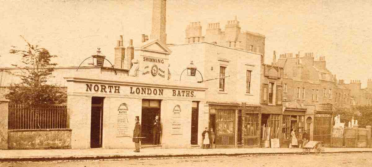
472. Entrance to North London Baths and part of Queen's Row, c. 1863–5. All demolished
The houses, mostly of three storeys, stood on plots with 18–24 ft frontages. They had long front gardens, the back gardens varying owing to the taper of the site (see Ill. 528, page 406). There were two appreciably larger houses, one later subdivided as Nos 123, 123a and 123b, the other No. 135.
At the west end of Queen's Row, the east side of Penton Place (now Penton Rise) was let to the watchmaker Alexander Cumming and built up during the early to mid-1780s, the easternmost part with buildings fronting the New Road (see Ill. 387). These included Cumming's own residence (see page 301). (fn. 217)
Beyond the east end of Meymott's development, a triangular plot with a pond ran nearly up to the New River Company's reservoir. This site, recently drained and enclosed with a dwarf wall, was let in 1817 to Henry Hammond, a Holborn glazier who was involved in developing part of the New River Company's estate and went bankrupt the same year. A few more houses were subsequently built there, and by the mid- 1830s, if not earlier, baths. (fn. 218) Known as the Pentonville Baths, and later the North London Baths, these were given an ornamental, pedimented street-front in 1863, the baths being contained in a long, top-lit structure behind (Ill. 472). Swimming lessons were provided, and there were also warm private baths. But it may also have been more generally an entertainment venue. A Victorian handbill survives announcing the 'Great National Circus' to be held there. This was by the famous circus family, the Fossetts, and top of the bill was Madame Fossett, tight-rope artiste. The circus was 'Only open 3 nights, then put down'. (fn. 219) The baths closed about 1902, and the site was sold as freehold shortly afterwards to the New River Company. (fn. 220)
Queen's Row provided 'spacious and genteel' residences for gentlemen in the 1790s and early 1800s, and retained a number of 'Esquires' into the 1840s. (fn. 221) Though increasingly in commercial use, almost all of Queen's Row kept its neatly laid out front and rear gardens beyond the mid-1870s, except at the shallower properties near the baths, where there were a number of shops by the 1860s. More forecourts were built over with shops when new 42-year leases were granted in the mid-1880s. These were occupied by various sorts of shop, with a few craftsmen such as gilders, carvers, and musical instrument makers. (fn. 222)
As with most of the road, the character of the neighbourhood deteriorated in the early 1900s: several houses were reduced to common lodging-houses, and many shops stood empty and dilapidated. Their depreciation was recorded by Inland Revenue valuers in 1912, who noted a house at No. 133, divided up and let to poor weekly tenants, which had been held on a 35-year lease since 1884 at £32 per annum, but recently re-let for a much shorter term at only £25. (fn. 223)
The present buildings are mostly of the late twentieth century. The oldest is the former Claremont Garage at Nos 79–89, built partly over the back gardens of the houses on the west side of Claremont Square and requiring the demolition of Nos 1 and 1A there (Ill. 473). Now a storage facility, it was built in 1922–5 for the Midland Auto Engineering Works, and was described as a motor omnibus garage or coaching station. The architect was A. H. Lester and the main contractors were Levy & Lester of York Road. The long, roughly L-shaped building is steel-framed and faced in red and stock brick with cement and stone dressings, with a concave façade to allow an easy pull-in for vehicles behind petrol pumps on the forecourt. Intended as offices and showrooms, it had a ramp up to the first floor in the rear wing. (fn. 224)
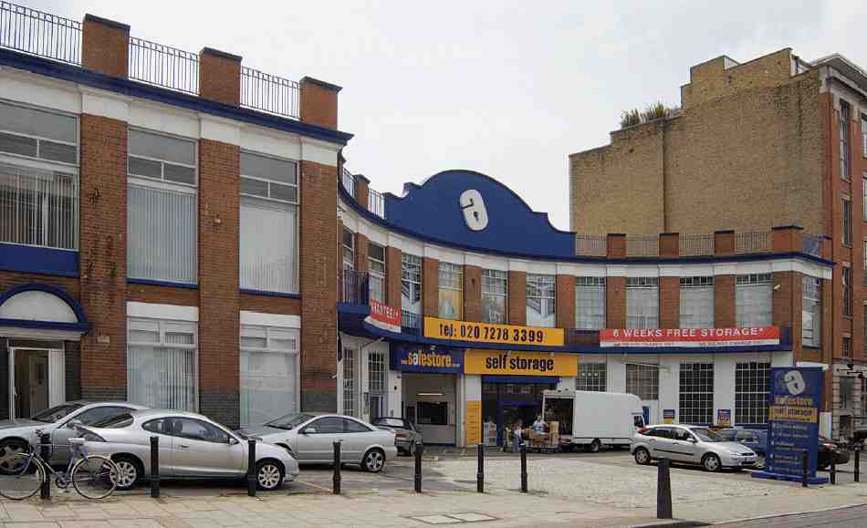
473. Former Claremont Garage, Nos 79–89 Pentonville Road, in 2007
Nos 91–99, City Gate Place, is a former factory, of five storeys over a basement, and was built in 1937–8 for the Ormond Engineering Co. to designs by Lewis Solomon & Son. Ormonds were an important concern locally, with four factories in Finsbury after the war, manufacturing screws, radio parts, and bakelite electrical goods such as hairdryers and wireless sets. This was part of an extensive works in Holford Mews or Yard behind (see page 228 and Ills 278–9). (fn. 225) Beneath the stripped-Classical façade of red-brick pilasters and stone detailing is a steel frame, with steel filler-joist floors. (fn. 226)
By the early 1950s the building had been taken over by the Post Office for its supplies depot, and by 1959 Ormonds were erecting a new factory at No. 189 Pentonville Road (now demolished). (fn. 227) In the early 1970s, Nos 91–99 became the photographic archive, studio and offices of the Department of Environment's Property Services Agency. It was later used as offices and warehousing by British Telecom, until 1994. (fn. 228) In 1996–8 it was converted to residential apartments by ORMS architects for City & General Estates Ltd as City Gate Place. The conversion included a car park in the basement and two penthouse flats constructed of steel beams on hollow columns fixed to the existing roof slab. The contractors were BMP Building Ltd of Hampshire. (fn. 229)
Nos 101–113 was built in 1963–4 as a warehouse and showroom speculation, with ancillary offices, to designs by Lewis Solomon, Son & Joseph. The contractors were William Moss & Sons Ltd of Cricklewood. Constructed on a reinforced-concrete frame, it has curtain-walling of brick and concrete (Ill. 470). The principal occupants from 1966 were the British Standards Institution, whose main testing laboratory was here. During their tenancy the building was known as Newton House; it has been used as offices since the mid-1980s. (fn. 230)
Nos 115–123, Myddelton House, is a five-storey office building of 1982, faced in buff and brown brick, with bronze sheet cladding to the upper floor (Ill. 470). The architects were the Bader Miller Davis Partnership of Great Russell Street. It is currently the headquarters of Citizens Advice. (fn. 231)
Paul Robeson House and James Lighthill House occupy the site of the former steel-stockholding depot of Macready's Metal Co. Ltd. This comprised an extensive range of brick-faced warehousing and offices, stepping down the hill at Nos 131–135, round the corner and down Penton Rise. The original plain three-storey warehouse, set well back from the road, was designed by M. Stanley Blanchfield of Raynes Park and built in 1935. In the 1950s a large office and warehouse extension was built in Penton Rise to the designs of John K. Greed (see page 304 and Ill. 394), and in the early 1960s another range was built alongside the 1930s warehouse, fronting Pentonville Road. Again designed by Greed, this exactly matched in style the Penton Rise building. The site was called Usaspead Corner, after a type of steel bar supplied by the firm, which moved to Rugby in the early 1990s. It was cleared in 1993, but another part of the works on the north side of the road survives (see Nos 136–150 above). (fn. 232)
The present buildings, numbered 1 and 3 Penton Rise, were designed by T. P. Bennett Architects as student residences for the School of Oriental and African Studies (SOAS), part of the University of London. (fn. 233) Each comprises mostly single rooms with bathrooms en suite, arranged like large shared apartments in 'clusters' of five to seven rooms around communal kitchen and dining facilities. (fn. 234)
Paul Robeson House, erected in 1997–8, is now owned and managed by Shaftesbury Student Housing, part of the Shaftesbury Housing Group, and is reserved for SOAS post-graduate students. James Lighthill House, finished in 2000, was sold by SOAS to University College, London; in December 2006 a 20-bedroom annexe was being added by Levitt Bernstein Associates. (fn. 235)
The buildings are named in turn after Paul Robeson, the American singer and black-rights activist, who studied African languages at the University of London in the 1930s; and Professor James Lighthill (d. 1998), applied mathematician and former provost of UCL. (fn. 236)
Penton Rise to King's Cross Road
The greater part of the frontage here belonged to the Penton Estate, and was built up with houses in the late 1780s and 90s by the brickmaker John Weston—Clarence Place and York Place, later numbered 177–205 and 207–237 Pentonville Road (see Ills 426, 528). (fn. 237) A small strip at the east end remained unbuilt on, where the gardens of Weston's houses in Penton Place (now Rise) came up to the road. At the west end a small portion of ground, forming the apex between the New Road and Bagnigge Wells Road, belonged to the manor of Cantelowes, together with the frontage to Bagnigge Wells Road itself. Hornor's map (1808) shows this triangle partly occupied by sheds or workshops, which seem to have belonged with No. 1 Hamilton Row at the top of Bagnigge Wells Road, occupied in the 1840s and perhaps for some time earlier by a cowkeeper. By this time three houses had also been built on this short stretch of the New Road, which had acquired the name Bingley Place. (fn. 238)
Weston's houses, mostly of three storeys, with basements (Ill. 432), were gentlemen's residences until about the middle of the nineteenth century, when trade and industry became predominant. Occupants in the 1840s included William Bernard Cooke, artist; Henry Bryan Hall, portrait painter, and the sculptor Charles Physick. (fn. 239)
An early manifestation of the changing character of the area was the erection in the 1840s of a row of two-storey shops over the Penton Place gardens (Lower Queen's Row, later Nos 137–175 Pentonville Road, see Ills 474, 476). (fn. 240) In 1888 single-storey brick shops, with flat zinc roofs, were built in front of Nos 207–217 (west of Lorenzo Street) by the new lessee, James Gordon Walls, a City solicitor. The work of John Farrer, architect, they took the numbers 207A–217A. (fn. 241) More shops, some single-storey, some two–storey, were also built at Nos 219–231, again mostly by Walls, and probably at about the same time.
Walls' most substantial improvement was the erection of two blocks of dwellings at Nos 233–235 and 237–239, originally called Gibson House and Gordon House, which survive as offices, occupied since the early 1970s by the charity Community Service Volunteers. (fn. 242) Built in 1889, these were designed in the Arts-and-Crafts manner, with a mix of red and stock bricks and white-painted plaster, to the designs of W. Youlle of Great James Street, Bedford Row (Ill. 475). The builder was James Hunt of St John Street. (fn. 243)
Each building contained eight three-roomed dwellings, arranged over four floors above the ground-floor shops. Early occupants included the families of a railway clerk, an American meat agent, an actress (Annie Blunt) and her lodger. By 1901 there had been a drop in social status, households then including those of a packing-case maker, shoe-blacks and a lavatory attendant. (fn. 244)
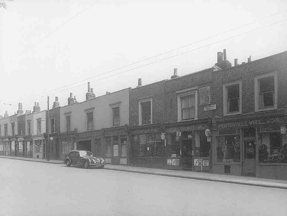
474. Part of former Lower Queen's Row, Nos 151–175A Pentonville Road (left to right), in 1959. Demolished
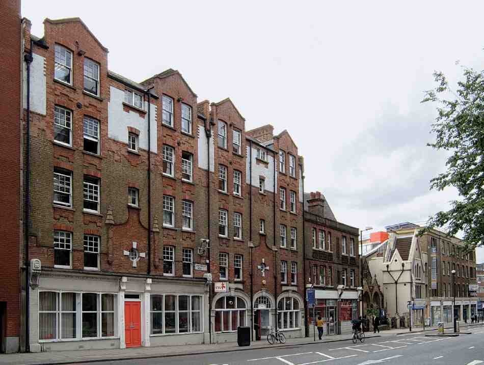
475. Nos 233–245 Pentonville Road (left to right) in 2007
In the old houses near by, the social and economic decline common to much of Pentonville was more marked. Nos 137–205 were described in 1898 as 'very rough', with broken windows, the resort of 'noisy young thieves'. (fn. 245) At Nos 207–217 most of the shops were empty and deteriorating by about 1911, and the houses behind let in tenements to a very poor and generally undesirable class of tenant. (fn. 246)
After Walls' efforts, redevelopment seems to have petered out, though the City of Bristol public house and the shop next door (Nos 241 and 243) were rebuilt in 1902–3, by the Forest Hill Brewery Co.; they are plain buildings, faced in stock brick with red wire-cut brick dressings (Ill. 475). (fn. 247)
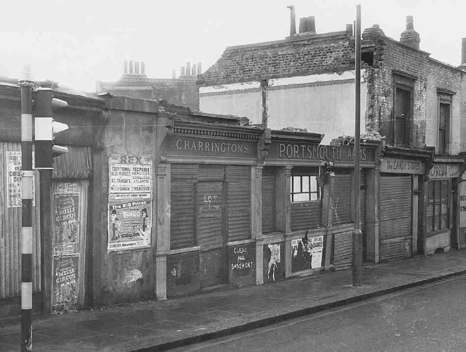
476. Part of former Lower Queen's Row, Nos 139–149 Pentonville Road, in 1963. Demolished
Many of the houses and shops survived in lightindustrial use—such as printing, plating and the rag trade—until the 1960s. (fn. 248) None of the original buildings now survive. Between Penton Rise and Weston Rise is part of the Weston Rise housing estate, described in Chapter XII. West of this, in addition to the buildings described above, are a former Congregational chapel of the 1850s and a series of late twentieth-century blocks.
Of the newer buildings, the largest is Dinwiddy House (Nos 189–205), between Weston Rise and Lorenzo Street. Designed by T. P. Bennett Architects, this was built in 1996–7 for the University of London's School of Oriental and African Studies, and contains accommodation for more than 500 undergraduates. It is ranged around a courtyard, stepping down the sloping site, the rooms being grouped in two U-shaped wings of differing height, linked by central lift and staircase wells (see Ill. 428, page 337). Stylistically the building differs a little from the architects' other work for SOAS near by (Paul Robeson House and James Lighthill House, above), having warmer buff facing bricks and green panels. (fn. 249)
York House (Nos 207–221), built about 1981, was one of the earliest office blocks built on Pentonville Road. Despite having already allowed the very large King's Cross House development opposite, Islington Council still did not consider this a suitable location for offices, and it was only allowed after a planning appeal in 1979. (fn. 250) The accepted design, by Alec Shickle for Trafalgar House, was typical of the period, finished in dark plum brick, with tall narrow bays of tinted solar-glass windows, on a reinforced-concrete frame (Ill. 471); the builders were Trollope & Colls Ltd. York House has recently been refurbished as a mixture of offices, apartments and 'live-work' units by Currell New Homes. (fn. 251)
Another office block, Caledonia House (Nos 223–231) was built in 1990 for Reinhold plc, in anticipation of the high-speed Eurostar rail link at St Pancras (completed in 2007) and the expected regeneration of the area. Its relatively conservative elevation, clad in red 'Dawire' bricks on an Italian granite plinth, was a revision of an earlier, unsuccessful design in 1989 for a predominantly glass building with an enamel framework. At the rear is a landscaped garden, which it was intended should be shared by the office-workers with a hostel for homeless women adjoining in King's Cross Road, as an example of 'planning benefit'. The architects were Michael Squires Associates. (fn. 252)
Former Welsh Tabernacle
This chapel, more prepossessing inside than out, was built in 1853–4. Known at first as Battle Bridge Congregational Chapel, and later as Bingley Place Chapel and Pentonville Road Chapel, it was taken over by a Welsh congregation in 1889 and remained their place of worship until 2006, latterly under the name of Capel Elfed.
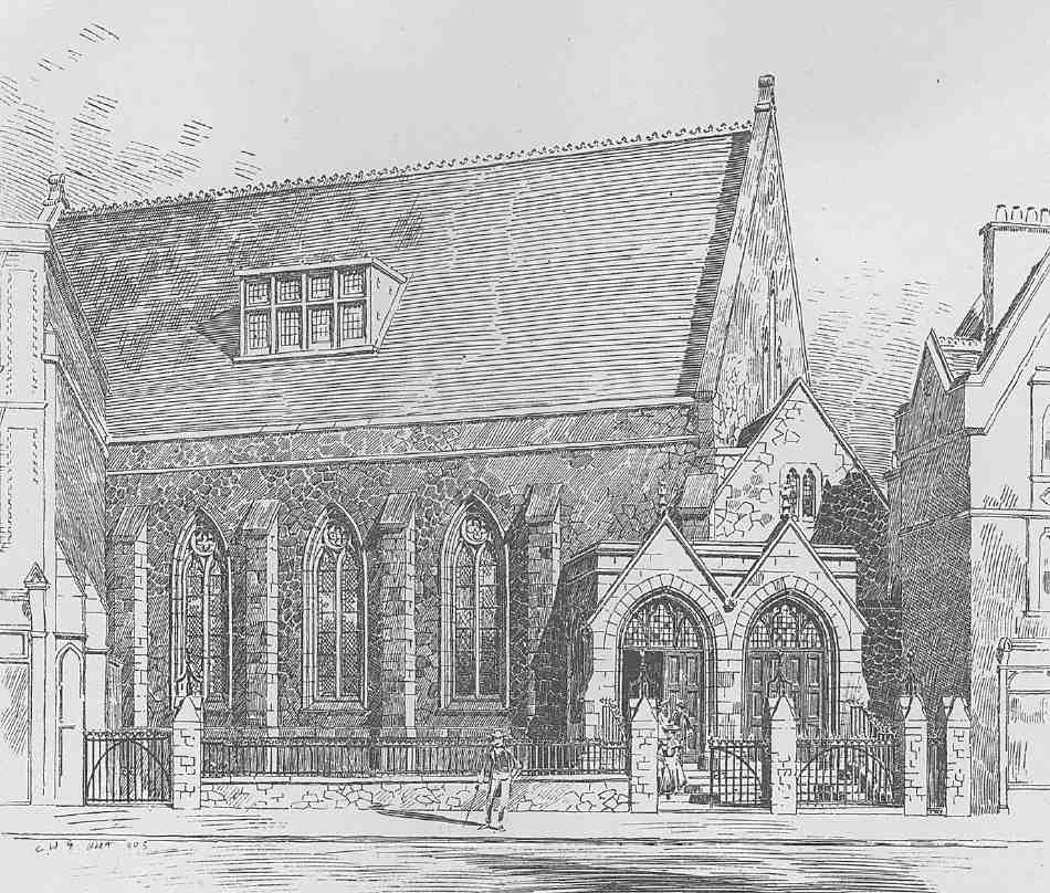
477. Welsh Tabernacle (Welsh Congregational Church), Pentonville Road, in 1904, as extended by Alfred Conder
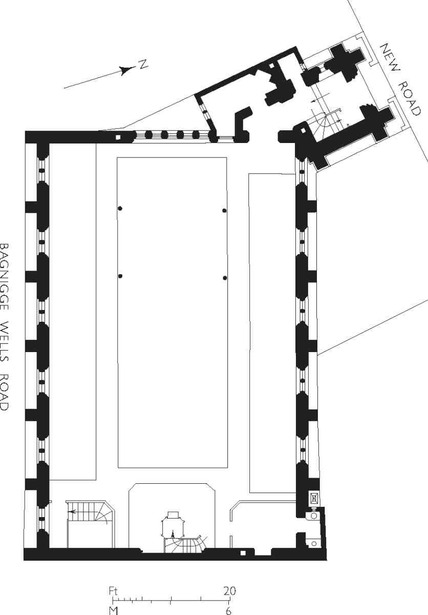
478. Congregational chapel (later Welsh Tabernacle), Pentonville Road, plan as originally built. Henry Hodge, architect, 1853–4
The chapel originated, at a time of expansion for London Congregationalists, with the Rev. Thomas Seavill, who was keen to minister to 'the working classes of this very populous and neglected locality'. (fn. 253) He was 'pecuniarily and otherwise assisted by John Morley, John Finch, and Eusebius Smith, Esqrs., and other wealthy gentlemen', stated Pinks. They accumulated funds enough to buy for £2,000 the present narrow site, a mixture of freehold and copyhold properties wedged between what were then still the New Road and Bagnigge Wells Road, and to build a chapel to the value of £5,000. (fn. 254) Its designer was Henry Hodge, a young architect who had previously built a Gothic congregational chapel in Kentish Town. The builders were Rowland & Evans. (fn. 255)
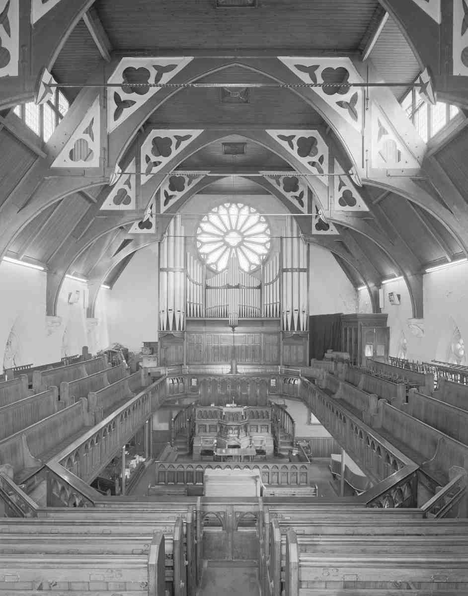
479. Welsh Tabernacle (Welsh Congregational Church), Pentonville Road, interior looking east in 1990
In his first design of 1852 Hodge orientated the chapel towards the south. (fn. 256) That was changed on revision to an east-facing arrangement, with the body of the building abutting Bagnigge Wells Road and angled on to the New Road (Ill. 478). Here a deep area in front with steps gave access to a school in the basement; a low tower, planned at the north-west corner, was probably not executed.
As first built, the chapel failed to prosper. Pinks put the problems down to poor acoustics and 'the non-erection of galleries', (fn. 257) but difficulty in paying off the debt on the building seems to have been the root cause. (fn. 258) Seavill having resigned his ministry in 1857, the enterprise passed into the hands of the London Congregational Chapel Society, which promptly erected the galleries always intended. Under the Society's aegis the chapel continued until 1889, when because of declining numbers the London Congregational Union, as it had become, agreed to sell it to a branch of the Welsh Congregational Union that had been meeting in Fetter Lane.
Under the fresh arrangement the chapel flourished anew as the King's Cross Welsh Tabernacle, notably during the long pastorate (1904–40) of Howell Elvet Lewis, poet, hymnographer and preacher, commonly known by his bardic name of Elfed. (fn. 259) His arrival coincided with the completion of alterations and additions to the designs of Alfred Conder. (fn. 260) Since then there have been few changes. The chapel closed in 2006 and is for sale at the time of writing.
The exterior of the chapel today is cramped at both ends, and presents rather forlorn flanks to the two streets between which it sits. At first the west end was fairly open to view, and as John O'Connor's painting of St Pancras shows (Ill. 429), its high pitched roof was conspicuous from a distance. The building is in a simple Gothic style veering between Early English and Decorated. The facing materials are Kentish rag laid randomly, with dressings of Caen stone but tracery and doorways cast from Ransome's patent stone. (fn. 261) The Pentonville Road front is partly concealed by houses. Hodge's original porch was smaller than the present double one of faience, one of Conder's improvements in 1904, which allowed separate access to the main floor and, by way of a new staircase, the galleries (Ill. 477). Behind it is the gabled stump of a projected tower, probably all that was built of a short, pyramidally roofed affair illustrated in 1856. On the King's Cross Road side the buttressed flank of the chapel is complete but has been compromised by poor repairs and the raising of the pavement, making the door at its west end inoperative. Originally the plainness of this front, as perhaps also of its northern counterpart, was relieved by a central gable flanked by pinnacles and incorporating a small window helping to light the galleries. This doubtless disappeared in 1904, when Conder added a single dormer higher in the roof on each side to improve the lighting.
Internally (Ill. 479) the chapel is a remarkably complete specimen of Victorian nonconformity's pitchpine style. The eye is first drawn to the manful open roof, close-boarded between the trusses. These rest on identical corbelled angel heads, cast probably from Ransome's stone, and are of the hammerbeam variety; the spandrels are pierced with quatrefoils and trefoils, while wroughtiron cross-ties are anchored behind little shields attached to the main pieces. The east end is lit by a simple rose window, the west by five rising lancets. A high gallery runs right round the chapel, with seating on three sides and the organ, installed in 1904, over the fourth, its frontispiece of pipes stepped to avoid blocking the light from the rose. The organ console was brought to ground level in the 1950s. The galleries are carried on cast-iron columns, with ornamental spandrel brackets at the west end only, and have fronts enriched with pointed arches. At ground level, a complete set of pews and their platforms remains; those in the aisles are raked towards the pulpit. In the centre, the elevated pulpit and ample deacons' seat appear to be original but their position probably represents the rearrangement of 1904. The pulpit formerly stood further back, but was brought forward at that date in order to create a vestry for the minister and a new stair behind the east end of the chapel. At the west end, the lobby is part of Conder's alterations.
The main basement room below, used for a school, is generous in size and divided by the continuation of the cast-iron columns from above.
Adjoining the church is a small Gothic-style house, No. 245, now rendered and painted, with lancet windows and a gable towards the street (see Ill. 475). This was probably erected in connection with the church as a caretaker's lodge, but seems to have become a private house about 1865 and was subsequently made into a shop. (fn. 262) The building was later acquired by a builder, George Ell, together with the rest of the largely unbuilt-on apex site, which he covered in 1883 with the present plain block of shops and warehousing comprising Nos 249–253 Pentonville Road and 178–188 King's Cross Road (see page 313). (fn. 263)