An Inventory of the Historical Monuments in Westmorland. Originally published by His Majesty's Stationery Office, London, 1936.
This free content was digitised by double rekeying. All rights reserved.
'Kentmere', in An Inventory of the Historical Monuments in Westmorland, (London, 1936) pp. 129-131. British History Online https://www.british-history.ac.uk/rchme/westm/pp129-131 [accessed 19 April 2024]
In this section
48 KENTMERE (C.e.)
(O.S. 6 in. (a)XXVII, N.W., (b)XXVII, S.W.)
Kentmere is a parish 8 m. N.W. of Kendal and extending to the ridge of High Street. The former small lake has been drained. Kentmere Hall and the Village Settlement are the principal monuments.
Ecclesiastical
b(1). Parish Church of St. Cuthbert, formerly a chapel of Kendal, stands in the S. part of the parish. The walls are of local rubble and the roofs are slate-covered. The building, consisting of Chancel and Nave, is presumably at least as old as its mid 16th-century roof, but all definite evidence of its precise date was destroyed in the restoration of 1866, when the West Tower was added. The South Porch is also of uncertain date.
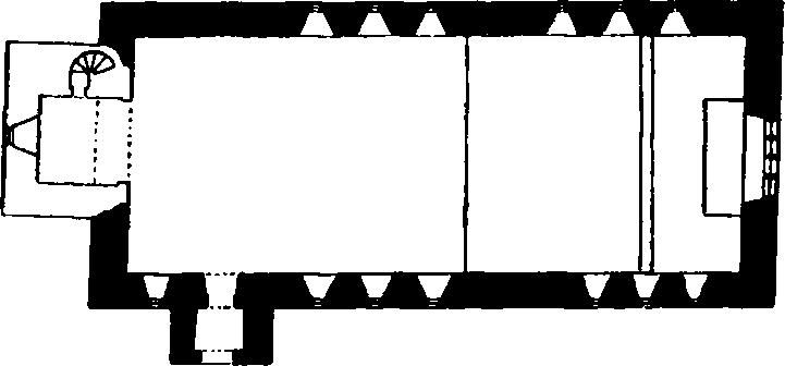
The Church, Plan
Architectural Description—The Chancel and Nave (70¼ ft. by 27¼ ft.) are undivided structurally. The E. window, perhaps of 16th-century origin but now covered internally with cement, is of four plain lights in a segmental head, with a moulded label. The N. wall has six and the S. wall seven windows with round heads and modern wooden frames; they are all cementcovered; the S. doorway has square jambs and segmental-pointed head.
The South Porch has an outer archway with square jambs and segmental head.
The Roof of the main building is of mid 16th-century date and of seven bays, with moulded tiebeams and raking struts to the principal rafters; the roof is ceiled on the upper surface of the tie-beams and divided into panels by three moulded purlins.
Fittings—Bell: one, uninscribed, said to be modern. Stools: in nave and tower—two with turned legs, 17th-century.
Condition—Good.
b(2). Kentmere Hall (Plate 116), 580 yards W. of the church, is of two storeys; the walls are of rubble and the roofs are slate-covered. The ruined pele-tower at the W. end of the house dates from the 14th century; the house itself is perhaps of the end of the 14th or of the next century, but the hall is said to have been built by Hugh Herd, temp. Edward VI; this was perhaps a reconstruction of certain parts only, as the existing detail indicates an earlier date. In the 16th century the house belonged to the Gilpin family. The kitchen-wing on the N. of the hall is a modern addition.
The house is of interest as an example of a peletower and small manor-house.
The pele-tower was of four storeys with a barrel-vaulted ground storey and a modern pent roof within the building replacing the destroyed upper floors and original roof; at the N.W. angle is a garde-robe projection and in the N.E. angle a spiral staircase. The ground-storey has a loop-light in the S. wall and a former opening in the N. wall has been widened to form a doorway. The second storey has in the S. wall an original 14th-century window of two trefoiled ogee lights in a square head with a moulded label and a blank panel above it. There are square-headed openings or loops in the walls of the upper storeys. The tower retains part of its plain parapet brought forward on corbels. The hall-block adjoins the tower on the E. and has a screen-passage at the E. end; this is entered by a doorway, at the S. end, with chamfered jambs and two-centred head; farther W. are two blocked or partly-blocked windows, one retaining its stone jambs and square head with a moulded label. The back wall of the hall has a small blocked square-headed window and the doorway to the screens has a roughly arched head. The cross-wing retains no ancient features. The hall-block has a 17th-century roof with cambered tie-beams and collars.
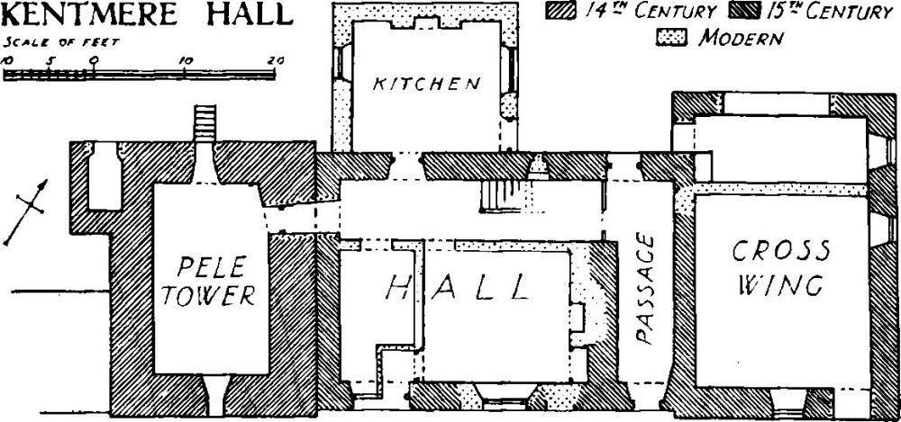
Kentmere Hall
Condition—Good, but tower ruined and ivy-grown.
Monuments (3–17)
The following monuments, unless otherwise described, are of the 17th century and of two storeys; the walls are of rubble and the roofs are slate-covered. Some of the buildings have exposed ceiling-beams.
Condition—Good or fairly good.
b(3). Croft Head, house, two tenements, 400 yards N.W. of the church, was built probably early in the 18th century.
b(4). Head Cottage, 200 yards N. of the church.
b(5). Raw, cottage, 300 yards N.E. of the church.
a(6). Rookhowe, house, 500 yards N.E. of the church.
b(7). Wray House, 230 yards E. of the church, was built probably early in the 18th century.
b(8). Maggs Howe, cottage, 620 yards E. of the church.
b(9). Bridge Stone Cottage, 130 yards W. of (8), contains an original plank and moulded muntin partition, with doors.
b(10). Lowfold, house, 100 yards S.S.W. of (9), contains two original doors of moulded battens.
b(11). Longhouses, house, 1,200 yards S.S.E. of the church, has a plaster panel on the front with the initials and date W. and D.F. 1703. Inside the building is a three-stage cupboard of the local type, with carved upper panels and projecting cornice and fascia bearing the initials and date W. and D.F. 1711. A small cupboard bears the same initials and the date 1704. Part of a partition with moulded muntins also remains.
a(12). Scales, house, 1,480 yards N.N.E. of the church.
a(13). Brockstones, house, nearly 1 m. N.E. of the church, has later additions at both ends.
a(14). Hollow Bank, house, 160 yards N.W. of (13), has been much altered and modernised.
a(15). Howfold, house, 30 yards N. of (14), has been much altered and enlarged.
a(16). Overend Farm, house, nearly 1¼ m. N.N.E. of the church, has later additions at the back. Inside the building is a muntin and plank partition of the local type.
a(17). Overend Cottage, 30 yards S. of (16).
Unclassified
b(18). Village Settlement (635 ft. above O.D.) on the S. side of the parish, 1 m. S.S.E. of the church, stands on a natural terrace, with the ground falling towards the W. The enclosure (nearly ¾ acre) is of an irregular oval shape. A modern wall has been built along the crest of the S.W. portion of the original outer bank and across the western portion of the enclosure from S. to N.; the portion of the original enclosure and bank to the W. of this wall, being in a field used for tillage, is rather more defaced even than the remainder. The excavations of 1935 showed that the foundations of the rampart were 7–10 ft. thick, edged with orthostats and having an infilling of small rubble. There were four entrances, of which those on the N.E. and S.E. were subsequently blocked. At the S.E. entrance the base-stones on the S. side of the opening turn inwards round the foot of a small mound, which would appear to be the base of some additional defence work guarding the gateway. Here, as at Hugill, the entrance opens on to a passage-way. The entrance, in the middle of the N. side, has the rampart turned outwards slightly and widened on the W. side of the opening, while internally the foundation of a later wall, which runs S.S.W. from the W. side of the gap, is again suggestive of a passage-entrance. The entrance, in the middle of the W. side, again has traces of a return wall or structure immediately against the inner side of the rampart on the S. side of the gap. Internally foundations may be seen of a roughly pentagonal central enclosure with subsidiary enclosures and hut circles as shown on the plan. The excavation of hut-circle A revealed a hearth and part of a paste armlet of 2nd-century date. Mention should be made of the incomplete traces of the foundations of a structure some 8 ft. N. of the S.E. entrance, its shape being unusual among the circular type of huts. It is probable that this structure is of later date (C. and W. Trans., N.S. I. 175).
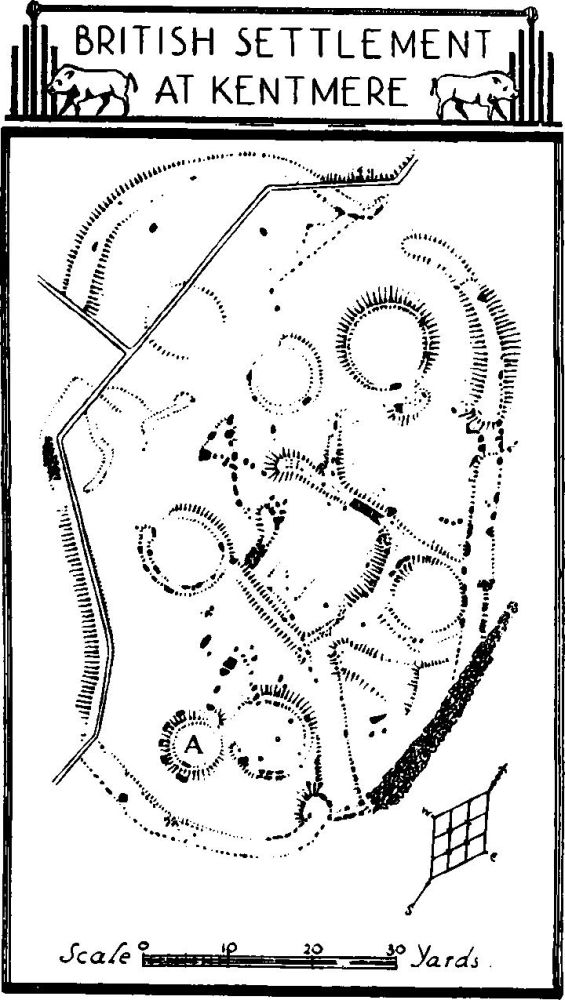
British Settlement at Kentmere
Condition—Fairly good.