A History of the County of Stafford: Volume 9, Burton-Upon-Trent. Originally published by Victoria County History, London, 2003.
This free content was digitised by double rekeying. All rights reserved.
'Burton-upon-Trent: Growth of settlement', in A History of the County of Stafford: Volume 9, Burton-Upon-Trent, ed. Nigel J Tringham (London, 2003), British History Online https://www.british-history.ac.uk/vch/staffs/vol9/pp31-46 [accessed 30 April 2025].
'Burton-upon-Trent: Growth of settlement', in A History of the County of Stafford: Volume 9, Burton-Upon-Trent. Edited by Nigel J Tringham (London, 2003), British History Online, accessed April 30, 2025, https://www.british-history.ac.uk/vch/staffs/vol9/pp31-46.
"Burton-upon-Trent: Growth of settlement". A History of the County of Stafford: Volume 9, Burton-Upon-Trent. Ed. Nigel J Tringham (London, 2003), British History Online. Web. 30 April 2025. https://www.british-history.ac.uk/vch/staffs/vol9/pp31-46.
In this section
Growth of settlement
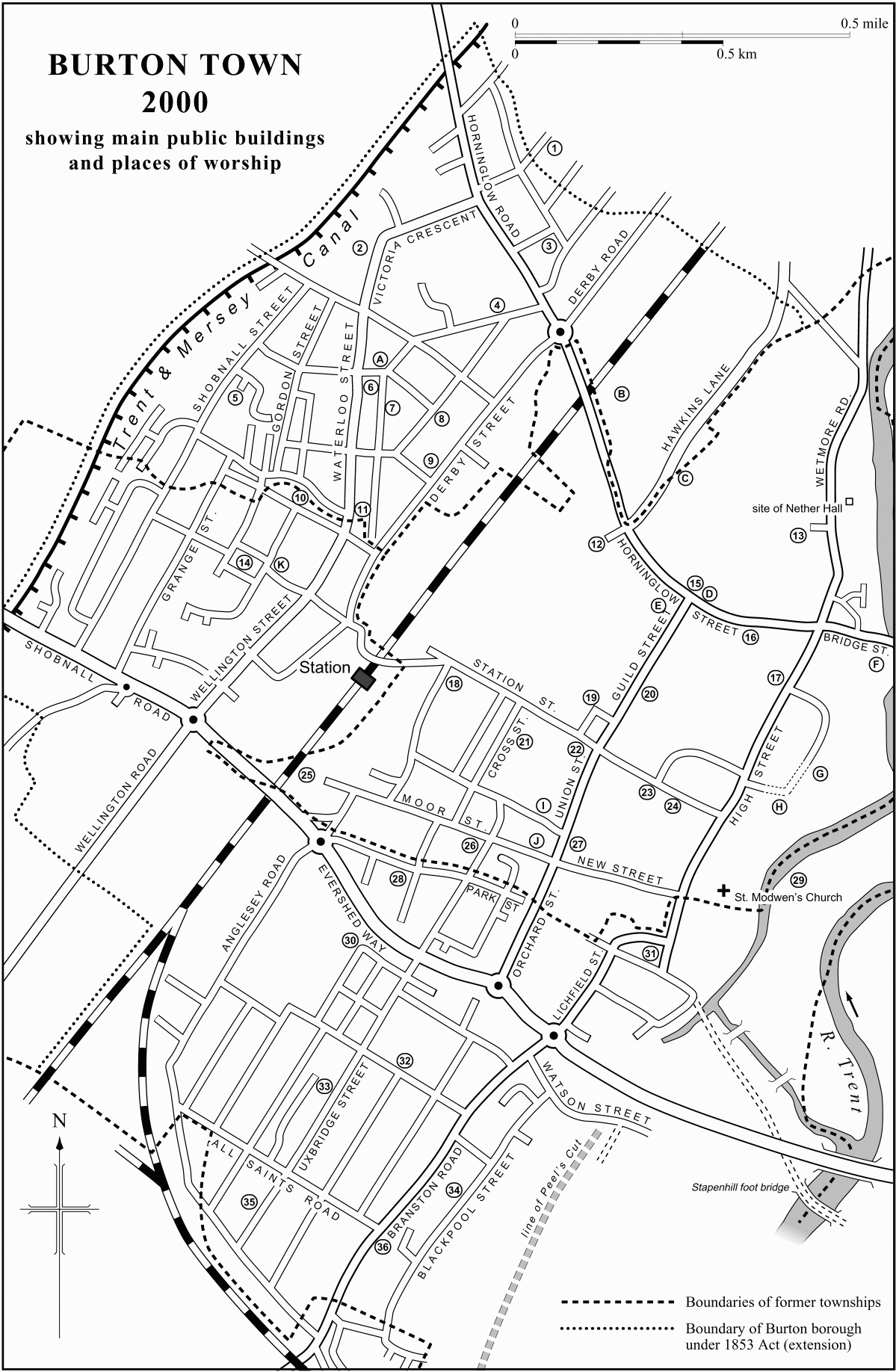
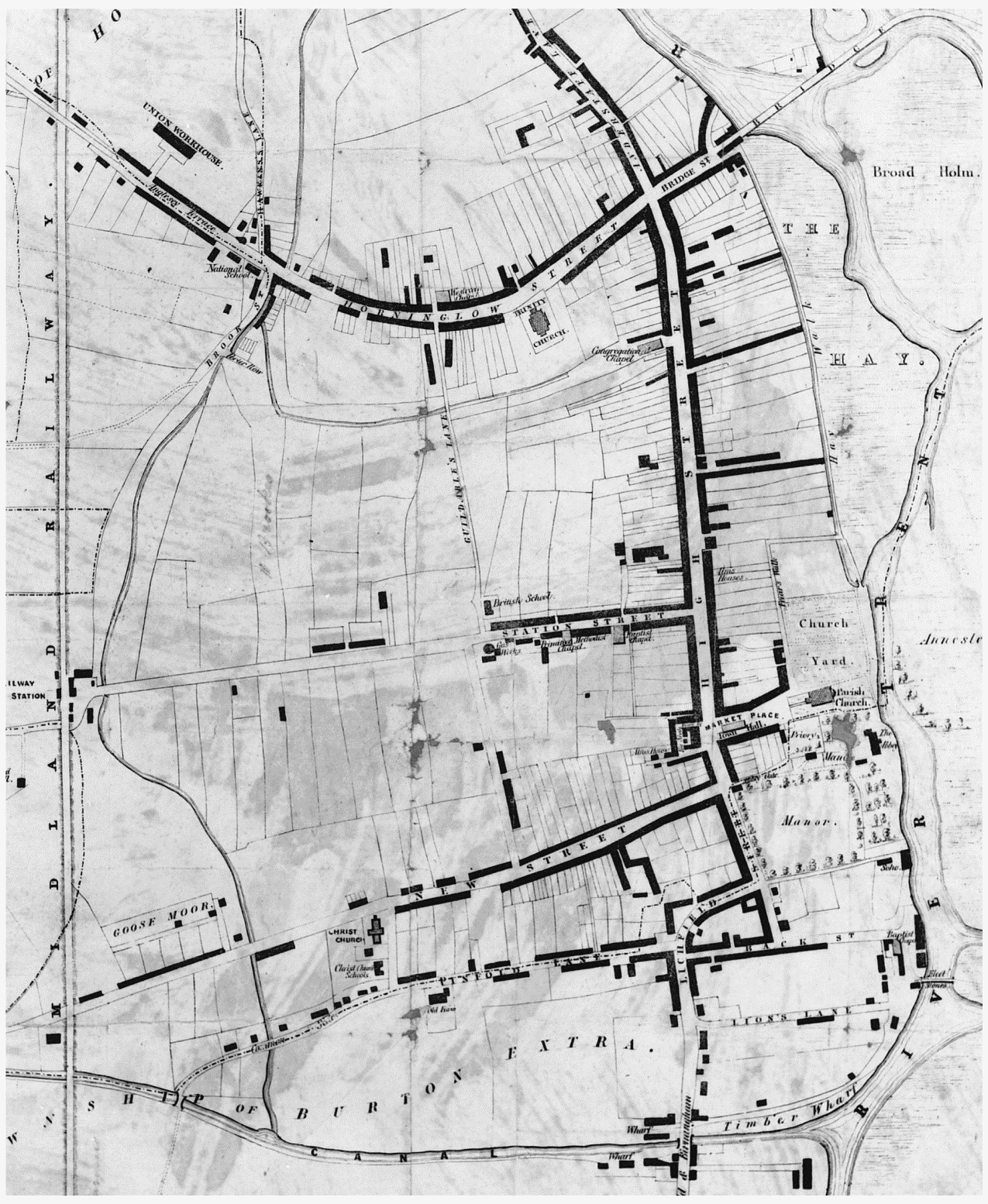
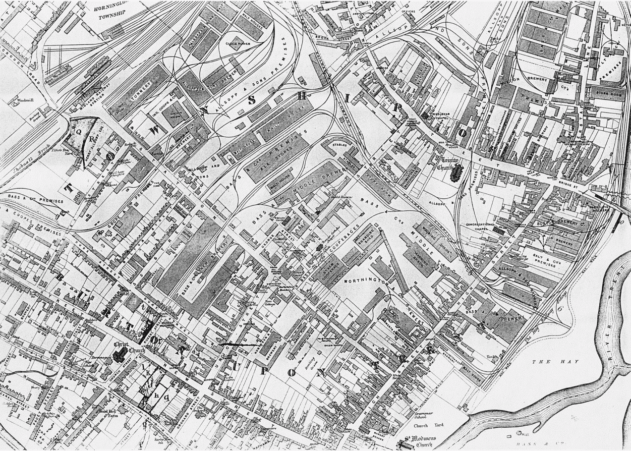
Burton town lies on the west side of the river Trent, its long High Street running northwards from a market place next to the site of the medieval abbey. The abbey church was also used by the townspeople and so remained the main focus of the town. In the 12th and 13th centuries streets were laid out off the west side of High Street, the earliest being New Street which stretched from the abbey gates towards the line of the Roman road, Ryknild Street. Horninglow Street at the north end of High Street was part of a major east-west route using the bridge over the river. The town plan remained unchanged until the earlier 19th century when expansion occurred along Horninglow Street. A railway station was opened at the west end of Cat (later Station) Street in 1839, and the area beyond the railway line up to the canal was developed mainly from the 1860s, with the creation of St. Paul's Square as a prestigious focal point in the earlier 1870s. Most of the housing both in that area and on the south side of the town towards Branston was terraced and not especially good quality, although there were no backto-backs, and from the mid 19th century Stapenhill and Winshill on the east side of the river became middle-class suburbs. Council-house estates were built in those two places after the Second World War, and more recently large private estates have been laid out in Branston and Stretton.
Much of the town centre was filled with breweries in the 19th century. Private railway tracks linked the brewery sites with the main railway line, and until they were removed in the later 20th century normal traffic along High Street especially was severly impeded by numerous level-crossings. The loss of brewery buildings has also opened up the north end of High Street, easing access to the riverside meadows.
MEDIEVAL SETTLEMENT
The Burton villani recorded in the Domesday Book entry for Burton in 1086 (fn. 5) probably occupied scattered holdings, but by the early 12th century the abbey had settled at least some of the peasants who worked its inland, the abbey's ancient endowment of non-taxable land: (fn. 6) the cottages and houses there were probably arranged according to some kind of regular plan near the abbey. The creation of permanent tenancies for fixed rents and services was a process known as an 'assise', and in the early 14th century the name 'Hautassise' was used for part of the planned settlement at the east end of what by 1457 was called Pinfold Lane (partly surviving as modern Park Street and Dale Street). (fn. 7) Two householders, William and Fromund, recorded in the abbey's early 12th-century surveys, may have been the monastic officers to whom Abbot Geoffrey (1114-50) gave permission to build houses in Burton, together with land at Stretton and Winshill. (fn. 8) Other householders were probably the abbey's specialist workers, and they included a priest who had a lodging house, possibly for pilgrims visiting St. Modwen's shrine. (fn. 9)
The Borough
The area of the borough created in the late 12th century comprised the 'vill', presumably the market place and at least part of High Street, and the 'new street' (novum vicum), the present New Street running west from the abbey gates. (fn. 10) The borough boundary ran along the ends of the burgage plots on the south side of the street as far as the line of Ryknild Street.
In 1200 Abbot William Melburne enlarged the borough by laying out burgage plots along what later became Horninglow Street, (fn. 11) and the borough was further extended in 1273 by Abbot John of Stafford at both the south end of High Street (modern Lichfield Street) and in Anderstaff Lane (modern Wetmore Road), running north off Horninglow Street. Cat Street (modern Station Street), running west from High Street, was laid out with burgages by Abbot Thomas of Packington in 1286, reportedly in order to relieve the consequences of a famine that year. (fn. 12)
Abbot Melburne's charter of 1200 stipulated that the burgage plots in Horninglow Street should be 24 perches long by 4 perches wide, (fn. 1) although slightly smaller plots were also envisaged in the charter and the abbot himself assigned plots of 20 and 22 x 4 perches. (fn. 2) On the basis of a standard perch measuring 16 1/2 feet, plots of about the required size in Horninglow Street are indicated on 18th- and 19th-century maps. There was much subdivision, however, on the north side of the street, the original 1/2-a. plots being of generous proportions and available for more intensive occupation as the town developed.
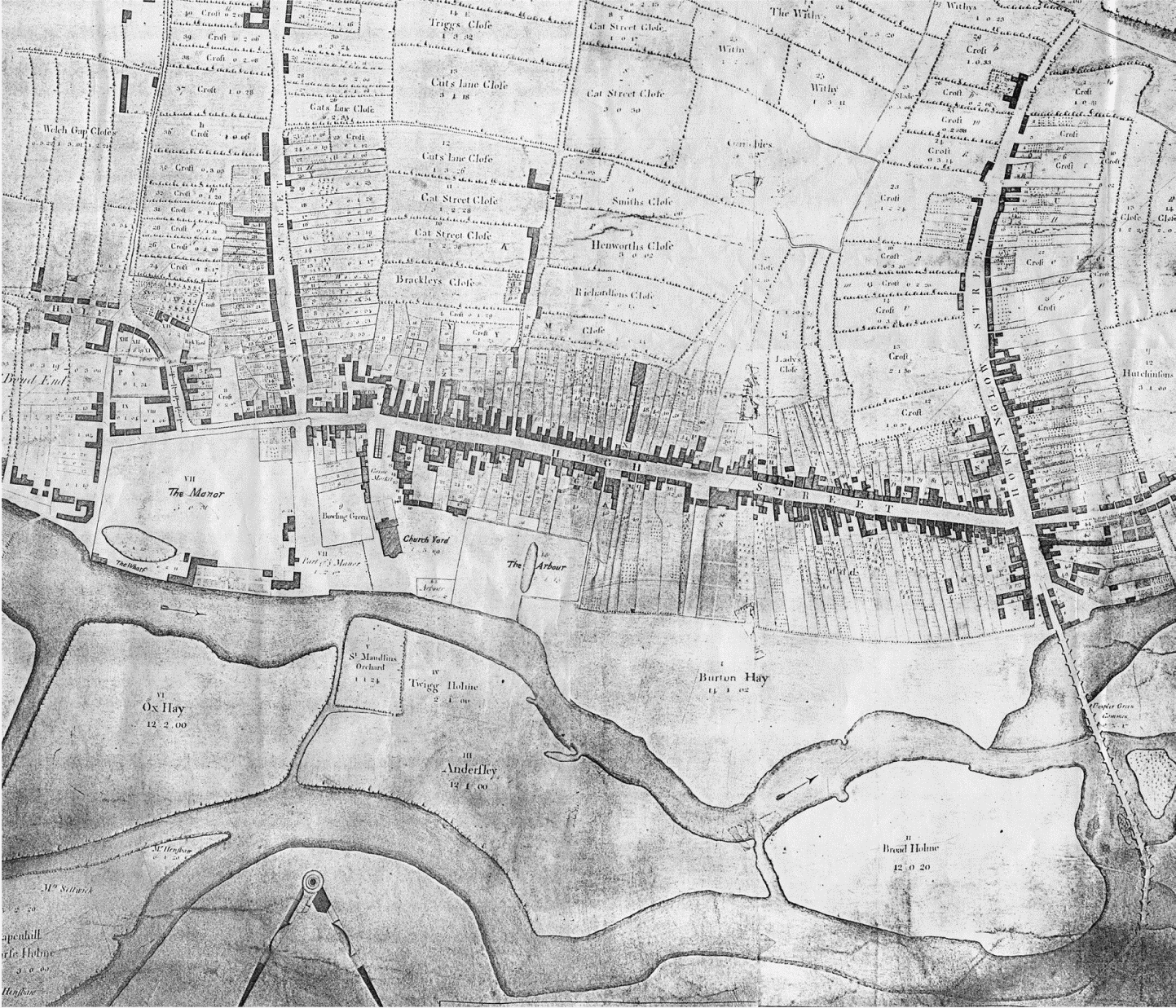
Plots on the south side of New Street were of a similar size to those in Horninglow Street but shorter on the north side, especially at the east end near the market place. There was also a block of short plots (c. 16 perches) in High Street stretching northwards from the market place, those on the east side being bounded by Friars Walk. The plots along the remainder of the east side of the street beyond Friars Walk were longer (24 perches and more) and were bounded by the Hay. Those on the west side of the street show less regularity and are interesting for their distinctive funnel shape, a layout which preserves a pre-borough drift way for cattle being grazed on the riverside meadows.
By 1317, the date of the earliest surviving rental for the borough, (fn. 3) many burgages in the central area and in Horninglow Street had been subdivided, presumably because of demand for houses, although some burgage plots at the west ends of New Street and Cat Street had either been abandoned or had never been built on.
Although there were no defensive walls around the town, a bargate ('barryat') was recorded in Cat Street in 1574 and a bar at the north end of High Street in 1579. (fn. 4) They presumably controlled the entry of traders into the town: in the 1690s a miller from Drakelow (Derb.) on his way to Burton market was stopped at the 'bargates'. (fn. 5a)
Streets
The borough's most distinctive feature topographically was its long High Street, which stretched from the market place beside the abbey church northwards up to Horninglow Street. New Street. running west from the market place, was part of the original borough, which was extended in the 13th century at the south end of High Street (Broadway) and off its west side about a third of the way up (Cat Street). Horninglow Street was part of an important east-west route across the river Trent and it was probably already a settled area when it was incorporated into the borough in 1200. There was evidently a Scandinavian homestead on the north side of the street in what became Anderstaff Lane, after it had been taken into the borough in the later 13th century. The Market Place The market place seems originally to have been an irregular rectangle stretching west from the twin-towered Romanesque abbey church and straddling High Street. (fn. 1a) A market hall was built probably in the eastern part in the late 15th century. (fn. 2)
Burton town
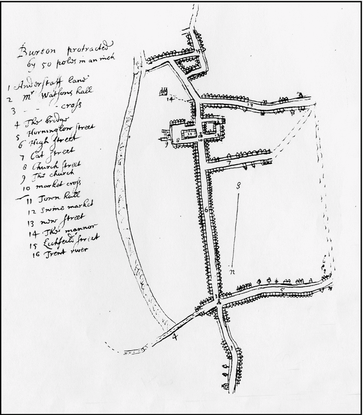
Burton c. 1679
The western part of the market place was known by the early 16th century as the swine market, and by 1550 there was a block of at least five tenements in the centre of that area. (fn. 1b) The town's first almshouse was built on the west side of swine market at the end of the 16th century. (fn. 2b)
New Street It may have been the intention when the borough was established in the late 12th century to take New Street as far west as the line of the Roman Ryknild Street (modern Derby Street): the borough boundary extended that far. In the late 17th century, however, New Street ended where modern Uxbridge Street runs off to the south, and that was probably its limit in the early 14th century. (fn. 3a) A tenant named Daddi, who in the earlier 13th century held a tenement at the east end of New Street opposite the abbey gates, gave his name to Daddy's Lane which ran a short distance off the south side of New Street. It was known as Almoner's Lane by the early 14th century, and still existed, as Almery Lane, in 1579. (fn. 4a)
In the early 14th century there was a mixture of burgages and villein holdings in the street, including at its west end ten burgage plots for which no rent was received, presumably because they were unoccupied. (fn. 5b) Two sisters, 'Dear' and 'Bettercheap', who then lived in the street close to the abbey gates were probably prostitutes. (fn. 6a)
Broadway The 1273 extension of the borough included the area from 'Bradeweye' to the 'Brere' cross, (fn. 7a) which was recorded in 1454 as standing at the south end of the town. (fn. 8a) The addition, therefore, corresponded to modern Lichfield Street, a name that gained currency only in the 19th century when it replaced the earlier name of Half Street, first recorded in 1546. (fn. 9a) The area was not wholly occupied by burgage plots in the early 14th century, when there were still a number of villein holdings. (fn. 10a)
Cat Street The extension of the borough by Abbot Thomas of Packington in 1286 opened up land called Siward moor on the west side of High Street. The intention was probably to establish burgage plots in what became Cat Street as far as the Roman Ryknild Street (modern Derby Street), and a bridge was constructed to take the road over Branston brook. By the early 14th century, however, burgage plots at the west end of the street had either been abandoned, or perhaps had never been built on: several contained selions of land, and in 1324 five burgages there were said to be 'in the fields'. (fn. 11a) Originally called 'Norreystrete' after John le Norreys, a tenant there, the street was known as Cat Street by the early 14th century. (fn. 12a)
Cat Street was then connected to New Street by Cuts ('Cottes' or 'Cuttes') Lane, (fn. 13) which by the late 17th century extended northwards as a path (later Guildables Lane) to Horninglow Street. (fn. 14) The path became the present Guild Street in the mid 19th century.
Horninglow Street and Bridge Street The decision by Abbot William Melburne in 1200 to lay out burgage plots along a street from the 'great bridge of Burton' over the Trent to the 'new bridge towards Horninglow' (fn. 15) was evidently intended to develop a major thoroughfare, where there may already have been some houses. At least part of the street was known as Newbugging (new buildings) by the later 13th century, (fn. 16) and the name Horninglow Street seems not to have been adopted until the later 15th century. (fn. 17) By 1366 the Burton bridge end of the street was known as Bridge Street. (fn. 18)
Rebuilding on at least the north side of the street in the mid 14th century (fn. 1c) took place on burgage plots that had been halved in width along the street front. The plots on the south side, however, remained mostly intact in the 17th and 18th centuries, although by then many no longer had houses on them.
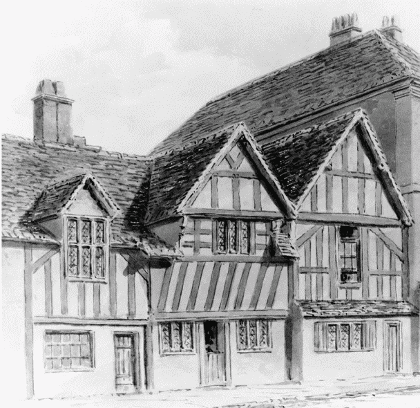
Medieval house on the west side of High Street in 1839
Burton in 1760
Anderstaff Lane Land called 'Anlastoft', on the north side of Horninglow Street, was included in Abbot John of Stafford's extension of the borough in 1273. (fn. 2c) The name means a toft belonging to Anlaf, the Old English form of the Scandinavian personal name Olafr, and may indicate an 11th-century Viking homestead. Burgage plots there lay on either side of a path leading to Wetmore, which Abbot John widened and made a route to Derby. (fn. 3a) By the early 15th century some burgages there had been abandoned as house sites. (fn. 4a) The path was known as Andesleytoft Lane in 1430 and Anlestaff Lane in 1482; the name Anderstaff Lane was in use by 1592 and remained so until changed to Wetmore Road in the late 19th century. (fn. 5c) In the later 1540s there was an inn called the Talbot, probably at the south end of the lane near Horninglow Street. (fn. 6b) Nether Hall, some distance along the lane on its east side, was the home of the Blount family when first built, probably in the 15th century. (fn. 7b)
Domestic Buildings
Besides surviving domestic buildings in the monastic precinct, (fn. 1d) a few houses in High Street and Horninglow Street (or until recent demolition) retain medieval fabric. They seem mostly to have been of a consistent urban form, each with a hall parallel to the street, and all were timber-framed. No. 51-52 High Street (west side) is an L-plan building of two storeys; its range along the street comprises two bays of a once-larger first-floor jettied hall, which has a crown-post roof with arch braces dated to 1388. (fn. 2d) Of a similar or slightly later date was no. 169 High Street (east side), demolished in 1969, a much grander building which had a chamber block with its short, two-bayed end to the street and a five-bayed wing behind; an additional twobayed block faced eastwards to the river. With heavily moulded ceiling beams and joists and jowled posts with deeply cut tracery patterns, the main block was probably attached on the south to a hall which lay parallel to the street and was rebuilt in the 17th century. (fn. 3c)
A row on the north side of Horninglow Street, although refronted in the 18th and 19th centuries, incorporates houses which retain a considerable amount of high quality, late medieval timber framing. No. 186 seems to stand on the site of an open hall running parallel to the street. It was rebuilt as the present house in the mid 14th century, as were the three-bayed, jettied two-storeyed houses with crownpost roofs at the adjoining nos. 186a-187. (fn. 4c)
Medieval Settlements Outside the Borough
Bond End About half way along the abbey precinct wall, Lichfield Street veered south-west and passed out of the borough into an area called Bond End by the earlier 14th century. (fn. 5d) Pinfold Lane, running west from Lichfield Street towards Shobnall, marked the boundary between the borough and Burton Extra township. There were a few burgage plots at the east end of the lane in the early 14th century, and further to the west the abbey kitchener acquired an estate in the late 12th century called Kitchener's Barns (later Bond End farm). (fn. 6c)
The Fleet East of Lichfield Street there was a settlement beside the Fleet, a channel of the river Trent which flowed past the abbey precinct: (fn. 7c) Thomas next to the Fleet (iuxta le Flet) occurs in the late 12th century, (fn. 8b) and by the mid 16th century there was an area called Fleetside, presumably modern Green Street, so called by 1857. (fn. 9b) An unnamed lane recorded in the early 14th century leading off Broadway to the Fleet is probably Dove Lane, so called in 1446 and known as Fleet Street since the 1850s. (fn. 10b) A parallel road to the south was known as Lion's Lane in 1694 and became the present Bond Street in the 1850s. (fn. 11b)
Shobnall The Burton entry in Domesday Book may have included a settlement at Shobnall on its western boundary. The name is Old English and means a parcel of land (halh) belonging to a man named Scobba. (fn. 12b) There were several tenants there in the early 12th century, but during the earlier 13th century the land was brought into demesne cultivation by the abbey and a grange was established. (fn. 13a)
THE EARLY MODERN TOWN
After the dissolution of Burton abbey in 1539 a college was established which occupied some of the claustral buildings. The college was in turn dissolved in 1545, but the buildings continued in lay occupancy until most of them were demolished in the early 17th century: only two remain standing (the present Abbey inn and the Manor House). (fn. 14a) The west end of the abbey church survived until the 1720s when it was replaced by the present parish church built in a classical style. (fn. 15a) The market place was further enhanced in 1772 when the lord of the manor built a new town hall to replace its medieval predecessor. (fn. 16a)
Much of the domestic housing development in the late 16th and 17th centuries was small-scale and apparently involved piecemeal renovations and additions to existing houses, as at nos. 51-52 and 169 High Street. At least one impressive house, externally of brick, was built in the late 17th century on the east side of High Street at no. 136. On an H-plan, it has two and three storeys with attics, and was built on the site of one or more medieval houses probably for the gentry Every family of Egginton (Derb.). It was occupied from the late 18th century by the brewer, William Bass, and is now known as Bass Town House. (fn. 17a) Beside some panelling in the south-east ground floor room which may have been retained from the previous house, the earliest surviving features include a grand staircase remodelled in the 19th century.
In the 1730s and 1757 visitors noted that most houses in Burton were of two storeys with garrets, and that many of those in High Street were well built with brick and ornamented with stone from a quarry at Winshill. (fn. 1e) A view of 1732 shows several substantial houses (including no. 136) on the east side of the street with large gardens running down to the Hay. (fn. 2e) A building on the west side of the street near the market place, and shown in 1732 with an elaborate stone pediment, is identifiable as the Crown inn. (fn. 3d) From the mid 18th century and especially from the 1780s, (fn. 4d) several houses in High Street, Horninglow Street, and Lichfield Street were rebuilt, or newly built, in brick, usually with three storeys and three or more bays. The rebuilding continued into the early 19th century and was tied in with the growing prosperity of the town's breweries. Most of the early breweries, indeed, adjoined the houses of their owners, as with the Bass family in High Street and the Clay family in Horninglow Street. Premises at no. 6 Horninglow Street incorporate a detached house, the lower parts of which date from c. 1630. The rest of the house is probably contemporary with an earlier 18th-century brick maltings at the rear, itself probably the earliest surviving structure of its kind in the town.
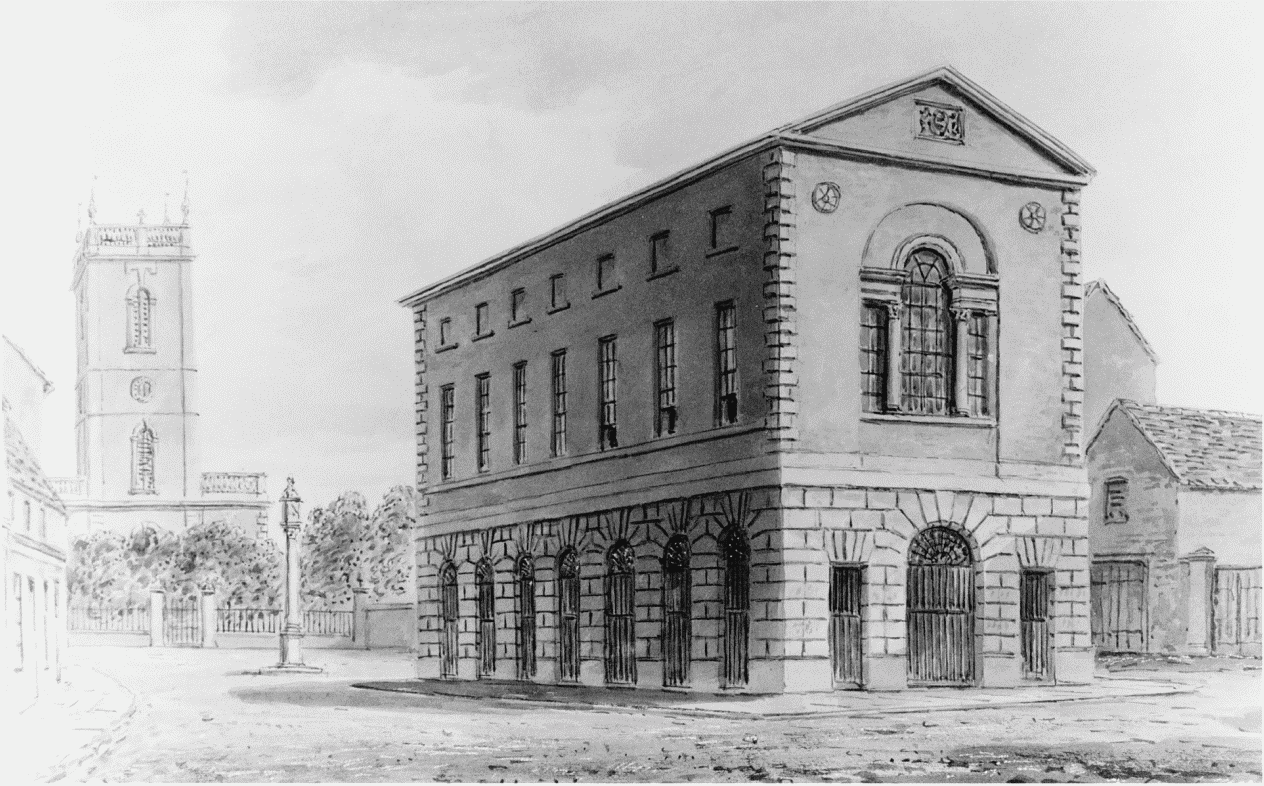
Market hall of 1772 from north-west in 1839
THE NINETEENTHTH-CENTURY
TOWN CENTRE
As brewery production increased dramatically from the 1850s, the breweries in High Street were extended and new ones built there and in Station Street, so that the whole central area of town became highly industrialized. A few public buildings, designed in styles typical for their period, enhanced the townscape somewhat. The earliest was the stone-faced county court house in Station Street, built in 1862 as an Italianate palazzo with five principal bays and three storeys, (fn. 5e) followed in 1879 by the four-storeyed Italian Gothic mechanics' institute on the east side of Union Street (fn. 6d) and the market hall of 1883 built in the south-east corner of the market place. The latter is a large iron structure with brick walls with Renaissance ornamentation. (fn. 7d) The demolition of the 18th-century town hall had the effect of opening up the market place and providing a view of the church.
Street Improvements
New Street New Street became part of the turnpike road to Abbots Bromley in 1809, (fn. 8c) the new road crossing over Goose moor which was divided up in 1823 under an inclosure Act of 1812; (fn. 9c) by 1835 there were houses along Moor Street and possibly also in a parallel street (named Stanley Street between 1847 and 1853) to the north. Between 1837 and 1847 most of the north side of Moor Street was built up, and there were certainly houses in Stanley Street by 1857. (fn. 1f) In the 1840s the New Street area was occupied mostly by poor canal workers and railwaymen. (fn. 2f) Christ Church was opened for their benefit in 1844, and the street in which it stood was known as Church Street by 1846. (fn. 3e) When the vicar of Christ Church investigated the area in 1894, he identified unsatisfactory conditions in courts and lodging houses, alleged that several houses were brothels, and described a public house at the corner of Screw Yard in Park Street as 'a perfect hell'. (fn. 4e)
Burton in 1847
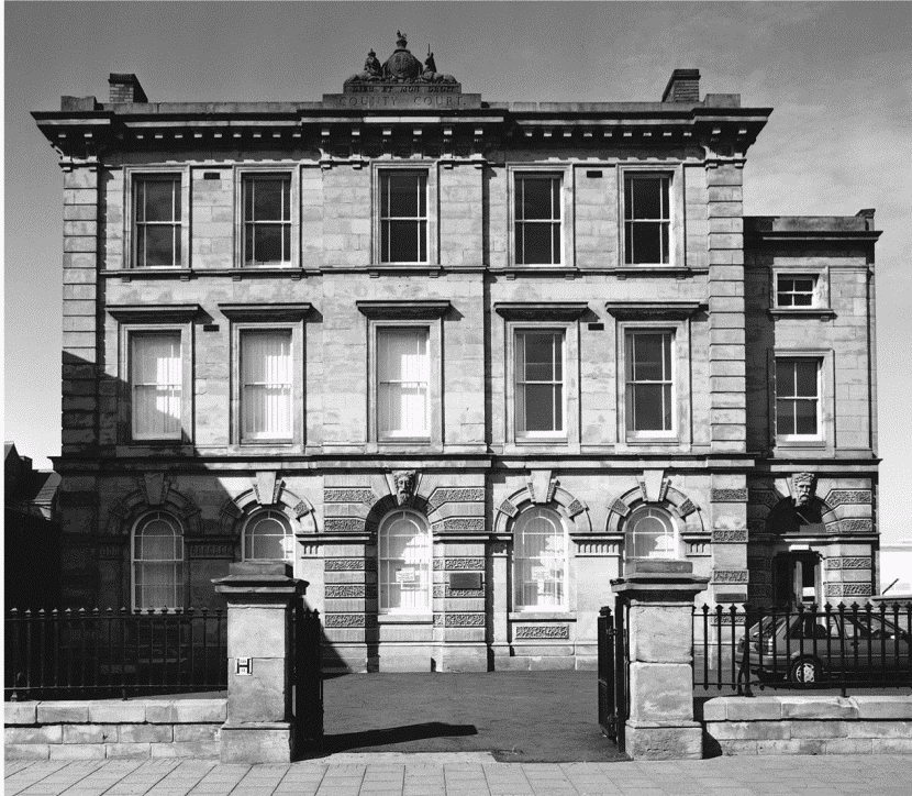
County Court, Station Street, from the south
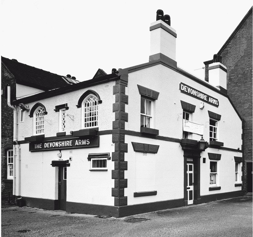
Devonshire Arms, Station Street, from the north-east
Park Street Area The eastern half of Pinfold Lane, between Lichfield Street and Church Street, had been renamed Park Street by 1846, and the western half was known as Dale Street by 1853. (fn. 1g) Orchard Street, originally an extension of Union Street as far south as Park Street, was laid out in 1854. (fn. 2g) By 1865 Uxbridge Street had been laid out (as an extension of Church Street) as far as the Bond End canal, (fn. 3f) together with Paget Street and Canal Street to the west. In the later 1860s James Street and Ordish Street were laid out to the east over what remained of Bond End farm. (fn. 4f)
Burton in 1870
Station Street (formerly Cat Street) Before the opening of the railway station in 1839 (fn. 1h) there were no houses along the western half of Cat Street (later Station Street), except for one of c. 1830 set back from the south side at the corner with the present Milton Street. That house was occupied by a nurseryman, who converted it in the 1850s into the present Devonshire Arms public house, and it still retains its original Gothick windows. (fn. 2h) Nearly opposite two short rows of houses had been built on the north side of the street by 1847 and two smart plain brick villas by 1857. (fn. 3g)
Because of the railway station Station Street became the main approach into the town centre and attention was drawn to the poor-quality houses at its east end. (fn. 4g) Although the improvement commissioners in 1853 intended to purchase the houses and widen the street, nothing was done until 1868 when those on the north side were replaced by a row of shops built in a plain Italianate style. (fn. 5f) The south side remained untouched until blocks of shops were built in the early 20th century.
Union Street By 1847 Cuts Lane between Station Street and New Street had been remade as Union Street, so called by 1853, when there were connecting streets to the west, Cross Street and Moseley (later Mosley) Street; (fn. 6e) Milton Street, on the west side of Cross Street, existed by 1855. (fn. 7e) The part of Duke Street between Milton Street and Russell Street had been built up by 1857; it was extended at both ends to Union Street and Mosley Street, and an infirmary was opened at the east end in 1869. (fn. 8d) Other public buildings included a Baptist chapel, rebuilt in a Gothic style in 1883, and the institute and library opened in 1879. (fn. 9d)
Guild Street Guildables Lane was remade in 1852 as a northwards continuation of Union Street, and was renamed Guild Street. (fn. 10c) The original plan included George Street, in the angle of Station Street and Guild Street, where a Methodist chapel was opened in the same year. (fn. 1i) By 1857 the Midland hotel had been opened at the corner of Guild Street and Station Street opposite a police station which was replaced in 1915 by a classical-style art gallery and museum, closed in the late 1970s. (fn. 2i)
Guild Street seems to have been laid out according to a plan made by Bass & Co. and was intended to ease the passage of the firm's drays to and from the railway station; another street between Guild Street and High Street, proposed by the marquess of Anglesey's agent, was opposed by Bass because it would go through their land. (fn. 3h) Such a street, together with the creation of Union Street and Guild Street, had already been suggested in 1844 by William Wesley, a Burton printer and bookseller. He noted that the extreme length of High Street gave the town a straggling appearance, and that what was needed was a 'doubling up'. (fn. 4h)
Anderstaff Lane A school was opened on the east side of Anderstaff Lane in 1847, (fn. 5g) and in 1854 houses were built towards the north end, opposite the gas works opened in 1853. (fn. 6f) In 1871 the houses included a tenement block called Duck Hall, then described as 'unfit for habitation' but still occupied in 1881. (fn. 7f) The medieval Nether Hall nearby was demolished probably in the 1870s. (fn. 8e) Anderstaff Lane was renamed Wetmore Road in 1878, when its northern part in Horninglow township was added to Burton. (fn. 9e)
NINETEENTHTH-CENTURY EXPANSION
The first physical expansion of the town took place in the earlier 19th century north-westwards along Horninglow Street. The area between the railway line and the canal began to be developed in the 1850s and the south end of the town on either side of Branston Road mainly from the 1860s. Most of the housing was built by speculators; building societies were also involved but they concentrated their efforts mostly in the growing suburbs of Stapenhill and Winshill on the east side of the river. (fn. 10d) Rarely of the best quality, the housing was adequate and there were no rows of backto-backs, although poorer housing was found in yards off the main streets.
The most striking architectural feature of the newlysettled areas were the Anglican churches, most of them designed by London architects. A local man, however, Reginald Churchill (d. 1903), was responsible for several public buildings, notably St. Paul's church institute and St. Margaret's church, as well as the institute and library in Union Street. (fn. 11c)
North and West of the Town Centre
Horninglow Street By 1834 a row of seven houses known as Anglesey Terrace had been built on the north-east side of Horninglow Street north of Branston brook, and the present Abbey Cottage to the south at the corner with Hawkins Lane retains its original Gothick windows. (fn. 12c) A school was opened in 1827 at the corner of Horninglow Street and Brook Street. It was replaced in 1862 by one in Hawkins Lane, where several rows of cottages had been built by 1865. (fn. 13b) Holy Trinity church, opened in 1824 and rebuilt in 1882, formerly dominated the western end of the street, (fn. 14b) whilst the Burton poor-law union workhouse was built behind Anglesey Cottages in 1839. (fn. 15b)
Little Burton In 1835 there was a settlement called Little Burton at the junction of Horninglow Street and Derby Lane (later Street). (fn. 16b) Horninglow Street had been realigned there, probably to facilitate the carriage of goods from a wharf on the nearby canal, opened in 1770. (fn. 17b) The original line is partly preserved in the present side road called Little Burton West.
Horninglow Road Beyond Little Burton Horninglow Street became Horninglow Road. A house called Hunter's Lodge some distance along the road was built probably in the mid 1830s and certainly by 1841, when it was occupied by John Lathbury, a farmer. (fn. 18a) It remained a private residence until 1955, when it was converted into an old people's home. Since 1978 it has been run by the county council as a residential home for adults with learning difficulties. (fn. 19) A pair of houses further along the road opposite Arthur Street have Gothick windows and date probably from the 1830s or 1840s. Arthur Street itself, together with William Street and King Street, had been laid out by 1865. (fn. 20)
St. Paul's Square from east, late 1880s
Victoria Crescent and Waterloo Street Even before part of Horninglow township between Little Burton and the canal was added to the town in 1853, (fn. 1j) the area was being developed: Victoria Crescent running off the west side of Horninglow Road as far as Dallow Lane (later Street) was laid out by a building society in 1851. (fn. 2j) Its southward extension, Waterloo Street, was laid out in the early 1860s (fn. 3i) to join Wellington Street, itself laid out in the earlier 1850s over New Close in Burton Extra on land made available by the feoffees of the Burton town lands. (fn. 4i) Borough Road, running off Waterloo Street and providing access to the railway station, at first ended on the west side of the railway line, where there was an inn called the Bowling Green by 1854. (fn. 5h) The inn was replaced by the present Station Hotel after the construction in the early 1880s of the bridge linking Borough Road and Station Street. (fn. 6g)
In 1860 the feoffees of the Burton town lands were negotiating with the marquess of Anglesey to exchange plots of inclosed land in the Waterloo Street area to enable them to let them to private contractors, who were reported as being 'mad for possession'. (fn. 7g) The block of land bounded by Waterloo Street, Derby Street, and Dallow Street was laid out in the mid 1860s, (fn. 8f) and to the west the angle of Casey Lane and Shobnall Street was filled in with Charles Street, Henry Street, John Street, and Thomas Street, built by a building society in the later 1860s and 1870s. (fn. 9f) St. Margaret's church on the east side of Shobnall Street was opened for the area in 1874. (fn. 10e) The north end of Gordon Street running off Dallow Street had been built up by 1900, and council houses were built in Richmond Street c. 1902. (fn. 11d)
Around Hunter and Goodman Streets Hunter Street and Goodman Street (together with Parker Street), running off the north-east side of Horninglow Road, existed as far as Thornley Street by 1879, when they were then being extended (together with Stafford Street) north-eastwards. There was also ribbon development from the 1860s along the north-west side of Derby Road. (fn. 12d) The area was served by a Baptist chapel in Parker Street (opened in 1880), (fn. 13d) a board school in Goodman Street (1881), and an Anglican schoolchurch in Hunter Street (1883). The school-church was replaced by the present overpowering St. Chad's church in 1910. (fn. 1k)
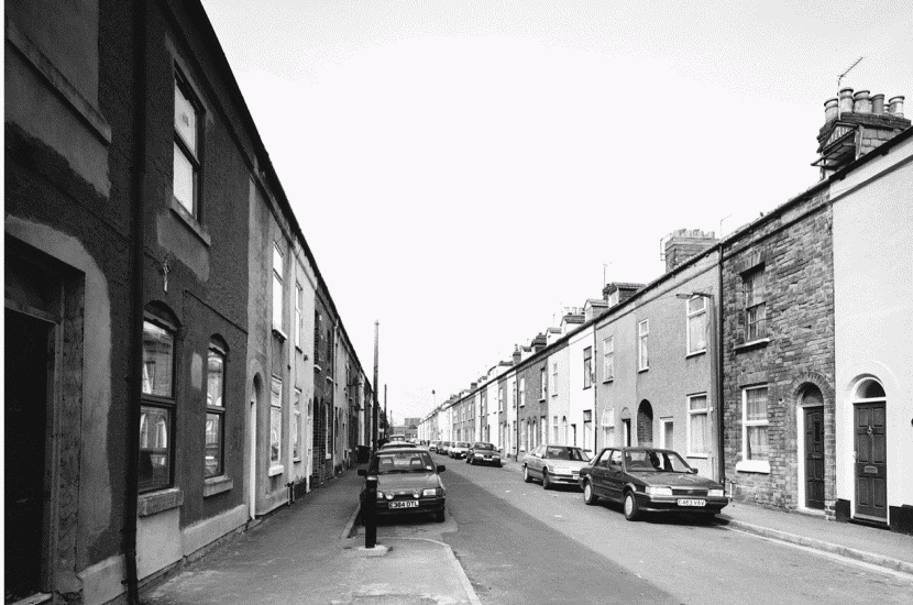
Terraced houses of later 1860s in Napier Street from south-west
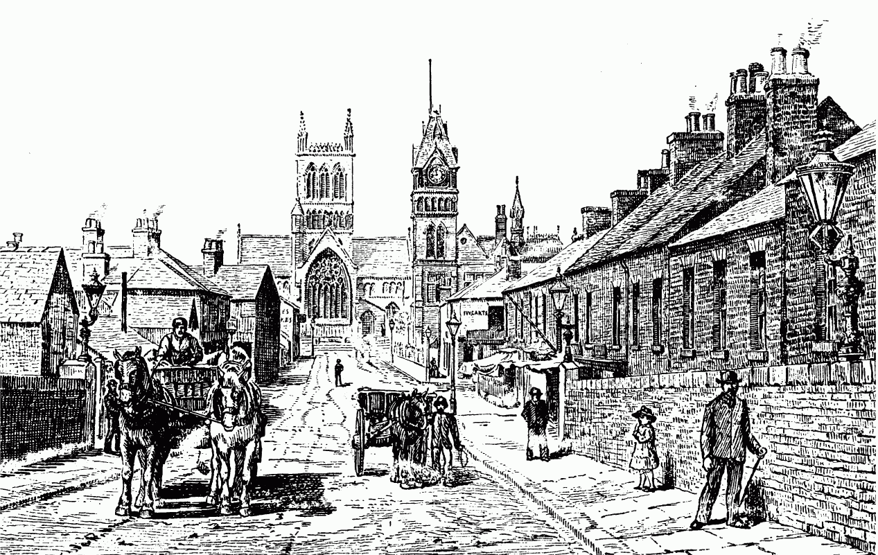
St. Paul's Square St. Paul's Square, west of the railway station, was laid out around St. Paul's church, built on a lavish scale in 1874 by the brewer Michael Thomas Bass. (fn. 2k) Four large houses on the south side of the square had already been built by 1871, (fn. 3j) and further doublefronted, two- and three-storeyed detached brick houses were built around the church, along with some semidetached and terraced houses in side streets. Bass also provided an imposing institute on the north-east side of the square, enlarged when it became the town hall in 1894. (fn. 4j) It was then proposed to demolish the terraced houses in St. Paul's Street East and open out the area in front of the town hall, but nothing was done until after Edward VII's visit in 1902: King Edward Place was duly laid out in 1906. (fn. 5i) A bronze statue of Lord Burton in front of the hall, sculpted by F. W. Pomeroy, was unveiled in 1911. (fn. 6h)
Although the development of Grange farm southwest of St. Paul's Square was being contemplated by the marquess of Anglesey by 1864, (fn. 7h) it was not until the 1870s that Grange Street and the east side of Shobnall Street were built up. (fn. 8g) The High Victorian Gothic almshouses at the north end of Wellington Street not far from the square were built in the early 1870s. (fn. 9g)
South of the Town Centre
Branston Road There was also extensive development in the later 19th century on the south side of the town, beyond the former Bond End canal. By 1857 there were a few houses on the west side of Branston Road, including Broadfield House south of the later Queen Street. (fn. 10f) There were also detached houses on the east side of the road by 1865; more were built in the 1870s, some with decorative barge boards and polychrome brickwork and one with a porte-cochère of the 1920s. Clarendon Terrace, at the corner with All Saints Road, is also of the 1870s and has French-Empire style towers at either end. (fn. 11e) Marking the rising status of the road, the Arts and Crafts Gothic-style All Saints' church was opened on its present site in 1905, its predecessor having been a humble building in All Saints Road. (fn. 12e)
West of Branston Road Queen Street had been built up as far as its junction with Uxbridge Street by 1865 (fn. 13d) and was later extended westwards, whilst Uxbridge Street itself was built up in the 1870s for its whole length as far as West Street (later All Saints Road); (fn. 14c) Wood Street existed by 1870, King Street and Broadway Street by 1879, (fn. 15c) and the north end of Oak Street by 1882. (fn. 16c) On the west side of Uxbridge Street houses were built in the later 1860s in Napier Street, Peel Street, and Clarence Street for Burton Building Society. Designed by Henry Worth of Sheffield, those in Napier Street are amongst the very few artisans' houses in Burton to have a notable architectural feature, albeit merely a band around the front door. (fn. 1l) A board school in Uxbridge Street was opened for the area in 1876, followed by an Anglican church in 1879 on a temporary site in West Street and a Methodist chapel in Queen Street in 1885. (fn. 2l)
Anglesey Road Anglesey Road which sweeps round from Evershed Way to Branston Road was developed from two short roads. The northern road existed as Sykes Street in 1882 and provided access to malthouses and an engineering works. Built up with houses by 1900, when it was called Kimmersitch Street, it had by then been joined up with the southern road, which led off Branston Road and was known as Varlow Street from at least 1891. The name Anglesey Road was adopted for the road's entire length some time between 1904 and 1908. (fn. 3k)
East of Branston Road The northern end of Blackpool Street, parallel to Branston Road and named after a stretch of water so called by the 12th century, (fn. 4k) was built up in the early 1880s. The rest of the street as far as Leicester Street had been completed by 1900. (fn. 5j) There were houses in Watson Street at the north end of Blackpool Street by 1882, and Burton's first council houses were built there in 1898. (fn. 6i)
The extreme southern end of Branston Road was transferred from Branston township to Burton borough in 1878. A row of cottages was built there c. 1880, and further rows had been built by 1891. (fn. 7i) The area was served by a mission church opened in St. Matthew's Street in 1886. (fn. 8h)
THE TWENTIETH CENTURY
New Housing and Slum Clearance
Between 1892 and 1908 the housing stock was increased by 2,809 houses, most of them built by private contractors in Horninglow, Uxbridge, and Victoria wards. (fn. 9h) They helped to relieve the problem of overcrowding which was reported by the borough surveyor in 1896, the worst areas then being courts and yards in New Street, Branston Road, Horninglow Street, and Wetmore Road. (fn. 10g) Public buildings replaced some of the poor housing: in New Street a fire station (1903) in a mid Georgian style with two storeys of red brick over an ashlar-faced ground floor, and a post office (1905) in an Edwardian Free-style with Flemish Baroque details, the two upper storeys being striped in brick and stone under three prominent gables; and in Horninglow Street the magistrates' court (1910), built of white artificial stone and designed by Henry Beck of Burton in a Continental Baroque style with a dome as its dominant feature. (fn. 11f)
Because of the decline in population there were 593 empty houses in the borough in 1910, and the medical officer of health reported no lack of suitable houses for artisans and labourers. (fn. 12f) House-to-house inspections carried out in the central wards between 1912 and 1914 noted only limited slum housing, mainly in the courts. (fn. 13e) In 1919 the council estimated that there was an immediate need for 100 working-class houses, and by 1922 it had provided most of them in Ash Street and Beech Street, off Anglesey Road, and in Mona Road, in Horninglow. (fn. 14d) Further council houses were built in the early 1930s in Anglesey Road itself and in Gordon Street, west of Waterloo Street, but most of the inter-war council housing was in Horninglow, Stapenhill, and Winshill.
A survey of housing conditions undertaken between 1946 and 1953 identified about 2 per cent of the county borough's total housing stock as unfit for human habitation, the highest concentration being in the Casey Lane area on the east side of Shobnall Street. It was not until the early 1960s, however, that a slum clearance programme was begun. (fn. 15d) Progress was slow, and the Casey Lane houses (in Charles, Henry, Thomas, and John Streets) were not demolished until 1970-1. (fn. 16d) New housing was then built in Grange Close and Shobnall Close, which mostly take the line of Charles Street, and houses on the west side of Shobnall Street and the east side of Grange Street also date mostly from the 1970s.
Council houses continued to be built in Stapenhill and Winshill after the Second World War, and from the 1960s there has been considerable private development, especially in Branston and Stretton.
Town-Centre Redevelopment
Following the laying out in 1922 of a garden of remembrance with a war memorial in the north-east corner of the former monastic precinct, (fn. 1m) the surviving parts of the abbey gatehouse were demolished in 1927, along with a row of shops, so opening up the market place. The space was filled in the early 1930s by the present Abbey shopping arcade. (fn. 2m)
Further shopping centres were opened from the 1960s as the clearance of breweries and other industrial premises in High Street and elsewhere in the town centre led to extensive redevelopment: (fn. 3l) the Riverside shopping centre at the north end of High Street on its east side (1964) and the first stage of the Burton shopping centre on the west side of the market place (1970). When the latter was extended in 1974, buildings along the east side of Union Street, including the public library, were demolished to make room for a carpark. Houses on the west side of Union Street were demolished in the later 1990s, along with parts of Bass's New Brewery; the land there is covered by a carpark for a Sainsbury supermarket, opened in 1997 with an eye-catching glazed tower at the Station Street corner. The east end of Park Street was blocked off when the Octagon shopping centre was opened on its north side in 1990, on the site of the former Thornewill & Warham ironworks. The centre's name is taken from the top-lit octagon on which the inside malls converge. The Watson Street council houses of Branston Road were demolished in 1995 to make way for a carpark for a Tesco supermarket.
After the demolition in 1994 of the Duke Street infirmary, the block of land bounded by Russell Street and Union Street was filled in with houses and flats in what is called Gough Side. (fn. 4l) Other town-centre housing developments include Ordish Court on the east side of Ordish Road, dating from the 1980s, and the Orchard Street estate on the north side of Park Street, built in the late 1980s and including a block of flats called the Willows added by Orbit housing association in 1991. (fn. 5k) Two blocks of flats called James Court at the east end of James Street were opened in 1993 by Burton Y.M.C.A. for young single people. (fn. 6j)
The market place and parts of High Street and Station Street were pedestrianised in the 1990s and remain the town's retail centre. Moreover, the removal of the High Street breweries has once more enabled public access to the Hay, where the pleasant riverside meadows restore the Trent as Burton's most distinctive natural feature.