A History of the County of Stafford: Volume 9, Burton-Upon-Trent. Originally published by Victoria County History, London, 2003.
This free content was digitised by double rekeying. All rights reserved.
'Stapenhill: Introduction', in A History of the County of Stafford: Volume 9, Burton-Upon-Trent, ed. Nigel J Tringham (London, 2003), British History Online https://www.british-history.ac.uk/vch/staffs/vol9/pp207-211 [accessed 3 May 2025].
'Stapenhill: Introduction', in A History of the County of Stafford: Volume 9, Burton-Upon-Trent. Edited by Nigel J Tringham (London, 2003), British History Online, accessed May 3, 2025, https://www.british-history.ac.uk/vch/staffs/vol9/pp207-211.
"Stapenhill: Introduction". A History of the County of Stafford: Volume 9, Burton-Upon-Trent. Ed. Nigel J Tringham (London, 2003), British History Online. Web. 3 May 2025. https://www.british-history.ac.uk/vch/staffs/vol9/pp207-211.
In this section
Introduction
Lying on what was formerly the Derbyshire side of the river Trent, Stapenhill was a large parish with a church which may have had minster status in the Anglo-Saxon period.
The parish comprised three townships, the main one also called Stapenhill and treated in this article. (fn. 1) Burton abbey was a major landholder in Stapenhill township and its tenants were deemed to be in Burton parish. In the 19th century Stapenhill village greatly expanded to become a mainly middle-class suburb of Burton; working-class houses were also built for local brickworkers. There has been considerable 20th-century housing development, much of it council-built for tenants moved out of Burton town centre.
Stapenhill township covered 1,647 a. (666.5 ha.). Its southern boundary followed a stream called Ryle brook in 1488. (fn. 2) The north-western part of the township, covering 769 a. (310.2 ha.) and stretching down to the Burton-Leicester branch railway line, was taken into Burton municipal borough on its extension in 1878, (fn. 3) and under the Local Government Act of 1888 that area, then given as 811 a. (328.2 ha.), was treated for municipal purposes as part of Staffordshire. (fn. 4) It was wholly transferred to Staffordshire in 1894, when the rest of the township was added to adjoining Derbyshire civil parishes: the north-eastern part around Brizlincote Hall Farm to Bretby civil parish and the southern part around Drakelowe House to Drakelow. (fn. 5)
The acreage of the Stapenhill ward of Burton county borough was 790 a. in 1921, and under a boundary change of 1934 it gained 16 a. from Bretby. (fn. 6) In 1979 two new wards, Edgehill and Waterside, were created out of the southern part of Stapenhill ward together with land taken from Winshill ward. (fn. 7) The three wards jointly covered 1,008 a. (408 ha.), increased to 1,097 a. (444 ha.) after a boundary change of 1991 which added farmland on the eastern boundary from Bretby. (fn. 8)
The underlying rock is sandstone with some marl, overlain with patches of boulder clay in the north-east of the township along Ashby Road and further south on the east side of Stanton Road. The soil is a loamy soil. (fn. 9) The land rises from 147 ft. (45 m.) beside the river in Stapenhill Hollows to 400 ft. (122 m.) on the northern boundary. The intervening Scalpcliff hill rises to 335 ft. (102 m.). Its top is particularly level above the 300 ft. (91.5 m.) contour: the name, first recorded in the later 12th century, is derived from the Scandinavian word for a shelf (skjalf), either as the original element or replacing a similar Old English word. (fn. 10) Beyond the valley of Brizlincote brook, which flows, mostly culverted now, through the centre of the township, the land again rises to the east and south-east, reaching just over 300 ft. (91.5 m.) at Brizlincote Hall Farm.
POPULATION
The adult population listed in an Easter Book for Burton parish probably of the 1550s was 98, a figure that presumably included only those who lived in the Burton parish part of the township. (fn. 11) An ecclesiastical return for Stapenhill parish in 1563 recorded 31 households in the townships of Stapenhill and Stanton with Newhall. (fn. 12) The population of Stapenhill township alone was 457 in 1811, falling to 447 by 1821 but rising steadily to 535 by 1821, 577 by 1841, and 635 by 1851. Thereafter the rises were more substantial, reaching 1,111 by 1861, 1,967 by 1871, 3,843 by 1881, and 4,703 by 1891. (fn. 13) The most populated part of the township was included in Burton municipal borough in 1878, with only 65 people living in the non-Burton part in 1891. (fn. 14) The population of the Burton part was 5,771 in 1901, falling to 5,234 by 1911 and 5,228 by 1921 but then rising to 5,740 by 1931. After the Second World War Stapenhill became the most populous part of Burton borough: in 1951 its population was 8,992, rising to 10,419 by 1961, 11,765 by 1971, 13,229 by 1981, and 13,888 by 1991. (fn. 15)
COMMUNICATIONS
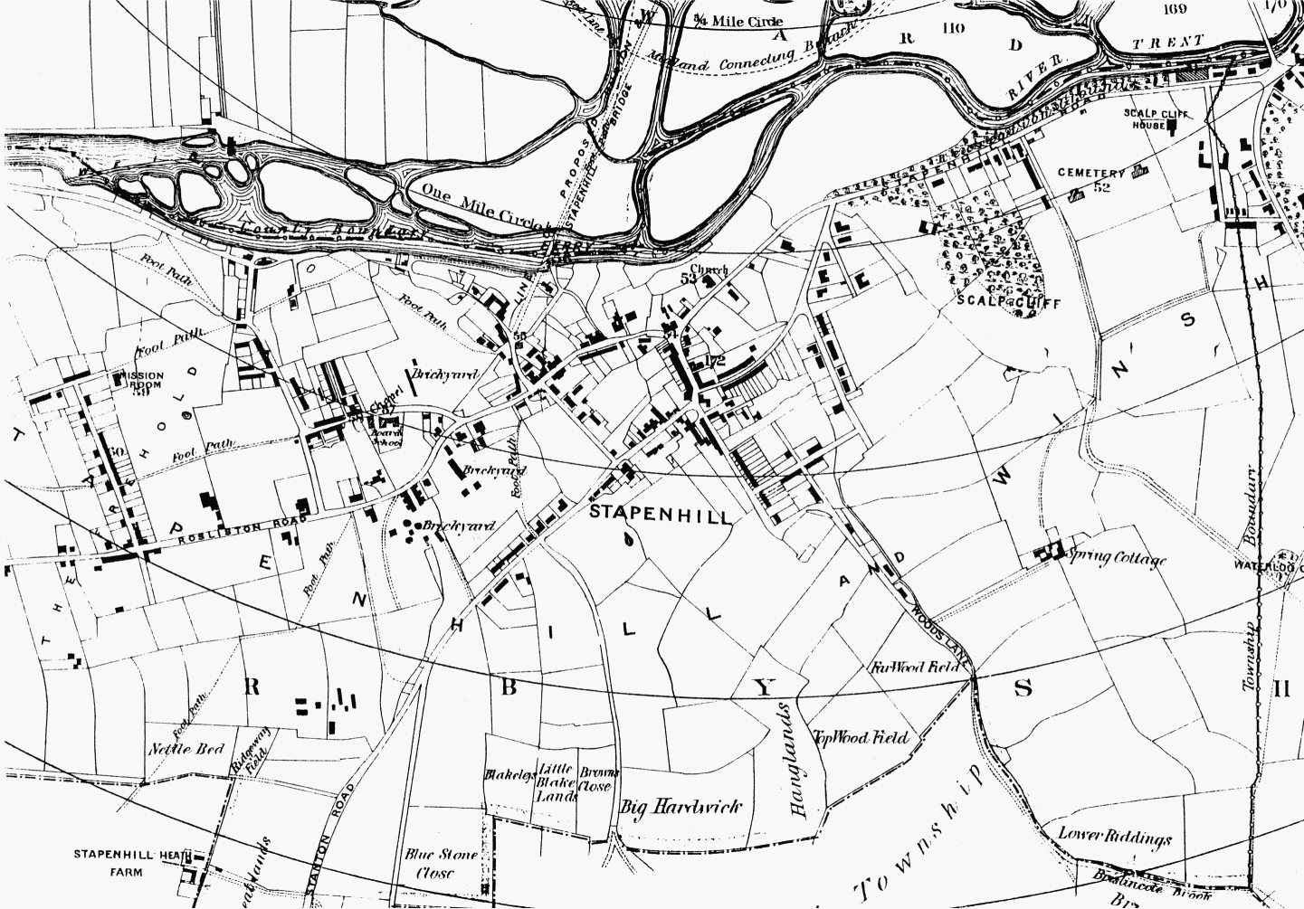
Main Roads A road called the portway in the mid 13th century ran south from Burton bridge under Scalpcliff hill. (fn. 1a) It divided at Stapenhill village, one arm (the present Rosliston Road) leading south to Cauldwell and then on to Tamworth, and the other (Stanton Road) leading south-east to Stanton and then on to Nuneaton (Warws.). The Cauldwell road was taken over Ryle brook by a bridge first mentioned in the early 18th century. By the later 18th century what was called Mare Yard bridge further west along the stream carried a road to Drakelow. (fn. 2a) The Stanton road was turnpiked in 18th century as part of a route from Measham (Derb.), and by 1825 there was a tollgate a short distance north of the church. It stood further north beside Elms Road by 1864, and was removed after the road was disturnpiked later in the century. (fn. 3a) Railway The branch railway line from Burton to Leicester, which forms the southern boundary of the Burton part of Stapenhill, was opened in 1849. (fn. 1b)

Stapenhill township and village
SETTLEMENT
Roman and Anglo-Saxon Periods A small square enclosure excavated on the west side of Stanton Road was almost certainly a Romano-British settlement which survived into the 4th century. (fn. 2b) A coin of A.D. 327 was found in 1881 on an adjacent site, which was later used as a cemetery by the first Anglo-Saxons. Most of the burials were inhumation with grave goods, indicating a pre-Christian origin. (fn. 3b) A cruciform brooch, decorated with a garnet and found nearby at Brizlincote in 1850, probably dates from the late 6th or early 7th century. (fn. 4a)
Stapenhill Village The Old English name Stapenhill means steep hill, probably the small hill on which the parish church stands. There was almost certainly a church, possibly of minster status and on the present site, in the Anglo-Saxon period. (fn. 5a) The medieval village developed near by around a green whose remnant survives at the junction of Main Street and Stapenhill Road, and where a small sandstone cross is a memorial to those who died in the First and Second World Wars.
Some of the present brick-fronted houses in Main Street may date from the 17th century but the most substantial house, Stapenhill House, was demolished in the early 1930s and a pleasure ground laid out over the site. (fn. 6a) Dating from the 16th century or earlier, Stapenhill House was built on an H-plan of brick with stone dressings around the windows (fn. 7a) and it was presumably the house assessed for tax on nine hearths in 1662. There was a number of other large houses in the village at that date, two assessed on six hearths and another two on five. (fn. 8a)
Waterside There were also houses in the later 18th century south-west of the village along Ferry Street, which led to a small riverside settlement at Waterside, so called in the late 1590s and probably associated with the medieval ferry. The mainly 18th-century Ferry House there possibly stands on the site of the cottage which the ferryman was licensed to build in 1596. The nearby brick house called Ferry Cottage, dated 1889, was presumably built for the toll-collector for the foot bridge which replaced the ferry that year. (fn. 9a)
19th-Century Development The still rural character of Stapenhill village was depicted in the 1840s by the Lake District artist John Harden, whose daughter was married to John Clay, the vicar of Stapenhill. (fn. 10a) It was soon to be transformed, however, into a suburb of Burton with several large detached houses (later demolished) as well as terraces of middle-class housing. Already by 1845 Bridge End Farm at the north end of Stapenhill Road had been renamed Scalpcliff House, (fn. 11a) and in 1852 some of the farmland along Stapenhill Road and Scalpcliff Road was surveyed for use as building plots; the rest of the farmland was acquired by Burton corporation for a municipal cemetery, opened in 1866. (fn. 12a)
Semi-detached villas and rows in Clay Street and Malvern Street off the east side of Stapenhill Road date mostly from the 1870s. They may have been among the houses built on the edge of Stapenhill village after the marquess of Anglesey exchanged land there despite the warning of his Burton agent, who in 1863 argued that its value might increase if a bridge was built over the river from the south end of Burton, as one was in 1889. (fn. 13a)
The detached houses included the Heath, occupied by Mrs. Ann Bass in 1846 and probably the 'handsome mansion' called Heath Cottage in 1857. (fn. 14a) Albury House set in grounds off the east side of Stapenhill Road was built probably in the late 1860s for the Burton brewer and M.P., Sydney Evershed (d. 1903), and was named after his birthplace in Surrey. (fn. 15a) Park Hill House on the high ground on the west side of Rosliston Road had been built by 1870 for Josiah Poyser, a brewer, and another large house called the Heath to the north was built probably about the same time for Robert Belcher, a surgeon, the occupier in 1881. (fn. 16)
In contrast, the development of brickworks in the southern part of the township especially from the 1840s led to the construction of artisans' houses, the earliest probably dating from the 1850s in Hill Street (together with a court named Pickering Street off its west side) and at the west end of Heath Road. Long Street and the southern end of Short Street were also built up probably in the 1850s, possibly by the Burton Freehold Land Society, as at Winshill: the streets stood on land called the Freehold in 1879. (fn. 1c) Methodist chapels were built for the area in 1855 and 1866, and an Anglican mission room was opened in Short Street in 1869. (fn. 2c)
Stapenhill in 1879
Several 19th-century houses have been converted into nursing homes, notably one at the south end of Main Street, opened as the Croft in 1987. (fn. 3c) Albury House was sold to Staffordshire county council in 1956 for conversion to a nursing home, but it proved unsuitable and was demolished. Rider House, a purpose-built home named after Alderman George Rider, mayor 1941-2, was opened by the county council in the grounds in 1961. It was privatised in 1992. (fn. 4b)
20th-Century Housing Estates In the mid 1920s council houses were built in two new streets off Rosliston Road, Baker Street (on the west side) and Saxon Street (on the east side), and in 1929 in the northern extension of Short Street between Heath Road and Baker Street. A large council estate stretching westwards from Rosliston Road to the river was built in two stages: as far as Somerset Road in 1939 and the rest (including Cumberland Road) in the later 1940s. Another council estate covering the northern half of Sycamore Road off the west side of Stanton Road dates from the mid 1950s, and private houses between Rosliston and Sycamore Roads date from the same period. An Anglican church was opened for the area in 1963. (fn. 5b) The Sycamore Road council estate was extended southwards in the mid 1960s. Violet Way, running off the east side of Stanton Road, and its continuation, Beaufort Road, were laid out with private houses from the early 1980s.
Sheltered housing called Vicarage Field on the north side of the former vicarage house near the church was opened by the Anchor housing association in 1979. (fn. 6b)
Outlying Areas There was a settlement at Brizlincote by the early 12th century, its name possibly meaning a cottage in an enclosure. It became the centre of an estate later in the Middle Ages, and there may have been a chapel there. The present Brizlincote Hall Farm dates from the early 18th century. (fn. 1d)
Drakelowe House in the part of the township added to Drakelow in 1894 had been built by 1882, possibly for a lawyer, William Drewery, the occupier in 1891. (fn. 2d)
Services Although the built-up part of Stapenhill was taken into Burton borough in 1878, it was not until the early 20th century that it fully benefited from a mains water supply and sewerage system. (fn. 3d)
SOCIAL LIFE
Societies and Social Clubs
A friendly society which met at the Barley Mow in Main Street was registered in 1854. Lodges of Oddfellows were established in 1866 (Manchester Unity) and 1874 (United Order), and the former survived until 1990 when it was amalgamated with the newlyformed Trent Lodge in Burton. (fn. 4c)
The Trisantona Lodge of Freemasons, consecrated at Stapenhill Institute in 1919, moved in 1933 to Ashfield House, the newly-opened masonic hall in Winshill. (fn. 5c)
Stapenhill Institute was opened in temporary premises in Ferry Street in 1884. It was rehoused in 1888 in a new building of red brick in Main Street, still open as a social club in 1999. (fn. 6c)
Waterside House in Waterside Road, of brick in a Queen Anne style with a curved bay and dating from the 1890s, was opened as a community centre by Burton corporation in 1947. (fn. 7b) Since 1986 it has been run by Staffordshire county council as a day centre for people with learning difficulties. (fn. 8b)
In 1968 the Stapenhill branch of Burton Labour Party opened a social club on the site of a disused Methodist chapel in Long Street. It was named the Red Rose Club in the early 1990s. (fn. 9b)
Recreation Grounds
By 1857 a strip of land along the riverbank near the present municipal cemetery had been laid out by Edward Cliff, a beerhouse keeper, as a public pleasure ground. It was taken over by the Burton improvement commissioners in 1865, (fn. 10b) and bandstands and arbours were erected there by Burton brewers in the 1870s. (fn. 11b) Its southern end opens on to Stapenhill Hollows (formerly open meadow called Church meadow), and the whole area has become part of the Washlands nature reserve. The 4-a. recreation ground on the south side of Heath Road was opened by Burton corporation in 1894, and Waterside Community Centre was built there in 1989. (fn. 12b)
In 1933 Henry Goodger gave the land adjoining the former Stapenhill House and part of its garden as a pleasure ground in memory of his mother. (fn. 13b) The central portion of the ground was lost when the access road for St. Peter's bridge was laid out in 1985.
The Sycamore Road housing estate is served by a small recreation ground, lying north of the football ground and called Edgehill community park by 1999.
Sports Clubs
Burton golf club was established in 1894 with links in Stapenhill, probably on the north side of Woods Lane. The club moved to Branston in 1897, and later to Bretby (Derb.). (fn. 14b)
The present Stapenhill football club was formed in 1947, and since 1955 it has played on a ground beside the railway line off Sycamore Road, just inside Derbyshire. (fn. 15b)
Two rowing clubs have boathouses on the Stapenhill side of the river near Burton bridge. (fn. 16a)