An Inventory of the Historical Monuments in the County of Northamptonshire, Volume 1, Archaeological Sites in North-East Northamptonshire. Originally published by Her Majesty's Stationery Office, London, 1975.
This free content was digitised by double rekeying. All rights reserved.
'Irthlingborough', in An Inventory of the Historical Monuments in the County of Northamptonshire, Volume 1, Archaeological Sites in North-East Northamptonshire, (London, 1975) pp. 56-58. British History Online https://www.british-history.ac.uk/rchme/northants/vol1/pp56-58 [accessed 12 April 2024]
27 IRTHLINGBOROUGH
(OS 1:10000 a SP 97 SW, b SP 97 SE, c SP 96 NW)
The parish, covering 1230 hectares, lies W. of the R. Nene on land rising westwards between 120 ft. and 300 ft. above OD. The higher W. and N.W. part is on Boulder Clay but along the river, sands, clays and limestones outcrop in broad bands. Until 1972 very little of the Roman period had been found in the parish, but subsequently intensive fieldwork has enabled a number of settlements (5–12) to be listed.
Prehistoric and Roman
(1–4) comprises a series of mounds on the edge of the R. Nene. They have been interpreted as barrows but this is unproven. In the Northampton Museum is an account of the discovery in this area of an Overhanging Rim Urn which has since been lost. No other details.
b(1) Mound (SP 96387162), on alluvium in the flood-plain of the R. Nene, at 120 ft. above OD. Circular, diam. 28 m., height 1 m. No trace of a ditch.
b(2) Mound (SP 96637143), 300 m. S.E. of (1) and in a similar position. Circular, 35 m. in diam., height 2 m. The N.W. side has been cut away by the railway which was built in 1847.
b(3) Mound (SP 958712), on gravel, at 120 ft. above OD. Diam. 30 m., height 0.5 m., with traces of a ditch. (Beds. Arch. J., 7 (1972), 14, Irthlingborough 7)
b(4) Mound (SP 966715) in a similar position to (3). Diam. 30 m., height 0.5 m. (Beds. Arch. J., 7 (1972), 14, Irthlingborough 9)
a(5) Iron Age and Roman settlement (?) (SP 946712), on the N. side of a small valley, on limestone, 220 ft. above OD. Ditches containing late Iron Age pottery were discovered during building work on the site (Beds. Arch. J., 3 (1966), 5; 4 (1969), 1–2). Subsequent excavations revealed a complex of intersecting small curving ditches, apparently parts of hut circles. Roman features including ditches and a corn-drying oven were also found. (Beds. Arch. J., 7 (1972), 17–20)
a(6) Iron Age settlement (?) (SP 942694), on the N. side of the R. Nene, on gravel, at 165 ft. above OD. Iron Age pottery of early date has been found within an area of dark soil and pebbles (BNFAS, 7 (1972), 4).
b(7) Iron Age and Roman settlement (SP 958715), on a low spur, overlooking the R. Nene, on limestone, at 225 ft. above OD. Large amounts of early and late Iron Age and Roman pottery have been found (BNFAS, 7 (1972), 4; Beds. Arch. J., 7 (1972), 14, Irthlingborough 5). The 'traces of ploughed out ramparts' reported here are merely the high terminations of medieval ridge-and-furrow, now ploughed down, around two sides of the spur (RAF VAP CPE/UK 1925, 3253–4).
c(8) Roman settlement (SP 943694) lies on the N. side of the R. Nene, on gravel, at 160 ft. above OD. A scatter of building-stone, Roman pottery and some coins have been found; other finds include barbed-and-tanged, and leaf-shaped, arrowheads as well as two polished stone axes (OS Record Cards; BNFAS, 7 (1972), 21).
c(9) Roman settlement (SP 940693), in a similar position to (7) and slightly to its S.W. A scatter of Roman pottery and building-stone has been found. Part of the settlement has probably been destroyed by the adjacent ironstone workings (BNFAS, 7 (1972), 21; Beds. Arch. J., 7 (1972), 14, Irthlingborough 3).
c(10) Roman settlement (SP 945696), in a similar position to (8) and a little to the N.E. A scatter of Roman pottery and occupation debris has been found (BNFAS, 7 (1972), 21). The site has subsequently been described as a building (Beds. Arch. J., 17 (1972), 14, Irthlingborough 13).
a(11) Roman settlement (?) (SP 944715), N. of the town on clay at 250 ft. above OD. Roman pottery, including Nene Valley types, and part of a quern stone, all associated with an area of dark soil, have been found (BNFAS, 7 (1972), 21).
b(12) Roman settlement (SP 95107070) was discovered during excavation of All Saints' Church (15) in 1965. The site lies close to the R. Nene on clay at 125 ft. above OD. Although no Roman material was found in situ during the excavation, large quantities of pottery, tegulae and tesserae were discovered as well as a piece of floor tile. There are also records of considerable amounts of Roman pottery being found in the area. A Roman settlement of some size is indicated. Iron Age pottery has also been found nearby. (Beds. Arch. J., 7 (1972), 14, Irthlingborough 6; BNFAS, 8 (1973), 4; see also Northants. Ant. Soc. Rep., LXV (1966), 16–18)
(13) Roman settlement (?) (unlocated). Many fragments of Roman pottery are said to have been found around Irthlingborough (T. J. George, Arch. Survey of Northants., (1904), 16). There are also records of Roman brick and much pottery from 'near Tanberdyke Hedge' (J. Cole, Hist. and Ants. of Higham Ferrers (1838), 230).
For Roman Road 570, see p. 116.
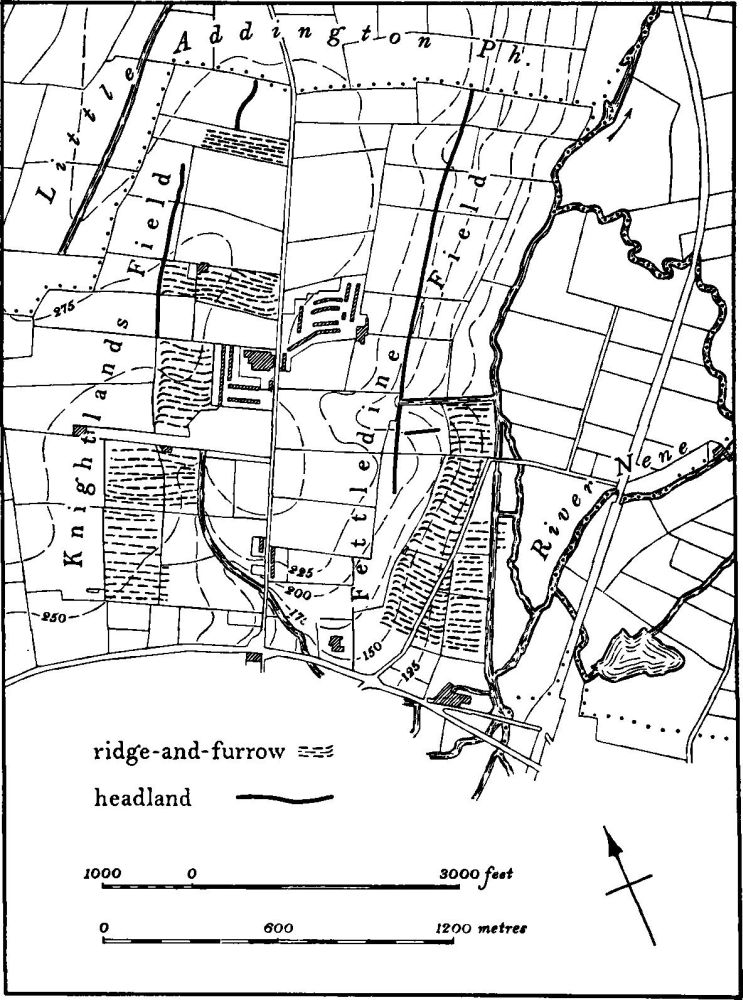
Fig. 69 Irthlingborough (16) Medieval cultivation remains
Medieval and Later
b(15) Site of All Saints' Church and manorial complex (SP 95107070) lies N.E. of the town, near the R. Nene. The church was one of two in Irthlingborough, but as early as 1428 it has only eight parishioners. Apparently in regular use in the early 16th century, by 1562 it was described as 'devastated and in utter ruin' and in the 17th century it was pulled down. Excavations on the site in 1965 revealed the whole plan of the building, and four separate phases of construction starting with a 12th-century structure, were recognized. Some 400 skeletons were also excavated.
The site is still surrounded by indeterminate earthworks which are all that remain of a large manorial complex including building sites and fishponds, now largely destroyed. (Northants. Ant. Soc. Rep., LXV (1966), 3–18; RAF VAP CPE/UK 1925, 2253–4)
(16) Cultivation remains (Fig. 69). The common fields of the parish were enclosed by Act of Parliament of 1808 (see also NRO, Map of 1801). Before that date there were six common fields but the land occupied by one West Field, is now in Wellingborough parish. Ridge-and-furrow of these fields exists on the ground, or can be traced on air photographs, in a number of places. It is all arranged in end-on furlongs, mostly of reversed-S shape. That N. of the town (SP 932716 and 940715) lay in Holbush Field, N.W. of the town (SP 938711 and 938702) in Up Windmill Field and N.E. of the town (SP 942714 and 948718) in Knightland Field. Further indistinct traces of similar ridge-and-furrow S. of the town (SP 937694 and 942691) lay in Broadham Field. To the E. of Irthlingborough (SP 956713) are other traces formerly in Fettledine Field while to the N. (SP 962723), a well-marked ridge, 30 m. wide and almost 1 km. long, is a former headland between end-on furlongs (RAF VAP CPE/UK 1925, 2249–54, 3248–56, 4249–55; 1924, 2394–7; 540/474 3026. 3034–40)