An Inventory of the Historical Monuments in the County of Northamptonshire, Volume 2, Archaeological Sites in Central Northamptonshire. Originally published by Her Majesty's Stationery Office, London, 1979.
This free content was digitised by double rekeying. All rights reserved.
'Wollaston', in An Inventory of the Historical Monuments in the County of Northamptonshire, Volume 2, Archaeological Sites in Central Northamptonshire(London, 1979), British History Online https://www.british-history.ac.uk/rchme/northants/vol2/pp176-182 [accessed 9 May 2025].
'Wollaston', in An Inventory of the Historical Monuments in the County of Northamptonshire, Volume 2, Archaeological Sites in Central Northamptonshire(London, 1979), British History Online, accessed May 9, 2025, https://www.british-history.ac.uk/rchme/northants/vol2/pp176-182.
"Wollaston". An Inventory of the Historical Monuments in the County of Northamptonshire, Volume 2, Archaeological Sites in Central Northamptonshire. (London, 1979), British History Online. Web. 9 May 2025. https://www.british-history.ac.uk/rchme/northants/vol2/pp176-182.
In this section
66 WOLLASTON
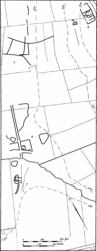
Fig. 156 Wollaston (4) Roman settlement, (3, 6, 7) Cropmarks
(OS 1:10000 a SP 86 SE, b SP 96 SW)
The parish, covering around 1145 hectares, lies S. of Wellingborough between the R. Nene which forms its N.W. boundary and Bedfordshire which lies to the E. The E. part is mainly covered by Boulder Clay and slopes gently W. between 90 m. and 100 m. above OD. To the W. the land falls dramatically across a steep slope along which limestones, sands and silts are exposed to a generally flat area between 45 m. and 60 m. above OD, partly floored by clay but with extensive areas of river gravel and alluvium near the Nene. The parish is notable for the large number of prehistoric and Roman sites. The most impressive are those revealed by air photography on the limestone and gravel, but there are also many settlements on the higher Boulder Clay, most of which have been discovered by field-walking.
Prehistoric and Roman
A polished stone axe has been found within the village (SP 907627; Beds. Arch. J., 7 (1972), 96–7).
a(1) Ring Ditch (SP 89536468), in the N.W. of the parish, on alluvium at 40 m. above OD. Air photographs (in NMR) show a ring ditch 30 m. in diam. (BNFAS, 6 (1971), 18, Wollaston (2)).
b(2) Roman Villa and Enclosures (SP 901650; Fig. 85), in the N.W. of the parish, on clay and alluvium at 43 m. above OD. Air photographs (CUAP, ABD 94, AFX 4, ZE 69, 72–3, ZJ 82) show a small corridor villa with most of the internal walls still visible. Immediately to the S.E. a series of circular structures is also visible, while to the S.W. (at SP 900649) an extremely complex area of enclosures and other features can be seen. From the site of the villa have come limestone blocks, red and white tesserae, brick and roof and flue tiles, as well as much Roman pottery, including samian, painted wall-plaster, three coins, a small bronze bell, an iron lock, pieces of baked clay, perhaps kiln bars, a few worked flints and black hand-made pottery, probably of Iron Age date (JRS, 51 (1961), 134; Beds. Arch. J., 3 (1966), 6; BNFAS, 6 (1971), 18, Wollaston (1); 7 (1972), 38; NM). A leaf-shaped arrowhead (NM) has been found in the field to the S.
a(3) Enclosure, Ditches and Pit Alignments (SP 899644; Fig. 156), 400 m. S. of (2), on gravel at 46 m. above OD. Air photographs (CUAP, ZE 74) show a large, sub-rectangular enclosure with associated linear ditches. On the E. one of the ditches intersects a pit alignment.
b(4) Roman Settlement (SP 904645; Fig. 156), 350 m. E. of (3) and immediately E. of Vicarage Farm, on sand at 62 m. above OD. Air photographs (CUAP, ZE 75–7, ZJ 80, and in NMR) show a rectangular ditched enclosure divided into a number of internal compartments. There are also indications of another enclosure attached to the N. side. Fragments of two penannular ditches within the main enclosure may represent hut-sites. Further S. there are two intersecting linear ditches. A few pieces of Roman pottery and limestone have been found (OS Record Cards).
b(5) Roman Settlement and Cropmarks (centred SP 908645; Fig. 157), immediately E. of (4), on limestone at 68 m. above OD. Air photographs (in NMR) show the remains of what may have been a ditched trackway, now largely destroyed by ironstonemining, running E.—W., with a sub-rectangular enclosure and other ditches lying to the S. Near the E. end of the trackway (at SP 911644) Roman pottery associated with a patch of charcoal and burnt pebbles has been found (Beds. Arch. J., 3 (1966), 6).
a(6) Ditched Trackway and Enclosures (SP 896640; Fig. 156), on the N. side of a small, N.W.flowing stream, on gravel at 44 m. above OD. Air photographs (in NMR) show a ditched trackway with an enclosure at its S. end. The latter has a number of internal features, including at least two penannular or ring ditches, probably hut-circles. Two other subrectangular enclosures and an irregular linear ditch are also visible in the area (BNFAS, 6 (1971), 18, Wollaston (3); Beds. Arch. J., 3 (1966), 6).
a(7) Settlement and Pit Alignments (SP 89556382; Fig. 156), immediately S. of (6), on the opposite side of the stream, on alluvium at 45 m. above OD. Air photographs (in NMR) show a compact group of small enclosures, with a possible ditched trackway approaching from the S.W. Two intersecting pit alignments lie immediately to the E. and another isolated enclosure to the N. (BNFAS, 6 (1971), 18, Wollaston (4)).
b(8) Iron Age and Roman Settlement (centred SP 905635; Fig. 158), on the N. side of the village, on limestone at 68 m. above OD. At SP 90456360, air photographs (in NMR) show an indeterminate series of linear ditches which can be traced N.W. to SP 90256385. On each side there is a small enclosure. Ditches containing Iron Age pottery and much Roman pottery and occupation debris have been found (Beds. Arch. J., 3 (1966), 6; 7 (1972), 16, Wollaston (16)). Further E. (at SP 90796344) a mid 4th-century coin is recorded (OS Record Cards).
b(9) Iron Age Settlement (SP 909641; Fig. 157), on limestone at 82 m. above OD. An early Iron Age enclosure, covering about two hectares and bounded by a shallow ditch, was partly destroyed during ironstone-mining. It contained four circles of post-holes. Outside the enclosure were more post-holes, probably of a rectangular building (Beds. Arch. J., 5 (1970), 113–4; 7 (1972), 16, Wollaston (17)).
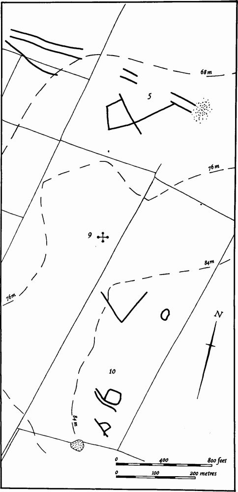
Fig. 157 Wollaston (5) Roman settlement and cropmarks, (9) Iron Age settlement, (10) Cropmarks
b(10) Ditched Trackway and Enclosures (centred SP 910637; Fig. 157), N. of the village, on Great Oolite Limestone at 84 m. above OD. Air photographs (RAF VAP F21 540/RAF/1312, 0294–5) show a short length of ditched trackway, with a rectangular enclosure attached to its S.E. end. Immediately to the S. is a small D-shaped enclosure, while further N. is an L-shaped ditch with an oval enclosure to its E.
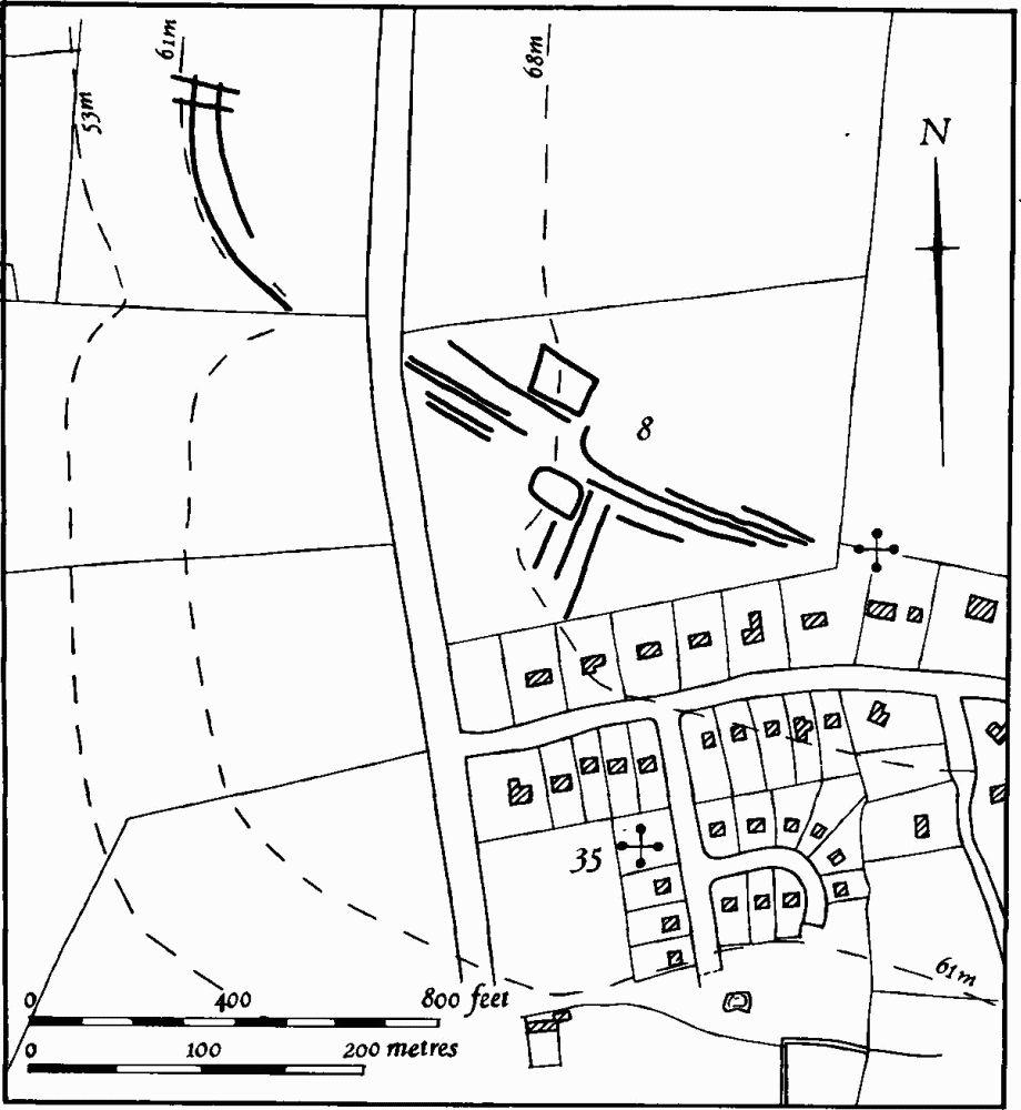
Fig. 158 Wollaston (8) Iron Age and Roman settlement, (35) Medieval occupation site
b(11) Enclosures, Ditches and Pit Alignment (SP 88676350; Fig. 159), in the W. of the parish, on gravel at 44 m. above OD. Air photographs (CUAP, ZE 42–3, and in NMR) show a double-ditched rectangular enclosure with a third, intermediate ditch on the N.E. side and a well-marked inner ditch. To the N.W. traces of a short length of ditched trackway are visible (Beds. Arch. J., 3 (1966), 6; BNFAS, 6 (1971), 18, Wollaston (5)). Immediately N.E. of the enclosure there is a group of conjoined rectangular enclosures on either side of a linear ditch, the whole bisected by a possible pit alignment (not shown on Fig. 159) which is very indistinct on all available air photographs.
a(12) Roman Settlement (centred SP 887632; Fig. 159), N.W. of Cringle House and immediately S. of (11), on gravel at 45 m. above OD. Air photographs (CUAP, BFQ 93, and in NMR) show a complex of ditched enclosures of various sizes with interior features and a number of linear ditches. A little to the N.E. (at SP 889633) Roman pottery and building-stone have been found (Beds. Arch. J., 3 (1966), 6).
a(13) Roman Settlement (?) (SP 886630; Fig. 159), 250 m. S.W. of (12), on gravel at 48 m. above OD. Roman pottery has been found, perhaps relating either to (12) or to (23) (Beds. Arch. J., 3 (1966), 6).
a(14) Roman Settlement (SP 892632; Fig. 159), on Boulder Clay at 50 m. above OD. A scatter of Roman pottery and building-stone has been discovered (Beds. Arch. J., 3 (1966), 6).
a(15) Roman Settlement (SP 894632; Fig. 159), 200 m. E. of (14), on clay at 52 m. above OD. Roman pottery and building-stone have been found (Beds. Arch. J., 3 (1966), 6).
a(16) Roman Pottery (SP 894635) reported midway between (7) and (15), on gravel at 48 m. above OD. A small number of Roman sherds have been found (Beds. Arch. J., 3 (1966), 6).
b(17) Iron Age Settlement (SP 913630), immediately E. of the village, on gravel at 91 m. above OD. Several pits and ditches have been found, containing Iron Age pottery (Beds. Arch. J., 5 (1970), 123; 7 (1972), 16, Wollaston (18)).
b(18) Iron Age Settlement (SP 916628), 300 m. S.E. of (17), on Boulder Clay at 91 m. above OD. A small early Iron Age hut-circle ditch, 5.3 m. in diam., was revealed in a pipeline trench (Beds. Arch. J., 7 (1972), 16, Wollaston (19)).
a(19) Enclosures and Ditches (SP 880629; Fig. 159), in the W. of the parish, on gravel at 44 m. above OD. Air photographs (in NMR) show what appears to be the S.W. part of a rectangular enclosure with markedly straight sides and a number of indeterminate interior features. The enclosure is intersected by several linear ditches, one of which extends S.W. to meet another, but more irregular enclosure. The latter has two ring ditches or hut-circles intersecting its S.E. side.
a(20) Iron Age Pottery (SP 882625; Fig. 159), in the W. of the parish, on gravel at 45 m. above OD. A few sherds of Iron Age pottery have been found. They may relate to the large site 200 m. to the S. (Grendon (7)).
a(21) Enclosures, Ditches, Ditched TrackWay and Pit Alignments (centred SP 886628; Fig. 159), on gravel at 45 m. above OD. Air photographs (CUAP, ACA 83–5, BCJ 71, 78, ZE 46–7, 49–51, ZJ 76–7; RAF VAP F22 540/RAF/1312, 0291–2) show cropmarks of sub-rectangular enclosures covering an area of some 5 hectares. The most southerly of these are intersected by a ditched trackway and pit alignments, parallel and close together, and visible for 600 m. from SP 88186241 to 88656262. From this (at SP 88506270) another pit alignment is visible, running S.E. for 100 m. to SP 88676255 (Beds. Arch. J., 3 (1966), 6; BNFAS, 6 (1971), 19, Wollaston (7)).
a(22) Iron Age Settlement (SP 887626; Fig. 159), between (21) and (23), on gravel at 48 m. above OD. Late Iron Age pottery associated with dark areas of soil has been found (Beds. Arch. J., 3 (1966), 6).
a(23) Enclosures (SP 889626; Fig. 159), 200 m. S.S.W. of Cringle House, on clay at 52 m. above OD. Air photographs (in NMR) show two adjacent, roughly rectangular enclosures and associated ditches (Beds. Arch. J., 3 (1966), 6). Further N.W. other photographs (CUAP, BCJ 78) show a small sub-rectangular enclosure and a series of indeterminate ditches (SP 888628).
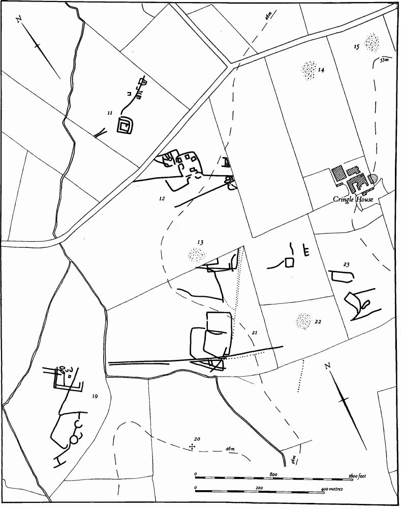
Fig. 159 Wollaston (11, 19, 21, 23) Cropmarks, (20, 22) Iron Age settlements, (12–15) Roman settlements
a(24) Iron Age and Roman Settlement (SP 897625; Fig. 124), W. of the village, on limestone at 60 m. above OD. Air photographs (CUAP, ZE 44–5) show a large rectangular enclosure containing various ditched features and intersected by other ditches. A group of small conjoined enclosures lies immediately to the N.E. A few sherds of Iron Age and Roman pottery have been found (Beds. Arch. J., 3 (1966), 6; OS Record Cards).
b(25) Roman Building (SP 90326254), S.W. of the village on limestone at 62 m. above OD. Roman pottery, including samian, building-stone and roofing tiles have been found over a wide area (Beds. Arch. J., 3 (1966), 6).
b(26) Roman Settlement (SP 913624), S.E. of the village, on clay at 63 m. above OD. Building development here led to the discovery of a penannular hut-circle ditch, 12 m. in diam. with an entrance 4 m. wide, associated with early 2nd-century pottery (Beds. Arch. J., 7 (1972), 16, Wollaston, 20; BNFAS, 7 (1972), 37–8; CBA Group 9, Newsletter, 2 (1972), 14; Brittannia, 3 (1972), 325–6).
b(27) Settlement (SP 91436151; Fig. 160), in the S. of the parish, on Boulder Clay at 84 m. above OD. Air photographs (in NMR) show two small enclosures attached to the N. side of a ditched trackway (BNFAS, 6 (1971), 19, Wollaston (9)). Traces of what appear to be three sides of a rectangular enclosure are visible, 250 m. to the S.W.
b(28) Roman Settlement (SP 922613) located in the S.E. of the parish, on Boulder Clay at 96 m. above OD. Roman pottery and a quernstone have been found, associated with a small area of building material (Beds. Arch. J., 3 (1966), 6).
b(29) Enclosures (SP 920610; Fig. 160), on Boulder Clay at 98 m. above OD. Air photographs (in NMR) show vague cropmarks, suggesting at least two small enclosures and an irregualr length of ditch (BNFAS, 6 (1971), 19, Wollaston (10)).
b(30) Roman Settlement (SP 90586239), S.W. of the village, on limestone at 65 m. above OD. Roman pottery and occupation debris were discovered here during building work. Medieval pottery was also found, presumably associated with the Manor House Site (34) immediately to the W. (local inf.).
For Roman Road 170, see p. 188.
Medieval and Later
Medieval pottery, including some late Saxon handmade sherds, was discovered during trenching near Wollaston Church (SP 908631; J. Northants. Mus. and Art Gall., 10 (1974), 38).
b(31) Saxon Site (SP 90446252), immediately S.W. of the village and E. of (25), on limestone at 68 m. above OD. An occupation site, said to be of mid-Saxon date, has been found here, together with pits and other features (local inf.).
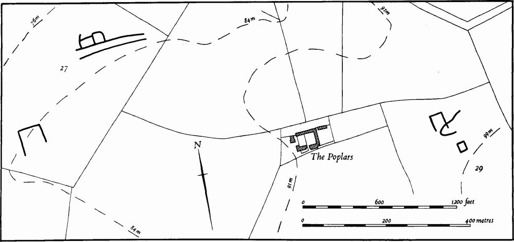
Fig. 160 Wollaston (27, 29) Cropmarks
b(32) Motte (SP 90856293; Fig. 161), known as Beacon Hill, in the centre of the village, 150 m. S. of the church, on Great Oolite Limestone at 76 m. above OD. In the 18th century it was also known as Mill Hill. It consists of an oval mound, 50 m. across from E. to W. and 60 m. across from N. to S., 5 m. high, with a flat top 25 m.–35 m. in diam. There are traces of a ditch on the S. side. There are no earthworks to indicate a bailey but a curving building-line of existing houses on the N. side of the mound, shown more clearly on a map of 1774, (NRO) before modern alterations, suggests the former presence of a small bailey not more than 30 m. across at its widest point. The mound was excavated in 1961–2 when a stone building, dated to the 12th century, was discovered on the summit. This was apparently destroyed soon after construction. Traces of an earlier structure were found under the mound. In the 13th century a post mill was erected on the summit (Whellan, Dir., 431; J. Bridges, Hist of Northants., II (1791), 199; VCH Northants., IV (1937), 58; Med. Arch., 14 (1970), 176).
b(33) Fishponds, Moat and Manorial Site (SP 90606315), on the W. side of the village on a steep W.-facing slope, on clay at 60 m. above OD. The earthworks were entirely destroyed in 1967 when the area was built over, but they were probably the remains of the Bury Manor, one of the two main manors of Wollaston (VCH Northants., IV (1937), 58–9). Bridges records that the name of the area was once Hall Yard, 'where according to tradition was formerly a mansion house' (J. Bridges, Hist. of Northants., II (1791), 199). Air photographs taken before destruction (RAF VAP CPE/UK/1994, 2228–9; CPE/UK/2546, 3137–8) show a rectangular embanked pond, 55 m. by 40 m., which lay near the N.W. corner of a large enclosure about 3 hectares in area and bounded by a bank and external ditch. To the N. were a number of smaller, ditched, rectangular enclosures with traces of building platforms within them, During the destruction of the earthworks a large quantity of medieval pottery, including St. Neots ware and 13th to 15th-century types, was found. Parts of the stone foundations of a wall were also noted (BNFAS, 2 (1967), 29; J. Northants. Mus. and Art Gall., 10 (1974), 38; inf. P. Foster).
On a map of the parish of 1774 and on the Enclosure Map of 1789 (NRO) the site is rather indistinctly shown. There is certainly a long pond marked at the E. upper end of the site, with a watercourse running down the slope to a rectangular ditched enclosure which may have been a moat. In the field to the S. a series of embanked closes still remain, with ridge-and-furrow within them. These appear to be abandoned paddocks which may have been connected with the rest of the site.
b(34) Manor House Site (SP 905624), S.W. of the village, on limestone at 65 m. above OD. The remains are the site of Hall Manor, one of the two main manors of Wollaston (VCH Northants., IV (1937), 58–9; J. Bridges, Hist. of Northants., II (1791), 199). The site consists of two conjoined rectangular embanked enclosures each covering about 0.5 hectares. The E. one has a series of rectangular platforms at its S. end, and part of a hollow-way in the S.E. corner. The W. enclosure is devoid of any interior features, but two small depressions to the S. are possibly ponds. Further S. again, near the stream, is a large embanked depression which is certainly a fishpond (CUAP, BKZ 56).
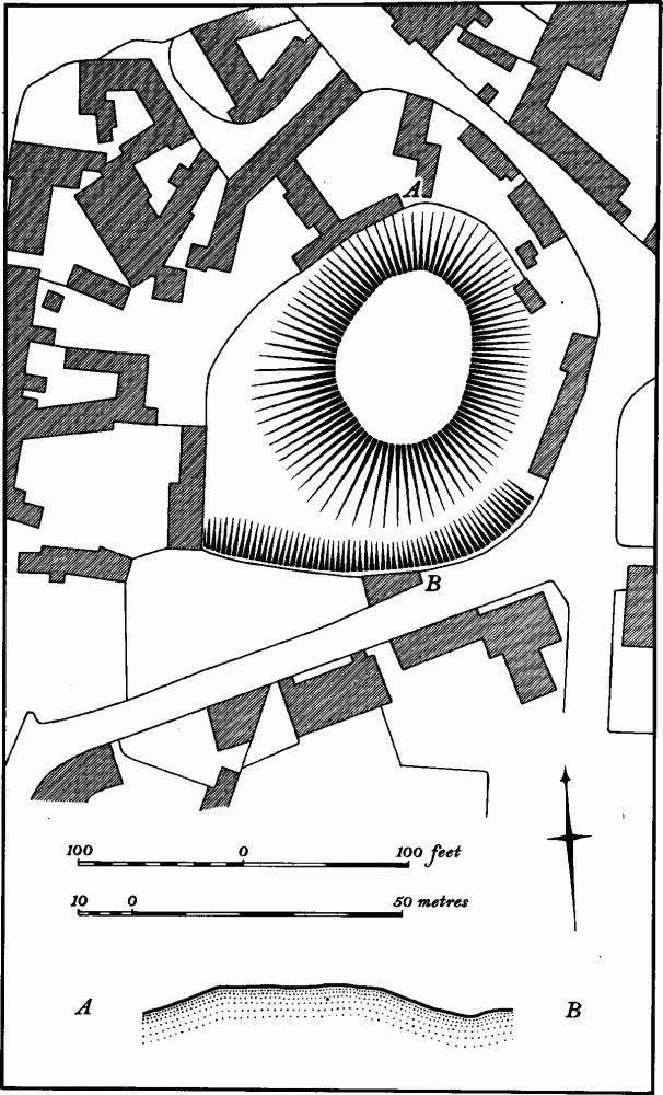
Fig. 161 Wollaston (32) Motte
b(35) Medieval Occupation Site (SP 90756340; Fig. 158), on the N. side of the village on the S. side of York Road. During building development medieval pits and ditches, building-stone and pottery, including Stamford ware, were discovered (BNFAS, 7 (1972), 53; NM).
(36) Cultivation Remains. The common fields of the parish were enclosed by Act of Parliament in 1778 (VCH Northants., IV (1937), 58; NRO, Enclosure Map, 1789). The Enclosure Map shows three fields, Nether, Windmill and Wood Fields. An earlier map (NRO, Map of 1774) shows the same fields, but marks Wood Field as Upper Field at that date. There were old enclosures around the village and in the N. of the parish, e.g. Coulstons Close (SP 905674) and New Close (SP 901649). Along the R. Nene in the W. of the parish was meadowland divided into strips and closes.
Ridge-and-furrow of these fields is visible on the ground or from air photographs around the village, and over much of Upper Field in the S.E., and Nether Field in the W. of the parish. Little remains in the area of Windmill Field. The ridge-and-furrow is arranged in both end-on and interlocked furlongs, some of pronounced reversed-S form. In Nether Field there is a series of end-on furlongs, separated by headlands up to 1 km. long and some 200 m. apart. The headlands lie on either side of and parallel with the road to Earls Barton, between SP 891634 and 898632. The modern road itself lies along the course of a very wide access-way which was known as Thatch Way Common in 1774, and the furlongs to the N. of it were North Side Thatchway and Black Muddy Lands, to the S. Southside Thatchway and Northside Millway, divided by Church Headland (RAF VAP F22 543/RAF/943, 0038–45; F21 543/RAF/943, 0036–45; CPE/UK/1994, 1201–4; F21 543/RAF/2409, 0133–5, 0161–2; F22 543/RAF/2409, 0133–5; F22 540/RAF/1312, 0291–7; F21 540/RAF/1312, 0290–7; 541/611, 4035–7; CPE/UK/2546, 4138–41, 3132–3, 3136–40).