An Inventory of the Historical Monuments in the County of Northamptonshire, Volume 3, Archaeological Sites in North-West Northamptonshire. Originally published by Her Majesty's Stationery Office, London, 1981.
This free content was digitised by double rekeying. All rights reserved.
'Everdon', in An Inventory of the Historical Monuments in the County of Northamptonshire, Volume 3, Archaeological Sites in North-West Northamptonshire, (London, 1981) pp. 80-82. British History Online https://www.british-history.ac.uk/rchme/northants/vol3/pp80-82 [accessed 13 April 2024]
In this section
27 EVERDON
(OS 1: 10000a SP 55 NE, b SP 65 NW)
The parish, covering some 1050 hectares, lies on the S. side of the R. Nene which forms its N. boundary. A small tributary of the Nene flows E. across the S. part of the parish and then turns N.E. to form part of the E. boundary before meeting the Nene in the N.E. corner. Both these watercourses are cut into the underlying Jurassic Clay between 90 m. and 120 m. above OD, producing an undulating landscape. However to the W. and S. the land rises steeply to around 180 m. above OD where the overlying Northampton Sand forms broad flat uplands. A number of minor streams cutting back into these higher areas have created steep-sided combes.
There were three medieval settlements in the parish though one, Snorscomb (3), is now deserted. The others are Great Everdon (4, 5) and Little Everdon (2), the latter having extensive settlement remains around it. A number of minor earthworks on the periphery of the parish have been recorded in detail elsewhere and are not listed below (Northants. Archaeol., 12 (1977), 155–76).
Prehistoric and Roman
A Neolithic flint axe was found in the parish in 1889 (T. J. George, Arch. Survey of Northants., (1904), 14; NM). Two middle to late Bronze Age palstaves, one looped and one unlooped, are recorded from the parish, although the former may be that listed under Staverton (NM; Plate 22).
(1) Roman settlement (?) (unlocated). During the 19th century Roman coins of Constantine, Constantius and Magnentius together with ashes and mortar were ploughed up in a field called Longsmall. The latter cannot be identified (G. Baker, Hist. of Northants., I (1822–30), 368; OS Record Cards).
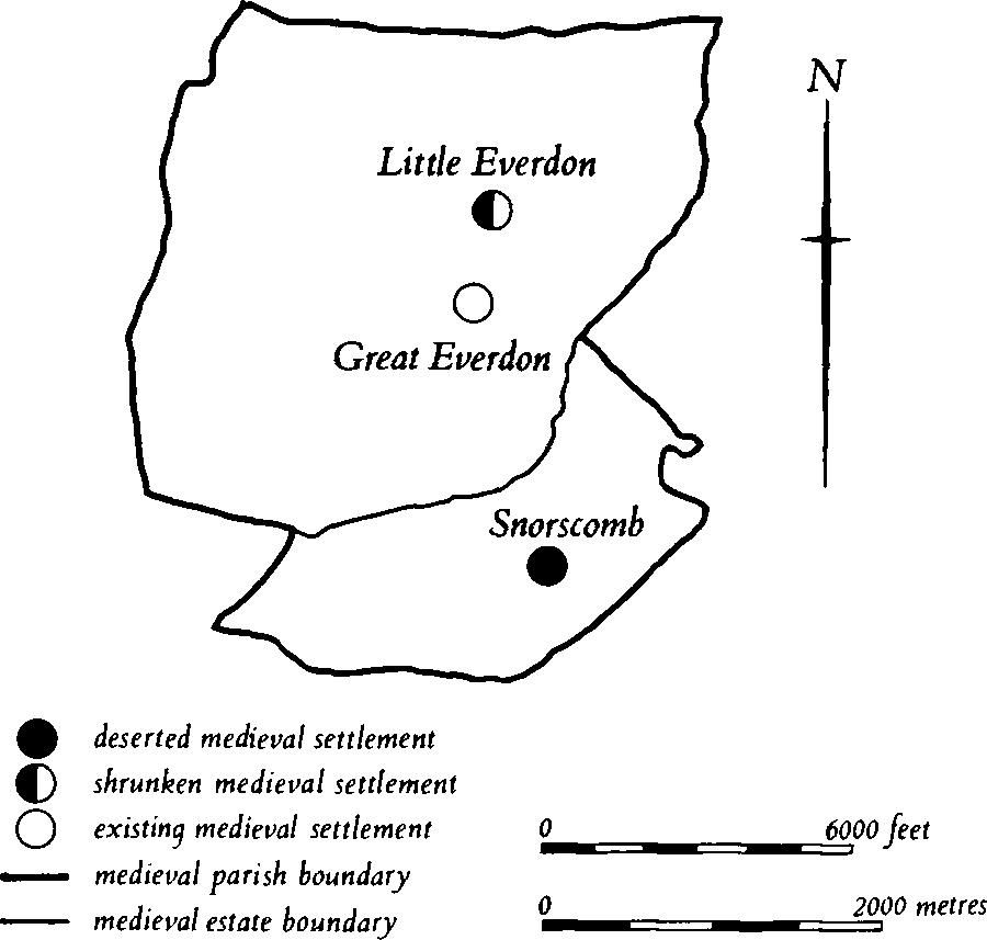
Fig. 64 Everdon Medieval settlements and estates
Medieval and Later
a(2) Settlement remains (centred SP 595581; Figs. 64 and 65), formerly part of Little Everdon, lie in and around the existing hamlet, on Middle Lias Clay between 107 m. and 122 m. above OD. Nothing is known of the population of Little Everdon in the medieval or later periods as in all the surviving records the hamlet is included with Great Everdon. Bridges (Hist. of Northants., I (1791), 58) noted that in about 1720 there were 17 houses, about the same number as today. The earthworks suggest that it was somewhat larger at one time, but this cannot be proved.
The remains fall into a number of separate parts. Immedately S.E. of the hall ('a' on plan) the W. part of the existing paddock has a sunken building platform on its S. side, lying above a broad hollow-way 1.5 m. deep which can be traced for some 80 m. to the E. Further S. ('b' on plan) is another small field with a number of indeterminate earthworks which indicate that buildings once stood there. On the S. is another hollow-way with a massive S. side 4 m. high and with more definite indications of former buildings on its N. side in the form of rectangular embanked or scarped platforms. The hollow-way runs E. and meets an existing lane.
Further W., on the N. side of the small valley ('c' on plan), are traces of former closes bounded by low scarps extending down the hillside; to the N. ('d' on plan) are other very disturbed earthworks, also possibly the sites of buildings. From these a hollow-way, damaged by later quarrying, extends W. up the hillside through ridge-and- furrow. The land to the S. of this hollow-way, between it and the road, was known as The Little Coneygree in 1863 (NRO, Map of Everdon). The whole hamlet is surrounded by ridge-and-furrow which is well preserved, especially in the park to the W. of the hall.
a(3) Deserted village of Snorscomb (SP 598561; Figs. 64 and 66), lies in the bottom of a broad open N.-facing combe, cut back into the Northampton Sand ridge to the S. It is situated at the junction of two small streams, on a narrow band of Marlstone Rock between 114 m. and 122 m. above OD.

Fig. 65 Everdon (2) Settlement remains at Little Everdon
Snorscomb is first mentioned in a Saxon Charter of 944 (BCS 792) where part of the bounds of its land is noted. It is next listed in Domesday Book of 1086 as held by the Count of Mortain and divided into two small manors of half and one and a half virgates respectively, with a total recorded population of only four (VCH, Northants., I (1902), 326, 329). In the reign of Henry II the place was assessed at four virgates (VCH, op. cit., 371). Little is known of its history after that time, beyond the descent of the manors. It is presumably included in all the national taxation records with Everdon. In 1531 the larger manor was purchased by the Knightley family of Fawsley who were soon prosecuted for the enclosure of 200 acres of land and the destruction of nine houses there (PRO, E1 59/298; E368/292). In the early 18th century Bridges (Hist. of Northants., I (1791), 61) described it as 'a hamlet of five houses, including the mill, but reputed to have been formerly a more considerable village'. By the early 19th century (OS 1st ed. 1 in. map (1834)) only the farm and a single cottage, both of which still stand, are shown, together with the mill which lies 500 m. to the N. on a larger stream (K.J. Allison et al., The Deserted Villages of Northants. (1966), 46). The original boundaries of the land of Snorscomb are shown on a map of the area of 1816 (NRO, reused as a Tithe Map in 1839; Fig. 64).
The remaining earthworks lie E. of the present farm and are mainly confined to a small triangular area between the two streams which meet a little to the N.W. Both streams are in small steep-sided valleys which appear to have been used as roads at some time and are thus partly hollow-ways. The main feature is a broad hollow-way up to 2 m. deep running S. from the existing cottage, which itself stands in the hollow. The hollow-way can be traced for some 60 m. to the S.E., after which it fades out. On the W. side of the hollow-way is a series of well-marked house platforms bounded by low scarps and stone-rubble walls up to 0.25 m. high. Below them to the W. again are small paddocks or plots edged by scarps. To the E. of the hollow-way only one possible building platform is visible but the area is divided into irregular paddocks. N. of the cottage, beyond the stream, are other earthworks, possibly part of the village, but damaged by later stone quarries which have been dug into them. Further S.W., and S. of the farm, are two ponds, the westernmost being deep and rectangular with a large surrounding bank. Another, shallower pond lies N.E. of the village site. Various other track-ways, not all of the same date, are visible running through surrounding ridge-and-furrow towards the village. An arable field to the N. of the present farm is said to produce large quantities of stone when ploughed and some medieval pottery has also been discovered there (local inf.; RAF VAP CPE/UK/1994, 3154–6; CUAP, SA46).
a(4) Pond and settlement remains (SP 59505735), immediately S. of Great Everdon church, in a small valley on clay at about 170 m. above OD. The valley floor here appears to have been widened and deepened to form a large depression about 1 m. deep. It may originally have been a fishpond. A little to the S.W. are two well-defined hollow-ways, and an area of disturbed ground possibly the sites of former buildings (RAF VAP 541/341, 3241–2).
a(5) Settlement remains (SP 596573), immediately E. of the church, on the S. side of the village, on clay at 105 m. above OD. At least three embanked closes extend S. from the existing gardens of some of the houses in the main street (air photographs in NMR).
(6) Cultivation remains. The common fields of Great and Little Everdon were enclosed by an Act of Parliament of 1763. Ridge-and-furrow of these fields exists on the ground or can be traced on air photographs over most of the parish, except along the edges of the stream which forms the parish boundary with Weedon Bec, where there was presumably always valuable meadowland. Probably as a result of the generally rolling nature of the land, with no steep slopes, the ridge-and-furrow is arranged in a pattern of interlocked furlongs of rectangular form. It is extremely well preserved in and around the park of Everdon Hall (SP 592582; partly on Fig. 65) and further W. (at SP 587583) where there are a number of interlocked furlongs with massive curved ridges up to 1 m. high.
The date of the enclosure of the common fields of the now deserted village of Snorscomb (3) is unknown but it was probably in the mid 16th century for soon after 1531 the Knightley family who then owned the manor enclosed 200 acres of land. This is about a third of the area of the land attributable to the village of Snorscomb (Fig. 64). Ridge-and-furrow of these fields exists on the ground or can be traced on air photographs over much of the land of Snorscomb except on the very steep slopes to the S. of the village. It is arranged in end-on and interlocked furlongs, except in the higher S.W. part (around SP 585555) where it radiates outwards around the projecting spurs. Large areas of well-preserved ridge-and-furrow exist N. and S. of the site of the village (RAF VAP CPE/UK/1994, 1162–7, 1270–4, 3159–62, 3152–6).