An Inventory of the Historical Monuments in the County of Northamptonshire, Volume 3, Archaeological Sites in North-West Northamptonshire. Originally published by Her Majesty's Stationery Office, London, 1981.
This free content was digitised by double rekeying. All rights reserved.
'Maidwell', in An Inventory of the Historical Monuments in the County of Northamptonshire, Volume 3, Archaeological Sites in North-West Northamptonshire, (London, 1981) pp. 135-137. British History Online https://www.british-history.ac.uk/rchme/northants/vol3/pp135-137 [accessed 19 April 2024]
In this section
45 MAIDWELL
(OS 1: 10000 a SP 77 NW, b SP 77 NE)
The parish is roughly rectangular, covering about 736 hectares, and lies across a series of spurs which project S. and E. from a ridge in the N.W. The latter, rising to over 165 m. above OD, is capped by Boulder Clay. The down-cutting of small streams has revealed narrow bands of limestone, rocks of the Lower Estuarine Series and Northampton Sand, with larger areas of Upper Lias Clay on the lower ground in the S. and E. The E. boundary of the parish follows a S.-flowing stream at about 90 m. above OD. Apart from a number of prehistoric, Roman and early Saxon sites discovered during recent fieldwork, the main monuments in the parish are two fishponds (14) and (15). Both are well preserved and one (15) is of particular interest because of the elaborate leat which formerly brought water into it.
Prehistoric and Roman
An Iron Age coin, a stater of the Atrebates, was found in the parish before 1868 (S. S. Frere (ed.), Problems of the Iron Age in Southern Britain (1958), 157).
a(1) Flint-working site (SP 731764), in the W. of the parish, on Northampton Sand at 152 m. above OD. Worked flints thought to be of Bronze Age type are said to have been discovered. No further details are known (CBA Group 9, Newsletter, 6 (1976), 29).
b(2) Flint-working site (SP 752781), in the N.E. of the parish on glacial sands and gravels at 130 m. above OD. Worked flints thought to be of Bronze Age type are said to have been discovered. No further details are known (CBA Group 9, Newsletter, 6 (1976), 29).
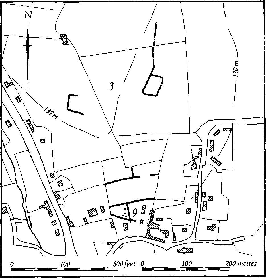
Fig. 103 Maidwell (3) Iron Age and Roman settlement, (9) Saxon settlement
a(3) Iron Age and Roman settlement (centred SP 747772; Fig. 103), lies N. of the village on Lower Estuarine beds and Boulder Clay, at 135 m. above OD. Air photographs (in NMR) show two rectangular enclosures; one is complete, with a linear ditch extending N. from it, but only part of the second is visible. Some Iron Age pottery has been found to the N.W. of the enclosures (SP 746774; Northants. Archaeol., 11 (1976), 184; CBA Group 9, Newsletter, 6 (1976), 29). Roman pottery, associated with further Iron Age sherds, has been found to the S.E., along the N. side of the Draughton road (SP 749772; inf. A. E. Brown). To the S., on the edge of the village, further cropmarks are visible. Most of these appear to be the remains of former closes of the medieval period, but at least one ditch and a number of pits may be pre-medieval in origin. (For Saxon pottery from this site, see (9)).
a(4) Iron Age and Roman settlement (?) (SP 725762), in the extreme S.W. of the parish, on Northampton Sand at 152 m. above OD. Early Iron Age and Roman sherds have been recovered (Northants. Archaeol., 11 (1976), 184, 192; CBA Group 9, Newsletter, 6 (1976), 29).
a(5) Iron Age and Roman settlement (?) (SP 738771), W. of the village on glacial sands and gravels at 140 m. above OD. Pottery of late Iron Age and Roman types has been discovered (Northants. Archaeol., 11 (1976), 184, 192; CBA Group 9, Newsletter, 6 (1976), 29).
a(6) Roman settlement (?) (SP 733770), W. of the village, on Northampton Sand at 135 m. above OD. Roman pottery has been found (Northants. Archaeol., 11 (1976), 192; CBA Group 9, Newsletter, 6 (1976), 29).
b(7) Roman settlement (?) (SP 751762), in the S.E. of the parish, on Northampton Sand at 115 m. above OD. Roman pottery has been found (CBA Group 9, Newsletter, 6 (1976) 29; for Saxon finds from this site, see (13)).
a(8) Roman building (SP 729763), in the W. of the parish on Northampton Sand at 155 m. above OD. Roman pottery, building stone and hypocaust tiles have been discovered (Northants. Archaeol., 11 (1976), 192; CBA Group 9, Newsletter, 6 (1976), 29; for Saxon pottery from this site, see (10)). To the S.E. air photographs (in NMR) show very indistinct cropmarks of at least two sub-rectangular enclosures and some short lengths of ditches.
Medieval and Later
a(9) Saxon settlement (?) (SP 747772; Fig. 103), on the same site as the Iron Age and Roman settlement (3). A small quantity of early Saxon pottery has been noted (inf. A. E. Brown).
a(10) Saxon settlement (?) (SP 729763), found with the Roman building (8). Areas of early Saxon pottery have been found in the vicinity (Northants. Archaeol., 11 (1976), 192; CBA Group 9, Newsletter, 6 (1976), 29).
a(11) Saxon settlement (?) (SP 727763), 200 m. W. of (10) in a similar situation. Early Saxon sherds have been discovered (CBA Group 9, Newsletter, 6 (1976), 29).
a(12) Saxon settlement (?) (SP 735769), in the W. of the parish, on Northampton Sand at 126 m. above OD. Early Saxon pottery has been discovered (CBA Group 9, Newsletter, 6 (1976), 29).
b(13) Saxon settlement (?) (SP 751762). Some early Saxon sherds have been found with the Roman material (7) (CBA Group 9, Newsletter, 6 (1976), 29).
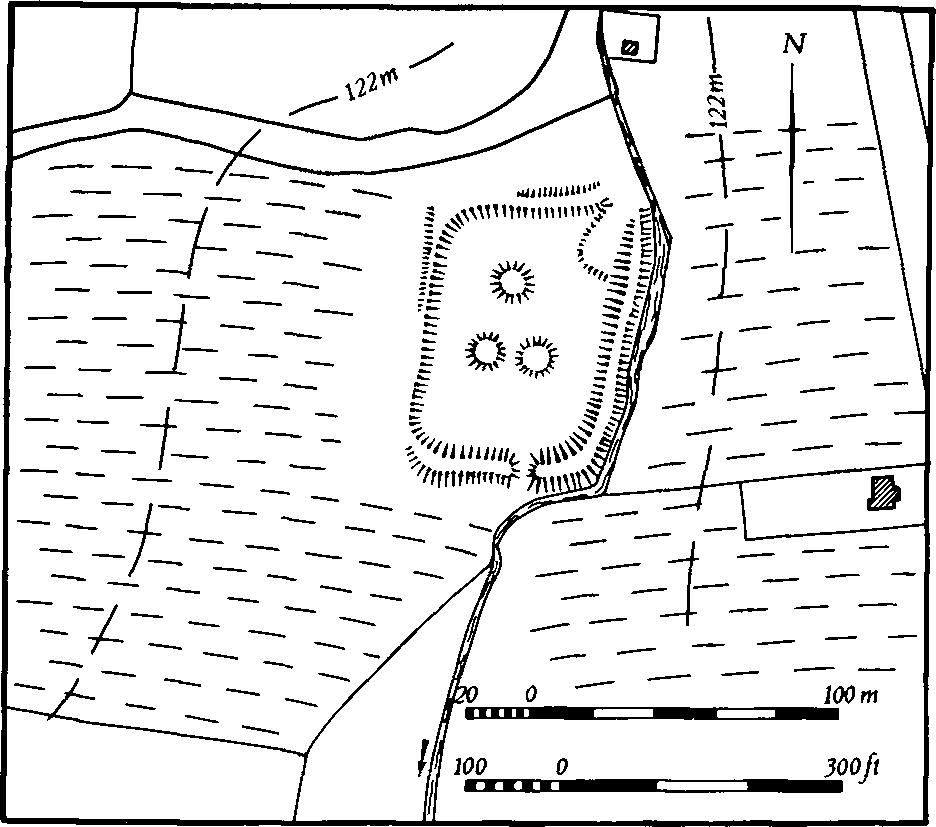
Fig. 104 Maidwell (14) Fishpond
a(14) Fishpond (SP 745766; Fig. 104), lies S.W. of the village on Upper Lias Clay at 120 m. above OD. The pond is rectangular, 85 m. long and 60 m. wide, lying on the W. side of a small stream. The gently sloping valley side has been cut away to give the pond a level bottom on which three slight mounds about 10 m. in diam. are still discernible. These mounds must have been islands or, more likely, shallow places in the pond, possibly for the benefit of waterfowl. The water was retained on the S. by a massive earthen bank which still stands more than 1.5 m. high and 12 m. across. There is now a modern breach in it. The pond is also embanked along the whole length of the E. side and for a small section of the W. side. In the N.E. corner, where the stream must originally have fed the pond, is a delta-like feature which may be the result of later activity. The surrounding ridge-and-furrow, especially on the W., appears to be later than the pond (Northants. P. and P., 4 (1970), 307; RAF VAP 106G/UK/636, 4189–90).
a(15) Ponds (SP 741764; Fig. 105), lie S.W. of the village, N. and E. of Dale Farm, in a steep-sided valley cut into Upper Lias Clay between 105 m. and 120 m. above OD. Nothing is known of the date and function of either pond, though presumably the larger one to the N.W. is earlier than the smaller one.

Fig. 105 Maidwell (15) Ponds
The upper pond, known as Dale Pond, is now reduced to a small area of water but even in recent times it was much larger and in the early 19th century (1st ed. OS 1 in. Map (1834)) it covered 3 hectares and extended for some 300 m. along the valley. The water was held back by a massive dam some 2 m. high which now has a later cut through its centre. When the lake was full the water flowed across the N.E. end of the dam and ran along an artificial raised leat cut into the valley side. This leat, which still survives, curves S. and S.W. as a channel 3 m. deep and now returns N.W. to meet the existing stream. However in earlier times it flowed S.E. and entered the smaller pond. This is a long rectangular depression, cut into the hillside to a depth of 1.5 m. and bounded on the S.W. and S.E. by a large bank up to 2.5 m. high. A large gap in the centre of the S.W. side appears to be secondary but as there is no other outlet it may be in the same position as an original one (RAF VAP 106G/UK/636, 4189–90).
(16) Cultivation remains. The common fields of the parish were enclosed privately between 1686 and 1711 (CBA Group 9, Newsletter, 6 (1976), 29). Most of the ridge-and-furrow in the parish has been destroyed but some can still be traced on the ground or from air photographs especially in the N.W. and N.E. of the parish and S. of the village. Elsewhere only a few blocks remain. Much of what survives is arranged in end-on furlongs, in the E. of the parish mainly orientated E.–W., and in the N. of the parish orientated N.–S., in response to the general topography of the area (RAF VAP CPE/UK/1994, 2451–5, 4455–8; 106G/UK/636, 4186–93, 3188–92).