An Inventory of the Historical Monuments in the County of Northamptonshire, Volume 6, Architectural Monuments in North Northamptonshire. Originally published by Her Majesty's Stationery Office, London, 1984.
This free content was digitised by double rekeying. All rights reserved.
'Sectional Preface: General', in An Inventory of the Historical Monuments in the County of Northamptonshire, Volume 6, Architectural Monuments in North Northamptonshire, (London, 1984) pp. xxxiii-l. British History Online https://www.british-history.ac.uk/rchme/northants/vol6/xxxiii-l [accessed 27 April 2024]
In this section
NORTH NORTHAMPTONSHIRE
SECTIONAL PREFACE
TOPOGRAPHICAL AND HISTORICAL INTRODUCTION
The present Inventory covers twenty-four parishes in the extreme N.E. of Northamptonshire (Fig. 1). Most of these parishes lie on a dissected limestone plateau about 100 m. above OD, which is covered by a layer of Boulder Clay of varying thickness. Towards the E. of the area these Jurassic limestones are cut by the valley of the River Nene, which consists of a mile-wide band of silts and gravels in the flat valley bottom. To the S.E. is a sparsely-populated ridge formed of Jurassic clays and also largely covered by Boulder Clay. To the N. the area is bounded by the River Welland, which flows in a deep narrow valley; the Willow Brook runs eastward across the middle of the area and flows into the Nene at Fotheringhay (Figs. 2, 3).
Although there is considerable evidence for prehistoric and Roman occupation (RCHM, Northants. I, xxiii) the whole area seems to have been heavily wooded by the late Anglo-Saxon period. By the end of the 11th century the present pattern of villages had been established. The Jurassic clayland to the E., known as Bromswold, had been largely cleared of woodland, but considerable areas remained unreclaimed on the limestone plateau. The medieval system of parishes was in existence by the early 12th century, and the modern parish boundaries reflect the areas of land attached to each village by that time. At the time of the Domesday survey in 1086 three large areas of land lay outside the boundaries of the villages and parishes; lying mainly on the thicker Boulder Clay on the limestone plateau, they were known as Morehay, Sulehay and Westhay (Figs. 4, 8). After the Conquest they were claimed by the Crown, which already owned the villages of Apethorpe, Duddington, King's Cliffe, Nassington and Tansor. In the post-Conquest period this crown estate was centred on King's Cliffe where there was a royal house or hunting lodge, but there is some evidence to suggest that formerly Nassington, with its large parish incorporating the villages of Apethorpe and Yarwell, had been the main centre. This royal estate and the three extra-parochial areas which lay adjacent formed the basis of that part of Rockingham Forest which was known as Cliffe Bailiwick, and which forms the core of the present Inventory (Fig. 4).
Rockingham Forest was established by the early Norman kings. Cliffe Bailiwick was one of three administrative divisions of the forest, and was entirely detached. The boundaries of the forest (Fig. 4) as given in the perambulation of 1299 and as interpreted by Pettit (The Royal Forests of Northamptonshire, 1558–1714 (1968), Map 1) give a sufficiently accurate indication of its extent. The creation of this forest had important administrative and economic implications. A different legal system was imposed on the parishes within the forest, keeping close control over all aspects of life that impinged on the management of timber and game. This situation lasted until the 17th century, by which time these laws were losing their importance; the forest walks were then leased to local landowners, principally the Earls of Exeter and Westmorland, who managed them as part of their own estates. Economically the villages were affected by the availability of forest products such as timber, bark and skins, and by the possibility of pasturing animals and even of assarting land in the forest and purlieu woodlands.
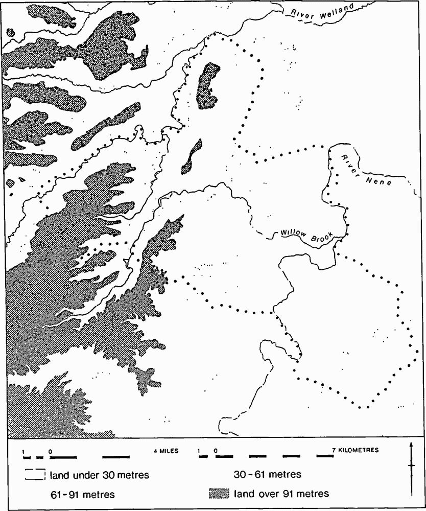
Fig. 2 Map showing the physical setting of the Inventory area
After the Conquest, the development of settlement differed inside and outside the forest. Within the forest, Southwick village grew as a hamlet of Perio and finally became the major, and, ultimately, the only settlement of more than a single farm in the parish. Yarwell, which like Southwick was not mentioned in Domesday Book, may have grown as a hamlet of Nassington. Otherwise there were no major extensions of settlement after the creation of the forest. Assarts, agricultural clearances in the woodland, are recorded but except for Provost Lodge and Bulwick Short Leys few houses were built on them. Provost Lodge is now in Glapthorn parish, and an inquisition was held before permission to build was given. An abandoned site now in Southwick but formerly in Morehay could have been a forester's lodge, of which six are recorded in the early 17th century (RCHM, Northants. I, Southwick (14)). Two villages, Hale and Perio, were deserted, the former because of the Black Death, but otherwise the only changes in settlement were changes in size of village.
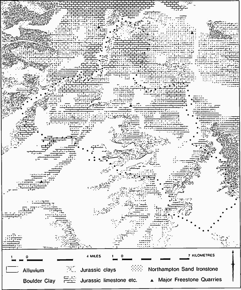
Fig. 3 Geological map of Inventory area
Outside the forest, and especially on the clay ridge, there were more fluctuations in the pattern of settlements. Several parishes had secondary settlements, and of these the hamlets of Elmington in the Nene valley and Armston, Eaglethorpe, Kingsthorpe and Papley on the Jurassic Clay ridge have all shrunk or vanished (Fig. 4).
In the post-medieval period the agrarian economy of the area was one of mixed farming with an emphasis on animal husbandry. Sheep had long been of importance, and Richard Knyvet's wool-trading activities in the 14th century are paralleled by those of the Brudenells in the 16th century (J. Wake, The Brudenells of Deene (1953), 42). Sheep were still of great importance in the 17th century, when the weaving of coarse shalloons and fine tammies was a major domestic industry in the area. The forest villages had rights of pasture, particularly in the extra-parochial walks of Morehay, Sulehay and Westhay, and these made it possible for farmers to have sizeable flocks of sheep and herds of cattle. More important, men with little or no land could run their stock in the forest. Probate inventories of the late 17th century include many craftsmen with two or three cattle and up to two dozen sheep, but rarely more than an acre or two of arable land. That even men without any land could make at least a poor living from keeping cattle, sheep and pigs in the forest had considerable consequences and drew impoverished labourers from other less favourable parts of the county. Arable farming was devoted to wheat, barley, peas and beans. Although there was some early enclosure for sheep farming on the Jurassic Clay ridge, many of the open fields in the forest remained unenclosed until the late 18th and early 19th centuries. In addition to agriculture and its allied trades such as milling, the forest provided raw materials which supported trades such as tanning, leather work and wood turning. The beds of good building stone and stone slate in the area worked from the Middle Ages onwards provided employment for quarrymen, and also encouraged the rise of a body of masons and slaters who mainly lived in the quarry-villages but worked wherever their services were needed.
The population of the area has fluctuated considerably. Domesday Book indicates a relatively low population density in the late 11th century. In common with the rest of England the population increased up to the beginning of the 14th century, although physical evidence for this is slight. The progressive increase in the size of churches up to the late 12th century is only partly a reflection of this growth, as liturgical and economic factors were also involved. On the Jurassic Clay ridge the population began to recover from the crises of the 14th century only to decline again from the early 15th century onwards. Kingsthorpe and Lutton declined in the early 15th century, Eaglethorpe, Elmington and Papley were depopulated, probably for sheep, in the late 15th and early 16th century, and Armston declined in the 16th century. This clayland is today sparsely populated and the villages are small. In the forest, however, the population rose considerably in the late 16th century, some villages such as Duddington and King's Cliffe increasing dramatically (NRS, 23 (1968), 142). Much of this increase seems to have been the result of immigration by landless labourers attracted by the availability of unstinted common pasture in the forest, and in the late 17th century the Hearth Tax returns show that the forest villages still had an unusually high proportion of families exempt from the tax or living in single-hearth houses. It is in the context of this rural poverty that William Law carried out his charitable works, including the provision of a soup kitchen, at King's Cliffe in the mid 18th century. Contemporary observers recorded that many of these poor immigrants were housed in small cottages, converted farm buildings, and sub-divided houses (PRO, E146/2/5 f. 3). None of these buildings survive, and the only physical evidence for the influx of people may be the indications of expansion in the plans of some villages such as King's Cliffe, and in the subdivision of former copyhold tenements. Attempts to restrain new building in the forest villages were made in 1577, 1616 and 1620, but were of little avail (NRS, 23 (1968), 145).
A further major increase in population began in the late 18th century and affected the whole area, numbers rising from 6746 in 1801 to 9610 in 1851. After the middle of the century the population steadied and then decreased. How these extra families were housed is easier to detect than with earlier periods for many more relevant buildings survive. Only three converted farm buildings have been identified, at Easton-on-the-Hill (69), Fotheringhay (10) and King's Cliffe (85). A larger number of sub-divided houses have been recorded, although some, such as Apethorpe (15), resulted from a change in estate organization and not population increase. Most families were housed in new buildings, some on new sites but the majority on sub-divided old sites within the village. Enclosure of the open fields made it easier to change the use of farmland to cottage site, but most new cottages were on unimportant plots along road sides, or else on old house-sites. The group of copyhold tenements in the S.E. corner of Collyweston village was sub-divided to provide some minute plots each capable of holding only a single-room cottage.
Villages
Morphology
The shape of most of the villages in the area is based on a single straight street, usually with a parallel back lane. Collyweston, Woodnewton and Yarwell are of this form, are very regular and appear to have been deliberately planned. Wakerley has an early settlement S. of the church, to which a regularly planned single-street extension has been added on the W. This extension and the villages of Tansor and Cotterstock all seem to have had houses on one side of the street only. Bulwick has been united with its neighbour Henwick to produce an extended plan and the very complex villages of Easton-on-the-Hill and Warmington have also been formed by the amalgamation of several separate centres. Both of these last villages had more than one manor in 1086. Laxton has a green, and evidence survives in the plans of Duddington, King's Cliffe, Fotheringhay and Warmington for other greens, but all have been encroached upon.
Within most villages there was a compact block of glebe land, the largest examples being at Easton-on-the-Hill and Warmington. In several villages, notably Collyweston, Woodnewton, Yarwell and probably Tansor, this former glebe is part of the regular pattern of crofts; at Woodnewton and Yarwell it contains the church. At Tansor the church stands in a separate plot on the unoccupied side of the street.
Changes in the size and plan of villages are reflected in the present topography but not generally in the distribution of the standing buildings. The 18th-century houses in Stamford Road, Easton-on-the-Hill, may be the first houses on this by-pass road, but they do not date from its inception. There are several instances, such as at Wakerley, where the village has moved away from its church, but nowhere has a church been entirely isolated.
Ownership and Tenures
The changing pattern of landed estates has had an effect on the building history and the topography of the area. A few landowners had land in only a single parish, and their relatively modest houses, such as Cotterstock Hall, Easton Manor, and Lutton Manor, stand in the villages, surrounded by small houses. The houses at the centres of the main medieval estates in the area have all gone; they included the royal house at King's Cliffe, the castle of Fotheringhay, and the Zouche house at Harringworth. By the early 16th century the crown estate had been broken up, Fotheringhay had ceased to be an important castle, and the Zouche family was declining, their local estates eventually passing to the Tryons who moved to Bulwick. Collyweston had a large house unattached to any major landholding. Within the area two new estates had emerged based on Blatherwycke and Apethorpe, while outside the area there were estates being built up around Burghley and Deene. The dissolution of the monasteries helped the Montagu family to complete the acquisition of Hemington parish, and provided at Fineshade a home for the Kirkham family. During the 18th century the Stafford estate was divided, creating two smaller estates based on Blatherwycke and Laxton.
The appearance of the villages, and the nature and range of houses built, were greatly affected by the pattern of land tenure. Throughout the 16th century the usual policy of major landowners in the area was to form relatively compact holdings. They preferred to concentrate their holdings in a small number of parishes and they also tried to consolidate their holdings within each village. Guy Wolston's estates were confined to a small group of contiguous parishes, and his successors did not extend their acquisitions beyond those limits. The Montagu family gradually acquired all of the manors in Hemington, gaining first control and then total ownership of the parish. Within the consolidated holdings thus created, it was possible to reorganize both demesne and customary farms into larger units which would give a better financial return in the form of increased rents. Usually farms of various sizes were made by amalgamation of land, although in 1630 the land of Glapthorn was redistributed to form 66 acre (27.5 hectare) farms. These policies of agricultural and estate improvement necessitated the provision of houses suitable for the tenants of large farms. The engrossing or rearrangement of farm land was sometimes accompanied by the amalgamation or abandoning of associated house sites in the villages. The topographical results can be seen clearly in many villages. In Nassington there are several large farmsteads formed by amalgamating house sites (for example (35), (43)) and also a number of vacant sites, all of them belonging to the Earl of Westmorland's estate. The management policies of the Earls of Exeter can be seen at Easton-on-the-Hill, where they account for the series of wide-fronted plots with farmhouses, scattered throughout the village. At Wakerley, where they owned almost the whole village, the effect was even more drastic.
A further common policy of the major landowners was to buy or acquire all of the copyholds in the parish in which their own house was situated. The result was that by the 18th century those villages which had had a resident landowner since about the middle of the 16th century were owned entirely or almost entirely by that landowner. This applies at Apethorpe, Blatherwycke, Fotheringhay, Harringworth, Hemington, Laxton, Southwick and Wakerley, and contrasts with the more open situation in other parishes where the same families were major property owners. The owners of copyhold and freehold tenements were responsible for their own houses and had freedom to dispose of their houses and land. Consequently it is mainly among copyholders that we hear of barns and farm buildings being converted into dwellings (PRO, E146/2/5, f.3, for 1577) and of tenements being sub-divided, so that copyhold tenements are now those with the narrowest frontages. Leaseholders and customary tenants, on the other hand, were under the close control of the landowner and lord of the manor. Subdivision and amalgamation of holdings was a matter of wider policy, and the building and repair of houses was at least partly financed by the landlord. In the 17th century repair seems generally to have been the responsibility of the tenant, with necessary 'great timbers' provided by the owner. By the 18th century the estate accounts of the Cecils, Fanes and Tryons show the landlord himself bearing the cost of repairs and rebuilding, although a few repairing leases have been identified.
The houses built in the villages of Nassington, Woodnewton and Yarwell have been examined for differences occasioned by the type of tenure under which they were held. Of 112 tenements, 69 were freehold and copyhold, and 43 belonged to the Earls of Westmorland whose holding appears to have been static from at least the mid 17th century. There were no differences in the distribution of house types between the two groups in the 17th century, although the majority of two-storey houses were on copyhold plots. In the 18th and 19th centuries, however, the differences increased. Most central service room houses of class 5 were on Westmorland plots, whereas most single and double pile houses of classes 6 and 8, (see Classification of Post-medieval Houses) and indeed most three and four-room houses, were copyhold. The majority of thatched houses were also on the Westmorland estate. Although there are differences between the villages, in general the Earls of Westmorland built few houses of more than two rooms after the 17th century, and tradesmen and craftsmen seem to have been attracted to copyhold land. In the 19th century their modest houses were less traditional and made greater attempts to be 'polite' than those of the Westmorland estate. On the Exeter estate there is nothing to compare with the 9th Earl's building campaign in Stamford in the late 18th century (RCHM, Stamford, lxxxii). At Easton-on-the-Hill all but one of the eleven houses were of two-room plan, but those built in the 19th century were modestly fashionable symmetrical houses of class 6b. Only two landowners attempted a complete rebuilding of a village, at Blatherwycke and Laxton, although much new building was done at Fotheringhay.
Siting of Houses
Within the villages, houses are generally built parallel to the street, irrespective of the slope of the ground. All of the villages in the area seem to have been laid out in their present form with plots wide enough for a three-room, house, and any narrower plots appear to be the result of subsequent subdivision. About 50 houses, mainly of the 17th and 18th centuries and many of them in Easton-on-the-Hill, were built at right angles to the street. In many cases the plot was too narrow to take the house that was built except aligned along its length. Although a few 17th and 18th-century three-room houses were built on an L-shaped plan on narrow sites, as at Collyweston (28) and (29), there was clearly an unwillingness to adapt the plan of the house to meet the exigencies of the site. There was a marked tendency for houses built at right angles to have their service or working rooms at the end farthest from the street. All 17th-century houses of class 1a and 4a built at right angles were arranged in this way, so that the gable towards the street contains a display of windows and sometimes a datestone, as at Easton-on-the-Hill (23) of 1688.
A number of houses, mainly of the 17th century, were built parallel to the street but were entered only from the back. Most have since had a door broken through on the street front, so that it is now impossible to tell how many houses were originally entered in this way, but it was probably a considerable number. Warmington (18) dates from the 17th century and Harringworth (22) is a later house whose very size makes the lack of a door in the front wall visually remarkable. Several houses such as Bulwick (12) and Warmington (21) are easier to understand if they are assumed to have had no entrance in the front. The need to supervise the approach to the house or to deter trespassers may be suggested as reasons for adopting an entrance at the rear, but several houses show that direct access from the house to yard or garden was more important than that to the street. Similar factors operate in the present century with the result that side or back doors are today used in preference to the front door.
Most houses in the area are built on the street frontage, the exceptions being cottages on sub-divided plots or large houses deliberately set back such as King's Cliffe (32) and (86). In the early 19th century some small houses were set back for visual effect, usually in association with picturesque estate buildings as at Blatherwycke and Laxton. Cottage gardens at the front of the house and visible to the public are a picturesque element rarely found before 1800 and not very common thereafter in this area. The problem of access from the street to the yard behind for farm purposes has resulted in many houses being placed in one corner of the plot, giving maximum space for wagons and animals to pass back and forth. The same consideration may have determined the building of some houses at right angles to the road, where an L-shaped plan would have occupied the full width of the plot and blocked access.
Forests and Parks (Fig. 4)
The forest was an area set aside by the early Norman kings for the management of vert and venison, that is of timber and game. The woodland was managed in the usual medieval way, mainly by coppicing, leaving standards or isolated trees to grow large enough for timber. Game, in practice deer, for boars had become rare by the 13th century, browsed the trees and ate grass in specially made clearings or lawns.
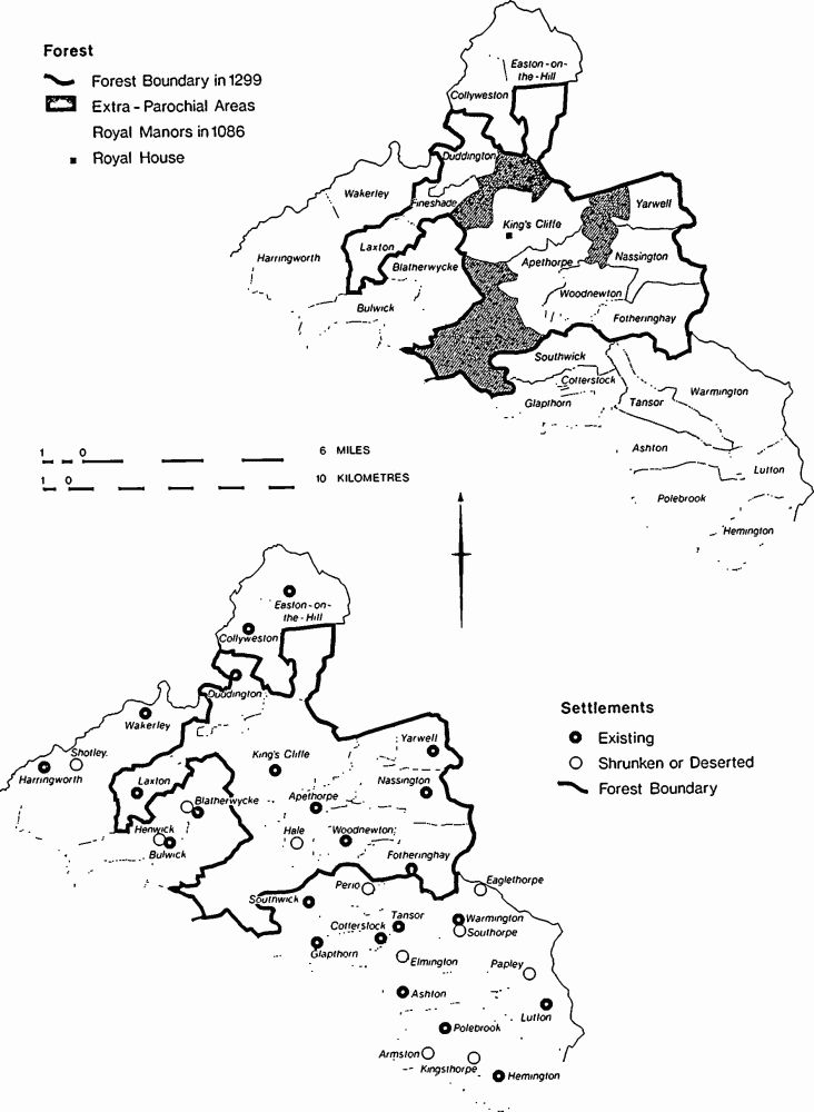
Fig. 4 Maps showing the Forest of Rockingham and medieval settlements within the Inventory area
Rockingham Forest was administered from Rockingham Castle, and was divided into three sections or bailiwicks, of which the easternmost was that of Cliffe. Day-to-day management was in the hands of a variety of local officers. Sulehay Walk was kept by a forester who from at least the 13th century held Sulehay Lodge and 30 customary acres of arable land by virtue of this (Cal. IPM, vol. 1, 220), and the control of vermin was a serjeanty connected with the manor of Laxton by the 15th century (Cal. IPM, Henry VII.I, p. 238). In 1487 the Master Forester at Rockingham had a salaried staff of eight verderers, palers and clerks, and 34 wage-earning foresters; the money available was sufficient to pay the foresters for an average of three days a week, so they clearly augmented their pay by perquisites and pasturing animals in the forest (Cal. Pat. (1485–94), p. 161). How many of these officers lived in lodges in the forest is not clear, but in Cliffe bailiwick Sulehay Lodge was occupied by the early 13th century and Morehay Lodge by the late 16th century. The remaining three lodges in Morehay Walk are mentioned in the 17th century, and in 1762 the keepers' salaries ranged from £8 to £12, indicating a continued reliance on other sources. Some form of farming is indicated by the building of a barn at Morehay Lodge in 1610; Westhay Lodge was a small 17th-century house with a barn rebuilt in 1790 (King's Cliffe (88)). The only other lodges on the Earl of Westmorland's walks of Morehay and Sulehay became the centres of large farms, although the surviving buildings are mainly of the later 19th century. In Westhay the Earls of Exeter felled most of the trees and built two new large farmhouses after 1850. Today most isolated farms in the area are called 'lodges' irrespective of their origins.
Purlieu woods were outside the legal forest, and were managed separately, being under private ownership. At the beginning of the 17th century Lord Burghley employed Anthony Markham as Woodward; Markham lived at Duddington (11) and was an administrative official of some standing.
Within the forest, the king had from at least the early 13th century an enclosure or park at King's Cliffe for the further protection of deer, mainly the locally rarer red deer as distinct from fallow deer. Private individuals also made parks, under licence, for the pleasure of hunting, at Wakerley in 1228, Easton-on-the-Hill in 1229, Fotheringhay c. 1230, Harringworth in 1234 and Bulwick before 1272. Further parks were made at Collyweston in the early 15th century, Apethorpe in the early 16th century, and Blatherwycke in 1560. Some of these parks had a lodge or stand, mainly for watching the hunt and for eating in. The only survivor in the area, at Harringworth (32), dates from the 15th century and seems to have had a single large room on each of two storeys; in this it resembled its predecessor, described in 1272 as a chamber above a cellar. A similar building stood in Bulwick park at the same time (NRO, T(B) 2). There was probably a stand in Apethorpe park on Kingstanding Hill and the stand at Collyweston was reslated in 1624 (PRO, SP 14/190). Parks also contained houses of their keepers; they too were called lodges, and it is not clear when they first appeared. By 1593 there were three lodges in King's Cliffe park, Middle Lodge being deemed suitable lodging for 'a gentleman of worth' (Ex. MS. 57/6). Cheesemans Lodge was probably built for the keeper of Apethorpe park in the 17th century; none of the lodges in the area of the present Inventory became houses of 'gentlemen of worth'.
The deer were generally left to fend for themselves, browsewood being cut for them in winter when food was scarce. Shelters were sometimes provided to protect them from the rigours of winter, although none survives. The deer lodge in Apethorpe park was converted into a barn by 1700 (NRO, W(A) 6.XII) and the lodge at Morehay had been made into lambing sheds by 1892.
BUILDING MATERIALS AND TECHNIQUES
Masonry
Except in the E. where the Oxford and Kellaways clays outcrop, almost the whole area is underlain by Jurassic Limestone or sandstone (Fig. 3). Only Hemington. Lutton and Papley on the clay, and Tansor and Fotheringhay on the river gravels of the Nene valley are more than half a mile from a source of usable building stone. Consequently stone became the universal building material. Walls are generally of rubble laid in courses and won from fairly close to the building. Only freestone was carried for any distance, and was used for dressings to quoins, openings and parapets, and for facing, fireplaces and chimney stacks. The carriage of walling stone was uneconomical over more than short distances, particularly for small houses and cottages, and consequently the effective boundary of the region of universal stone building lies one mile E. of the geological boundary between Jurassic rocks and Jurassic clays.
The builders of large houses were able to finance the transport of stone over greater distances and thus some stone manor houses and large farms are found further E. again. The Lower Lincolnshire Limestone, for instance, is only used as a rubble walling stone near its outcrop; even more obvious is the distribution of Northampton Sand ironstone which is readily identified by its colour and was used only within about half a mile of its outcrops. In 1281 freestone was quarried at Weldon and Stanion for Rockingham Castle, but the rubble was from Rockingham itself (PRO, E101/480/25). At Collyweston Manor the rubble was dug at Collyweston and Easton between 1500 and 1506 but freestone came from Clipsham, King's Cliffe, and Weldon, and a further 325 cartloads were brought from the dismantled house at Thorpe Waterville (St. John's Coll. Camb., MS 91.14). In 1720 Blatherwycke Hall was built of rubble dug in the park, and faced with King's Cliffe stone (NRO, OB(B) 12). At Laxton stone for the Hall was raised mainly from a quarry 300 m. N. of the house, and unusually freestone was also available from this source so that only small quantities were brought from Ketton, King's Cliffe and Weldon. A 5ft (1.5 m.) gauge railway 30 m. long was laid in connection with mining the stone for the house. Northampton Sand ironstone was rarely used for dressings in the area, local outcrops generally producing too soft a stone. It was used in houses and the church at Harringworth, and for the great columns in the E. range at Apethorpe Hall in 1623.
The choice of freestone was always made with great care, and excellent stone was available at different times from quarries at Barnack, Clipsham, Ketton, King's Cliffe, Stamford and Weldon, all in or very near to the area, and all from different beds of the Upper Lincolnshire Limestone. For most work, the preferences of masons changed over the centuries. The coarse shelly oolites such as Barnack were replaced in favour by less shelly oolites from Clipsham. King's Cliffe and Weldon, and finally by even-textured oolites from Ketton and Stamford.
The earliest recognizable sources of freestone in the area are Barnack and Weldon. The Barnack quarries are documented from the 11th century onwards and those of Weldon from the 13th century (VCH, Northants. II, 293, 295), and the coarse shelly hard stone associated with Barnack is found used in 11th and 12th-century churches in the area. Despite its texture it was used for carved work, the earliest being the late Saxon cross-shaft at Nassington. In the 12th and 13th centuries it was used for stone coffins and their decorated lids which served as floor monuments, and the distribution of these floor slabs all in the same stone and similar styles over a wide area suggests a group of masons working at Barnack producing finished carved work, Barnack stone was still used for special purposes long after it ceased to be preferred for carved work. The base of the 15th-century tower at Easton-on-the-Hill church, for instance, is built of hard Barnack up to the top of the ground-table.
By the 13th century the fine textured stone from Weldon and Stanion was being exploited, freestone from both quarries going to Rockingham Castle in 1281, and it was used for carved work at Apethorpe Hall in 1653. By 1460 the similarly fine-grained stone from King's Cliffe was sufficiently well-known to be used for King's College Chapel, Cambridge (RCHM, Cambridge City, 99), and during the 17th and 18th century it was a source for stone for Blatherwycke Hall and the orangery at Apethorpe Hall. From the early 17th century, however, the even-textured oolite from Ketton, almost entirely without shells, was used in increasing quantities. In 1634 Ketton was chosen for the proposed new manor house at Collyweston (NRO, NPL 1339), and c. 1740 it was employed to face the Palladian remodelling at Apethorpe Hall. The close texture of the stone made it suitable for paving, and it was used extensively for fireplaces and stairs. Eighteenth and 19th-century tombstones are often of Ketton, but in the 19th century some were made of the slightly less even-grained oolite from Casterton and Stamford. For small houses and cottages the economics of transport precluded the use of these stones far from the quarries, and local freestones of rather less even texture but nevertheless good quality were employed.
Rubble walling is to some extent governed by the nature of the stone used. The locally-available limestones are all readily dressed into roughly rectangular blocks, and so rubble walling consists of stones of an easily-handled and even size laid in courses. Most differences in rubble walling in the area are produced by the degree and nature of dressing the stone. In the Middle Ages the stones were generally very roughly shaped, and often small and uneven in shape. All surviving buildings of this date are of high quality and the external face was rendered, so hiding the irregular textured wall-face with its superfluity of recesses. This rendering, seen for example at Southwick (2) and Fotheringhay (2) was perhaps essential, preventing weathering.
By the 17th century most rubble walling was of hammer-dressed blocks with a more or less vertical face; the need for render had thus vanished, and the surface texture of masonry of this date is generally more even. A technique which then came into fashion and lasted into the 18th century was that of banding by building a series of courses of squared blocks or ashlar into the wall. Usually single courses of ashlar were separated by two or three courses of rubble, giving bands of comparable thickness. In this way a striking effect was obtained solely by textures. More obvious is the use of the same technique with bands of limestone rubble and Northampton Sand ashlar, the deep russet or brown of the sandstone giving a strong colour contrast. This sandstone is often suitable for cutting into squared blocks, and was sometimes used on its own as a facing, but its use in this area was restricted to a small number of villages close to the outcrops.
The first use of well-squared ashlar blocks is in the 13th century at Warmington church, but it is not usually found until the 14th and 15th centuries and is confined to the best work. The Romanesque tower at King's Cliffe is faced with squared rubble, and the 11th-century work at Collyweston is unusual in its use of large irregular squared blocks. In secular buildings Harringworth Lodge (32) of the 15th century and Southwick Hall (2) of 1571 have the earliest examples of ashlar work. Facing in ashlar, using precisely-cut blocks usually a few inches thick, is an expensive technique, and so was confined to the best buildings. Often it was confined also to the front or publicly visible walls, as at Easton-on-the-Hill (13) and even Laxton Hall. Ashlar itself should be distinguished from the use of less precisely dressed blocks, found especially in the better houses of the late 17th and 18th centuries, such as Polebrook (25) of 1698.
In the 19th century two new techniques of dressing rubble appear. In the earliest, blocks are well-shaped, like bricks, their faces marked by widely spaced vertical cuts. In the second half of the century careful hammer-dressing was used to produce similar regular blocks with a rock face.
During the post-medieval period rubble walls are generally 55 cm. thick, although 19th-century specifications sometimes call for 1 ft. 6 ins. (45 cm.) walls (Collyweston (21), Harringworth (15)). In farm buildings and most houses the stones are usually laid in earth mortar until the 19th century. They are generally pointed with lime mortar. This use of what the Earl of Westmorland's agent called 'black or red mortar' in 1762 (NRO, W(A) 7.XV) has been recorded in medieval churches in the county (Northamptonshire Past and Present III No. 5 (1964), 217).
Bricks
The earliest known use of bricks in the area is for chimneys at Collyweston Manor in 1500 (St. John's Coll. Camb., MS 102.9). They were bought from a Peterborough merchant named William Baker, and the chimneys were probably a decorative extravaganza. The next recorded use of brick is for the inner facing of the garden wall at Bulwick Hall in 1676; a pile of 4000 bricks at Blatherwycke in 1685 shows that this was not an isolated case (PRO, Prob. 4/4437).
In 1711 bricks had been carried from Stamford to Apethorpe, and in 1713 Edward Percy of Uffington, Lincolnshire, was brought to Apethorpe to make and lay bricks. He worked there for at least four years, probably using Upper Estuarine clays (NRO, W(A) 4. IX. 26; Misc. vols. 3, 5). A few years later in 1726, a similar itinerant brickmaker was employed at Deene, where the same clays are available (NRS 24(1971), xliii f). In 1720 the vaults of the basement of Blatherwycke Hall were turned in brick made in the parish, probably from Oxford Clay dug out of the present Brickhill Pond (SP 983954). About 20 years later the new work at Apethorpe Hall was being built entirely in brick, faced with stone, and stone has remained the fashionable facing material until the present century. The earliest use of brick in a small house was in 1719 at Warmington (10). Here there is a rubble plinth, and the brick may be no more than a facing to masonry walls.
Not until the early 19th century is brick found used sparingly for special purposes on ordinary buildings. Sometimes the internal walls of masonry houses were of brick as Bulwick (26) and Collyweston (21) of 1832. At Duddington (20) the small but pretentious Red House gets its name from the brick facing of the front wall of an otherwise masonry house. In the eastern villages of the area bricks were sometimes used to turn arches to doors and windows in the second quarter of the 19th century, and they were used for dressings on the new buildings at Fotheringhay after 1842. Sometimes they were used for gable parapets also. Cottages built entirely of brick are to be found only in these eastern villages and are not earlier than 1840. In 1808 bricks for Laxton Hall were bought at Oundle. By 1845 Joseph Burton was making bricks at Warmington at a pit in the Oxford Clay at TL 080911, and by 1847 Thomas Barratt had a kiln at Bulwick at SP 957928, where he was probably using Lower Estuarine clays. The building of a railway on the E. edge of the area in 1844 led to the firing of a kiln at Yarwell (Mercury, 29 March) but this had no architectural repercussions.
Bricks were sometimes used for the nesting boxes of dovecotes, and specially-made large bricks are found at King's Cliffe (58) and (84) but their source is not known. Ridges for stone slated roofs seem generally to have been of clay. Such crests may have been among the products of John Brown of Easton-on-the-Hill (12, 13). He called himself a tilemaker, probably used Lower Estuarine clays, and died in 1714. By 1873 ridge tiles mostly came from Whittlesey. Pantiles only survive from the early 19th century, mainly in the E. part of the area, and were never as common as they were on the claylands to the E. of the county boundary.
Timber
From the Middle Ages until the early 19th century timber for building was mostly obtained from local sources, particularly Rockingham Forest. In the early 16th century timber for Collyweston Manor was brought from Bourne and from several places in the forest, while in 1573 timber for Fotheringhay bridge came from Sulehay in the forest and from Cotterstock just outside it (St. John's Coll. Camb., MS 102.9; 91.13; 91.7; PRO, E101/463/23). In 1634, Edward Heath's surveyor looked at local timber for a proposed rebuilding of Collyweston Manor (NRO, NPL 1339). Early in the 18th century local elm was given to tenants on the Westmorland estate for necessary repairs, and in 1762 oak and ash were used for barn roofs (NRO, W(A) 4.IV. 1 (39); 7.XV). During the 18th century imported softwood came to be used for structural work in larger houses, and in 1806 Repton obtained prices of Baltic timber imported to King's Lynn and delivered by water to Wansford, for use at Laxton Hall (NRO, D(CA) 310/1). Imported timber had long been used in the area for non-structural work of high quality. Wainscot, presumably Baltic oak, was brought to Collyweston from Boston and Peterborough in 1500. In 1550 John Johnson imported wainscot from Antwerp to King's Lynn, from whence it travelled by water to Yaxley and then by land to Glapthorn Manor (St. John's Coll. Camb., MS 102.9; B. Winchester, Tudor Family Portrait (1955), 113). Softwood was the usual material for panelling from the mid 17th century onwards, and most of it must have been imported to King's Lynn and then sold to merchants in Peterborough and Stamford. Griffin King was a substantial timber merchant at Wansford at the beginning of the 18th century, dealing in timber from Sulehay for the Navy, and selling imported softwood; he or his son later moved the business to Nassington (29) (NRS, 23 (1968), 159; NRO, W(A) Misc. vol. 3).
The eastern edge of the area overlaps slightly the region where timber frame was the normal building technique from the Middle Ages until the early 19th century. The boundary of this region is very clearly defined and lies about one mile east of the eastern outcrop of Jurassic rocks suitable for building. Stone was generally the most prestigious material and the crucial factor was not the availability of timber but the cost of transport of stone. The amount of timber-frame building in the area before 1600 is uncertain. Two 15th-century buildings, Fotheringhay (2) and Harringworth (32), have timber-framed external first-floor walls above a masonry ground stage, a technique found in other parts of England. The lodge in Fotheringhay park in 1547 was of timber frame, and a fragment of a later, jettied, house survives at Easton-on-the-Hill (32) (PRO, E101/463/21). These buildings all have close-studding, and the earliest internal framed partitions are of the same construction (Fotheringhay (2), (3)). The galleries behind the main range at Apethorpe (2) are cantilevered from masonry walls. In the early 16th century Leland observed that Fotheringhay village was entirely of stone, as if that were unusual (Itinerary 1, 4); on the other hand the list of great timbers provided for repairs at Wakerley in 1614 are all for flooring and roofing, implying masonry buildings by that date (Ex. MS. 29/30). In most houses of the 17th and 18th centuries the interior partitions were of light timber frame, generally concealed beneath plaster. No plank-and-muntin partitions are known in the area.
Farm buildings were often built of timber, but only Bluefield Barn at Apethorpe (13) survives; it is an aisled barn with masonry gable walls built in 1723. A smaller, unaisled, barn was built at Deene in 1726 with 9 ft. (2.75 m.) high framed walls on 3 ft. (0.9 m.) high masonry underpinning (NRS, 24 (1971), 79). In the 17th century, probate inventories refer to hovels, or small barns or store sheds, which were clearly often of timber, but the only building where poor quality framing survives is at Warmington (5). There a carpenter's workshop of c. 1800 is built with reversed assembly, and interrupted sills; the studs are simply halved against the wall plate. It is doubtless indicative of the structural techniques of many vanished lesser timber-framed buildings in the area.
The framing techniques associated with East Anglia in the post-medieval period are found in two buildings in the eastern part of the area. The addition to Papley Cottages, Warmington (36), of c. 1700 and the row of early 19th-century cottages at Hemington (3) illustrate the later phases of framing.
Roofs
No secular roofs survive in the area from before the 15th century. Crown post roofs are entirely absent, the earliest roofs having principal trusses with side purlins and frequently ridge purlins as well. The side purlins are usually clasped between collar and principal, and in the 15th century the principal is diminished in thickness above this point. About half of the clasped purlin roofs have a ridge purlin which is usually held below the apex by a short collar. A smaller number of 15th and 16th-century roofs have butt-purlins, and most of these have butted ridge-purlins as well. Open trusses usually have arch-braced collars, and Fotheringhay New Inn (2) also had carved decorative work on short beams at the feet of the braces. Nassington Manor (4) has an alternating sequence of tie-beam and arch-braced collar trusses, doubtless for visual effect. Wind-braces were used decoratively in the hall at Apethorpe (2). All of the cruck trusses in the area appear to date from before 1600. The blades are held at the apex by a short saddle supporting a ridge-purlin, as is usual in this part of England. As the area is on the eastern limit of cruck distribution, examples are few, King's Cliffe (51) and the kitchen of Southwick Hall (2) being the highest quality and probably 16th-century. The only derivative form is an upper cruck at King's Cliffe (51) of the 17th century, but the roof at Bulwick (15) may be a form of cruck.
Most of the 17th-century and later domestic roofs in the area are concealed, particularly by the plaster ceilings of semi-attics. The majority of roofs were economically constructed, without the use of braces. Clasped purlins continued in use until the 19th century when they were used on poor quality roofs in farm buildings. Sometimes the side purlins were carried on sprockets fixed to the backs of the principals, a technique found mainly in the late 17th century, as at Bulwick (5). In a few poor quality roofs the collars project beyond the principals to carry the purlins, as at Harringworth (27). This construction is found associated with crucks in the N.E. of England, and locally is seen on the crucks at King's Cliffe (16), Ashton (6) and Southwick (2). Clasped ridge purlins also continued in use into the 18th century, as at Apethorpe (13). In some buildings mainly of the late 17th century the principals are carried on corbels projecting slightly from the wall as at Bulwick (5).
High quality roofs of the late 17th and 18th centuries generally have butt-purlins, and the purlins are staggered, that is set at different levels in adjacent bays. In a few cases like King's Cliffe (48) roofs have knee principals, that is principal rafters curved downwards near their feet after the manner of upper crucks in order to give overhanging eaves and improved attic accommodation. The earliest example of this construction is also the most unusual being used to create the parapet walk in the E. range of Apethorpe Hall in 1623. In several of the other contemporary roofs at Apethorpe alternate pairs of rafters have clasped purlins and solid braces to the collars which form the frame for a plaster barrel-ceiling.
In general the roofs of the area differ markedly from those of the East Anglian area immediately to the E. There crown posts are common and crucks absent in the period before 1600, and ridge purlins are rarely found. Such a contrast with a region of timber-framed buildings is not surprising; the differences between the N.E. and S.W. parts of Northamptonshire, although of a lesser order, are unexpected. In the area near Banbury crucks and their derivatives are relatively common, and principal rafters are often halved and crossed at the apex in order to carry a ridge purlin (R. B. Wood-Jones, Traditional Domestic Architecture of the Banbury Region (1963)).
Early roofs appear to be entirely of oak. In the early 18th century the Westmorland estate provided their tenants with elm trees for roof repairs (NRO, W(A) 4.IV. 1(39)). The agent of the estate said in 1762 that in barns the principals were of oak, and the common rafters were ash poles if the roof was thatched and sawn oak if stone slated (NRO, W(A) 7.XV). This distinction has been found to be generally true but cannot be proved to be a rule. In the late 18th and 19th centuries barns usually had tie beams at alternate trusses, although sometimes tie beams and principal rafters were not related. The aisled barn at Apethorpe (13) is unique in the area.
Roof Covering
At the base of the Lower Lincolnshire Limestone is a bed of fissile stone which is locally suitable for making stone slates. Although it may have been exploited in Roman times, the earliest documentary evidence for its use is in the 13th century (PRO, E101/840/21, etc.). The main quarries were at Collyweston, which gave its name to the slates, and Easton-on-the-Hill, but working extended as far W. as Kirby, in Gretton parish. Identifiable late medieval slates are generally about 20 mm. thick, with an uneven surface, and have a hole about 10 mm. in diameter formed by drilling. Their weight demands a sturdy roof. The process of frosting was discovered or developed probably in the 16th century, the earliest reference to it being in 1611 (HMC 24, Rutland IV, 485). Post-medieval slates are consequently much thinner, sometimes only 5 mm., and have smaller holes, sometimes drilled but by the 19th century always pecked, and up to 7 mm. across. When laid, slates were hung over riven laths with short wooden pegs, and torched from below or sometimes bedded in mortar.
Slate stone was probably first won from just below the surface, where the fissile beds outcrop, but in time was obtained from progressively deeper pits, and finally from mines. Open pits were being dug at Collyweston in 1633, when the manorial court ordered that those dug in any one year should be filled in the next and returned to agriculture; a limit of 25 pits a year was set to prevent the supply being exhausted (NRO, SG43). The stone was raised in December and January and the blocks laid out and kept wet until the action of the frost rendered them ready for splitting. Probate inventories from 1573 onwards list the few tools used, normally an iron bar for prising the stone, and a beetle, once (1617) said to be of iron. Specific hammers for splitting and dressing slates, such as are known from the 19th century, are not mentioned. When last dug in 1966–7, the slates were won from 'foxholes' or galleries in a mine at Collyweston. The slates from Easton were often considered superior to those of Collyweston, and said to be harder (J. W. Judd, Geology of Rutland (1875), 182–3; D. Purcell, Cambridge Stone (1967), 59–63).
Slates were sold by the thousand consisting of seven hundreds of six score. Their indestructibility and resistance to the spread of fire outweighed the disadvantage of great weight with those who could afford them, and they were traded over a considerable area. The farthest limit of distribution was possibly Cambridge. Large quantities were sent there in the 15th, 16th and 17th centuries by way of Gunwade Ferry on the River Nene and thence along the fenland waterways. In 1611 a network of customary carrying services was able to transport slates to Belvoir Castle (HMC 24, Rutland IV, 485). For houses smaller than large farmhouses and manor houses, the cost of transport and of providing a sturdier roof than was necessary for thatch limited the use of stone slates to a radius of about 10 miles from their source. Because they resisted the spread of fire, stone slates were made obligatory in Stamford in the 17th century (RCHM, Stamford, lxviii), and probably in Oundle as well. In villages thatch remained the predominant roof covering even within 10 miles of Collyweston until the 19th century, and even the chancel of Yarwell church was thatched until 1892. A fire-hook at Harringworth church remains as a witness of the former dominance and danger of thatch. The majority of surviving thatched houses are 17th or 18th-century, and it is clear that there was a great increase in the use of stone slate in the area during the 19th century. Many thatched roofs were recovered in stone slate or, after about 1850, in Welsh slate, and a high proportion of new houses had stone slate roofs. Contemporary surveys show that the use of stone slate was still related to wealth; in Duddington, for example, almost all houses but only half the cottages had stone-slated roofs in the middle of the 19th century (NRO, J(D) 649).
Welsh slates were first used in the early 19th century, for stone slates were unsuitable for the low pitched roofs then fashionable. Most builders, however, compromised by using the lowest pitch possible for the local slates. Pantiles are mainly found in the E. of the area and date mostly from the second quarter of the 19th century. They were an inexpensive roof-covering and so are confined to cottages. The thatched roof of King's Cliffe (49) was burnt in 1841 and replaced by the present pantiles (Mercury, 5 Feb.). No shingled roofs remain in the area, and there is no evidence for the use of this material after 1454 (Vernacular Architecture, 12 (1981), 23). Lead was used for the roofs of some churches, and for the more prestigious parts of very few other buildings.
Floor Construction
In small houses upper floors were made of beams and joists until the 19th century when floors made of joists alone came into general use. The joists were usually almost square in section and of relatively slender proportions except in the period before c. 1600 when joists were usually more substantial. In 16th and 17th-century houses beams were usually axial to the building, and at this time beams were often associated with wall-beams; these are strings or bearers which rest on brackets projecting from the main walls, and which carry the ends of the joists. Although suited to the insertion of floors in older buildings, this technique was the normal method of constructing floors and cannot be held to imply insertion. There are two major exceptions to the early use of axial beams. In three-room houses of class 1a, the service compartment has cross beams which, logically, span the room in its shorter dimension. In some two-room houses such as class 4a the hall has an axial beam but the parlour may have a cross beam. This form of construction does not seem to persist into the 18th century.
In the 18th and 19th centuries most small houses had cross beams supporting the upper floor and spanning the shorter dimension. The floor structure seems to be better integrated with the masonry walls than in the early 17th century, although the masonry carcase and carpentry interiors of houses continued to give the impression of being two unrelated building processes. During the 19th century sawn softwood joists invariably concealed above a plaster ceiling came into general use, and main beams or girders were no longer employed. The joists used at Apethorpe Hall in 1623 were unusually tall and narrow, being 60 mm. by 350 mm.
Upper floors are now normally covered with boards, but some plaster floors remain, mainly in attics. As plaster is to some extent fire-resistant, this quality may have contributed to its wide use at a time when roofs were commonly of thatch and easily burnt. Ground floors seem generally to have been flagged, brick paving being rare and confined to the 19th century.
Plaster
Although limestone was available over most of the area, lime burning for other than agricultural use seems to have been confined to a few places, mainly associated with stone quarrying. In 1500 lime for Collyweston Manor was bought at King's Cliffe and Stamford, but in 1573 Fotheringhay Bridge was built using lime from Oundle and Peterborough (St. John's Coll. Camb., MS 102.9; PRO, E101/463/23). By 1712 the best lime in the area came from Easton-on-the-Hill, and this was used at Apethorpe (Morton, pp. 102–3; NRO, W(A) Misc. vol. 5). Morton said that the stone for limeburning at Easton was specially selected, but Stukeley pointed out that the best lime was made from slatemaker's waste (Corpus Christi Coll. Camb., MS 618, p. 51). Today ruined limekilns remain on the site of former slate workings at Collyweston and Easton, at TF 018042, TF 000029, SK 998028. Plastering was in the hands of slaters from at least the 16th century. In 1622 Thomas Reade of Easton bequeathed his iron pit bar and 'seeling' trowel, while in 1589 Richard Woodwarde, also of Easton had 'working Tools in plaster, lime and slate' and a 'book of examples', indicating that he did decorative work (NRO, Peterborough Wills, A. 10. 137; A. 5. 180). There is little decorative plasterwork in the area now; the most notable is the series of ceilings of c. 1623 at Apethorpe Hall. A frieze at Duddington (11) probably dates from c. 1601, and the 18th-century ceiling in a two-roomed cottage at Easton-on-the-Hill (44) is probably the work of a slater-plasterer decorating his own parlour. The 18th-century plasterwork at Fineshade has been destroyed, but was of exceptionally high quality (Plate 107). Early 19th-century decorative plasterwork survives at King's Cliffe (16) and Bulwick (2) (Plate 112).
The area is within the region where plaster of Paris was used for both floors and walls until the early 19th century. The gypsum used at Collyweston Manor in 1504 came from the Vale of Belvoir (St. John's Coll. Camb., MS 91.13) and the Nottingham area is probably the source of most of the plaster of Paris used locally. Floors were made by laying straw, or sometimes laths, across the joists and spreading a layer of plaster about 50 mm. thick. Such floors tended to crack and needed relaying from time to time; since the 19th century cracked floors have been replaced only by boards, so plaster floors now only survive in attics. They existed until recently on the first floors of Duddington (11) and Nassington (27). Old plaster floors were sold from Collyweston Manor for reburning and laying in 1640 and again in 1778 (NRO, NPL 1412; SG55; Mercury, 5 Feb. 1778). Prices given by Wing in 1700 suggest that plaster flooring was then half the cost of boards (J. Wing, Geodaetes Practicus Redivivus (1700), 268–9). Plaster floors were always laid by slaters; they laid the gallery floor at Rushton Hall in 1595, and in 1775 the Stamford slater John Burton relaid plaster floors (HMC 55, Various III, p. xlix; Ex. MS. 89/24).
As a wall material plaster of Paris was found only in close-studded timber framing of the late 15th century. Stone slates were slid into grooves in the sides of the studs and rendered with plaster, as at Fotheringhay (2). Decoratively, it was used c. 1623 for the overmantel in the Old Dining Room at Apethorpe Hall.
Building Craftsmen
In an urban community such as Stamford it is possible to trace the activities of the major building craftsmen. By contrast this is less easy in the adjacent group of smaller dispersed rural communities, although the general picture produced by such a study is of interest. The movement of craftsmen in the area was relatively restricted at all periods, and was directly related to the abilities of the individual and the standard of the building concerned. Surviving accounts suggest that the craftsmen involved with cottages, farm buildings and similar small jobs almost invariably came from the same village. In the late 18th and early 19th centuries the Exeter estate generally employed men from the same village to do alterations, repairs and new buildings on their property at Easton-on-the-Hill, Collyweston and Wakerley (BEO, Exeter Day Books). The Tryon family similarly used local men at Harringworth in the early 18th century (NRO, T(B) 784). Churchwardens seem to have generally employed parishioners to repair their churches.
For larger and more important building projects a single village could not usually provide either the number of men or the necessary expertise, so craftsmen were more carefully chosen and brought in from further away. Even then, most craftsmen were local men. Most of the masons employed by the king at Rockingham Castle in 1280–1 came from less than five miles away (PRO, E101/480/25, 26). In 1500–1506 the master mason at Collyweston Manor came from Grantham; the masons came from Duddington, Easton, Ketton, Nassington, Stamford and Tinwell, and the more specialized joiners from Peterborough and Stamford. Again most workmen came from within four miles, the masons mainly from quarry villages. That the joiners came from towns is an illustration of the gradual concentration of specialized and major craftsmen in towns, a process which seems to have taken place more slowly with masons than other craftsmen in this area. Glaziers came from Stamford and Peterborough, the plumber from Leicester, and the general suppliers of material such as wainscot and brick were from Peterborough (St. John's Coll. Camb., MS 91.7, 13, 14; 102.9). Two hundred years later the Earl of Westmorland's accounts for work done to Apethorpe Hall between 1700 and 1735 name few people who can be shown to come from villages other than Apethorpe, Nassington, Woodnewton and Yarwell, all of them villages in which he had a controlling interest. The exceptions are mainly masons and slaters, who came from King's Cliffe, Easton and Collyweston, villages which produced their raw materials (NRO, W(A) Misc. vols. 1, 3, 5, 12, 13).
In the early 19th century the organization of major building projects changed. At Laxton Hall most of the labourers seem to have been local men, and the overseers, foremen and clerks of works were from farther afield. The new wing added to Bulwick Hall in 1805–6 was designed by a Stamford architect, and the work was done under contracts awarded to Stamford firms, namely John Boyfield, builder, and John Tillson, plasterer and slater. Small jobs were done at the same time by two members of local families of masons, Samuel Ireson and Thomas Perkins (NRO, T(B) 636).
The exploitation of locally available building stone led to a concentration of competent masons in the villages near the quarries. This correlation between the craftsmen and the sources of their materials can be seen in all available building accounts, and in the occupations given in 18th-century militia lists (NRS, 25 (1972) for 1777 list). The Thorpe family of King's Cliffe was succeeded by several lesser men such as John Dimbleby in the early 18th century. Similarly stone slates were laid by the same men who raised and made them. This local concentration of masons and slaters was drawn upon by men outside the area, and in the 16th century both materials and craftsmen were going from here to Cambridge. The building accounts for the tower of Great St. Mary's Church in 1593–4 include masons whose names such as Frisby, Grumbold, Lightfoot and Tyrroll, show them to have come from North Northamptonshire (CAS Publs. 8°, 34 (1905), 247 f.).
The Barnack quarries were apparently the centre for a group of carvers producing coffin lids in a distinctive style from the 11th century onwards (Arch. J., 121 (1964), 111; Procs, Cambs. Ants. Soc., 50 (1956), 89). The extent to which building masons who travelled away to work brought back new and up to date ideas is not clear, for their work can only be dated by its style. Although some buildings such as Yarwell (11) demonstrate the virtuosity of local masons, they cannot be shown to have developed a purely local style at any date.