An Inventory of the Historical Monuments in Dorset, Volume 2, South east. Originally published by Her Majesty's Stationery Office, London, 1970.
This free content was digitised by double rekeying. All rights reserved.
'Chickerell', in An Inventory of the Historical Monuments in Dorset, Volume 2, South east, (London, 1970) pp. 37-41. British History Online https://www.british-history.ac.uk/rchme/dorset/vol2/pp37-41 [accessed 25 April 2024]
In this section
8 CHICKERELL (6480)
(O.S. 6 ins. aSY 67 NW, bSY 67 NE, cSY 68 SW, dSY 68 SE)
The modern parish of Chickerell covering 3,500 acres comprises an irregular strip of land stretching some 5 m. N. from the coast and adjoining Weymouth on the W. The S. part is a generally low-lying area under 100 ft. above O.D. on Oxford Clay. To the N. the land is etched into a series of narrow E.-W. ridges and valleys over the complex structure of the underlying Jurassic Clays, sands and limestones, with a general rise north-wards to the sharp Portland Stone ridge of Friar Waddon Hill at 375 ft. above O.D.
Readjustments of the original parish boundaries in the 20th century have resulted in large territorial gains from the old parishes of Buckland Ripers, including the church and village, Upwey, Radipole and Wyke Regis (see also Weymouth). The original parish of Chickerell occupied the S. part of the present parish. Its three settlements of Chickerell, Putton and East Chickerell lay in a line along the E.-flowing Chickerell Brook. Only Chickerell itself is recorded in Domesday Book but the entry may cover the other two. There are slight settlement remains at Putton. The old parish of Buckland Ripers lay to the N. and consisted of a rectangular block of land on either side of the Buckland Brook on which lie the two Domesday settlements of Tatton and Buckland. A narrow projection to the N. in the N.E. corner was apparently the land of another Domesday settlement, Holwell, which lies in the next valley to the N.
Many Romano-British burials have been found in Putton Brickyards and at Buckland Ripers. The parish church of St. Mary is the principal monument.
Ecclesiastical
c(1) The Parish Church of St. Mary stands to the N.W. of Chickerell village. The walls are of local stone rubble with dressings of the same material and the roofs are covered with blue slates. The Chancel and Nave were built in the late 13th century, and in the 14th century the buttress and bell-cote were added on the W. end of the nave. In 1834 the North Aisle was added. The South Porch was rebuilt in 1722, and the North Vestry is modern. The chancel was restored in 1865, and there were further restorations in 1875 and 1896. A drawing of the church in 1804 by the Rev. John Skinner in the British Museum (Add. MS. 33642, f. 54) shows the eaves of the chancel at about the level of the present eaves of the nave.
Among the fittings the font, the incised slab and the pulpit are of interest.
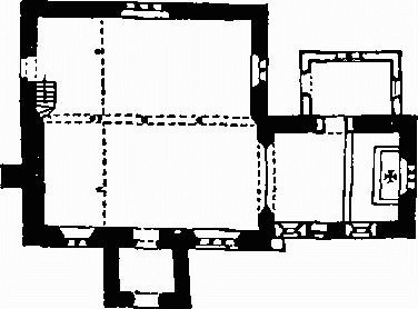
The Church, Plan
Architectural Description—The Chancel (18¼ ft. by 13 ft.), which has had the N. and S. walls lowered since 1804, has a late 13th-century E. window and a modern doorway in the N. wall to the vestry. In the S. wall are two 19th-century windows and, between them, a blocked 13th-century doorway with continuous chamfered jambs and two-centred head. The late 13th-century chancel arch has been rebuilt and widened; it is two-centred and of two orders, the inner hollow-chamfered and the outer chamfered, with roll-moulded stops; the stop on the S. has been cut away to a splay.
The Nave (31¼ ft. by 15½ ft.) has had the N. wall removed entirely and replaced by three 19th-century cast-iron columns. The S. wall has a chamfered plinth and a moulded string close under the eaves. High up at the E. end is a small single-light window probably of the 14th century with an ogee opening and pierced spandrels in a square head with a flat chamfered rear arch; it is over the E. haunch of a large 15th-century window of three cinque-foiled lights with vertical tracery in a distorted two-centred head with a label with coarsely-cut head-stops of a man and a woman. The S. doorway has a two-centred head and may be of the 13th century; it has been plastered and heavily coated with paint. The much altered and partly reset 14th-century window further W. is of two trefoiled lights with a quatrefoil in a two-centred head; it was perhaps transomed; the reveals are chamfered externally and, internally, they and the mullion are rebated for shutters; the lights have been extended downward some 3 ft., a transom being reused as the sill. The gabled W. wall has a central buttress in three stages and at the gable apex is an ashlar bell-cote with two round-headed openings under a gablet with trefoiled capstone.
The North Aisle (14½ ft. wide) is gabled to the E. and W. and each end wall contains a two-light window; these and the three-light window in the N. wall have simple intersecting tracery in two-centred heads. The W. doorway has chamfered jambs, a two-centred chamfered head and a stone tablet above inscribed: 'This aisle built 1834 by subscription', and with the names of the churchwardens.
The South Porch (8½ ft. by 6½ ft.) is gabled to the S., the parapet having a flat stone coping and a trefoiled apex-stone. The entrance has a chamfered segmental head and chamfered jambs; above it is a small stone tablet with the initials and date IH 1722.
The Roofs are of the 19th century.
Fittings—Bells: two, inaccessible, said to be uninscribed, one recast c. 1900. Door: In entrance to S. porch, nail-studded plank door with strap hinges, 18th-century. Font: circular tub-shaped bowl with nearly straight sides, shallow band of fluted label-ornament under rim, bands of bead and interlace ornament round the lower part and three incised lines between, 12th-century, on modern cylindrical stem and step. Gallery: continuous across full width of W. end of church, with plain panelled front, 1834.
Monuments and Floor-slab. Monuments: In chancel—on S. wall, (1) to Rev. William Gorton, 1830, black and white marble tablet; (2) to Rev. John Mills Arnold, 1850, white and black marble wall-tablet with fluted side brackets, pediment and antefixae, by Raggett, Weymouth. In N. aisle—on N. wall, (3) to Philippus Keay, 1796, oval white marble wall-tablet; (4) to Charles Bowles, 1822, black and white marble tablet; (5) Purbeck marble slab with incised figure of priest in academical dress, crudely drawn, 15th-century, cut down and reset, on modern corbels. In churchyard—S. of chancel, (6) to Prudence, wife of William Davis, 1654/5, table-tomb with arched panel on side and moulded top. Floor-slab: At entrance to S. porch, rectangular, with traces of black-letter inscription in one corner.
Paintings: In nave, two framed oil paintings on canvas: 'Noli me tangere', after Raphael, late 18th-century; the Visitation (?), late 18th-century. Pulpit (Plate 28): six-sided, of oak with fluted and reeded styles, sides divided into three tiers of panels by enriched rails, the lower two tiers with round-headed panels cut out of the solid and containing arabesques of stylised trees, the uppermost with guilloche patterns, excepting one panel carved with the date and initials '1630 RW.IM.', with modern cornice, two plain modern sides and some modern repairs, on modern pine base. Stoup: E. of S. doorway, recess with roughly cut dishing in projecting sill with chamfered under edge, mediaeval. Tablets: In nave, high on W. wall, Creed and Lord's Prayer painted on cinquefoil-headed boards, 19th-century. Miscellaneous: In nave, in S. wall, grotesque head-stop, mediaeval.
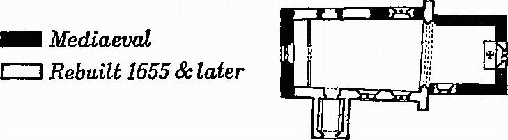
d(2) The former Parish Church of St. Nicholas, Buckland Ripers (651825), stands 1¼ m. N.N.E. of (1). The walls are of coursed local stone rubble with dressings of the same material, and the roofs are covered with blue slates with stone slates at the verges. The mediaeval building was badly damaged by fire about the middle of the 17th century and in 1655 was reconstructed; in that year James Frampton of Buckland left £20 towards the rebuilding. The church now includes a Chancel, Nave and South Porch, all, except perhaps the chancel, for the most part of the later date. It has been drastically restored in the past century.
Former Parish Church, Plan
Architectural Description—The Chancel (15 ft. by 13 ft.) has a gabled E. end without parapet and in the wall below is a late 19th-century two-light window. In the S. wall is a single-light window with square head and label; though of the 17th century and of two lights originally it has been much restored and the mullion removed. The chancel arch is of the date of the reconstruction in 1655, but widened subsequently to nearly the full width of the nave, the N. and S. walls of the chancel being cut back to accommodate the responds in their new positions; it is now of elliptical form, of two orders, with a keystone inscribed IF LW GC and extending into a shaped pendant; the outer hollow-chamfered order is continuous, the chamfered inner order springs from semi-octagonal responds with moulded capitals.
The Nave (29½ ft. by 16¾ ft.) has had a part of the N. wall and the part of the S. wall E. of the porch and the upper part of the rest rebuilt. In the N. wall is a mid 17th-century two-light window. The N. doorway further W. is probably of mediaeval origin though in rebuilt walling. The two 17th-century stone-mullioned windows in the S. wall are reset; they are of two square-headed lights with moulded labels and much restored. The S. doorway is of the 17th century and has chamfered jambs, segmental head and triangular rear arch. The W. wall is gabled, with a bell-cote on the apex of the gable; the W. window of c. 1500 has two cinque-foiled lights and sunk spandrels in a square head with a moulded label with square-return stops with foliated centres. The bell-cote is probably of the 17th century and has two plain segmental-headed openings under a gable.
The South Porch (5½ ft. by 7¾ ft.) has had the E. wall rebuilt since the 17th century. The entrance archway has chamfered jambs and segmental head and is dated 1655.
The Roofs are of the late 19th century.
Fittings—Bell: one, inaccessible. Font: octagonal stone bowl with plain sides and chamfered under edge on stop-chamfered square pedestal and round base, mediaeval. Plate: includes cup and stand-paten both of 1663, with maker's mark IG.
Secular
Unless otherwise described the houses are of two storeys, of rubble and with slate-covered roofs. Houses (3) and (29) are interesting examples of vernacular building.
Chickerell Village
North Square:
c(3) House is of the early 17th century. The walls are of thin, carefully coursed rubble with substantial quoins at the angles; the roofs are tiled. The plan originally comprised two heated rooms, the front doorway leading directly into the larger of the two, which was the hall. The original staircase was beside the hall fireplace. The central doorway has chamfered stone jambs and cambered head; flanking it asymmetrically are two three-light stone-mullioned windows; above these last are two smaller windows, originally of two lights but now with the mullions removed. In a garden wall is a reset stone inscribed NM 1625.
c(4) Cottage has walls of rendered rubble with brick dressings; the roofs are tiled. It was built in the early 19th century, and the plan comprises a staircase hall flanked by two rooms, each with a fireplace in the end gable wall.
c(5) House is of two storeys with attics and of rubble with a symmetrical brick front in Flemish bond; the mansard roof is tiled. A stone set between the first-floor windows is inscribed CRF 1788, the date of the building. The central doorway has a round head, and the flanking windows, one to each side on each floor, have segmental heads.
c(6) House has a thatched roof and is of the late 17th century. The ground floor has two heated rooms. Fixed on the front is a metal 'Imperial' insurance sign.
c(7) Former Barn, now a blacksmith's shop, has a tilecovered roof. A stone in the walling is inscribed WR 1758. It retains two old timber-framed windows.
c(8) Cottage has a symmetrical front and is of the early 19th century.
East Street:
c(9) Cottages, two, have thatched roofs and are dated 1829.
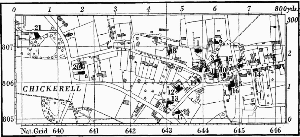
Chickerell
c(10) Cottages, two, semi-detached with adjoining living rooms, have some brick dressings and thatched roofs. They are ostensibly of the early 19th century but three stone buttresses on the E. side show that an earlier building has been incorporated, perhaps a small barn.
c(11) House, of two storeys with attics and of brick with a rendered front, has a mansard roof. It is of the late 18th century.
c(12) House, 'The Elms', is of two storeys with attics and of rendered brickwork with rusticated quoins. It is early Victorian. The ground floor has two large french windows flanking a doorway with a three-centred head, all opening to an iron veranda.
c(13) House has a central doorway above which is a stone inscribed 1578 IR. The plan originally comprised a hall and an unheated room, but no original partitions remain. The date 1829 has been cut on the original date stone and refers to the building of a brick wing at right angles to the earlier building.
c(14) House, of three storeys, with brick walls in part rendered, is of the early 19th century. The principal elevation, facing S. to the garden, is symmetrically designed and has a stucco plat-band at second-floor level. Over the garden gateway is a reset mediaeval corbel.
c(15) House is of the early 19th century with rendered walls and tiled roofs. The W. elevation has two three-light sash windows on each floor.
c(16) 'Turk's Head', public house, of the early 19th century, is similar to (15).
c(17) Cottages, two, of the early 19th century, were originally separate; they are now linked by a Victorian building.
West Street:
c(18) Bank Farm, house, is of the 17th century. The original doorway has stop-moulded jambs and four-centred head, and the two original windows are of three lights with hollow-chamfered mullions. The S. end has been rebuilt. Inside on the first floor is a 17th-century stone fireplace with a four-centred head and stop-chamfered jambs.
c(19) Cottage, with a thatched roof, was built in the 18th century. The very simple front is nearly symmetrical. On plan it has a central chimney with a fireplace in both the ground-floor rooms.
Chickerell Hill:
c(20) Former Workshop, of rubble and slate, is of the early 19th century. To the N., at right angles to it, is a contemporary range of cottages.
c(21) Morn Lodge, house, was built in the first half of the 19th century. The S. front has two windows on both ground and first floors with two-centred heads and interlacing glazingbars; the ground floor has a covered veranda with trelliswork supports to the roof. The E. side has a later brick extension to the N.; on the first floor is an original round window.
c(22) Barn (649805) at Putton, of rubble with a thatched roof, is of the early 19th century. It is about 56 ft. by 22 ft., with a porch on the W. side. A smaller porch on the E. side has been demolished.
a(23) House (645802), of brick, has a symmetrical front and is of c. 1830–40.
a(24) Montevideo House (647796), of two and three storeys, with walls of stucco-faced brickwork and a slate roof of low pitch behind a parapet, was built c. 1800 and altered in c. 1830. The windows have segmental heads. Four Cottages on the opposite (W.) side of the road are of c. 1830. The former Coach House, N.W. of the house, has a cupola with turned balusters and a swept, lead-covered roof surmounted by a weather-vane.
b(25) Cottage (650793) is of the early 19th century. It was heightened in brick later in the same century.
b(26) Cottages, two (651793), at Charlestown, of one storey with attics and with tiled roofs, are of the early 19th century.
Buckland Ripers
d(27) Manor House, N.E. of the church (2), is of two storeys; it is of stone, now faced with stucco, and the roofs, which were formerly thatch-covered, are slated. It was built in the second half of the 17th century, after the fire which had damaged the church and destroyed much of the village, and remodelled and extended subsequently, chiefly in the 19th century. The original building was L-shaped and now forms the S. and E. sides of the main part of the existing house.
c(28) Middle (formerly Buckland) Farm, house (647822), is of the early 17th century; scratched on the S. doorway is the date 1619. Nearly all the old features have been removed except on the S. side, where the doorway has a triangular head and the windows have ovolo-moulded mullions.
c(29) Tatton Farm, house (633827), now with a modern asbestos roof, is of the early 17th century. The original plan must have been unusual, though the S. end of the house has been so altered that the complete form is not recoverable. The proportions of the plan suggest it was divided originally by a through passage, no doubt formed by plank-and-muntin partitions, entered from the W. through the existing doorway with a four-centred head. The N. room has two three-light windows with hollow-chamfered mullions. The S. room was smaller, with a projection on the W. side, presumably for a staircase. At the S. end of this projection is a blocked doorway; at the N. end, at about the same height as the first-floor joists, is a small blocked window. A modern wing abuts the projection.
d(30) Cottages, four (654831), at Holwell, are of the early 19th century. They were built two rooms thick, with two storeys at the front and one at the back; to the latter a second storey has since been added. The plan of each cottage comprised two rooms. N.E. of the foregoing is a Range comprising a house, with a tiled roof, and a barn. The house may be of the late 18th century, the barn rather later.
Earthworks, Etc.
Mediaeval and Later Earthworks
c(31) Settlement Remains at Putton (64958035) lie 700 yds. S.E. of St. Mary's church on ground sloping gently E. and N. at about 100 ft. above O.D. The first known reference to Putton is in 1237 (Fägersten, 153).
Several small banked and scarped closes cover some 3 acres around a hollow-way in pasture immediately E. of Putton Lane opposite Fairfield House. The hollow-way, up to 30 ft. wide and 4 ft. deep, runs N. for 100 yds. from the angle in the road; another apparent hollow-way runs up to this angle from the E. Three closes W. of the N. to S. hollow-way are each of about 1/5 acre and roughly square; two to the E., about 75 ft. and 105 ft. wide, seem originally to have been about 300 ft. long. Pottery from pipe trenches immediately N. of the remains is largely of the 14th and 15th centuries, though some might be 16th-century. Much stone rubble and variations in the depth of loam over the clay subsoil were noted in one of these trenches.
Hedgerows preserve a pattern of enclosed strip fields E. and S.E. of the earthworks. Some of these fields apparently formed part of 'Putton Plain', completely enclosed by 1792. There were also an East Field and a West Field. (Enclosure award, but no map, in D.C.R.O.; R.A.F. V.A.P. CPE/UK 1821: 2458.)
c(32) Settlement Remains (634827) lie over a small area immediately E. of Tatton Farm (Monument 29), formerly in Buckland Ripers parish. Vestiges of two closes abut on a ditch or hollow-way. 'Tatetun' occurs in Domesday Book. (Hutchins II, 491; Fägersten, 158; R.A.F. V.A.P. CPE/UK 1821: 6456.)
d(33) Settlement Remains (65128252 to 65528237), formerly part of the village of Buckland Ripers and in the old parish of that name, lie S. and S.E. of the Manor House (Monument 27). They cover 3 acres and are much disturbed but include closes about 360 ft. long and of unequal widths, bounded by banks 1 ft. high. (Hutchins II, 491; Fägersten, 157; R.A.F. V.A.P. CPE/UK 1821: 4460.)
Other Earthworks and Allied Monuments (34–35) Roman Remains, p. 595.